Victorian Midlands
Region in Victoria, Australia
| Victorian Midlands Victoria | |||||||||||||||
|---|---|---|---|---|---|---|---|---|---|---|---|---|---|---|---|
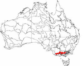 The interim Australian bioregions, with the Victorian Midlands in red | |||||||||||||||
| Area | 34,697.89 km2 (13,396.9 sq mi) | ||||||||||||||
| |||||||||||||||
The Victorian Midlands is an interim Australian bioregion located in central Victoria.[1] It has an area of 3,469,789 hectares (8,574,040 acres).[2] The Victorian Midlands bioregion is part of the Southeast Australia temperate forests ecoregion.
Subregions
The Victorian Midlands bioregion consists of four subregions:
- Goldfields (VIM01) – 1,326,133 hectares (3,276,950 acres)
- Central Victorian Uplands (VIM02) – 1,217,922 hectares (3,009,550 acres)
- Greater Grampians (VIM03) – 237,416 hectares (586,670 acres)
- Dundas Tablelands (VIM04) – 688,318 hectares (1,700,870 acres)
References
- ^ Environment Australia. "Revision of the Interim Biogeographic Regionalisation for Australia (IBRA) and Development of Version 5.1 – Summary Report" (PDF). Department of the Environment and Water Resources, Australian Government. Retrieved 6 May 2022.
{{cite journal}}: Cite journal requires|journal=(help) - ^ "Interim Biogeographic Regionalisation for Australia (IBRA7) regions and codes". Department of Sustainability, Environment, Water, Population and Communities. Commonwealth of Australia. 2012. Retrieved 6 May 2022.
- v
- t
- e
- Arnhem Coast
- Arnhem Plateau
- Australian Alps
- Avon Wheatbelt
- Ben Lomond
- Brigalow Belt North
- Brigalow Belt South
- Broken Hill Complex
- Burt Plain
- Cape York Peninsula
- Carnarvon
- Central Arnhem
- Central Kimberley
- Central Mackay Coast
- Central Ranges
- Channel Country
- Cobar Peneplain
- Coolgardie
- Coral Sea
- Cumberland Plain
- Daly Basin
- Dampierland
- Darling Riverine Plains
- Darwin Coastal
- Davenport Murchison Ranges
- Desert Uplands
- Einasleigh Uplands
- Esperance Plains
- Eyre Yorke Block
- Finke
- Flinders Lofty Block
- Furneaux
- Gascoyne
- Gawler
- Geraldton Sandplains
- Gibson Desert
- Great Sandy Desert
- Great Victoria Desert
- Gulf Coastal
- Gulf Fall and Uplands
- Gulf Plains
- Hampton
- Indian Tropical Islands
- Jarrah Forest
- Kanmantoo
- King
- Little Sandy Desert
- MacDonnell Ranges
- Mallee
- Mitchell Grass Downs
- Mount Isa Inlier
- Mulga Lands
- Murchison
- Murray Darling Depression
- Nandewar
- Naracoorte Coastal Plain
- New England Tablelands
- Northern Kimberley
- New South Wales North Coast
- New South Wales South Western Slopes
- Nullarbor Plain
- Ord Victoria Plain
- Pacific Subtropical Islands
- Pine Creek
- Pilbara
- Riverina
- Simpson Strzelecki Dunefields
- South East Coastal Plain
- South East Corner
- South Eastern Highlands
- South Eastern Queensland
- Southern Volcanic Plain
- Stony Plains
- Sturt Plateau
- Subantarctic Islands
- Swan Coastal Plain
- Sydney Basin
- Tanami
- Tasmanian Central Highlands
- Tasmanian Northern Midlands
- Tasmanian Northern Slopes
- Tasmanian South East
- Tasmanian Southern Ranges
- Tasmanian West
- Tiwi Cobourg
- Victoria Bonaparte
- Victorian Midlands
- Warren
- Wet Tropics
- Yalgoo
 | This article about a location in Victoria, Australia is a stub. You can help Wikipedia by expanding it. |
- v
- t
- e


