Tasmanian South East
Bioregion in Tasmania, Australia
| Tasmanian South East Tasmania | |||||||||||||||
|---|---|---|---|---|---|---|---|---|---|---|---|---|---|---|---|
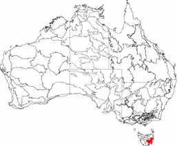 The interim Australian bioregions, with the Tasmanian South East in red | |||||||||||||||
| Area | 1,132 km2 (437.1 sq mi) | ||||||||||||||
| |||||||||||||||
The Tasmanian South East is an interim Australian bioregion located in the south-eastern region of Tasmania, comprising 1,131,822 hectares (2,796,790 acres).[1][2]
Much of the region aligns with the Tasmanian temperate forests ecoregion.
See also
 Australia portal
 Environment portal


- Ecoregions in Australia
- Regions of Tasmania
References
- ^ "Interim Biogeographic Regionalisation for Australia (IBRA7) regions and codes". Department of Sustainability, Environment, Water, Population and Communities. Australian Government. 2012. Retrieved 13 January 2013.
- ^ "Interim Biogeographic Regionalisation for Australia, Version 7" (PDF). Department of Sustainability, Environment, Water, Population and Communities. Australian Government. 2012. Retrieved 14 April 2015.
Further reading
- Thackway, R.; Cresswell, I. D. (1995). An interim biogeographic regionalisation for Australia : a framework for setting priorities in the National Reserves System Cooperative Program: Version 4.0. Canberra: Australian Nature Conservation Agency, Reserve Systems Unit. ISBN 0-642-21371-2.
- v
- t
- e
- Arnhem Coast
- Arnhem Plateau
- Australian Alps
- Avon Wheatbelt
- Ben Lomond
- Brigalow Belt North
- Brigalow Belt South
- Broken Hill Complex
- Burt Plain
- Cape York Peninsula
- Carnarvon
- Central Arnhem
- Central Kimberley
- Central Mackay Coast
- Central Ranges
- Channel Country
- Cobar Peneplain
- Coolgardie
- Coral Sea
- Cumberland Plain
- Daly Basin
- Dampierland
- Darling Riverine Plains
- Darwin Coastal
- Davenport Murchison Ranges
- Desert Uplands
- Einasleigh Uplands
- Esperance Plains
- Eyre Yorke Block
- Finke
- Flinders Lofty Block
- Furneaux
- Gascoyne
- Gawler
- Geraldton Sandplains
- Gibson Desert
- Great Sandy Desert
- Great Victoria Desert
- Gulf Coastal
- Gulf Fall and Uplands
- Gulf Plains
- Hampton
- Indian Tropical Islands
- Jarrah Forest
- Kanmantoo
- King
- Little Sandy Desert
- MacDonnell Ranges
- Mallee
- Mitchell Grass Downs
- Mount Isa Inlier
- Mulga Lands
- Murchison
- Murray Darling Depression
- Nandewar
- Naracoorte Coastal Plain
- New England Tablelands
- Northern Kimberley
- New South Wales North Coast
- New South Wales South Western Slopes
- Nullarbor Plain
- Ord Victoria Plain
- Pacific Subtropical Islands
- Pine Creek
- Pilbara
- Riverina
- Simpson Strzelecki Dunefields
- South East Coastal Plain
- South East Corner
- South Eastern Highlands
- South Eastern Queensland
- Southern Volcanic Plain
- Stony Plains
- Sturt Plateau
- Subantarctic Islands
- Swan Coastal Plain
- Sydney Basin
- Tanami
- Tasmanian Central Highlands
- Tasmanian Northern Midlands
- Tasmanian Northern Slopes
- Tasmanian South East
- Tasmanian Southern Ranges
- Tasmanian West
- Tiwi Cobourg
- Victoria Bonaparte
- Victorian Midlands
- Warren
- Wet Tropics
- Yalgoo
Southern region of Tasmania, Australia | |||||
|---|---|---|---|---|---|
| Settlements | |||||
| Governance |
| ||||
| Mountains |
| ||||
| Protected areas, parks and reserves | |||||
| Rivers |
| ||||
| Harbours, bays, inlets and estuaries | |||||
| Coastal features | |||||
| Transport | |||||
| Landmarks |
| ||||
| Islands | |||||
| Books and newspapers |
| ||||
| Flora, fauna, and fishlife |
| ||||
| Bioregions |
| ||||
| Indigenous heritage | |||||
| Other | |||||
| |||||

East Coast region of Tasmania, Australia | |||||
|---|---|---|---|---|---|
| Settlements | |||||
| Governance former | |||||
| Mountains | |||||
| Protected areas, parks and reserves | |||||
| Harbours, bays, inlets and estuaries |
| ||||
| Landmarks |
| ||||
| People of note | |||||
| Islands |
| ||||
| Books and newspapers | |||||
| Flora, fauna, and fishlife | |||||
| Bioregions |
| ||||
| |||||
 | This Tasmania article is a stub. You can help Wikipedia by expanding it. |
- v
- t
- e


