Tanami bioregion
Region in Australia
| Tanami Australia | |||||||||||||||
|---|---|---|---|---|---|---|---|---|---|---|---|---|---|---|---|
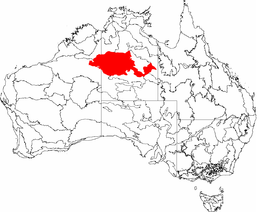 The interim Australian bioregions, with Tanami in red | |||||||||||||||
| Area | 259,972.77 km2 (100,376.0 sq mi) | ||||||||||||||
| |||||||||||||||
Tanami (Warlpiri: Jarnami)[1] is an interim Australian bioregion, comprising 25,997,277 hectares (64,240,670 acres) in the Northern Territory and Western Australia.[2] It is part of the Great Sandy-Tanami desert ecoregion.
The bioregion has the code TAN.[3] There are three subregions.[3]
| IBRA regions and subregions: IBRA7 | ||||
|---|---|---|---|---|
| IBRA region / subregion | IBRA code | Area | States | Location in Australia |
| Tanami | TAN | 25,997,277 hectares (64,240,670 acres) | NT / WA |  |
| Tanami Desert | TAN01 | 20,769,151 hectares (51,321,690 acres) | ||
| Wycliffe | TAN02 | 1,600,893 hectares (3,955,890 acres) | ||
| Sandover | TAN03 | 3,627,233 hectares (8,963,090 acres) | ||
See also
 Western Australia portal
 Environment portal


- Geography of Australia
References
- ^ "English - Warlpiri".
- ^ Environment Australia. "Revision of the Interim Biogeographic Regionalisation for Australia (IBRA) and Development of Version 5.1 – Summary Report" (PDF). Department of the Environment and Water Resources, Government of Australia. Retrieved 9 May 2022.
{{cite journal}}: Cite journal requires|journal=(help) - ^ a b "Interim Biogeographic Regionalisation for Australia (IBRA7) regions and codes". Department of Sustainability, Environment, Water, Population and Communities. Commonwealth of Australia. 2012. Retrieved 13 January 2013.
Further reading
- Thackway, R and I D Cresswell (1995) An interim biogeographic regionalisation for Australia : a framework for setting priorities in the National Reserves System Cooperative Program Version 4.0 Canberra : Australian Nature Conservation Agency, Reserve Systems Unit, 1995. ISBN 0-642-21371-2
- v
- t
- e
- Arnhem Coast
- Arnhem Plateau
- Australian Alps
- Avon Wheatbelt
- Ben Lomond
- Brigalow Belt North
- Brigalow Belt South
- Broken Hill Complex
- Burt Plain
- Cape York Peninsula
- Carnarvon
- Central Arnhem
- Central Kimberley
- Central Mackay Coast
- Central Ranges
- Channel Country
- Cobar Peneplain
- Coolgardie
- Coral Sea
- Cumberland Plain
- Daly Basin
- Dampierland
- Darling Riverine Plains
- Darwin Coastal
- Davenport Murchison Ranges
- Desert Uplands
- Einasleigh Uplands
- Esperance Plains
- Eyre Yorke Block
- Finke
- Flinders Lofty Block
- Furneaux
- Gascoyne
- Gawler
- Geraldton Sandplains
- Gibson Desert
- Great Sandy Desert
- Great Victoria Desert
- Gulf Coastal
- Gulf Fall and Uplands
- Gulf Plains
- Hampton
- Indian Tropical Islands
- Jarrah Forest
- Kanmantoo
- King
- Little Sandy Desert
- MacDonnell Ranges
- Mallee
- Mitchell Grass Downs
- Mount Isa Inlier
- Mulga Lands
- Murchison
- Murray Darling Depression
- Nandewar
- Naracoorte Coastal Plain
- New England Tablelands
- Northern Kimberley
- New South Wales North Coast
- New South Wales South Western Slopes
- Nullarbor Plain
- Ord Victoria Plain
- Pacific Subtropical Islands
- Pine Creek
- Pilbara
- Riverina
- Simpson Strzelecki Dunefields
- South East Coastal Plain
- South East Corner
- South Eastern Highlands
- South Eastern Queensland
- Southern Volcanic Plain
- Stony Plains
- Sturt Plateau
- Subantarctic Islands
- Swan Coastal Plain
- Sydney Basin
- Tanami
- Tasmanian Central Highlands
- Tasmanian Northern Midlands
- Tasmanian Northern Slopes
- Tasmanian South East
- Tasmanian Southern Ranges
- Tasmanian West
- Tiwi Cobourg
- Victoria Bonaparte
- Victorian Midlands
- Warren
- Wet Tropics
- Yalgoo
| ||
|---|---|---|
| Topics |  | |
| Regions | ||
| Major settlements | ||


