Old Cutler Road
Road in Miami-Dade County, Florida
| Ingraham Highway | |
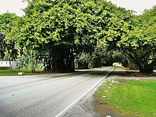 Old Cutler Road as it passes through a tree tunnel in Coral Gables | |
| Length | 14.9 mi (24.0 km) |
|---|---|
| Southwest end |  US 1 in Goulds US 1 in Goulds |
| Northeast end | Sunset Drive and LeJeune Road at Cocoplum Circle in Coral Gables, Florida |
| Construction | |
| Inauguration | 1895[1] |
Old Cutler Road is an off-grid plan, 14.9-mile (24.0 km) main northeast–southwest road running south of downtown Miami in Miami-Dade County, Florida, United States.
Route description
The northern terminus is Cocoplum Circle at the edge of the Coral Gables Waterway in the city of Coral Gables. It connects at the circle with LeJeune Road, Sunset Drive, Ingraham Highway and Cocoplum Road.
From this point south it goes through Coral Gables until it intersects with Red Road (West 57th Avenue). It then shares its name with Red Road, going due south for a short distance dividing the city of Coral Gables to the east with the village of Pinecrest to the west. It fully enters the village of Pinecrest upon crossing South 128th Street (Lugo Avenue).[2]
It continues southwest through Pinecrest until it curves due west and shares its name with South 136th Street dividing the village of Pinecrest to the north with the village of Palmetto Bay to the south for a short distance until it crosses West 67th Avenue (Ludlam Road) where it veers southwest and separates from South 136th Street as only Old Cutler Road again.[3]
It continues south-southwest through Palmetto Bay until it crosses South 184th Street and enters the town of Cutler Bay. It continues southwest through Cutler Bay until it crosses South 216th Street (Hainlin Mill Drive) where it divides the town of Cutler Bay to the east with unincorporated Miami-Dade County to the west, until it crosses Southwest 224th Street where it fully enters unincorporated Miami-Dade County and curves due west.
It continues west as Old Cutler Road until it crosses West 107th Avenue and becomes West Old Cutler Road. It continues west-northwest as West Old Cutler Road until it crosses West 112th Avenue and shares its name with South 220th Street. South 220th Street is no longer called West Old Cutler Road west of US 1.
Historical Notes
The origins of this coastal route predates the building of roads in Dade County, as a trail along the high ridge of South Florida's coastline, often referred to by pioneer settlers as "The Reef."
From the state historical marker placed on the road: "Old Cutler Road owes its name to the former town of Cutler, a farming community founded by William Fuzzard in the late 1800s. The town was named after Dr. William Cutler of Massachusetts who visited the area about 1880 and encouraged Fuzzard and others to settle here. In 1883, Fuzzard, with the help of other residents of Cutler, cut a path north and east through a wilderness of pine rocklands and hardwood hammocks to the Village of Coconut Grove. The road followed a natural limestone ridge along Biscayne Bay, and established the first overland route connecting Coconut Grove and Cutler. It was subsequently widened to a wagon trail, and was declared a public road in 1895. The road became known as Cutler Road, later as Ingraham Highway, and still later as Old Cutler Road. Today, Old Cutler Road, which follows a somewhat altered course, maintains the appearance and atmosphere of a country road, and provides a tangible reminder of the heritage of the Miami area. Old Cutler Road was declared a State Historic Highway in 1974 by the Florida Legislature."[4][5][6]
Progress on paving the route was greatly improved by installing a concrete bridge over Snapper Creek in 1916. Soon, the road reached all the way to Paradise Key and Royal Palm State Park, a magnificent natural area featuring the largest stand of Royal Palms in North America (later part of Everglades National Park).
In 1916 members of the Miami Woman's Club successfully petitioned the Dade County Commission[7] to name the road in honor of James Ingraham, brought in by Mr. Flagler as his Land Commissioner to manage FEC land holdings, buying, selling and attaining them as grants. Eventually, the FEC Land Department became the Model Land Company and Mr. Ingraham was given the title of “3rd Vice President,” in charge of that company.
The completion of Ingraham Highway to the Everglades was instrumental in the establishment of Florida's first state park: Royal Palm State Park, owned by the General Federation of Woman's Clubs.[8]
Several prominent land owners were successful in diverting the original highway around their properties. Just south of Snapper Creek, the road once ran through the Montgomery Estate (now Montgomery Botanical Center), right past the main house, proceeding through what is now the Gulliver School property.
Further south, the road ran through Chapman Field USDA Subtropical Horticulture Research Station, and further, through the Charles Deering Estate, past the historic Richmond Cottage early settlement on Biscayne Bay.
From the History of Chapman Field: "Within the USDA Station at Chapman field, an access road west of and parallel to 60th Avenue is a remnant of the old Ingraham Highway, which was relocated about three quarters of a mile to the west as the base was constructed. Ingraham Highway would eventually be renamed Old Cutler Road."[9]
Deering successfully petitioned the Dade County Commission to allow him to divert the road around his estate in exchange for building a public dock at the south end of his property which would allow local farmers and the general public direct access to Biscayne Bay.[7]
Remnants of the old road still run through these properties, and some portions of the original route, notably in Coconut Grove and near the entrance to Everglades National Park, still carry the name Ingraham Highway.
References
- ^ "Florida Historical Markers Programs - Marker: Miami-Dade - Preservation - Florida Division of Historical Resources".
- ^ "Village of Pinecrest Map" (PDF). Archived from the original (PDF) on October 1, 2006.
- ^ "Village of Palmetto Bay Map" (PDF). Archived from the original (PDF) on September 30, 2006.
- ^ "Old Cutler Road - Florida Historical Markers on Waymarking.com". www.waymarking.com. Retrieved April 22, 2018.
- ^ "SPECIAL ACTS and GENERAL ACTS of LOCAL APPLICATION ADOPTED BY THE THIRD LEGISLATURE OF FLORIDA UNDER THE CONSTITUTION AS REVISED IN 1968" (PDF). Laws of Florida. April 2, 1974. Retrieved June 19, 2018.
- ^ "Old Cutler Road, Town of Cutler Bay". State Library and Archives of Florida. May 22, 2007. Retrieved June 19, 2018.
- ^ a b "robertburr.com - robertburr Resources and Information". www.robertburr.com. Retrieved April 22, 2018.
- ^ "Royal Palm State Park Re-Dedication - GFWC". gfwc.org. November 30, 2016. Retrieved April 22, 2018.
- ^ Pinecrest Florida [dead link]
25°35′36″N 80°19′12″W / 25.5932967°N 80.3200195°W / 25.5932967; -80.3200195
- v
- t
- e
- Downtown Miami
- Arts & Entertainment District
- Brickell
- Central Business District
- Historic District
- Government Center
- Park West
and universities
- Barry University
- Broward College
- Carlos Albizu University
- Florida Atlantic University
- Florida International University
- Florida Memorial University
- Johnson & Wales University
- Miami Dade College
- Miami International University of Art & Design
- Nova Southeastern University
- St. Thomas University
- University of Fort Lauderdale
- University of Miami
- Alice Wainwright Park
- Amelia Earhart Park
- Arch Creek
- The Barnacle Historic State Park
- Bayfront Park
- Big Cypress National Preserve
- Bill Baggs Cape Florida State Park
- Biscayne National Park
- Brian Piccolo Sports Park & Velodrome
- Chapman Field Park
- Crandon Park
- Dinner Key
- Everglades National Park
- Fairchild Tropical Botanic Garden
- Fort Dallas
- Fruit & Spice Park
- Greynolds Park
- Haulover Park
- Jungle Island
- The Kampong
- Margaret Pace Park
- Matheson Hammock Park
- Miami Seaquarium
- Monkey Jungle
- Museum Park
- Oleta River State Park
- Peacock Park
- Pride Park, Miami Beach FL
- Shark Valley
- Simpson Park Hammock
- South Pointe Park
- Tamiami Park
- Tropical Park
- The Underline
- Virginia Key
- Zoo Miami
- Adrienne Arsht Center for the Performing Arts
- Amerant Bank Arena
- Bass Museum
- Bergeron Rodeo Grounds
- Biltmore Hotel
- Bonita Chita Key
- Broward County Convention Center
- Butterfly World
- Coral Castle
- Downtown Miami
- FIU Stadium
- Florida Grand Opera
- Fontainebleau Miami Beach
- Fort Lauderdale Swap Shop
- Frost Art Museum
- Frost School of Music
- Gulfstream Park
- Hard Rock Stadium
- HistoryMiami
- Holocaust Memorial
- Homestead
- Jewish Museum of Florida
- Kaseya Center
- Las Olas Boulevard
- LoanDepot Park
- Lowe Art Museum
- Lincoln Road
- Lummus Park
- MacFarlane Homestead
- Miami Beach Architectural District
- Miami Beach Convention Center
- Miami Children's Museum
- Miami City Ballet
- Miami Conservatory
- Museum of Contemporary Art
- New World Symphony Orchestra
- Normandy Isles
- North Shore
- Ocean Bank Convocation Center
- Ocean Drive
- Phillip and Patricia Frost Museum of Science
- Pérez Art Museum Miami
- Riverwalk
- Seminole Hard Rock Hotel & Casino Hollywood
- South Beach
- The Miami Line
- Vizcaya Museum and Gardens
- Watsco Center
- Wolfsonian-FIU
- Wynwood Art District
- Aventura Mall
- Bal Harbour Shops
- Bayside Marketplace
- Boynton Beach Mall
- Brickell City Centre
- Broward Mall
- CocoWalk
- Coral Square
- Dadeland Mall
- Dolphin Mall
- The Falls
- The Galleria at Fort Lauderdale
- The Gardens Mall
- Lincoln Road
- The Mall at 163rd Street
- Mary Brickell Village
- Miami International Mall
- Midtown Miami
- Midway Crossings
- Miracle Marketplace
- Pembroke Lakes Mall
- The Promenade at Coconut Creek
- The Shops at Sunset Place
- Sawgrass Mills
- Southland Mall
- Shops at Merrick Park
- Town Center at Boca Raton
- Westland Mall
- Amtrak
- Broward County Transit
- Brightline
- Government Center
- Fort Lauderdale Executive Airport
- Fort Lauderdale–Hollywood International Airport
- Miami-Dade Transit
- Metrobus
- Metromover
- Metrorail
- MIA Mover
- MiamiCentral
- Miami Intermodal Center
- Miami International Airport
- Miami–Opa Locka Executive Airport
- North Perry Airport
- Palm Beach International Airport
- Palm Tran
- Pompano Beach Airpark
- Port Everglades
- PortMiami
- Tri-Rail
- East 6th Avenue
- North 36th Street
- North 54th Street
- North 79th Street
- North 103rd Street
- North 125th Street
- North 135th Street
- West 7th Avenue
- West 12th Avenue
- West 27th Avenue
- West 107th Avenue
- Allapattah Road
- Alton Road
- Bird Road
- Biscayne Boulevard
- Brickell Avenue
- Broad Causeway
- Collins Avenue
- Coral Reef Drive
- Coral Way
- County Line Road
- Douglas Road
- Flagler Street
- Galloway Road
- Gratigny
- Ives Dairy Road
- Julia Tuttle Causeway
- Kendall Drive
- John F. Kennedy Causeway
- Killian
- Krome Avenue
- William Lehman Causeway
- Le Jeune Road
- Ludlam Road
- MacArthur Causeway
- Miami Avenue
- Miami Gardens Drive
- Milam Dairy Road
- Miracle Mile
- Okeechobee Road
- Old Cutler Road
- Port Boulevard
- Quail Roost Drive
- Red Road
- Rickenbacker Causeway
- South Dixie Highway
- Sunset Drive
- Tamiami Trail
- University Drive
- Venetian Causeway
- West Dixie Highway
 WikiProject


