Normandy Isles Historic District
Historic district in Florida, United States
United States historic place
Normandy Isles Historic District | |
 | |
25°51′16.4″N 80°7′51.7″W / 25.854556°N 80.131028°W / 25.854556; -80.131028 | |
| NRHP reference No. | 08001041[1] |
|---|---|
| Added to NRHP | November 12, 2008[1] |
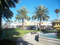
Normandy Isles Historic District is a U.S. Historic District encompassing the Normandy Isles neighborhood of Miami Beach, Florida. It is roughly bounded by the Normandy Shores Golf Course, Indian Creek, Biscayne Bay, Rue Versailles, 71st Street, and Rue Notre Dame. On November 12, 2008, it was added to the U.S. National Register of Historic Places.[1]
References
- ^ a b c "Weekly List Of Actions Taken On Properties: 11/3/08 through 11/7/08". National Register of Historic Places. National Park Service. December 30, 2008.
External links
Wikimedia Commons has media related to Normandy Isles Historic District.
- Normandy Isles Historic District boundary map
- v
- t
- e
Greater Miami Area
- Downtown Miami
- Arts & Entertainment District
- Brickell
- Central Business District
- Historic District
- Government Center
- Park West
- Boca Raton
- Boynton Beach
- Coral Gables
- Coral Springs
- Deerfield Beach
- Delray Beach
- Doral
- Fort Lauderdale
- Hialeah
- Hollywood
- Jupiter
- Kendall
- Miami Beach
- Miami Gardens
- Miramar
- Palm Beach Gardens
- Pembroke Pines
- Pompano Beach
- Sunrise
- West Palm Beach
and universities
- Barry University
- Broward College
- Carlos Albizu University
- Florida Atlantic University
- Florida International University
- Florida Memorial University
- Johnson & Wales University
- Miami Dade College
- Miami International University of Art & Design
- Nova Southeastern University
- St. Thomas University
- University of Fort Lauderdale
- University of Miami
- Alice Wainwright Park
- Amelia Earhart Park
- Arch Creek
- The Barnacle Historic State Park
- Bayfront Park
- Big Cypress National Preserve
- Bill Baggs Cape Florida State Park
- Biscayne National Park
- Brian Piccolo Sports Park & Velodrome
- Chapman Field Park
- Crandon Park
- Dinner Key
- Everglades National Park
- Fairchild Tropical Botanic Garden
- Fort Dallas
- Fruit & Spice Park
- Greynolds Park
- Haulover Park
- Jungle Island
- The Kampong
- Margaret Pace Park
- Matheson Hammock Park
- Miami Seaquarium
- Monkey Jungle
- Museum Park
- Oleta River State Park
- Peacock Park
- Pride Park, Miami Beach FL
- Shark Valley
- Simpson Park Hammock
- South Pointe Park
- Tamiami Park
- Tropical Park
- The Underline
- Virginia Key
- Zoo Miami
- Adrienne Arsht Center for the Performing Arts
- Amerant Bank Arena
- Bass Museum
- Bergeron Rodeo Grounds
- Biltmore Hotel
- Bonita Chita Key
- Broward County Convention Center
- Butterfly World
- Coral Castle
- Downtown Miami
- FIU Stadium
- Florida Grand Opera
- Fontainebleau Miami Beach
- Fort Lauderdale Swap Shop
- Frost Art Museum
- Frost School of Music
- Gulfstream Park
- Hard Rock Stadium
- HistoryMiami
- Holocaust Memorial
- Homestead
- Jewish Museum of Florida
- Kaseya Center
- Las Olas Boulevard
- LoanDepot Park
- Lowe Art Museum
- Lincoln Road
- Lummus Park
- MacFarlane Homestead
- Miami Beach Architectural District
- Miami Beach Convention Center
- Miami Children's Museum
- Miami City Ballet
- Miami Conservatory
- Museum of Contemporary Art
- New World Symphony Orchestra
- Normandy Isles
- North Shore
- Ocean Bank Convocation Center
- Ocean Drive
- Phillip and Patricia Frost Museum of Science
- Pérez Art Museum Miami
- Riverwalk
- Seminole Hard Rock Hotel & Casino Hollywood
- South Beach
- The Miami Line
- Vizcaya Museum and Gardens
- Watsco Center
- Wolfsonian-FIU
- Wynwood Art District
- Aventura Mall
- Bal Harbour Shops
- Bayside Marketplace
- Boynton Beach Mall
- Brickell City Centre
- Broward Mall
- CocoWalk
- Coral Square
- Dadeland Mall
- Dolphin Mall
- The Falls
- The Galleria at Fort Lauderdale
- The Gardens Mall
- Lincoln Road
- The Mall at 163rd Street
- Mary Brickell Village
- Miami International Mall
- Midtown Miami
- Midway Crossings
- Miracle Marketplace
- Pembroke Lakes Mall
- The Promenade at Coconut Creek
- The Shops at Sunset Place
- Sawgrass Mills
- Southland Mall
- Shops at Merrick Park
- Town Center at Boca Raton
- Westland Mall
- Amtrak
- Broward County Transit
- Brightline
- Government Center
- Fort Lauderdale Executive Airport
- Fort Lauderdale–Hollywood International Airport
- Miami-Dade Transit
- Metrobus
- Metromover
- Metrorail
- MIA Mover
- MiamiCentral
- Miami Intermodal Center
- Miami International Airport
- Miami–Opa Locka Executive Airport
- North Perry Airport
- Palm Beach International Airport
- Palm Tran
- Pompano Beach Airpark
- Port Everglades
- PortMiami
- Tri-Rail
- East 6th Avenue
- North 36th Street
- North 54th Street
- North 79th Street
- North 103rd Street
- North 125th Street
- North 135th Street
- West 7th Avenue
- West 12th Avenue
- West 27th Avenue
- West 107th Avenue
- Allapattah Road
- Alton Road
- Bird Road
- Biscayne Boulevard
- Brickell Avenue
- Broad Causeway
- Collins Avenue
- Coral Reef Drive
- Coral Way
- County Line Road
- Douglas Road
- Flagler Street
- Galloway Road
- Gratigny
- Ives Dairy Road
- Julia Tuttle Causeway
- Kendall Drive
- John F. Kennedy Causeway
- Killian
- Krome Avenue
- William Lehman Causeway
- Le Jeune Road
- Ludlam Road
- MacArthur Causeway
- Miami Avenue
- Miami Gardens Drive
- Milam Dairy Road
- Miracle Mile
- Okeechobee Road
- Old Cutler Road
- Port Boulevard
- Quail Roost Drive
- Red Road
- Rickenbacker Causeway
- South Dixie Highway
- Sunset Drive
- Tamiami Trail
- University Drive
- Venetian Causeway
- West Dixie Highway
 WikiProject
 | This article about a property in Miami-Dade County, Florida on the National Register of Historic Places is a stub. You can help Wikipedia by expanding it. |
- v
- t
- e


