Amelia Earhart Park
Urban park in unincorporated Miami-Dade County, Florida
| Amelia Earhart Park | |
|---|---|
 Lakeshore near the park's main road, a disk golf course in the distance | |
 | |
| Type | Municipal |
| Location | Miami, Miami-Dade County, Florida, United States |
| Area | 515 acres (0.805 sq mi) |
| Created | 1980 (1980) |
| Operated by | Miami-Dade County Parks and Recreation Department |
| Website | Amelia Earhart Park |
Amelia Earhart Park is a 515-acre (208.41 ha) urban park in unincorporated Miami-Dade County, just north of Hialeah, Florida. It offers a number of recreational attractions like bike trails, skateboarding, and fishing.
History
This Miami-Dade County regional park was the southern undeveloped portion of decades old Naval Air Station Miami. It was never an airport and never part of the City of Miami-owned Miami Municipal Airport which was on the east side of LeJeune Road and south of NW 119th Street (E. 65th Street) in Hialeah. Amelia Earhart's last ill-fated trip around the world flight left from Miami Municipal Airport in 1937 en route to San Juan, PR, and then south from there and across the Atlantic to Africa. Miami Municipal Airport was renamed Amelia Earhart Field in October 1947. When the Navy discontinued operations at Naval Air Station Miami the U. S. Marine Corps moved to the Navy property from Master Field, another large airport on NW 27th Avenue, east of Amelia Earhart Field . Marine Corps Air Station Miami only operated a couple of years before the Marines shut it down. The federal government's General Services Administration was then charged with disposition of the property and they granted a Dade County bid to assume ownership of the air station's existing airport facilities except for a portion reserved for the U. S. Coast Guard's Air Station Miami. The county named the airport "Opa-locka Airport" due to the name of the city immediately east of the airport. Community leaders, notably Bill Graham (dairy farmer and developer of the Miami Lakes community) successfully lobbied the federal government to be granted about half of the property on the southern portion of the former Naval Air Station, extending from LeJeune Road westward to approximately W. 2nd Avenue in Hialeah, to be given to the county for a large regional park. The remaining southern portion of undeveloped air station land was auctioned off to private developers west and north of Amelia Earhart Regional Park. Amelia Earhart's Farm Village is named after Bill Graham, son of former state senator Ernest R. "Cap" Graham, and the developer of the Miami Lakes residential and commercial development west of Opa-locka Executive Airport.
Facilities
The park offers 8-mile (13 km) of bike trails. They include single track and fire road trails with a number of climbs, downhills, and banked corners. The Bill Graham Farm Village is a farm replica featuring a demonstration shed where visitors can watch horseshoeing, cow-milking, livestock judging and sheep shearing, as well as a petting zoo, exhibit hall, sugar cane press and pony ring. Near the barn is a country store and an adjoining insect museum.
There is fenced, 5-acre (20,000 m2) dog park, an 18-hole disc golf course, and other amenities which include paved walkways, playgrounds, benches, shade trees, waste dispenser stations.
See also
Gallery
-
 A bike path through Australian pines
 -
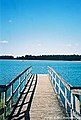 Fishing dock by a lake across near bike trails


References
- Notes
- Bibliography
- MTB Review, Trails.mtbr.com, 2006
- South Florida dot Com, Southflorida.com, 2006
25°53′11″N 80°16′43″W / 25.8862646°N 80.2786059°W / 25.8862646; -80.2786059
- v
- t
- e
- Downtown Miami
- Arts & Entertainment District
- Brickell
- Central Business District
- Historic District
- Government Center
- Park West
and universities
- Barry University
- Broward College
- Carlos Albizu University
- Florida Atlantic University
- Florida International University
- Florida Memorial University
- Johnson & Wales University
- Miami Dade College
- Miami International University of Art & Design
- Nova Southeastern University
- St. Thomas University
- University of Fort Lauderdale
- University of Miami
- Alice Wainwright Park
- Amelia Earhart Park
- Arch Creek
- The Barnacle Historic State Park
- Bayfront Park
- Big Cypress National Preserve
- Bill Baggs Cape Florida State Park
- Biscayne National Park
- Brian Piccolo Sports Park & Velodrome
- Chapman Field Park
- Crandon Park
- Dinner Key
- Everglades National Park
- Fairchild Tropical Botanic Garden
- Fort Dallas
- Fruit & Spice Park
- Greynolds Park
- Haulover Park
- Jungle Island
- The Kampong
- Margaret Pace Park
- Matheson Hammock Park
- Miami Seaquarium
- Monkey Jungle
- Museum Park
- Oleta River State Park
- Peacock Park
- Pride Park, Miami Beach FL
- Shark Valley
- Simpson Park Hammock
- South Pointe Park
- Tamiami Park
- Tropical Park
- The Underline
- Virginia Key
- Zoo Miami
- Adrienne Arsht Center for the Performing Arts
- Amerant Bank Arena
- Bass Museum
- Bergeron Rodeo Grounds
- Biltmore Hotel
- Bonita Chita Key
- Broward County Convention Center
- Butterfly World
- Coral Castle
- Downtown Miami
- FIU Stadium
- Florida Grand Opera
- Fontainebleau Miami Beach
- Fort Lauderdale Swap Shop
- Frost Art Museum
- Frost School of Music
- Gulfstream Park
- Hard Rock Stadium
- HistoryMiami
- Holocaust Memorial
- Homestead
- Jewish Museum of Florida
- Kaseya Center
- Las Olas Boulevard
- LoanDepot Park
- Lowe Art Museum
- Lincoln Road
- Lummus Park
- MacFarlane Homestead
- Miami Beach Architectural District
- Miami Beach Convention Center
- Miami Children's Museum
- Miami City Ballet
- Miami Conservatory
- Museum of Contemporary Art
- New World Symphony Orchestra
- Normandy Isles
- North Shore
- Ocean Bank Convocation Center
- Ocean Drive
- Phillip and Patricia Frost Museum of Science
- Pérez Art Museum Miami
- Riverwalk
- Seminole Hard Rock Hotel & Casino Hollywood
- South Beach
- The Miami Line
- Vizcaya Museum and Gardens
- Watsco Center
- Wolfsonian-FIU
- Wynwood Art District
- Aventura Mall
- Bal Harbour Shops
- Bayside Marketplace
- Boynton Beach Mall
- Brickell City Centre
- Broward Mall
- CocoWalk
- Coral Square
- Dadeland Mall
- Dolphin Mall
- The Falls
- The Galleria at Fort Lauderdale
- The Gardens Mall
- Lincoln Road
- The Mall at 163rd Street
- Mary Brickell Village
- Miami International Mall
- Midtown Miami
- Midway Crossings
- Miracle Marketplace
- Pembroke Lakes Mall
- The Promenade at Coconut Creek
- The Shops at Sunset Place
- Sawgrass Mills
- Southland Mall
- Shops at Merrick Park
- Town Center at Boca Raton
- Westland Mall
- Amtrak
- Broward County Transit
- Brightline
- Government Center
- Fort Lauderdale Executive Airport
- Fort Lauderdale–Hollywood International Airport
- Miami-Dade Transit
- Metrobus
- Metromover
- Metrorail
- MIA Mover
- MiamiCentral
- Miami Intermodal Center
- Miami International Airport
- Miami–Opa Locka Executive Airport
- North Perry Airport
- Palm Beach International Airport
- Palm Tran
- Pompano Beach Airpark
- Port Everglades
- PortMiami
- Tri-Rail
- East 6th Avenue
- North 36th Street
- North 54th Street
- North 79th Street
- North 103rd Street
- North 125th Street
- North 135th Street
- West 7th Avenue
- West 12th Avenue
- West 27th Avenue
- West 107th Avenue
- Allapattah Road
- Alton Road
- Bird Road
- Biscayne Boulevard
- Brickell Avenue
- Broad Causeway
- Collins Avenue
- Coral Reef Drive
- Coral Way
- County Line Road
- Douglas Road
- Flagler Street
- Galloway Road
- Gratigny
- Ives Dairy Road
- Julia Tuttle Causeway
- Kendall Drive
- John F. Kennedy Causeway
- Killian
- Krome Avenue
- William Lehman Causeway
- Le Jeune Road
- Ludlam Road
- MacArthur Causeway
- Miami Avenue
- Miami Gardens Drive
- Milam Dairy Road
- Miracle Mile
- Okeechobee Road
- Old Cutler Road
- Port Boulevard
- Quail Roost Drive
- Red Road
- Rickenbacker Causeway
- South Dixie Highway
- Sunset Drive
- Tamiami Trail
- University Drive
- Venetian Causeway
- West Dixie Highway
 WikiProject


