Brickell Avenue
Major street in Miami
 Brickell Avenue | |
|---|---|
 | |
| Route information | |
| Length | 1.8 mi[1] (2.9 km) |
| Existed | 1898 (1898)[2]–present |
| Major junctions | |
| South end |  US 1 (Dixie Highway) in Miami US 1 (Dixie Highway) in Miami |
| Major intersections |  US 41 in Miami US 41 in Miami |
| North end | US 1 (Biscayne Boulevard Way) in Miami |
| Location | |
| Country | United States |
| Counties | Miami-Dade |
| Highway system | |
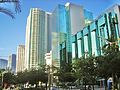
Brickell Avenue is a north–south road that is part of U.S. Route 1, in Miami, Florida, just south of the Miami River.[3] North of the Brickell Avenue Bridge, U.S. Route 1 is known as Biscayne Boulevard. Brickell Avenue is the main road through the Brickell financial district of Downtown Miami and is considered the Park Avenue of Florida.[citation needed] Brickell Avenue is lined with high-rise office buildings and residential condominiums, as well as many banks and restaurants. It is also famed for "Millionaire Row's" home to a cluster of Miami's most expensive residences.
It is a grid plan main north–south thoroughfare through the south part of Miami's central business district.
Route description
Brickell Avenue from the Miami River south it continues south-southwest and upon crossing Broadway/SE 15th Street it curves southwest and continues in that direction until it terminates at Southeast 26th Road/Rickenbacker Causeway, becoming South Federal Highway for a short distance (about 1/4 mile) until it becomes South Dixie Highway - US1. The portion north of the one-way pair of 7th and 8th Streets carries U.S. Route 41.
Major intersections
The entire route is in Miami, Miami-Dade County.
| mi[1] | km | Destinations | Notes | ||
|---|---|---|---|---|---|
| 0.0 | 0.0 |      US 1 south (Dixie Highway) / SR 913 (SE 26th Road) to I-95 north US 1 south (Dixie Highway) / SR 913 (SE 26th Road) to I-95 north | Access to tolled Rickenbacker Causeway via SR 913 east | ||
| 1.1 | 1.8 |   SR 972 west (SE 13th Street / Coral Way) SR 972 west (SE 13th Street / Coral Way) | Eastern terminus of SR 972 | ||
| 1.5 | 2.4 | US 41 west (SE 8th & 7th Streets) to I-95 | Eastern terminus of US 41 | ||
| 1.7 | 2.7 | Brickell Avenue Bridge over the Miami River | |||
| 1.8 | 2.9 |  US 1 north (SE 4th Street / Biscayne Boulevard Way) US 1 north (SE 4th Street / Biscayne Boulevard Way) | |||
| 1.000 mi = 1.609 km; 1.000 km = 0.621 mi | |||||
Notable attractions
Brickell's cultural significance has arguably surpassed downtown because its bar and restaurant zone brings in large crowds well into late night - early morning hours. Popular restaurants on Brickell Avenue include Komodo, La Petit Maison, Truluck's, and Cipriani. Many of its restaurants transform from bright, open restaurants during the day to inviting and sensual by night. Some of the places include Barsecco, Baby Jane Cocktail & Noodle Bar, and The Bar at Level 25.
There are also a few historic places on Brickell Avenue, including Brickell Mausoleum and Villa Serena, a home built on the former "Millioniare's Mile" for William Jennings Bryan, a former politician, in 1913.
Gallery
-
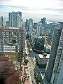 Aerial view of Brickell Avenue, as seen from the Viceroy Tower's skydeck
 -
-
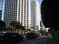
 Looking south
 -
 Looking north
 -


References
- ^ a b "Brickell Avenue" (Map). Google Maps. Retrieved January 1, 2020.
- ^ Arva Moore Parks; Sarah E. Eaton (June 17, 1997). George E. Nolan House, 1548 Brickell Avenue: Designation Report (PDF) (Report). City of Miami. p. 7. Archived from the original (PDF) on July 14, 2010. Retrieved November 18, 2012.
By the time the railroad arrived in 1896, spurred in part by the Brickells' gift of land to Henry Flagler, the Brickells had already paved a rock road, known as the Coconut Grove Trail, through their property. In 1898, the trail became a 145 foot wide roadway called Brickell Avenue and extended from the Miami River to Broadway (15th Road).
- ^ "Brickell Avenue Neighborhood Guide". Archived from the original on February 6, 2010. Retrieved February 4, 2010.
25°45′58″N 80°11′27″W / 25.766233°N 80.190711°W / 25.766233; -80.190711
- v
- t
- e
- Downtown Miami
- Arts & Entertainment District
- Brickell
- Central Business District
- Historic District
- Government Center
- Park West
and universities
- Barry University
- Broward College
- Carlos Albizu University
- Florida Atlantic University
- Florida International University
- Florida Memorial University
- Johnson & Wales University
- Miami Dade College
- Miami International University of Art & Design
- Nova Southeastern University
- St. Thomas University
- University of Fort Lauderdale
- University of Miami
- Alice Wainwright Park
- Amelia Earhart Park
- Arch Creek
- The Barnacle Historic State Park
- Bayfront Park
- Big Cypress National Preserve
- Bill Baggs Cape Florida State Park
- Biscayne National Park
- Brian Piccolo Sports Park & Velodrome
- Chapman Field Park
- Crandon Park
- Dinner Key
- Everglades National Park
- Fairchild Tropical Botanic Garden
- Fort Dallas
- Fruit & Spice Park
- Greynolds Park
- Haulover Park
- Jungle Island
- The Kampong
- Margaret Pace Park
- Matheson Hammock Park
- Miami Seaquarium
- Monkey Jungle
- Museum Park
- Oleta River State Park
- Peacock Park
- Pride Park, Miami Beach FL
- Shark Valley
- Simpson Park Hammock
- South Pointe Park
- Tamiami Park
- Tropical Park
- The Underline
- Virginia Key
- Zoo Miami
- Adrienne Arsht Center for the Performing Arts
- Amerant Bank Arena
- Bass Museum
- Bergeron Rodeo Grounds
- Biltmore Hotel
- Bonita Chita Key
- Broward County Convention Center
- Butterfly World
- Coral Castle
- Downtown Miami
- FIU Stadium
- Florida Grand Opera
- Fontainebleau Miami Beach
- Fort Lauderdale Swap Shop
- Frost Art Museum
- Frost School of Music
- Gulfstream Park
- Hard Rock Stadium
- HistoryMiami
- Holocaust Memorial
- Homestead
- Jewish Museum of Florida
- Kaseya Center
- Las Olas Boulevard
- LoanDepot Park
- Lowe Art Museum
- Lincoln Road
- Lummus Park
- MacFarlane Homestead
- Miami Beach Architectural District
- Miami Beach Convention Center
- Miami Children's Museum
- Miami City Ballet
- Miami Conservatory
- Museum of Contemporary Art
- New World Symphony Orchestra
- Normandy Isles
- North Shore
- Ocean Bank Convocation Center
- Ocean Drive
- Phillip and Patricia Frost Museum of Science
- Pérez Art Museum Miami
- Riverwalk
- Seminole Hard Rock Hotel & Casino Hollywood
- South Beach
- The Miami Line
- Vizcaya Museum and Gardens
- Watsco Center
- Wolfsonian-FIU
- Wynwood Art District
- Aventura Mall
- Bal Harbour Shops
- Bayside Marketplace
- Boynton Beach Mall
- Brickell City Centre
- Broward Mall
- CocoWalk
- Coral Square
- Dadeland Mall
- Dolphin Mall
- The Falls
- The Galleria at Fort Lauderdale
- The Gardens Mall
- Lincoln Road
- The Mall at 163rd Street
- Mary Brickell Village
- Miami International Mall
- Midtown Miami
- Midway Crossings
- Miracle Marketplace
- Pembroke Lakes Mall
- The Promenade at Coconut Creek
- The Shops at Sunset Place
- Sawgrass Mills
- Southland Mall
- Shops at Merrick Park
- Town Center at Boca Raton
- Westland Mall
- Amtrak
- Broward County Transit
- Brightline
- Government Center
- Fort Lauderdale Executive Airport
- Fort Lauderdale–Hollywood International Airport
- Miami-Dade Transit
- Metrobus
- Metromover
- Metrorail
- MIA Mover
- MiamiCentral
- Miami Intermodal Center
- Miami International Airport
- Miami–Opa Locka Executive Airport
- North Perry Airport
- Palm Beach International Airport
- Palm Tran
- Pompano Beach Airpark
- Port Everglades
- PortMiami
- Tri-Rail
- East 6th Avenue
- North 36th Street
- North 54th Street
- North 79th Street
- North 103rd Street
- North 125th Street
- North 135th Street
- West 7th Avenue
- West 12th Avenue
- West 27th Avenue
- West 107th Avenue
- Allapattah Road
- Alton Road
- Bird Road
- Biscayne Boulevard
- Brickell Avenue
- Broad Causeway
- Collins Avenue
- Coral Reef Drive
- Coral Way
- County Line Road
- Douglas Road
- Flagler Street
- Galloway Road
- Gratigny
- Ives Dairy Road
- Julia Tuttle Causeway
- Kendall Drive
- John F. Kennedy Causeway
- Killian
- Krome Avenue
- William Lehman Causeway
- Le Jeune Road
- Ludlam Road
- MacArthur Causeway
- Miami Avenue
- Miami Gardens Drive
- Milam Dairy Road
- Miracle Mile
- Okeechobee Road
- Old Cutler Road
- Port Boulevard
- Quail Roost Drive
- Red Road
- Rickenbacker Causeway
- South Dixie Highway
- Sunset Drive
- Tamiami Trail
- University Drive
- Venetian Causeway
- West Dixie Highway
 WikiProject
Wikimedia Commons has media related to Brickell Avenue.
 | This article relating to the United States Numbered Highway System is a stub. You can help Wikipedia by expanding it. |
- v
- t
- e
This article related to Miami is a stub. You can help Wikipedia by expanding it. |
- v
- t
- e


 Brickell_Avenue