National Register of Historic Places listings in Hays County, Texas
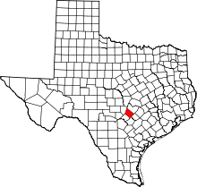
This is a list of the National Register of Historic Places listings in Hays County, Texas.
This is intended to be a complete list of properties and districts listed on the National Register of Historic Places in Hays County, Texas. There are eight districts and 49 individual properties listed on the National Register in the county. The individually listed properties include eight State Antiquities Landmarks and 23 Recorded Texas Historic Landmarks while two districts contains several more Recorded Texas Historic Landmarks.
This National Park Service list is complete through NPS recent listings posted September 13, 2024.[1]
Current listings
Map all coordinates using OpenStreetMap
Download coordinates as:
- KML
- GPX (all coordinates)
- GPX (primary coordinates)
- GPX (secondary coordinates)
The publicly disclosed locations of National Register properties and districts may be seen in a mapping service provided.[2]
| [3] | Name on the Register[4] | Image | Date listed[5] | Location | City or town | Description |
|---|---|---|---|---|---|---|
| 1 | Barber House |  | August 26, 1983 (#83004489) | 1000 Burleson St. 29°52′45″N 97°57′13″W / 29.87904°N 97.95365°W / 29.87904; -97.95365 (Barber House) | San Marcos | Historic Resources of San Marcos MRA |
| 2 | Belger-Cahill Lime Kiln |  | August 26, 1983 (#83004490) | Lime Kiln Rd. 29°53′59″N 97°55′35″W / 29.899722°N 97.926389°W / 29.899722; -97.926389 (Belger-Cahill Lime Kiln) | San Marcos | Historic Resources of San Marcos MRA |
| 3 | Belvin Street Historic District |  | December 1, 1983 (#83003792) | 700, 800, 900 blocks of Belvin St., and 227 Mitchell St. 29°52′44″N 97°57′03″W / 29.878889°N 97.950833°W / 29.878889; -97.950833 (Belvin Street Historic District) | San Marcos | Includes Recorded Texas Historic Landmarks; Historic Resources of San Marcos MRA |
| 4 | Bunton Branch Bridge | 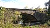 | February 19, 2002 (#02000086) | Cty. Rd. 210, approx. 0.2 mi (0.32 km). NW of jct. with IH-35 at Bunton Overpass 30°01′05″N 97°51′31″W / 30.018056°N 97.858611°W / 30.018056; -97.858611 (Bunton Branch Bridge) | Kyle | State Antiquities Landmark, Recorded Texas Historic Landmark |
| 5 | Burleson-Knispel House | Upload image | August 3, 1979 (#79002975) | 1.5 mi (2.4 km). N of San Marcos on Lime Kiln Rd 29°54′43″N 97°55′43″W / 29.911944°N 97.928611°W / 29.911944; -97.928611 (Burleson-Knispel House) | San Marcos | Recorded Texas Historic Landmark |
| 6 | Caldwell House |  | August 26, 1983 (#83004491) | 619 Maury St. 29°53′00″N 97°57′05″W / 29.883333°N 97.951389°W / 29.883333; -97.951389 (Caldwell House) | San Marcos | Historic Resources of San Marcos MRA |
| 7 | Camp Ben McCulloch |  | October 12, 2004 (#04001151) | 18301 Ranch Rd. 1826 30°07′45″N 98°00′52″W / 30.129167°N 98.014444°W / 30.129167; -98.014444 (Camp Ben McCulloch) | Driftwood | |
| 8 | Cape House |  | August 26, 1983 (#83004492) | 316 W. Hopkins St. 29°52′59″N 97°56′40″W / 29.8830°N 97.9445°W / 29.8830; -97.9445 (Cape House) | San Marcos | Recorded Texas Historic Landmark; Historic Resources of San Marcos MRA |
| 9 | Cemetery Chapel, San Marcos Cemetery |  | December 1, 1983 (#83003793) | TX 12 29°53′12″N 97°57′27″W / 29.88676°N 97.9576°W / 29.88676; -97.9576 (Cemetery Chapel, San Marcos Cemetery) | San Marcos | Recorded Texas Historic Landmark; Historic Resources of San Marcos MRA |
| 10 | Cen-Tex Wool Mill Historic District |  | June 1, 2005 (#05000520) | 101 Uhland Rd. 29°54′02″N 97°54′59″W / 29.900556°N 97.916389°W / 29.900556; -97.916389 (Cen-Tex Wool Mill Historic District) | San Marcos | |
| 11 | Cock House |  | April 2, 1973 (#73001966) | 400 E. Hopkins St. 29°53′00″N 97°56′14″W / 29.88335°N 97.93725°W / 29.88335; -97.93725 (Cock House) | San Marcos | State Antiquities Landmark, Recorded Texas Historic Landmark |
| 12 | John R. Dobie House |  | August 18, 1992 (#92001024) | 282 Old Kyle Rd. 29°59′48″N 98°05′34″W / 29.996667°N 98.092778°W / 29.996667; -98.092778 (John R. Dobie House) | Wimberley | Recorded Texas Historic Landmark |
| 13 | Cora Jackman Donalson House |  | October 28, 2010 (#10000864) | 200 S. Sledge St. 29°59′18″N 97°52′47″W / 29.9883°N 97.8798°W / 29.9883; -97.8798 (Cora Jackman Donalson House) | Kyle | Recorded Texas Historic Landmark; Rural Properties of Hays County, Texas MPS |
| 14 | Downtown Buda Historic District | 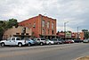 | November 7, 2003 (#03001126) | Roughly bounded by Elm St., Main St., China St., and Austin St. 30°04′54″N 97°50′36″W / 30.0818°N 97.8432°W / 30.0818; -97.8432 (Downtown Buda Historic District) | Buda | |
| 15 | Dripping Springs Downtown Historic District |  | July 17, 2013 (#13000504) | 100-500 blk. Mercer, 100 blk. Wallace, 100 blk. San Marcos & 101 College Sts., 101-103 Old Fitzhugh Rd. 30°11′34″N 98°05′21″W / 30.19281°N 98.0892°W / 30.19281; -98.0892 (Dripping Springs Downtown Historic District) | Dripping Springs | Includes Recorded Texas Historic Landmarks |
| 16 | Episcopalian Rectory |  | August 26, 1983 (#83004493) | 225 W. Hopkins St. 29°52′57″N 97°56′37″W / 29.8826°N 97.9436°W / 29.8826; -97.9436 (Episcopalian Rectory) | San Marcos | Historic Resources of San Marcos MRA |
| 17 | Farmers Union Gin Company | 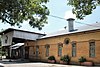 | August 26, 1983 (#83004494) | 120 Grove St. 29°52′33″N 97°56′25″W / 29.875833°N 97.940278°W / 29.875833; -97.940278 (Farmers Union Gin Company) | San Marcos | Recorded Texas Historic Landmark; Historic Resources of San Marcos MRA |
| 18 | Fire Station and City Hall |  | August 26, 1983 (#83004495) | 224 N. Guadalupe St. 29°53′02″N 97°56′28″W / 29.883889°N 97.941111°W / 29.883889; -97.941111 (Fire Station and City Hall) | San Marcos | Historic Resources of San Marcos MRA |
| 19 | First United Methodist Church |  | November 8, 1974 (#74002269) | 129 W. Hutchison 29°53′02″N 97°56′34″W / 29.883889°N 97.942778°W / 29.883889; -97.942778 (First United Methodist Church) | San Marcos | Recorded Texas Historic Landmark |
| 20 | Fisher Hall | Upload image | August 26, 1983 (#83004496) | 1132 Belvin St. 29°52′35″N 97°57′16″W / 29.876389°N 97.954444°W / 29.876389; -97.954444 (Fisher Hall) | San Marcos | Recorded Texas Historic Landmark; Historic Resources of San Marcos MRA; destroyed by fire in 2007[6] |
| 21 | Fort Street Presbyterian Church |  | March 23, 1984 (#84001860) | 516 W. Hopkins St. 29°52′55″N 97°56′48″W / 29.8819°N 97.9467°W / 29.8819; -97.9467 (Fort Street Presbyterian Church) | San Marcos | Recorded Texas Historic Landmark; Historic Resources of San Marcos MRA |
| 22 | Four Winns Ranch | Upload image | May 29, 2018 (#100002472) | 234 & 236 Winn Valley Dr. 29°58′16″N 98°06′29″W / 29.971042°N 98.108103°W / 29.971042; -98.108103 (Four Winns Ranch) | Wimberley | |
| 23 | Harry Freeman Site |  | November 7, 1978 (#78002953) | Address restricted[7] | San Marcos | |
| 24 | Goforth-Harris House |  | August 26, 1983 (#83004497) | 401 Comanche St. 29°53′06″N 97°56′40″W / 29.885°N 97.944444°W / 29.885; -97.944444 (Goforth-Harris House) | San Marcos | Recorded Texas Historic Landmark; Historic Resources of San Marcos MRA |
| 25 | Isham Jones Good Homestead |  | August 20, 2004 (#04000896) | 13401 Evergreen Way 30°10′09″N 97°57′43″W / 30.169167°N 97.961944°W / 30.169167; -97.961944 (Isham Jones Good Homestead) | Austin | |
| 26 | Green and Faris Buildings |  | August 26, 1983 (#83004498) | 136-144 E. San Antonio St. 29°52′56″N 97°56′25″W / 29.8821°N 97.9402°W / 29.8821; -97.9402 (Green and Faris Buildings) | San Marcos | Historic Resources of San Marcos MRA; part of Hays County Courthouse Historic District |
| 27 | Hardy-Williams Building |  | August 26, 1983 (#83004499) | 127 E. Hopkins St. 29°53′00″N 97°56′27″W / 29.8833°N 97.9407°W / 29.8833; -97.9407 (Hardy-Williams Building) | San Marcos | Historic Resources of San Marcos MRA; part of Hays County Courthouse Historic District |
| 28 | Hays County Courthouse |  | May 23, 1980 (#80004134) | Public Sq. 29°52′56″N 97°56′25″W / 29.882222°N 97.940278°W / 29.882222; -97.940278 (Hays County Courthouse) | San Marcos | State Antiquities Landmark; part of Hays County Courthouse Historic District |
| 29 | Hays County Courthouse Historic District |  | September 10, 1992 (#92001233) | Roughly bounded by the alleys behind N. Guadalupe, E. Hopkins, N. LBJ and E. San Antonio Sts. 29°52′57″N 97°56′25″W / 29.8825°N 97.940278°W / 29.8825; -97.940278 (Hays County Courthouse Historic District) | San Marcos | Historic Resources of San Marcos MRA |
| 30 | Hays County Jail |  | August 26, 1983 (#83004500) | 170 S Fredericksburg St. 29°52′50″N 97°56′33″W / 29.88042°N 97.9424°W / 29.88042; -97.9424 (Hays County Jail) | San Marcos | State Antiquities Landmark; Historic Resources of San Marcos MRA |
| 31 | Heard House |  | August 26, 1983 (#83004501) | 620 W. San Antonio St. 29°52′46″N 97°56′48″W / 29.879444°N 97.946667°W / 29.879444; -97.946667 (Heard House) | San Marcos | Recorded Texas Historic Landmark; Historic Resources of San Marcos MRA |
| 32 | Augusta Hofheinz House | 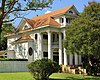 | August 26, 1983 (#83004502) | 1104 W. Hopkins St. 29°52′35″N 97°57′10″W / 29.8764°N 97.95275°W / 29.8764; -97.95275 (Augusta Hofheinz House) | San Marcos | Recorded Texas Historic Landmark; Historic Resources of San Marcos MRA |
| 33 | Walter Hofheinz House |  | December 1, 1983 (#83003794) | 819 W. Hopkins St. 29°52′42″N 97°57′00″W / 29.87835°N 97.94993°W / 29.87835; -97.94993 (Walter Hofheinz House) | San Marcos | Historic Resources of San Marcos MRA |
| 34 | Hutchison House |  | August 26, 1983 (#83004503) | LBJ Dr. and University St. 29°53′08″N 97°56′25″W / 29.88565°N 97.9403°W / 29.88565; -97.9403 (Hutchison House) | San Marcos | Recorded Texas Historic Landmark; Historic Resources of San Marcos MRA |
| 35 | Johnson House |  | August 26, 1983 (#83004504) | 1030 Belvin St. 29°52′37″N 97°57′12″W / 29.876944°N 97.953333°W / 29.876944; -97.953333 (Johnson House) | San Marcos | Recorded Texas Historic Landmark; Historic Resources of San Marcos MRA |
| 36 | Kone-Cliett House |  | December 1, 1983 (#83003795) | 724 Burleson St. 29°52′52″N 97°57′05″W / 29.88116°N 97.9513°W / 29.88116; -97.9513 (Kone-Cliett House) | San Marcos | Recorded Texas Historic Landmark; Historic Resources of San Marcos MRA |
| 37 | Kyle City Hall | 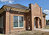 | May 22, 2002 (#02000528) | 109 Burleson Rd. 29°59′18″N 97°52′37″W / 29.988333°N 97.876944°W / 29.988333; -97.876944 (Kyle City Hall) | Kyle | State Antiquities Landmark; Rural Properties of Hays County, Texas MPS |
| 38 | Claiborne Kyle Log House |  | May 28, 1981 (#81000630) | SW of Kyle 29°57′55″N 97°54′08″W / 29.965278°N 97.902222°W / 29.965278; -97.902222 (Claiborne Kyle Log House) | Kyle vicinity | State Antiquities Landmark, Recorded Texas Historic Landmark |
| 39 | James C. Lane House |  | November 29, 2010 (#10000961) | 306 Wimberley Square 29°59′43″N 98°05′51″W / 29.995278°N 98.0975°W / 29.995278; -98.0975 (James C. Lane House) | Wimberley | Recorded Texas Historic Landmark; Rural Properties of Hays County, Texas MPS |
| 40 | Main Building, Southwest Texas Normal School | 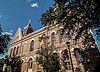 | August 26, 1983 (#83004505) | Old Main St., Texas State University 29°53′21″N 97°56′19″W / 29.889167°N 97.938611°W / 29.889167; -97.938611 (Main Building, Southwest Texas Normal School) | San Marcos | State Antiquities Landmark, Recorded Texas Historic Landmark; Historic Resources of San Marcos MRA; 1903 Victorian Gothic building designed by Edward Northcraft; first building of the Southwest Texas State Normal School (now known as Texas State University)[8] |
| 41 | McKie-Bass Building |  | December 1, 1983 (#83003797) | 111 N. Guadalupe St. 29°52′57″N 97°56′29″W / 29.8825°N 97.9415°W / 29.8825; -97.9415 (McKie-Bass Building) | San Marcos | Historic Resources of San Marcos MRA; part of Hays County Courthouse Historic District |
| 42 | M.G. Michaelis Ranch |  | March 7, 2003 (#02001212) | 3600 FM 150 West 30°01′42″N 97°55′24″W / 30.0284°N 97.923217°W / 30.0284; -97.923217 (M.G. Michaelis Ranch) | Kyle | Rural Properties of Hays County, Texas MPS |
| 43 | Moore Grocery Company | 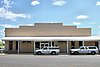 | August 26, 1983 (#83004506) | 101 S. Edward Gary St. 29°52′56″N 97°56′18″W / 29.8821°N 97.9384°W / 29.8821; -97.9384 (Moore Grocery Company) | San Marcos | Historic Resources of San Marcos MRA |
| 44 | Ruskin C. Norman Site (41 HY 86) | | November 21, 1978 (#78002954) | Address restricted[7] | San Marcos | |
| 45 | Onion Creek Post Office and Stagecoach House |  | October 27, 2002 (#02001211) | 109 N. Loop 4 30°05′23″N 97°50′13″W / 30.089722°N 97.836944°W / 30.089722; -97.836944 (Onion Creek Post Office and Stagecoach House) | Buda | State Antiquities Landmark, Recorded Texas Historic Landmark; Rural Properties of Hays County, Texas MPS |
| 46 | Pettey House |  | June 20, 2008 (#08000541) | 714 Burleson St. 29°52′53″N 97°57′03″W / 29.8813°N 97.9509°W / 29.8813; -97.9509 (Pettey House) | San Marcos | Historic Resources of San Marcos MRA |
| 47 | Katherine Anne Porter House | 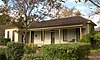 | August 20, 2004 (#04000893) | 508 W. Center St. 29°59′22″N 97°52′49″W / 29.989444°N 97.880278°W / 29.989444; -97.880278 (Katherine Anne Porter House) | Kyle | Rural Properties of Hays County, Texas MPS |
| 48 | Dr. Joseph M. and Sarah Pound Farmstead | 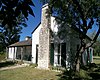 | July 28, 1995 (#95000929) | Ranch Rd. 12 N. 30°12′02″N 98°04′50″W / 30.200556°N 98.080556°W / 30.200556; -98.080556 (Dr. Joseph M. and Sarah Pound Farmstead) | Dripping Springs | |
| 49 | Ragsdale-Jackman-Yarbough House |  | August 26, 1983 (#83004507) | 621 W. San Antonio St. 29°52′45″N 97°56′47″W / 29.8791°N 97.9464°W / 29.8791; -97.9464 (Ragsdale-Jackman-Yarbough House) | San Marcos | Recorded Texas Historic Landmark; Historic Resources of San Marcos MRA |
| 50 | Rylander-Kyle House |  | August 26, 1983 (#83004508) | 711 W. San Antonio St. 29°52′43″N 97°56′49″W / 29.8787°N 97.9470°W / 29.8787; -97.9470 (Rylander-Kyle House) | San Marcos | Recorded Texas Historic Landmark; Historic Resources of San Marcos MRA |
| 51 | San Marcos Colored School Home Economics Building | Upload image | September 9, 2024 (#100010800) | 801 W. Martin Luther King Drive 29°52′35″N 97°56′50″W / 29.8765°N 97.9471°W / 29.8765; -97.9471 (San Marcos Colored School Home Economics Building) | San Marcos | |
| 52 | San Marcos Milling Company | 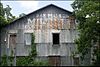 | December 1, 1983 (#83003799) | Nicola Alley 29°52′33″N 97°56′18″W / 29.875833°N 97.938333°W / 29.875833; -97.938333 (San Marcos Milling Company) | San Marcos | Historic Resources of San Marcos MRA |
| 53 | San Marcos Telephone Company |  | August 26, 1983 (#83004509) | 138 W. San Antonio St. 29°52′56″N 97°56′32″W / 29.882222°N 97.942361°W / 29.882222; -97.942361 (San Marcos Telephone Company) | San Marcos | Historic Resources of San Marcos MRA. Demolished in 2019.[9] |
| 54 | Simon Building |  | August 26, 1983 (#83004510) | 124-126 W. Hopkins St. 29°52′59″N 97°56′32″W / 29.8831°N 97.9422°W / 29.8831; -97.9422 (Simon Building) | San Marcos | Historic Resources of San Marcos MRA |
| 55 | Smith House |  | August 26, 1983 (#83004511) | 322 Scott St. 29°52′53″N 97°56′59″W / 29.88143°N 97.94984°W / 29.88143; -97.94984 (Smith House) | San Marcos | Historic Resources of San Marcos MRA |
| 56 | Williams-Tarbutton House |  | August 26, 1983 (#83004512) | 626 Lindsey St. 29°52′57″N 97°57′04″W / 29.8826°N 97.9511°W / 29.8826; -97.9511 (Williams-Tarbutton House) | San Marcos | Historic Resources of San Marcos MRA |
| 57 | Winters-Wimberley House |  | May 22, 2002 (#02000527) | 14070 Ranch Road 12 29°59′53″N 98°05′54″W / 29.998056°N 98.098333°W / 29.998056; -98.098333 (Winters-Wimberley House) | Wimberley | Rural Properties of Hays County, Texas MPS |
Former listings
| [3] | Name on the Register | Image | Date listed | Date removed | Location | City or town | Description |
|---|---|---|---|---|---|---|---|
| 1 | Negro School | Upload image | March 23, 1984 (#84001868) | September 28, 1987 | Comal and Endicott Sts. | San Marcos | Historic Resources of San Marcos MRA. Also known as Dunbar School. |
See also
 National Register of Historic Places portal
 Texas portal


- National Register of Historic Places listings in Texas
- Recorded Texas Historic Landmarks in Hays County
References
- ^ National Park Service, United States Department of the Interior, "National Register of Historic Places: Weekly List Actions", retrieved September 13, 2024.
- ^ The latitude and longitude information provided in this table was derived originally from the National Register Information System, which has been found to be fairly accurate for about 99% of listings. Some locations in this table may have been corrected to current GPS standards.
- ^ a b Numbers represent an alphabetical ordering by significant words. Various colorings, defined here, differentiate National Historic Landmarks and historic districts from other NRHP buildings, structures, sites or objects.
- ^ "National Register Information System". National Register of Historic Places. National Park Service. July 9, 2010.
- ^ The eight-digit number below each date is the number assigned to each location in the National Register Information System database, which can be viewed by clicking the number.
- ^ "Man who burned old hospital serving eight years probation | San Marcos Mercury | Local News from San Marcos and Hays County, Texas". Archived from the original on May 8, 2014.
{{cite web}}: CS1 maint: unfit URL (link) - ^ a b Federal and state laws and practices restrict general public access to information regarding the specific location of this resource. In some cases, this is to protect archeological sites from vandalism, while in other cases it is restricted at the request of the owner. See: Knoerl, John; Miller, Diane; Shrimpton, Rebecca H. (1990), Guidelines for Restricting Information about Historic and Prehistoric Resources, National Register Bulletin, National Park Service, U.S. Department of the Interior, OCLC 20706997.
- ^ "Old Main". San Marcos, Texas: Texas State University. Retrieved September 3, 2013.
- ^ ""San Marcos is Losing History": Residents React to Building Demolition".
External links
![]() Media related to National Register of Historic Places in Hays County, Texas at Wikimedia Commons
Media related to National Register of Historic Places in Hays County, Texas at Wikimedia Commons
- v
- t
- e
Places adjacent to National Register of Historic Places listings in Hays County, Texas
| Blanco County | Travis County | |
 | ||
 Hays County, Texas Hays County, Texas | ||
 | ||
| Comal County | Guadalupe County | Caldwell County |

Municipalities and communities of Hays County, Texas, United States | ||
|---|---|---|
County seat: San Marcos | ||
| Cities |  | |
| Village | ||
| CDPs | ||
| Ghost town | ||
| Footnotes | ‡This populated place also has portions in an adjacent county or counties | |
| ||


