National Register of Historic Places listings in Cameron County, Texas

This is a list of the National Register of Historic Places listings in Cameron County, Texas.
This is intended to be a complete list of properties and districts listed on the National Register of Historic Places in Cameron County, Texas, United States. The publicly disclosed locations of National Register properties and districts may be seen in a mapping service provided.[1] There are 35 properties and districts listed on the National Register in the county, including 4 National Historic Landmarks. Another property that was formerly listed has been removed.
This National Park Service list is complete through NPS recent listings posted September 13, 2024.[2]
Map all coordinates using OpenStreetMap
Download coordinates as:
- KML
- GPX (all coordinates)
- GPX (primary coordinates)
- GPX (secondary coordinates)
Current listings
| [3] | Name on the Register[4] | Image | Date listed[5] | Location | City or town | Description |
|---|---|---|---|---|---|---|
| 1 | Baxter Building |  | March 6, 2019 (#100003420) | 106 S. A St. 26°11′33″N 97°41′49″W / 26.192451°N 97.696836°W / 26.192451; -97.696836 (Baxter Building) | Harlingen | |
| 2 | Brazos Santiago Depot | Upload image | July 14, 1971 (#71000923) | Address restricted[6] | Port Isabel | |
| 3 | Samuel Wallace Brooks House |  | November 22, 1988 (#88002530) | 623 E St. Charles St. 25°54′14″N 97°30′12″W / 25.90375°N 97.503472°W / 25.90375; -97.503472 (Samuel Wallace Brooks House) | Brownsville | |
| 4 | Brown-Wagner House |  | August 29, 1977 (#77001430) | 245 E St. Charles St. 25°54′23″N 97°30′22″W / 25.90625°N 97.506042°W / 25.90625; -97.506042 (Brown-Wagner House) | Brownsville | Recorded Texas Historic Landmark |
| 5 | Brownsville City Cemetery and Hebrew Cemetery |  | March 31, 2010 (#10000143) | Bound by E. 5th St., Madison St., E 2nd St., and Town Resaca 25°54′34″N 97°30′00″W / 25.909514°N 97.5°W / 25.909514; -97.5 (Brownsville City Cemetery and Hebrew Cemetery) | Brownsville | |
| 6 | Brownsville City Hall and Market House |  | September 30, 2019 (#100004474) | 1150 Market Square 25°54′08″N 97°29′51″W / 25.902356°N 97.497521°W / 25.902356; -97.497521 (Brownsville City Hall and Market House) | Brownsville | |
| 7 | Brownsville Freight Depot and Warehouse District |  | March 26, 2018 (#100002266) | Roughly bounded by former RR alignment, E Fronton, E 4th & E 9th Sts. 25°54′09″N 97°30′22″W / 25.902504°N 97.506088°W / 25.902504; -97.506088 (Brownsville Freight Depot and Warehouse District) | Brownsville | |
| 8 | Old Brulay Plantation | Upload image | October 10, 1975 (#75001961) | East of Brownsville off of TX 4 25°51′16″N 97°24′01″W / 25.854531°N 97.400289°W / 25.854531; -97.400289 (Old Brulay Plantation) | Brownsville | Also known as the Nye Plantation[7] |
| 9 | Cameron County Courthouse |  | September 27, 1980 (#80004084) | 1150 E Madison St. 25°54′15″N 97°29′43″W / 25.904167°N 97.495347°W / 25.904167; -97.495347 (Cameron County Courthouse) | Brownsville | State Antiquities Landmark, Recorded Texas Historic Landmark |
| 10 | Old Cameron County Jail |  | January 24, 1995 (#94001594) | 1201 E Van Buren 25°54′19″N 97°29′34″W / 25.905278°N 97.492847°W / 25.905278; -97.492847 (Old Cameron County Jail) | Brownsville | Recorded Texas Historic Landmark |
| 11 | Augustine Celaya House |  | April 11, 1986 (#86000726) | 504 E St. Francis St. 25°54′13″N 97°30′19″W / 25.903681°N 97.505347°W / 25.903681; -97.505347 (Augustine Celaya House) | Brownsville | Recorded Texas Historic Landmark |
| 12 | Celaya-Creager House |  | May 5, 1988 (#88000523) | 441 E Washington St. 25°54′25″N 97°30′09″W / 25.906806°N 97.5025°W / 25.906806; -97.5025 (Celaya-Creager House) | Brownsville | |
| 13 | Central Brownsville Historic District | Upload image | May 31, 2019 (#100004008) | Roughly bounded by E. Levee, E. 10th, E. Monroe, E. 14th & E. 15th Sts. & 2 blk. extension along 800 & 900 blks. of E. Elizabeth St. 25°54′10″N 97°29′51″W / 25.9029°N 97.4975°W / 25.9029; -97.4975 (Central Brownsville Historic District) | Brownsville | |
| 14 | Lillian and George K. Aziz Essey House | Upload image | September 8, 2021 (#100006889) | 1205 West Elizabeth St. 25°55′03″N 97°30′57″W / 25.9175°N 97.5157°W / 25.9175; -97.5157 (Lillian and George K. Aziz Essey House) | Brownsville | |
| 15 | Fernandez and Laiseca Building | Upload image | May 11, 2018 (#100002433) | 1142-1154 Madison St. 25°54′13″N 97°29′44″W / 25.903539°N 97.495647°W / 25.903539; -97.495647 (Fernandez and Laiseca Building) | Brownsville | |
| 16 | Miguel Fernandez Hide Yard | 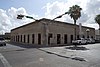 | October 1, 1990 (#90001485) | 1101-1121 E Adams St. 25°54′11″N 97°29′51″W / 25.902947°N 97.497414°W / 25.902947; -97.497414 (Miguel Fernandez Hide Yard) | Brownsville | also known as El Aleman |
| 17 | Fort Brown | 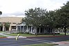 | October 15, 1966 (#66000811) | S edge of Brownsville off of International Blvd. 25°53′50″N 97°29′26″W / 25.897222°N 97.490556°W / 25.897222; -97.490556 (Fort Brown) | Brownsville | |
| 18 | M.E. and Estela Cueto Garcia House |  | June 5, 2017 (#100001038) | 155 Calle Anacua 25°55′01″N 97°30′11″W / 25.916861°N 97.503116°W / 25.916861; -97.503116 (M.E. and Estela Cueto Garcia House) | Brownsville | |
| 19 | Garcia Pasture Site | Upload image | February 23, 1972 (#72001355) | Address restricted[6] | Port Isabel | |
| 20 | The Gem |  | June 28, 1991 (#91000852) | 400 E 13th St. 25°54′00″N 97°29′52″W / 25.89989°N 97.49768°W / 25.89989; -97.49768 (The Gem) | Brownsville | Recorded Texas Historic Landmark |
| 21 | Cieta Friedman and Harry W. Hollowell House | Upload image | March 25, 2019 (#100003533) | 622 E. Saint Charles St. 25°54′13″N 97°30′14″W / 25.903495°N 97.503767°W / 25.903495; -97.503767 (Cieta Friedman and Harry W. Hollowell House) | Brownsville | |
| 22 | Hicks-Gregg House |  | July 1, 2009 (#09000486) | 1249 W. Washington 25°55′06″N 97°30′56″W / 25.918375°N 97.515536°W / 25.918375; -97.515536 (Hicks-Gregg House) | Brownsville | Recorded Texas Historic Landmark |
| 23 | Immaculate Conception Church |  | March 26, 1980 (#80004085) | 1218 E Jefferson St. 25°54′09″N 97°29′45″W / 25.9025°N 97.495972°W / 25.9025; -97.495972 (Immaculate Conception Church) | Brownsville | Recorded Texas Historic Landmark |
| 24 | La Madrilena | 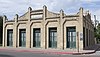 | November 17, 1988 (#88002384) | 1002 E Madison 25°54′17″N 97°29′49″W / 25.904722°N 97.496806°W / 25.904722; -97.496806 (La Madrilena) | Brownsville | Recorded Texas Historic Landmark |
| 25 | Manautou House |  | July 14, 1983 (#83003130) | 5 E Elizabeth St. 25°54′33″N 97°30′23″W / 25.909236°N 97.506458°W / 25.909236; -97.506458 (Manautou House) | Brownsville | Recorded Texas Historic Landmark |
| 26 | McNair House |  | November 24, 2015 (#15000836) | 39 Sunset Drive 25°55′08″N 97°29′52″W / 25.918960°N 97.497848°W / 25.918960; -97.497848 (McNair House) | Brownsville | Recorded Texas Historic Landmark |
| 27 | Morris-Browne House |  | October 25, 2006 (#06000955) | 204 E Levee St. 25°54′25″N 97°30′22″W / 25.90695°N 97.506111°W / 25.90695; -97.506111 (Morris-Browne House) | Brownsville | |
| 28 | La Nueva Libertad |  | April 11, 1986 (#84001628) | 1301 E Madison 25°54′10″N 97°29′40″W / 25.902778°N 97.494375°W / 25.902778; -97.494375 (La Nueva Libertad) | Brownsville | Recorded Texas Historic Landmark; also known as the Cueto Building |
| 29 | Palmito Ranch Battlefield |  | October 15, 1996 (#93000266) | Between TX 4 and the Rio Grande, 12 mi. E of Brownsville 25°56′48″N 97°17′07″W / 25.946667°N 97.285278°W / 25.946667; -97.285278 (Palmito Ranch Battlefield) | Brownsville | |
| 30 | Palmville | Upload image | October 20, 2021 (#100007077) | 1400 North Reagan St. 26°08′29″N 97°37′18″W / 26.1415°N 97.6216°W / 26.1415; -97.6216 (Palmville) | San Benito | |
| 31 | Palo Alto Battlefield National Historical Park |  | October 15, 1966 (#66000812) | 6.3 miles N of Brownsville at intersection of FM 1847 and FM 511 26°01′04″N 97°28′50″W / 26.017886°N 97.480617°W / 26.017886; -97.480617 (Palo Alto Battlefield National Historical Park) | Brownsville | |
| 32 | Point Isabel Lighthouse | 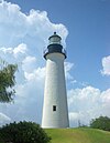 | April 30, 1976 (#76002014) | Corner of TX 100 and Garcia St. 26°04′39″N 97°12′27″W / 26.077633°N 97.207583°W / 26.077633; -97.207583 (Point Isabel Lighthouse) | Port Isabel | State Antiquities Landmark |
| 33 | Resaca de la Palma Battlefield |  | April 11, 1986 (#66000813) | North of intersection of Paredes Line Rd and Price Rd. 25°56′15″N 97°29′10″W / 25.9375°N 97.486111°W / 25.9375; -97.486111 (Resaca de la Palma Battlefield) | Brownsville | Now a portion of the Palo Alto Battlefield National Historical Park |
| 34 | Rio Grande Valley Gas Company Building | Upload image | August 8, 2022 (#100007983) | 355 West Elizabeth St. 25°54′42″N 97°30′35″W / 25.911679°N 97.509743°W / 25.911679; -97.509743 (Rio Grande Valley Gas Company Building) | Brownsville | |
| 35 | Southern Pacific Railroad Passenger Depot |  | November 17, 1978 (#78002903) | 601 E Madison St. 25°54′27″N 97°29′57″W / 25.9075°N 97.499236°W / 25.9075; -97.499236 (Southern Pacific Railroad Passenger Depot) | Brownsville | Recorded Texas Historic Landmark |
| 36 | Charles Stillman House |  | November 19, 1979 (#79003448) | 1305 E Washington St. 25°54′03″N 97°29′47″W / 25.900833°N 97.496319°W / 25.900833; -97.496319 (Charles Stillman House) | Brownsville | Recorded Texas Historic Landmark |
Former listing
| [3] | Name on the Register | Image | Date listed | Date removed | Location | City or town | Description |
|---|---|---|---|---|---|---|---|
| 1 | USS Cabot |  | June 21, 1990 (#90000334) | August 7, 2001 | Port of Brownsville 25°57′03″N 97°24′39″W / 25.950835°N 97.410844°W / 25.950835; -97.410844 (USS Cabot) | Brownsville | Previously berthed in New Orleans until 1999; scrapped in 2002 |
See also
Wikimedia Commons has media related to National Register of Historic Places in Cameron County, Texas.
 National Register of Historic Places portal
 Texas portal


- National Register of Historic Places listings in Texas
- List of National Historic Landmarks in Texas
- Recorded Texas Historic Landmarks in Cameron County
References
- ^ The latitude and longitude information provided in this table was derived originally from the National Register Information System, which has been found to be fairly accurate for about 99% of listings. Some locations in this table may have been corrected to current GPS standards.
- ^ National Park Service, United States Department of the Interior, "National Register of Historic Places: Weekly List Actions", retrieved September 13, 2024.
- ^ a b Numbers represent an alphabetical ordering by significant words. Various colorings, defined here, differentiate National Historic Landmarks and historic districts from other NRHP buildings, structures, sites or objects.
- ^ "National Register Information System". National Register of Historic Places. National Park Service. July 9, 2010.
- ^ The eight-digit number below each date is the number assigned to each location in the National Register Information System database, which can be viewed by clicking the number.
- ^ a b Federal and state laws and practices restrict general public access to information regarding the specific location of this resource. In some cases, this is to protect archeological sites from vandalism, while in other cases it is restricted at the request of the owner. See: Knoerl, John; Miller, Diane; Shrimpton, Rebecca H. (1990), Guidelines for Restricting Information about Historic and Prehistoric Resources, National Register Bulletin, National Park Service, U.S. Department of the Interior, OCLC 20706997.
- ^ http://www.advancedmastergardener.org/Section106/Brulay%20Plantation%20Historical%20Study/Brulay.pdf [bare URL PDF]
- v
- t
- e
Places adjacent to National Register of Historic Places listings in Cameron County, Texas
| Willacy County | ||
 | ||
| Hidalgo County |  Cameron County, Texas Cameron County, Texas | Gulf of Mexico |
 | ||
| Matamoros, Tamaulipas, Mexico |

Municipalities and communities of Cameron County, Texas, United States | ||
|---|---|---|
County seat: Brownsville | ||
| Cities |  | |
| Towns | ||
| Village | ||
| CDPs |
| |
| Other communities | ||
| Ghost towns |
| |
| ||


