National Register of Historic Places listings in Brewster County, Texas

This is a list of the National Register of Historic Places listings in Brewster County, Texas
This is intended to be a complete list of properties and districts listed on the National Register of Historic Places in Brewster County, Texas. There are seven districts and five individual properties listed on the National Register in the county. Two sites are also listed as Recorded Texas Historic Landmarks including one that is a State Antiquities Landmark.
This National Park Service list is complete through NPS recent listings posted September 13, 2024.[1]
Current listings
Map all coordinates using OpenStreetMap
Download coordinates as:
- KML
- GPX (all coordinates)
- GPX (primary coordinates)
- GPX (secondary coordinates)
The publicly disclosed locations of National Register properties and districts may be seen in a mapping service provided.[2]
| [3] | Name on the Register[4] | Image | Date listed[5] | Location | City or town | Description |
|---|---|---|---|---|---|---|
| 1 | Brewster County Courthouse and Jail |  | July 17, 1978 (#78002899) | Courthouse Sq. 30°21′30″N 103°39′48″W / 30.3583°N 103.6633°W / 30.3583; -103.6633 (Brewster County Courthouse and Jail) | Alpine | State Antiquities Landmark; Recorded Texas Historic Landmark |
| 2 | Burro Mesa Archeological District |  | September 11, 1985 (#85002309) | Address restricted[6] | Panther Junction | |
| 3 | Castolon Historic District |  | September 6, 1974 (#74000276) | Along Rio Grande at jct. of Park Rtes. 5, 9, and 35 29°08′03″N 103°30′51″W / 29.1342°N 103.5142°W / 29.1342; -103.5142 (Castolon Historic District) | Big Bend National Park | |
| 4 | Daniels Farm House |  | October 20, 1989 (#89001627) | W of Rio Grande Village in Big Bend National Park 29°11′08″N 102°58′18″W / 29.1856°N 102.9717°W / 29.1856; -102.9717 (Daniels Farm House) | Rio Grande Village | |
| 5 | Gage Hotel |  | December 4, 2020 (#100005910) | 102 NW 1st St. (US 90 West) 30°12′24″N 103°14′46″W / 30.2067°N 103.2462°W / 30.2067; -103.2462 (Gage Hotel) | Marathon | |
| 6 | Hot Springs |  | September 17, 1974 (#74000278) | W of Rio Grande Village 29°10′39″N 102°59′56″W / 29.1775°N 102.9988°W / 29.1775; -102.9988 (Hot Springs) | Big Bend National Park | |
| 7 | Luna Jacal | 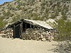 | November 8, 1974 (#74000282) | At base of Pena Mountain in Big Bend National Park 29°12′56″N 103°32′05″W / 29.2155°N 103.5348°W / 29.2155; -103.5348 (Luna Jacal) | Big Bend National Park | |
| 8 | Mariscal Mine |  | September 13, 1974 (#74000279) | River Rd. 29°05′42″N 103°11′17″W / 29.095°N 103.1881°W / 29.095; -103.1881 (Mariscal Mine) | Big Bend National Park | |
| 9 | Nolte-Rooney House | 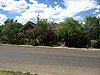 | April 17, 1997 (#97000360) | 307 E. Sul Ross Ave. 30°21′37″N 103°39′35″W / 30.3602°N 103.6597°W / 30.3602; -103.6597 (Nolte-Rooney House) | Alpine | Recorded Texas Historic Landmark |
| 10 | Panther Junction Mission 66 Historic District | 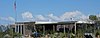 | September 19, 2014 (#14000626) | P.O. Box 129 29°19′40″N 103°12′21″W / 29.3278°N 103.2059°W / 29.3278; -103.2059 (Panther Junction Mission 66 Historic District) | Big Bend National Park | |
| 11 | Rancho Estelle |  | September 3, 1974 (#74000280) | On the Rio Grande 29°09′20″N 103°34′35″W / 29.1556°N 103.5764°W / 29.1556; -103.5764 (Rancho Estelle) | Big Bend National Park | |
| 12 | Terlingua Historic District |  | March 10, 1996 (#96000132) | 7 mi. W of jct. of TX 118 and TX 170 29°19′15″N 103°36′57″W / 29.3208°N 103.6158°W / 29.3208; -103.6158 (Terlingua Historic District) | Terlingua | |
| 13 | Homer Wilson Ranch | 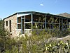 | April 14, 1975 (#75000153) | 8 mi. S of Santa Elena Junction on Park Rte. 5, Big Bend National Park 29°12′50″N 103°22′00″W / 29.2139°N 103.3667°W / 29.2139; -103.3667 (Homer Wilson Ranch) | Santa Elena Junction |
See also
 National Register of Historic Places portal
 Texas portal


- National Register of Historic Places listings in Texas
- Recorded Texas Historic Landmarks in Brewster County
References
- ^ National Park Service, United States Department of the Interior, "National Register of Historic Places: Weekly List Actions", retrieved September 13, 2024.
- ^ The latitude and longitude information provided in this table was derived originally from the National Register Information System, which has been found to be fairly accurate for about 99% of listings. Some locations in this table may have been corrected to current GPS standards.
- ^ Numbers represent an alphabetical ordering by significant words. Various colorings, defined here, differentiate National Historic Landmarks and historic districts from other NRHP buildings, structures, sites or objects.
- ^ "National Register Information System". National Register of Historic Places. National Park Service. April 24, 2008.
- ^ The eight-digit number below each date is the number assigned to each location in the National Register Information System database, which can be viewed by clicking the number.
- ^ Federal and state laws and practices restrict general public access to information regarding the specific location of this resource. In some cases, this is to protect archeological sites from vandalism, while in other cases it is restricted at the request of the owner. See: Knoerl, John; Miller, Diane; Shrimpton, Rebecca H. (1990), Guidelines for Restricting Information about Historic and Prehistoric Resources, National Register Bulletin, National Park Service, U.S. Department of the Interior, OCLC 20706997.
External links
![]() Media related to National Register of Historic Places in Brewster County, Texas at Wikimedia Commons
Media related to National Register of Historic Places in Brewster County, Texas at Wikimedia Commons
- v
- t
- e
by county
- Anderson
- Andrews
- Angelina
- Aransas
- Archer
- Armstrong
- Atascosa
- Austin
- Bailey
- Bandera
- Bastrop
- Baylor
- Bee
- Bell
- Bexar
- Blanco
- Borden
- Bosque
- Bowie
- Brazoria
- Brazos
- Brewster
- Briscoe
- Brooks
- Brown
- Burleson
- Burnet
- Caldwell
- Calhoun
- Callahan
- Cameron
- Camp
- Carson
- Cass
- Castro
- Chambers
- Cherokee
- Childress
- Clay
- Cochran
- Coke
- Coleman
- Collin
- Collingsworth
- Colorado
- Comal
- Comanche
- Concho
- Cooke
- Coryell
- Cottle
- Crane
- Crockett
- Crosby
- Culberson
- Dallam
- Dallas
- Dawson
- Deaf Smith
- Delta
- Denton
- DeWitt
- Dickens
- Dimmit
- Donley
- Duval
- Eastland
- Ector
- Edwards
- El Paso
- Ellis
- Erath
- Falls
- Fannin
- Fayette
- Fisher
- Floyd
- Foard
- Fort Bend
- Franklin
- Freestone
- Frio
- Gaines
- Galveston
- Garza
- Gillespie
- Glasscock
- Goliad
- Gonzales
- Gray
- Grayson
- Gregg
- Grimes
- Guadalupe
- Hale
- Hall
- Hamilton
- Hansford
- Hardeman
- Hardin
- Harris
- Harrison
- Hartley
- Haskell
- Hays
- Hemphill
- Henderson
- Hidalgo
- Hill
- Hockley
- Hood
- Hopkins
- Houston
- Howard
- Hudspeth
- Hunt
- Hutchinson
- Irion
- Jack
- Jackson
- Jasper
- Jeff Davis
- Jefferson
- Jim Hogg
- Jim Wells
- Johnson
- Jones
- Karnes
- Kaufman
- Kendall
- Kenedy
- Kent
- Kerr
- Kimble
- King
- Kinney
- Kleberg
- Knox
- La Salle
- Lamar
- Lamb
- Lampasas
- Lavaca
- Lee
- Leon
- Liberty
- Limestone
- Lipscomb
- Live Oak
- Llano
- Loving
- Lubbock
- Lynn
- Madison
- Marion
- Martin
- Mason
- Matagorda
- Maverick
- McCulloch
- McLennan
- McMullen
- Medina
- Menard
- Midland
- Milam
- Mills
- Mitchell
- Montague
- Montgomery
- Moore
- Morris
- Motley
- Nacogdoches
- Navarro
- Newton
- Nolan
- Nueces
- Ochiltree
- Oldham
- Orange
- Palo Pinto
- Panola
- Parker
- Parmer
- Pecos
- Polk
- Potter
- Presidio
- Rains
- Randall
- Reagan
- Real
- Red River
- Reeves
- Refugio
- Roberts
- Robertson
- Rockwall
- Runnels
- Rusk
- Sabine
- San Augustine
- San Jacinto
- San Patricio
- San Saba
- Schleicher
- Scurry
- Shackelford
- Shelby
- Sherman
- Smith
- Somervell
- Starr
- Stephens
- Sterling
- Stonewall
- Sutton
- Swisher
- Tarrant
- Taylor
- Terrell
- Terry
- Throckmorton
- Titus
- Tom Green
- Travis
- Trinity
- Tyler
- Upshur
- Upton
- Uvalde
- Val Verde
- Van Zandt
- Victoria
- Walker
- Waller
- Ward
- Washington
- Webb
- Wharton
- Wheeler
- Wichita
- Wilbarger
- Willacy
- Williamson
- Wilson
- Winkler
- Wise
- Wood
- Yoakum
- Young
- Zapata
- Zavala

Municipalities and communities of Brewster County, Texas, United States | ||
|---|---|---|
County seat: Alpine | ||
| City |  | |
| CDPs | ||
| Other communities | ||
| Ghost towns |
| |
| Annexed former counties | ||
| ||


