Wachusett Dam
Dam in Massachusetts
Dam in Massachusetts, USA
42°24′13″N 71°41′16″W / 42.40361°N 71.68778°W / 42.40361; -71.68778Wachusett Dam Historic District


The Wachusett Dam in Clinton, Massachusetts, impounds the Nashua River, creating the Wachusett Reservoir. Construction started in 1897[2] and was completed in 1905. It is part of the Nashua River Watershed.
This dam is part of greater Boston's water system, maintained and controlled by the Massachusetts Water Resources Authority (MWRA). Its discharge is into the Nashua River. When it was completed in 1905, the Wachusett Reservoir was the largest public water supply reservoir in the world.[2] At that time, the Wachusett Reservoir Dam was the largest gravity dam in the world as well.
Construction
The Metropolitan Water Board selected the south branch of the Nashua River in Clinton as the best site for Boston's new water supply over New Hampshire's Lake Winnipesaukee, Maine's Sebago Lake, and the Merrimack River.[2]
Churches, factories, homes, and schools within the valley had to be knocked down or moved. Roads and rail lines had to be relocated; a railroad tunnel and trestle had to be built in order to relocate the Central Massachusetts Railroad, and over four thousand bodies had to be dug up and moved in the local Catholic cemetery.[citation needed] The project brought thousands of immigrants to the area for work.
The dam created the world's largest water supply reservoir at the time.[2] It is still considered the largest "hand dug" dam in the world today.[citation needed]
Early problems
A static liquefaction flow failure occurred in the upstream slope of the North Dike of Wachusett Dam near Clinton, Massachusetts on April 11, 1907 during the first reservoir filling. The fine sands of the upstream dike shell liquefied and flowed approximately 100 meters horizontally into the reservoir.
Gallery
-
 Wachusett Dam outlet
 -
 The reservoir side of the dam
 -
 The plaque on the dam
 -
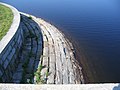 Rough-hewn rocks lining the reservoir
 -
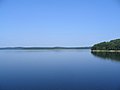 The reservoir itself
 -
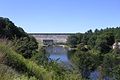 The dam from downstream


See also
References
- ^ "National Register Information System". National Register of Historic Places. National Park Service. January 23, 2007.
- ^ a b c d History: Wachusett
External links
Wikimedia Commons has media related to Wachusett Dam.
- Wachusett Dam at Structurae
- USGS
- v
- t
- e
Commonwealth of Massachusetts
Boston (capital)
- Index
- Administrative divisions
- Congressional districts
- Elections
- Geography
- Geology
- Government
- History
- Images
- Law
- Lighthouses
- Music
- People
- State symbols
- Transportation
- Villages
- Tourist attractions
- Windmills
- Cape Ann
- Central Massachusetts (Blackstone Valley, Montachusett-North County, South County)
- Greater Boston
- Greater Lowell
- Merrimack Valley
- MetroWest
- North Shore
- Southeastern Massachusetts (Cape Cod, South Coast, South Shore)
- Western Massachusetts (The Berkshires, Housatonic Valley, Pioneer Valley, Quabbin-Swift River Valley)
- Agawam
- Amherst
- Amesbury
- Attleboro
- Barnstable
- Beverly
- Boston
- Braintree
- Bridgewater
- Brockton
- Cambridge
- Chelsea
- Chicopee
- East Longmeadow
- Easthampton
- Everett
- Fall River
- Fitchburg
- Framingham
- Franklin
- Gardner
- Gloucester
- Greenfield
- Haverhill
- Holyoke
- Lawrence
- Leominster
- Lowell
- Lynn
- Malden
- Marlborough
- Medford
- Melrose
- Methuen
- New Bedford
- Newburyport
- Newton
- North Adams
- Northampton
- Palmer
- Peabody
- Pittsfield
- Quincy
- Randolph
- Revere
- Salem
- Somerville
- Southbridge
- Springfield
- Taunton
- Waltham
- Watertown
- Westfield
- West Springfield
- Weymouth
- Winthrop
- Woburn
- Worcester
- Note: Municipalities not listed have a town meeting form of government (see all municipalities)
 Massachusetts portal
| |||||||||||||||||
|---|---|---|---|---|---|---|---|---|---|---|---|---|---|---|---|---|---|
| Topics |  | ||||||||||||||||
| Lists by county | |||||||||||||||||
| Lists by city |
| ||||||||||||||||
| Other lists | |||||||||||||||||
| |||||||||||||||||


| Authority control databases: Geographic |
|
|---|


