National Register of Historic Places listings in Quincy, Massachusetts
The following properties located in Quincy, Massachusetts are listed on the National Register of Historic Places.
This National Park Service list is complete through NPS recent listings posted May 10, 2024.[1]
Current listings
Map all coordinates using OpenStreetMap
Download coordinates as:
- KML
- GPX (all coordinates)
- GPX (primary coordinates)
- GPX (secondary coordinates)
| [2] | Name on the Register | Image | Date listed[3] | Location | City or town | Description |
|---|---|---|---|---|---|---|
| 1 | Adams Academy |  | September 6, 1974 (#74000379) | 8 Adams St. 42°15′13″N 71°00′23″W / 42.253611°N 71.006389°W / 42.253611; -71.006389 (Adams Academy) | ||
| 2 | Adams Building |  | June 23, 1983 (#83000593) | 1342–1368 Hancock St.; 1–9 Temple St. 42°15′01″N 71°00′11″W / 42.250278°N 71.003056°W / 42.250278; -71.003056 (Adams Building) | ||
| 3 | Adams National Historic Site | 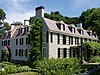 | October 15, 1966 (#66000051) | 135 Adams St. 42°15′47″N 71°00′42″W / 42.263056°N 71.011667°W / 42.263056; -71.011667 (Adams National Historic Site) | ||
| 4 | John Quincy Adams Birthplace |  | October 15, 1966 (#66000128) | 141 Franklin St. 42°14′21″N 71°00′15″W / 42.239167°N 71.004167°W / 42.239167; -71.004167 (John Quincy Adams Birthplace) | ||
| 5 | John Adams Birthplace |  | October 15, 1966 (#66000129) | 133 Franklin St. 42°14′22″N 71°00′15″W / 42.239444°N 71.004167°W / 42.239444; -71.004167 (John Adams Birthplace) | ||
| 6 | Arthur Alden House |  | September 20, 1989 (#89001382) | 24 Whitney Rd. 42°15′15″N 71°00′18″W / 42.254167°N 71.005°W / 42.254167; -71.005 (Arthur Alden House) | ||
| 7 | Randolph Bainbridge House |  | September 20, 1989 (#89001340) | 133 Grandview Ave. 42°15′40″N 71°01′05″W / 42.261111°N 71.018056°W / 42.261111; -71.018056 (Randolph Bainbridge House) | ||
| 8 | George A. Barker House |  | September 20, 1989 (#89001345) | 74 Greenleaf St. 42°15′24″N 71°00′16″W / 42.256667°N 71.004444°W / 42.256667; -71.004444 (George A. Barker House) | ||
| 9 | Henry F. Barker House |  | September 20, 1989 (#89001346) | 103 Greenleaf St. 42°15′23″N 71°00′15″W / 42.256389°N 71.004167°W / 42.256389; -71.004167 (Henry F. Barker House) | ||
| 10 | Barnes House |  | September 20, 1989 (#89001362) | 183 Pine St. 42°15′40″N 71°01′45″W / 42.261111°N 71.029167°W / 42.261111; -71.029167 (Barnes House) | ||
| 11 | S. H. Barnicoat Monuments |  | September 20, 1989 (#89001325) | 114 Columbia St. 42°14′06″N 71°00′44″W / 42.235°N 71.012222°W / 42.235; -71.012222 (S. H. Barnicoat Monuments) | Demolished for commercial development. | |
| 12 | William R. Bateman House |  | September 20, 1989 (#89001359) | 148 Monroe Rd. 42°15′06″N 71°00′32″W / 42.251667°N 71.008889°W / 42.251667; -71.008889 (William R. Bateman House) | ||
| 13 | Baxter Street Historic District |  | September 20, 1989 (#89001309) | Roughly 19-34 Baxter St. 42°14′58″N 70°59′57″W / 42.249444°N 70.999167°W / 42.249444; -70.999167 (Baxter Street Historic District) | ||
| 14 | Baxter-King House |  | November 13, 1989 (#89001953) | 270 Adams St. 42°15′12″N 71°01′00″W / 42.253333°N 71.016667°W / 42.253333; -71.016667 (Baxter-King House) | ||
| 15 | Bethany Congregational Church |  | September 20, 1989 (#89001374) | 8 Spear St. 42°15′06″N 71°00′04″W / 42.251667°N 71.001111°W / 42.251667; -71.001111 (Bethany Congregational Church) | ||
| 16 | Blue Hills Reservation Parkways-Metropolitan Park System of Greater Boston |  | August 11, 2003 (#03000746) | Parts of Blue Hill Rd., Chickatawbut Rd., Hillside St., Uniquity Rd., Wampatuck Rd., and Green St. 42°13′34″N 71°04′20″W / 42.226111°N 71.072222°W / 42.226111; -71.072222 (Blue Hills Reservation Parkways-Metropolitan Park System of Greater Boston) | Extends into Milton and into Braintree and Canton, elsewhere in Norfolk County | |
| 17 | Boston Harbor Islands Archeological District |  | December 21, 1985 (#85003323) | Address Restricted | Extends into Hingham in Plymouth County and Boston in Suffolk County | |
| 18 | Brown-Hodgkinson House |  | September 20, 1989 (#89001319) | 42 Bicknell St. 42°15′07″N 70°57′54″W / 42.251944°N 70.965°W / 42.251944; -70.965 (Brown-Hodgkinson House) | ||
| 19 | Building at 1–7 Moscow Street |  | September 20, 1989 (#89001360) | 1–7 Moscow St. 42°16′29″N 71°01′40″W / 42.274722°N 71.027778°W / 42.274722; -71.027778 (Building at 1–7 Moscow Street) | ||
| 20 | Building at 51 Hunt Street |  | September 20, 1989 (#89001355) | 51 Hunt St. 42°16′39″N 71°01′42″W / 42.2775°N 71.028333°W / 42.2775; -71.028333 (Building at 51 Hunt Street) | ||
| 21 | Charles H. Burgess House |  | September 20, 1989 (#89001381) | 17 Whitney Rd. 42°15′13″N 71°00′18″W / 42.253611°N 71.005°W / 42.253611; -71.005 (Charles H. Burgess House) | ||
| 22 | Frank Burgess House |  | September 20, 1989 (#89001354) | 355 Highland Ave. 42°15′36″N 71°01′23″W / 42.26°N 71.023056°W / 42.26; -71.023056 (Frank Burgess House) | ||
| 23 | Clarence Burgin House |  | September 20, 1989 (#89001364) | 95 President's Ln. 42°15′11″N 71°00′31″W / 42.253056°N 71.008611°W / 42.253056; -71.008611 (Clarence Burgin House) | ||
| 24 | Central Fire Station |  | September 20, 1989 (#89001371) | 26 Quincy Ave. 42°14′40″N 70°59′57″W / 42.244444°N 70.999167°W / 42.244444; -70.999167 (Central Fire Station) | ||
| 25 | Chickatawbut Observation Tower |  | September 25, 1980 (#80000652) | Chickatawbut Rd. 42°13′30″N 71°03′41″W / 42.225°N 71.061389°W / 42.225; -71.061389 (Chickatawbut Observation Tower) | ||
| 26 | Christ Church |  | September 20, 1989 (#89001369) | 14 Quincy St. 42°14′43″N 70°59′59″W / 42.245278°N 70.999722°W / 42.245278; -70.999722 (Christ Church) | ||
| 27 | Christ Church Burial Ground | 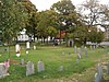 | September 20, 1989 (#89001372) | 54–60 School St. 42°14′39″N 71°00′09″W / 42.244167°N 71.0025°W / 42.244167; -71.0025 (Christ Church Burial Ground) | ||
| 28 | Coddington School |  | September 20, 1989 (#89001323) | 26–44 Coddington St. 42°15′08″N 71°00′09″W / 42.252222°N 71.0025°W / 42.252222; -71.0025 (Coddington School) | ||
| 29 | Cranch School |  | July 5, 1984 (#84002872) | 270 Whitwell St. 42°14′57″N 71°00′36″W / 42.249167°N 71.01°W / 42.249167; -71.01 (Cranch School) | ||
| 30 | Frank W. Crane House |  | September 20, 1989 (#89001312) | 11 Avon Way 42°15′03″N 71°00′29″W / 42.250833°N 71.008056°W / 42.250833; -71.008056 (Frank W. Crane House) | ||
| 31 | Thomas Crane Public Library |  | October 18, 1972 (#72000143) | 40 Washington St. 42°15′06″N 71°00′05″W / 42.251667°N 71.001389°W / 42.251667; -71.001389 (Thomas Crane Public Library) | ||
| 32 | Noah Curtis House |  | September 20, 1989 (#89001335) | 313 Franklin St. 42°14′02″N 71°00′01″W / 42.233889°N 71.000278°W / 42.233889; -71.000278 (Noah Curtis House) | ||
| 33 | Thomas Curtis House |  | September 20, 1989 (#89001334) | 279 Franklin St. 42°14′06″N 71°00′01″W / 42.235°N 71.000333°W / 42.235; -71.000333 (Thomas Curtis House) | ||
| 34 | Dr. Frank Davis House |  | September 20, 1989 (#89001330) | 25 Elm St. 42°14′48″N 70°59′57″W / 42.246667°N 70.999167°W / 42.246667; -70.999167 (Dr. Frank Davis House) | ||
| 35 | Russell M. Dicey House |  | September 20, 1989 (#89001363) | 56 Pope St. 42°16′12″N 71°02′14″W / 42.27°N 71.037222°W / 42.27; -71.037222 (Russell M. Dicey House) | ||
| 36 | Solon Dogget House |  | September 20, 1989 (#89001379) | 50 Union St. 42°14′56″N 70°59′52″W / 42.248889°N 70.997778°W / 42.248889; -70.997778 (Solon Dogget House) | ||
| 37 | Dorothy Q Apartments |  | September 20, 1989 (#89001322) | 36 Butler Rd. 42°15′29″N 71°00′26″W / 42.258056°N 71.007222°W / 42.258056; -71.007222 (Dorothy Q Apartments) | ||
| 38 | Elks Building |  | September 20, 1989 (#89001348) | 1218–1222 Hancock St. 42°15′09″N 71°00′17″W / 42.2525°N 71.004722°W / 42.2525; -71.004722 (Elks Building) | ||
| 39 | Faxon House |  | September 20, 1989 (#89001310) | 310 Adams St. 42°15′11″N 71°01′02″W / 42.253056°N 71.017222°W / 42.253056; -71.017222 (Faxon House) | ||
| 40 | First Baptist Church of Wollaston |  | September 20, 1989 (#89001380) | 187 Warren Ave. 42°15′37″N 71°01′15″W / 42.260278°N 71.020833°W / 42.260278; -71.020833 (First Baptist Church of Wollaston) | ||
| 41 | Forbes Hill Standpipe |  | January 18, 1990 (#89002252) | Reservoir Rd. 42°15′27″N 71°01′42″W / 42.2575°N 71.028333°W / 42.2575; -71.028333 (Forbes Hill Standpipe) | ||
| 42 | Fore River Club House |  | September 20, 1989 (#89001333) | Follett and Beechwood Sts. 42°15′01″N 70°58′44″W / 42.250278°N 70.978889°W / 42.250278; -70.978889 (Fore River Club House) | ||
| 43 | Furnace Brook Parkway |  | March 18, 2004 (#04000248) | Furnace Brook Parkway 42°14′59″N 71°01′18″W / 42.249722°N 71.021667°W / 42.249722; -71.021667 (Furnace Brook Parkway) | ||
| 44 | Glover House |  | September 20, 1989 (#89001328) | 249 E. Squantum St. 42°17′00″N 71°01′29″W / 42.283333°N 71.024722°W / 42.283333; -71.024722 (Glover House) | ||
| 45 | Granite Trust Company |  | September 20, 1989 (#89001351) | 1400 Hancock St. 42°14′58″N 71°00′10″W / 42.249444°N 71.002778°W / 42.249444; -71.002778 (Granite Trust Company) | ||
| 46 | John Halloran House |  | September 20, 1989 (#89001327) | 99 E. Squantum St. 42°16′44″N 71°01′36″W / 42.278889°N 71.026667°W / 42.278889; -71.026667 (John Halloran House) | ||
| 47 | Hancock Cemetery |  | January 28, 1982 (#82004421) | Hancock St. in Quincy Sq. 42°15′02″N 70°59′46″W / 42.250556°N 70.996111°W / 42.250556; -70.996111 (Hancock Cemetery) | ||
| 48 | Hardwick House |  | September 20, 1989 (#89001376) | 59–61 Spear St. 42°15′06″N 71°00′04″W / 42.251667°N 71.001111°W / 42.251667; -71.001111 (Hardwick House) | ||
| 49 | House at 105 President's Lane |  | September 20, 1989 (#89001365) | 105 President's Ln. 42°15′11″N 71°00′30″W / 42.253056°N 71.008333°W / 42.253056; -71.008333 (House at 105 President's Lane) | ||
| 50 | House at 15 Gilmore Street |  | September 20, 1989 (#89001336) | 15 Gilmore St. 42°15′32″N 71°00′38″W / 42.258889°N 71.010556°W / 42.258889; -71.010556 (House at 15 Gilmore Street) | ||
| 51 | House at 20 Sterling Street |  | September 20, 1989 (#89001377) | 20 Sterling St. 42°16′18″N 71°02′12″W / 42.271667°N 71.036667°W / 42.271667; -71.036667 (House at 20 Sterling Street) | ||
| 52 | House at 23–25 Prout Street |  | September 20, 1989 (#89001367) | 23–25 Prout St. 42°14′37″N 71°00′56″W / 42.243611°N 71.015556°W / 42.243611; -71.015556 (House at 23–25 Prout Street) | ||
| 53 | House at 25 High School Avenue |  | September 20, 1989 (#89001352) | 25 High School Ave. 42°14′43″N 70°59′58″W / 42.245278°N 70.999444°W / 42.245278; -70.999444 (House at 25 High School Avenue) | ||
| 54 | House at 32 Bayview Avenue |  | September 20, 1989 (#89001314) | 32 Bayview Ave. 42°16′17″N 70°57′02″W / 42.271389°N 70.950556°W / 42.271389; -70.950556 (House at 32 Bayview Avenue) | ||
| 55 | House at 92 Willard Street |  | September 20, 1989 (#89001383) | 92 Willard St. 42°15′07″N 71°02′13″W / 42.251944°N 71.036944°W / 42.251944; -71.036944 (House at 92 Willard Street) | ||
| 56 | House at 94 Grandview Avenue |  | September 20, 1989 (#89001339) | 94 Grandview Ave. 42°15′46″N 71°01′08″W / 42.262778°N 71.018889°W / 42.262778; -71.018889 (House at 94 Grandview Avenue) | ||
| 57 | David L. Jewell House |  | September 20, 1989 (#89001338) | 48 Grandview Ave. 42°15′50″N 71°01′11″W / 42.263889°N 71.019722°W / 42.263889; -71.019722 (David L. Jewell House) | ||
| 58 | Edward J. Lennon House |  | September 20, 1989 (#89001378) | 53 Taber St. 42°14′12″N 71°00′41″W / 42.236667°N 71.011389°W / 42.236667; -71.011389 (Edward J. Lennon House) | ||
| 59 | Lyon's Turning Mill |  | September 25, 1980 (#80000656) | Ricciuti Dr.[4] 42°14′37″N 71°02′52″W / 42.2437°N 71.0478°W / 42.2437; -71.0478 (Lyon's Turning Mill) | ||
| 60 | Charles Marsh House |  | September 20, 1989 (#89001366) | 248 President's Ln. 42°14′55″N 71°00′18″W / 42.248611°N 71.005°W / 42.248611; -71.005 (Charles Marsh House) | Torn down for new development. | |
| 61 | Edwin W. Marsh House |  | September 20, 1989 (#89001356) | 17 Marsh St. 42°14′35″N 71°00′22″W / 42.243056°N 71.006111°W / 42.243056; -71.006111 (Edwin W. Marsh House) | ||
| 62 | Masonic Temple |  | November 13, 1989 (#89001952) | 1156 Hancock St. 42°15′12″N 71°00′18″W / 42.253333°N 71.005°W / 42.253333; -71.005 (Masonic Temple) | ||
| 63 | Massachusetts Fields School |  | November 13, 1990 (#88000960) | Rawson Rd. and Beach St. 42°16′19″N 71°01′00″W / 42.271944°N 71.016667°W / 42.271944; -71.016667 (Massachusetts Fields School) | ||
| 64 | Massachusetts Hornfels-Braintree Slate Quarry |  | September 25, 1980 (#80000653) | Address Restricted | Extends into Milton. | |
| 65 | Herman McIntire House |  | September 20, 1989 (#89001326) | 55 Dixwell Ave. 42°15′01″N 71°00′33″W / 42.250278°N 71.009167°W / 42.250278; -71.009167 (Herman McIntire House) | ||
| 66 | Edward Miller House |  | March 8, 1990 (#89001358) | 36 Miller Stile Rd. 42°14′59″N 70°59′59″W / 42.249722°N 70.999722°W / 42.249722; -70.999722 (Edward Miller House) | ||
| 67 | Moswetuset Hummock |  | July 1, 1970 (#70000094) | Squantum St. near its junction with Morrissey Rd. 42°17′22″N 71°01′18″W / 42.289444°N 71.021667°W / 42.289444; -71.021667 (Moswetuset Hummock) | ||
| 68 | Mount Wollaston Cemetery |  | February 18, 1994 (#94000035) | 20 Sea St. 42°15′31″N 70°59′56″W / 42.258611°N 70.998889°W / 42.258611; -70.998889 (Mount Wollaston Cemetery) | ||
| 69 | Munroe Building |  | September 20, 1989 (#89001349) | 1227–1259 Hancock St. 42°15′08″N 71°00′18″W / 42.252222°N 71.005°W / 42.252222; -71.005 (Munroe Building) | ||
| 70 | John R. Nelson House |  | September 20, 1989 (#89001321) | 4 Brunswick St. 42°17′52″N 71°00′32″W / 42.297778°N 71.008889°W / 42.297778; -71.008889 (John R. Nelson House) | ||
| 71 | New England Telephone Building |  | September 20, 1989 (#89001357) | 10 Merrymount Rd. 42°15′23″N 71°00′26″W / 42.256389°N 71.007222°W / 42.256389; -71.007222 (New England Telephone Building) | ||
| 72 | Newcomb Place |  | September 20, 1989 (#89001368) | 109 Putnam St. 42°15′25″N 71°00′19″W / 42.256944°N 71.005278°W / 42.256944; -71.005278 (Newcomb Place) | ||
| 73 | Nightengale House |  | September 20, 1989 (#89001370) | 24 Quincy St. 42°14′32″N 71°00′23″W / 42.242222°N 71.006389°W / 42.242222; -71.006389 (Nightengale House) | ||
| 74 | Solomon Nightengale House |  | September 20, 1989 (#89001342) | 429 Granite St. 42°14′43″N 71°00′19″W / 42.245278°N 71.005278°W / 42.245278; -71.005278 (Solomon Nightengale House) | House torn down (more likely) or rebuilt beyond recognition. | |
| 75 | J. Martin Nowland House |  | September 20, 1989 (#89001329) | 31 Edgemere Rd. 42°15′22″N 71°00′13″W / 42.256111°N 71.003611°W / 42.256111; -71.003611 (J. Martin Nowland House) | ||
| 76 | C. F. Pettengill House |  | November 13, 1989 (#89001951) | 53 Revere Rd. 42°14′52″N 71°00′02″W / 42.247778°N 71.000556°W / 42.247778; -71.000556 (C. F. Pettengill House) | ||
| 77 | Pinkham House |  | September 20, 1989 (#89001384) | 79 Winthrop Ave. 42°15′40″N 71°01′11″W / 42.261111°N 71.019722°W / 42.261111; -71.019722 (Pinkham House) | ||
| 78 | Pratt-Faxon House |  | September 20, 1989 (#89001331) | 75 Faxon Ln. 42°14′30″N 70°59′51″W / 42.241667°N 70.9975°W / 42.241667; -70.9975 (Pratt-Faxon House) | ||
| 79 | Quincy Electric Light and Power Company Station |  | September 20, 1989 (#89001332) | 76 Field St. 42°15′16″N 70°59′31″W / 42.254444°N 70.991944°W / 42.254444; -70.991944 (Quincy Electric Light and Power Company Station) | ||
| 80 | Quincy Granite Railway |  | October 15, 1973 (#73000309) | Bunker Hill Lane 42°14′23″N 71°01′57″W / 42.239722°N 71.0325°W / 42.239722; -71.0325 (Quincy Granite Railway) | Encompasses a surviving section of railroad bed | |
| 81 | Quincy Granite Railway Incline |  | June 19, 1973 (#73000310) | Mullin Ave. 42°14′43″N 71°02′14″W / 42.245278°N 71.037222°W / 42.245278; -71.037222 (Quincy Granite Railway Incline) | ||
| 82 | Quincy Homestead |  | July 1, 1970 (#70000095) | 34 Butler Road 42°15′28″N 71°00′28″W / 42.257778°N 71.007778°W / 42.257778; -71.007778 (Quincy Homestead) | ||
| 83 | Quincy Point Fire Station |  | February 18, 1994 (#93000347) | 615 Washington St. 42°14′46″N 70°58′37″W / 42.246111°N 70.976944°W / 42.246111; -70.976944 (Quincy Point Fire Station) | ||
| 84 | Quincy Police Station |  | March 8, 1990 (#89001373) | 442 Southern Artery 42°15′21″N 70°59′47″W / 42.255833°N 70.996389°W / 42.255833; -70.996389 (Quincy Police Station) | ||
| 85 | Quincy Savings Bank |  | September 20, 1989 (#89001350) | 1370 Hancock St. 42°15′00″N 71°00′09″W / 42.25°N 71.0025°W / 42.25; -71.0025 (Quincy Savings Bank) | ||
| 86 | Quincy School |  | June 23, 1983 (#83000599) | 94 Newbury Ave. 42°16′50″N 71°01′44″W / 42.280556°N 71.028889°W / 42.280556; -71.028889 (Quincy School) | ||
| 87 | Quincy Shore Drive |  | June 23, 2003 (#03000575) | Quincy Shore Drive 42°16′35″N 71°01′04″W / 42.276389°N 71.017778°W / 42.276389; -71.017778 (Quincy Shore Drive) | ||
| 88 | Quincy Town Hall |  | January 11, 1980 (#80000649) | 1305 Hancock St. 42°15′03″N 71°00′15″W / 42.250833°N 71.004167°W / 42.250833; -71.004167 (Quincy Town Hall) | ||
| 89 | Quincy Water Company Pumping Station |  | September 20, 1989 (#89001361) | 106 Penn St. 42°14′09″N 71°00′27″W / 42.235833°N 71.0075°W / 42.235833; -71.0075 (Quincy Water Company Pumping Station) | Demolished, now a largely vacant lot. | |
| 90 | Josiah Quincy House |  | May 28, 1976 (#76000285) | 20 Muirhead St. 42°16′18″N 71°00′56″W / 42.271667°N 71.015556°W / 42.271667; -71.015556 (Josiah Quincy House) | ||
| 91 | Jonathan Dexter Record House |  | September 20, 1989 (#89001337) | 39–41 Grandview Ave. 42°15′50″N 71°01′13″W / 42.263889°N 71.020278°W / 42.263889; -71.020278 (Jonathan Dexter Record House) | ||
| 92 | Timothy Reed House |  | September 20, 1989 (#89001311) | 284 Adams St. 42°15′13″N 71°01′01″W / 42.253611°N 71.016944°W / 42.253611; -71.016944 (Timothy Reed House) | ||
| 93 | Alfred H. Richards House |  | September 20, 1989 (#89001353) | 354 Highland Ave. 42°15′37″N 71°01′17″W / 42.260278°N 71.021389°W / 42.260278; -71.021389 (Alfred H. Richards House) | ||
| 94 | Salem Lutheran Church |  | September 20, 1989 (#89001341) | 199 Granite St. 42°14′41″N 71°00′31″W / 42.244725°N 71.008544°W / 42.244725; -71.008544 (Salem Lutheran Church) | Now named "Faith Lutheran Church" | |
| 95 | George A. Sidelinger House |  | September 20, 1989 (#89001313) | 19 Avon Way 42°15′02″N 71°00′30″W / 42.250556°N 71.008333°W / 42.250556; -71.008333 (George A. Sidelinger House) | ||
| 96 | A. C. Smith & Co. Gas Station |  | February 23, 1994 (#94000036) | 117 Beale St. 42°15′54″N 71°01′16″W / 42.265°N 71.021111°W / 42.265; -71.021111 (A. C. Smith & Co. Gas Station) | ||
| 97 | South Junior High School |  | September 20, 1989 (#89001343) | 444 Granite St. 42°14′24″N 71°00′59″W / 42.24°N 71.016389°W / 42.24; -71.016389 (South Junior High School) | ||
| 98 | Seth Spear Homestead |  | September 20, 1989 (#89001375) | 47–49 Spear St. 42°15′06″N 71°00′05″W / 42.251667°N 71.001389°W / 42.251667; -71.001389 (Seth Spear Homestead) | ||
| 99 | United First Parish Church (Unitarian) of Quincy |  | December 30, 1970 (#70000734) | 1266 Hancock St. 42°15′04″N 71°00′13″W / 42.251111°N 71.003611°W / 42.251111; -71.003611 (United First Parish Church (Unitarian) of Quincy) | ||
| 100 | US Post Office-Quincy Main |  | May 23, 1986 (#86001217) | 47 Washington St. 42°15′03″N 71°00′08″W / 42.250833°N 71.002222°W / 42.250833; -71.002222 (US Post Office-Quincy Main) | ||
| 101 | Charles E. White House |  | September 20, 1989 (#89001320) | 101 Billings Rd. 42°16′28″N 71°01′24″W / 42.274444°N 71.023333°W / 42.274444; -71.023333 (Charles E. White House) | ||
| 102 | Winfield House |  | September 20, 1989 (#89001347) | 853 Hancock St. 42°15′43″N 71°00′47″W / 42.261944°N 71.013056°W / 42.261944; -71.013056 (Winfield House) | Stairway leading up to vacant house lot. Burned some time ago. | |
| 103 | John Winthrop, Jr. Iron Furnace Site |  | September 20, 1977 (#77000192) | 61 Crescent St. 42°14′45″N 71°01′37″W / 42.245778°N 71.027083°W / 42.245778; -71.027083 (John Winthrop, Jr. Iron Furnace Site) | Although NRIS shows this as "Address Restricted", it is a public site, on the Quincy Historical Trail | |
| 104 | Wollaston Branch, Thomas Crane Public Library |  | September 20, 1989 (#89001316) | 41 Beale St. 42°16′00″N 71°01′06″W / 42.266667°N 71.018333°W / 42.266667; -71.018333 (Wollaston Branch, Thomas Crane Public Library) | ||
| 105 | Wollaston Congregational Church |  | December 5, 2008 (#08001128) | 47–57 Lincoln Ave. 42°15′46″N 71°01′12″W / 42.262694°N 71.02°W / 42.262694; -71.02 (Wollaston Congregational Church) | ||
| 106 | Wollaston Fire Station |  | September 20, 1989 (#89001317) | 111 Beale St. 42°15′34″N 71°00′45″W / 42.259444°N 71.0125°W / 42.259444; -71.0125 (Wollaston Fire Station) | ||
| 107 | Wollaston Theatre |  | September 20, 1989 (#89001315) | 14 Beale St. 42°16′03″N 71°01′00″W / 42.2675°N 71.016667°W / 42.2675; -71.016667 (Wollaston Theatre) | Demolished in 2016 | |
| 108 | Wollaston Unitarian Church |  | September 20, 1989 (#89001318) | 155 Beale St. 42°15′51″N 71°01′20″W / 42.264167°N 71.022222°W / 42.264167; -71.022222 (Wollaston Unitarian Church) | ||
| 109 | Woodward Institute |  | November 13, 1989 (#89001954) | 1098 Hancock St. 42°15′17″N 71°00′23″W / 42.254722°N 71.006389°W / 42.254722; -71.006389 (Woodward Institute) |
References
Wikimedia Commons has media related to National Register of Historic Places in Quincy, Massachusetts.
- ^ National Park Service, United States Department of the Interior, "National Register of Historic Places: Weekly List Actions", retrieved May 10, 2024.
- ^ Numbers represent an alphabetical ordering by significant words. Various colorings, defined here, differentiate National Historic Landmarks and historic districts from other NRHP buildings, structures, sites or objects.
- ^ The eight-digit number below each date is the number assigned to each location in the National Register Information System database, which can be viewed by clicking the number.
- ^ Location derived from this Quincy Quarry and Granite Workers Museum webpage; the NRIS lists the site as "Address Restricted"
- v
- t
- e

| Barnstable County | |
|---|---|
| Bristol County | |
| Essex County | |
| Hampden County | |
| Middlesex County | |
| Norfolk County | |
| Suffolk County | |
| Worcester County |
 Category
 National Register of Historic Places portal
 United States portal


