National Register of Historic Places listings in Marlborough, Massachusetts
List of Registered Historic Places in Marlborough, Massachusetts
This National Park Service list is complete through NPS recent listings posted May 31, 2024.[1]
Map all coordinates using OpenStreetMap
Download coordinates as:
- KML
- GPX (all coordinates)
- GPX (primary coordinates)
- GPX (secondary coordinates)
Marlborough
| [2] | Name on the Register[3] | Image | Date listed[4] | Location | City or town | Description |
|---|---|---|---|---|---|---|
| 1 | Brigham Cemetery |  | September 10, 2004 (#04000933) | off W. Main St. near Crescent St. 42°20′30″N 71°33′36″W / 42.3417°N 71.56°W / 42.3417; -71.56 (Brigham Cemetery) | ||
| 2 | John Cotting House |  | August 16, 1984 (#84002556) | 74 Main St. 42°20′49″N 71°32′46″W / 42.3469°N 71.5461°W / 42.3469; -71.5461 (John Cotting House) | ||
| 3 | Dennison Manufacturing Co. Paper Box Factory |  | November 19, 2008 (#08001070) | 175 Maple St. 42°20′29″N 71°32′36″W / 42.3414°N 71.5433°W / 42.3414; -71.5433 (Dennison Manufacturing Co. Paper Box Factory) | ||
| 4 | Maplewood Cemetery | 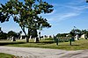 | September 29, 2004 (#04001082) | Pleasant St. 42°21′13″N 71°33′49″W / 42.3536°N 71.5636°W / 42.3536; -71.5636 (Maplewood Cemetery) | ||
| 5 | Marlborough Brook Filter Beds | 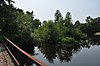 | January 18, 1990 (#89002286) | Framingham Rd. 42°19′47″N 71°32′09″W / 42.3297°N 71.5358°W / 42.3297; -71.5358 (Marlborough Brook Filter Beds) | Extends into Southborough, Worcester County. | |
| 6 | Marlborough Center Historic District |  | August 19, 1998 (#98000992) | Roughly bounded by MA 85, Granger Blvd., Mechanic St., Central St., and Washington St. 42°20′52″N 71°32′59″W / 42.3478°N 71.5497°W / 42.3478; -71.5497 (Marlborough Center Historic District) | ||
| 7 | Pleasant Street Historic District |  | September 27, 2001 (#01001061) | 187-235 Pleasant St. 42°20′59″N 71°33′49″W / 42.3497°N 71.5636°W / 42.3497; -71.5636 (Pleasant Street Historic District) | ||
| 8 | Capt. Peter Rice House | 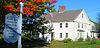 | April 9, 1980 (#80000641) | 377 Elm St. 42°20′51″N 71°34′30″W / 42.3475°N 71.575°W / 42.3475; -71.575 (Capt. Peter Rice House) | ||
| 9 | Robin Hill Cemetery |  | September 29, 2004 (#04001083) | Donald Lynch Blvd. 42°21′52″N 71°35′42″W / 42.3644°N 71.595°W / 42.3644; -71.595 (Robin Hill Cemetery) | ||
| 10 | Rocklawn Cemetery |  | October 6, 2004 (#04001115) | Stevens St. 42°21′10″N 71°32′27″W / 42.3528°N 71.5408°W / 42.3528; -71.5408 (Rocklawn Cemetery) | ||
| 11 | Spring Hill Cemetery |  | October 6, 2004 (#04001114) | High and Brown Sts. 42°20′53″N 71°32′34″W / 42.3480°N 71.5429°W / 42.3480; -71.5429 (Spring Hill Cemetery) | ||
| 12 | Temple Building |  | March 10, 1983 (#83000830) | 149 Main St. 42°20′49″N 71°32′56″W / 42.3469°N 71.5489°W / 42.3469; -71.5489 (Temple Building) | ||
| 13 | Wachusett Aqueduct Linear District |  | January 18, 1990 (#89002276) | Along Wachusett Aqueduct from Wachusett Reservoir to Sudbury Reservoir 42°20′01″N 71°35′27″W / 42.3336°N 71.5908°W / 42.3336; -71.5908 (Wachusett Aqueduct Linear District) | ||
| 14 | Warren Block | 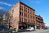 | March 10, 1983 (#83000836) | 155 Main St. 42°20′49″N 71°32′56″W / 42.3469°N 71.5489°W / 42.3469; -71.5489 (Warren Block) | ||
| 15 | Weeks Cemetery | 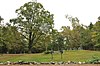 | September 10, 2004 (#04000934) | Corner of Sudbury St. and Concord Rd. 42°22′23″N 71°29′53″W / 42.3731°N 71.4981°W / 42.3731; -71.4981 (Weeks Cemetery) | ||
| 16 | West Main Street Historic District | 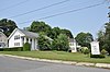 | November 8, 2001 (#01001215) | West Main, Pleasant, Winthrop and Witherbee Sts. 42°20′39″N 71°33′27″W / 42.3442°N 71.5575°W / 42.3442; -71.5575 (West Main Street Historic District) | ||
| 17 | Wilson Cemetery |  | September 10, 2004 (#04000958) | Wilson St. 42°21′09″N 71°30′29″W / 42.3525°N 71.5081°W / 42.3525; -71.5081 (Wilson Cemetery) |
References
Wikimedia Commons has media related to National Register of Historic Places in Marlborough, Massachusetts.
- ^ National Park Service, United States Department of the Interior, "National Register of Historic Places: Weekly List Actions", retrieved May 31, 2024.
- ^ Numbers represent an alphabetical ordering by significant words. Various colorings, defined here, differentiate National Historic Landmarks and historic districts from other NRHP buildings, structures, sites or objects.
- ^ "National Register Information System". National Register of Historic Places. National Park Service. April 24, 2008.
- ^ The eight-digit number below each date is the number assigned to each location in the National Register Information System database, which can be viewed by clicking the number.
- v
- t
- e

| Barnstable County | |
|---|---|
| Bristol County | |
| Essex County | |
| Hampden County | |
| Middlesex County | |
| Norfolk County | |
| Suffolk County | |
| Worcester County |
 Category
 National Register of Historic Places portal
 United States portal


