District de Nyamasheke

Cet article est une ébauche concernant le Rwanda.
Vous pouvez partager vos connaissances en l’améliorant (comment ?) selon les recommandations des projets correspondants.
Nyamasheke

| Pays |  Rwanda Rwanda |
|---|---|
| Province | Ouest |
| Chef-lieu | Nyamasheke |
| Superficie | 1 174 km2 |
| Coordonnées | 2° 22′ S, 29° 09′ E |
| Population | 434 221 hab. () |
|---|---|
| Densité | 369,9 hab./km2 () |
| Statut | District du Rwanda |
|---|

modifier - modifier le code - modifier Wikidata
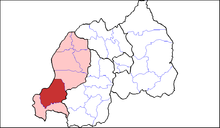
Nyamasheke est un district du Rwanda ainsi que l'une des grandes paroisses du diocèse de Cyangugu. Il se trouve au bord du lac Kivu au Rwanda.
Il se compose de quinze secteurs (imirenge) : Ruharambuga, Bushekeri, Bushenge, Cyato, Gihombo, Kagano, Kanjongo, Karambi, Karengera, Kirimbi, Macuba, Nyabitekeri, Mahembe, Rangiro, Shangi.
Le chef-lieu est Nyamasheke (ville) (Kagano).
Liens externes
v · m Districts du Rwanda | |
|---|---|
| Province de l'Est |
|
| Province du Nord | |
| Province de l'Ouest | |
| Province du Sud | |
| Kigali Ville | |
 Portail du Rwanda


