Serjbel
Village in Mount Lebanon, Lebanon
Serjbel سيرجبيل Sirjbel | |
|---|---|
Village | |
| 33°41′03″N 35°30′47″E / 33.68417°N 35.51306°E / 33.68417; 35.51306 | |
| Country |  Lebanon Lebanon |
| Governorate | Mount Lebanon |
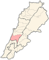
| District | Chouf |
| Elevation | 1,180 ft (360 m) |
| Time zone | UTC+2 (EET) |
| • Summer (DST) | +3 |
Serjbel (Arabic: سرجبال) is a small Lebanese village in the Chouf District of the Mont Liban state in Lebanon.[1]
References
- ^ Localiban (2015). "Sirjbal". Localiban. Data center on local development in Lebanon. Retrieved 8 July 2015.
External links
- Short video of life in Serjbel
- v
- t
- e
 Chouf District, Mount Lebanon Governorate
Capital: Beitedine
- Ain Qani
- Ain W Zain
- Ain Zhalta
- Ainbal
- Ammatour
- Baadarâne
- Baakleen
- Bakaata
- Barja
- Barouk
- Batloun
- Beitedine
- Beykoun
- El Bireh
- Bourjein et Marjiyat
- Boutmeh
- Brih
- Bsaba
- Dahr El Maghara
- Damour
- Daraya
- Deir el Qamar
- Dibbiyeh
- El Foûâra
- Haret Jandal
- Gharife
- Jahlieh
- Jdaideh
- Jieh
- Joun
- Kahlouniye
- Kfarfakoud
- Kfar Nabrakh
- Mazraat el-Chouf
- Mazraat el Daher
- Maasser
- Moukhtara
- Mtolleh
- Na'ameh
- Niha
- Rmeileh
- Serjbel
- Shheem
- Symkanieh
- Zaarourieh
 | This Lebanon location article is a stub. You can help Wikipedia by expanding it. |
- v
- t
- e


