Oval Maidan
Recreational activity ground in Mumbai

Oval Maidan is a large Grade I recreational ground situated in South Mumbai, India.[1] It is so named because of its oval shape and is situated just south of Churchgate. It is a popular recreation ground, with the most popular sports played there being cricket and football. The ground measures 22 acres (8.9 ha) in area.[1] Political rallies and religious functions are banned in the maidan.[2]

History
Until the early 20th century the vast expanses of the Oval Maidan, Azad Maidan, Cooperage Ground and Cross Maidan formed the area known as Esplanade.[3]
Until the late 20th century the ground was owned and run by the state government and was very poorly maintained. It was frequented by beggars, prostitutes and drug peddlers. Finally, in 1997 the Oval-Cooperage Residents Association (OCRA) was formed as a public charitable trust set up by the residents of the area. OCRA petitioned the Maharashtra government to maintain the Oval maidan. The Maharashtra government did not respond to the petition, leading the group to take it to the Mumbai High Court. The Court ruled in their favour, forcing the government to either maintain the maidan or hand it over to OCRA which it subsequently did.[citation needed]
The OCRA then went about fencing the ground and building a jogging course around the periphery. A lane which cut through the diameter of the ground was metalled to facilitate a smoother thoroughfare.[citation needed]
For a few years the former Indian cricketer Dilip Vengsarkar operated the Elf cricket academy to the north of the ground.
Gallery
-
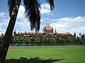 Oval Maidan with Mumbai High Court in the background
 -
 Oval Maidan with Mumbai High Court Building
 -
 Rajabai Clock Tower
 -
 Cricket games
 -
 Fence around Oval Maidan


See also
- Cross Maidan
- Azad Maidan
References
- ^ a b "Mumbai's green getaways". Daily News and Analysis. 29 July 2011. Retrieved 30 January 2012.
- ^ "List 23 grounds as heritage spaces, panel tells BMC". The Indian Express. 7 February 2008. Retrieved 30 January 2012.
- ^ Kelly Shannon, Janina Gosseye (2009). Reclaiming (the urbanism of) Mumbai Volume 3 of Explorations in/of urbanism. SUN Academia. p. 125. ISBN 90-8506-694-8.
- v
- t
- e
Mumbai topics
- Powai Lake
- Vihar Lake
- Tulsi Lake
- Thane Creek
- Mahim Bay
- Back Bay
- Mithi River
- Ulhas River
- Gilbert Hill
- Malabar Hill
- Salsette Island
- Mumbai Harbour
- Middle Ground
- Climate
- Beaches
- Eastern Suburbs
- Western Suburbs
- South Mumbai
- Neighbourhoods
- Architecture of Mumbai
- Gateway of India
- Chhatrapati Shivaji Terminus
- Naval Dockyard
- Bombay Stock Exchange
- Hutatma Chowk
- General Post Office
- Shreepati Arcade
- Siddhivinayak Temple
- Regal Cinema
- Mount Mary's Church
- Haji Ali Dargah
- Flora Fountain
- David Sassoon Library
- Mumba Devi Temple
- Mahalaxmi Temple
- Chhatrapati Shivaji Maharaj Vastu Sangrahalaya (Prince of Wales Museum)
- National Gallery of Modern Art
- The Asiatic Society of Mumbai
- Jehangir Art Gallery
- Gowalia Tank
- Shri Swaminarayan Mandir
- Mahim Church
- Usha Kiran Building
- Jinnah Mansion
- Brihanmumbai Electric Supply and Transport (BEST)
- Mumbai Suburban Railway
- Central Line
- Harbour Line
- Port Line
- Trans-Harbour Line
- Western Line
- Central Railway
- Western Railway
- Chhatrapati Shivaji Maharaj International Airport
- Bandra Terminus and suburban station
- Chhatrapati Shivaji Terminus
- Dadar railway station and suburban station
- Lokmanya Tilak Terminus
- Mumbai Central railway station
- Juhu Aerodrome
- Auto rickshaw
- Metro
- Line 1
- Line 2
- Line 3
- Line 4
- Line 5
- Line 6
- Line 7
- Line 8
- Line 9
- Line 10
- Line 11
- Line 12
- Line 13
- Monorail
- Skywalk
- Western railway elevated corridor
- Water transport
- Mumbai Bus Rapid Transit System
- Mumbai Urban Transport Project
- Airoli Bridge
- Altamount Road
- Bandra–Worli Sea Link
- Carmichael Road
- Colaba Causeway
- Coastal Road (under construction)
- Currey Road Bridge
- Dadabhai Naoroji Road
- Eastern Express Highway
- Eastern Freeway
- Fashion Street
- Hughes Road
- Jeejabai Bhosle Marg
- JVLR
- Kalwa Bridge
- Linking Road
- Lady Jamshetjee Road
- LBS Marg
- Lamington Road
- Mahim Causeway
- Marine Drive
- MTHL
- Nepean Sea Road
- P D'Mello Road
- Pedder Road
- Princess Street
- SCLR
- SV Road
- Sahar Elevated Access Road
- Sion Panvel Highway
- Vashi Bridge
- Versova–Bandra Sea Link
- Veera Desai Road
- Western Express Highway
and research
 Category
 Commons

 | This Mumbai location article is a stub. You can help Wikipedia by expanding it. |
- v
- t
- e


