Ulhas River
River in Maharashtra, India
| Ulhas River | |
|---|---|
 | |
 | |
| Location | |
| Country | India |
| State | Maharashtra |
| Cities | Mumbai, Thane |
| Physical characteristics | |
| Source | Western Ghats |
| • location | India |
| Mouth | |
• location | Arabian Sea, India |
| Length | 122 km (76 mi) |
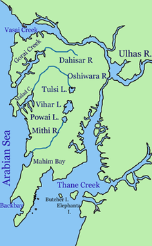
The Ulhas River is a river in Maharashtra, India. It is in the Thane, Raigad, and Pune districts of that state. It flows north and west from it source to where it splits into Vasai Creek and Thane Creek, near Thane. The Ulhas divides Salsette Island from the mainland, and is important for the water supply of Mumbai.[1][2][3]
Gallery
-
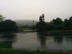 Ulhas River at Kondhana village in Raigad district
 -
 The Ulhas River, as seen from Ghodbunder


See also
 Environment portal
 Ecology portal


References
- ^ Lewis, Clara (18 March 2013). "Greens: Monitor discharge in Ulhas river". Mumbai: Times of India. Retrieved 14 July 2014.
- ^ "District Census Handbook Thane" (PDF). Census of India. 2011. Archived from the original (PDF) on 16 November 2020.
- ^ "MAHARASHTRA - DISTRICT CENSUS HANDBOOK" (PDF). Archived from the original (PDF) on 14 November 2016.
Wikivoyage has a travel guide for Mumbai.
- v
- t
- e
Mumbai topics
- Powai Lake
- Vihar Lake
- Tulsi Lake
- Thane Creek
- Mahim Bay
- Back Bay
- Mithi River
- Ulhas River
- Gilbert Hill
- Malabar Hill
- Salsette Island
- Mumbai Harbour
- Middle Ground
- Climate
- Beaches
- Eastern Suburbs
- Western Suburbs
- South Mumbai
- Neighbourhoods
- Architecture of Mumbai
- Gateway of India
- Chhatrapati Shivaji Terminus
- Naval Dockyard
- Bombay Stock Exchange
- Hutatma Chowk
- General Post Office
- Shreepati Arcade
- Siddhivinayak Temple
- Regal Cinema
- Mount Mary's Church
- Haji Ali Dargah
- Flora Fountain
- David Sassoon Library
- Mumba Devi Temple
- Mahalaxmi Temple
- Chhatrapati Shivaji Maharaj Vastu Sangrahalaya (Prince of Wales Museum)
- National Gallery of Modern Art
- The Asiatic Society of Mumbai
- Jehangir Art Gallery
- Gowalia Tank
- Shri Swaminarayan Mandir
- Mahim Church
- Usha Kiran Building
- Jinnah Mansion
- Brihanmumbai Electric Supply and Transport (BEST)
- Mumbai Suburban Railway
- Central Line
- Harbour Line
- Port Line
- Trans-Harbour Line
- Western Line
- Central Railway
- Western Railway
- Chhatrapati Shivaji Maharaj International Airport
- Bandra Terminus and suburban station
- Chhatrapati Shivaji Terminus
- Dadar railway station and suburban station
- Lokmanya Tilak Terminus
- Mumbai Central railway station
- Juhu Aerodrome
- Auto rickshaw
- Metro
- Line 1
- Line 2
- Line 3
- Line 4
- Line 5
- Line 6
- Line 7
- Line 8
- Line 9
- Line 10
- Line 11
- Line 12
- Line 13
- Monorail
- Skywalk
- Western railway elevated corridor
- Water transport
- Mumbai Bus Rapid Transit System
- Mumbai Urban Transport Project
- Airoli Bridge
- Altamount Road
- Bandra–Worli Sea Link
- Carmichael Road
- Colaba Causeway
- Coastal Road (under construction)
- Currey Road Bridge
- Dadabhai Naoroji Road
- Eastern Express Highway
- Eastern Freeway
- Fashion Street
- Hughes Road
- Jeejabai Bhosle Marg
- JVLR
- Kalwa Bridge
- Linking Road
- Lady Jamshetjee Road
- LBS Marg
- Lamington Road
- Mahim Causeway
- Marine Drive
- MTHL
- Nepean Sea Road
- P D'Mello Road
- Pedder Road
- Princess Street
- SCLR
- SV Road
- Sahar Elevated Access Road
- Sion Panvel Highway
- Vashi Bridge
- Versova–Bandra Sea Link
- Veera Desai Road
- Western Express Highway
and research
 Category
 Commons

19°18′N 72°50′E / 19.300°N 72.833°E / 19.300; 72.833
 | This article about a location in the Indian state of Maharashtra is a stub. You can help Wikipedia by expanding it. |
- v
- t
- e
This article related to a river in India is a stub. You can help Wikipedia by expanding it. |
- v
- t
- e


