National Register of Historic Places listings in Washington County, Oklahoma

This is a list of the National Register of Historic Places listings in Washington County, Oklahoma.
This is intended to be a complete list of the properties and districts on the National Register of Historic Places in Washington County, Oklahoma, United States. The locations of National Register properties and districts for which the latitude and longitude coordinates are included below, may be seen in a map.[1]
There are 11 properties and districts listed on the National Register in the county, including 1 National Historic Landmark. Another property was once listed but has since been removed.
This National Park Service list is complete through NPS recent listings posted September 5, 2024.[2]
Map all coordinates using OpenStreetMap
Download coordinates as:
- KML
- GPX (all coordinates)
- GPX (primary coordinates)
- GPX (secondary coordinates)
Current listings
| [3] | Name on the Register[4] | Image | Date listed[5] | Location | City or town | Description |
|---|---|---|---|---|---|---|
| 1 | Bartlesville Downtown Historic District |  | December 27, 1991 (#91001905) | Roughly bounded by SE. 2nd St., SE. Cherokee Ave., SE. 4th St., and the former ATSF railroad tracks 36°45′02″N 95°58′35″W / 36.7506°N 95.9764°W / 36.7506; -95.9764 (Bartlesville Downtown Historic District) | Bartlesville | |
| 2 | C.A. Comer House |  | June 8, 2015 (#15000330) | 1316 North Creek 36°48′21″N 95°56′00″W / 36.8058°N 95.9334°W / 36.8058; -95.9334 (C.A. Comer House) | Dewey | |
| 3 | Dewey Hotel | 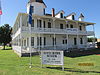 | April 4, 1975 (#75001578) | Delaware and Don Tyler Ave. 36°47′57″N 95°56′15″W / 36.7992°N 95.9375°W / 36.7992; -95.9375 (Dewey Hotel) | Dewey | |
| 4 | First United Methodist Church | Upload image | December 1, 2020 (#100005865) | 500 South Johnstone Ave. 36°44′54″N 95°58′41″W / 36.7483°N 95.9780°W / 36.7483; -95.9780 (First United Methodist Church) | Bartlesville | |
| 5 | House at 1554 SW Rogers | 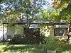 | February 9, 2009 (#09000080) | 1554 SW. Rogers 36°44′05″N 95°59′28″W / 36.7347°N 95.9911°W / 36.7347; -95.9911 (House at 1554 SW Rogers) | Bartlesville | |
| 6 | LaQuinta | 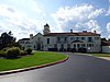 | July 15, 1982 (#82003716) | 2201 Silver Lake Rd. 36°43′03″N 95°57′30″W / 36.7175°N 95.9583°W / 36.7175; -95.9583 (LaQuinta) | Bartlesville | |
| 7 | Nellie Johnstone No. 1 |  | April 11, 1972 (#72001077) | Johnstone Park 36°45′23″N 95°58′19″W / 36.7564°N 95.9719°W / 36.7564; -95.9719 (Nellie Johnstone No. 1) | Bartlesville | |
| 8 | Old Washington County Courthouse |  | January 26, 1981 (#81000469) | 400 Frank Phillips Boulevard 36°45′01″N 95°58′17″W / 36.7503°N 95.9714°W / 36.7503; -95.9714 (Old Washington County Courthouse) | Bartlesville | |
| 9 | Frank and Jane Phillips House |  | March 13, 1975 (#75001576) | 1107 SE. Cherokee Ave. 36°44′31″N 95°58′30″W / 36.7419°N 95.975°W / 36.7419; -95.975 (Frank and Jane Phillips House) | Bartlesville | |
| 10 | Price Tower | 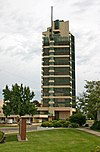 | September 13, 1974 (#74001670) | 510 Dewey Ave. 36°44′51″N 95°58′34″W / 36.7475°N 95.9761°W / 36.7475; -95.9761 (Price Tower) | Bartlesville | Only realized skyscraper designed by Frank Lloyd Wright |
| 11 | Washington County Memorial Hospital |  | March 11, 2014 (#14000055) | 412 SE. Frank Phillips Blvd. 36°45′04″N 95°58′21″W / 36.7510°N 95.9724°W / 36.7510; -95.9724 (Washington County Memorial Hospital) | Bartlesville |
Former listing
| [3] | Name on the Register | Image | Date listed | Date removed | Location | City or town | Description |
|---|---|---|---|---|---|---|---|
| 1 | Civic Center | Upload image | December 29, 1989 (#89002122) | June 3, 2009 | Johnstone Ave. between 6th St. and Adams Boulevard 36°44′49″N 95°58′39″W / 36.7469°N 95.9775°W / 36.7469; -95.9775 (Civic Center) | Bartlesville | Demolished[6][7] |
See also
Wikimedia Commons has media related to National Register of Historic Places in Washington County, Oklahoma.
- List of National Historic Landmarks in Oklahoma
- National Register of Historic Places listings in Oklahoma
References
- ^ The latitude and longitude information provided in this table was derived originally from the National Register Information System, which has been found to be fairly accurate for about 99% of listings. Some locations in this table may have been corrected to current GPS standards.
- ^ National Park Service, United States Department of the Interior, "National Register of Historic Places: Weekly List Actions", retrieved September 5, 2024.
- ^ a b Numbers represent an alphabetical ordering by significant words. Various colorings, defined here, differentiate National Historic Landmarks and historic districts from other NRHP buildings, structures, sites or objects.
- ^ "National Register Information System". National Register of Historic Places. National Park Service. March 13, 2009.
- ^ The eight-digit number below each date is the number assigned to each location in the National Register Information System database, which can be viewed by clicking the number.
- ^ Encyclopedia of Oklahoma History and Culture
- ^ http://www.ocgi.okstate.edu/shpo/shpopic.asp?id=89002122 [dead link]
- v
- t
- e
- Bartlesville Downtown Historic District
- House at 1554 SW Rogers
- LaQuinta
- Nellie Johnstone No. 1
- Old Washington County Courthouse
- Phillips House
- Price Tower
- Washington County Memorial Hospital

- C.A. Comer House
- Dewey Hotel
See also: National Register of Historic Places listings in Washington County, Oklahoma and List of National Historic Landmarks in Oklahoma
| |
|---|---|
| Topics | |
| Lists by state |
|
| Lists by insular areas | |
| Lists by associated state | |
| Other areas | |
| Related | |
| |


Municipalities and communities of Washington County, Oklahoma, United States | ||
|---|---|---|
County seat: Bartlesville | ||
| Cities |  | |
| Towns | ||
| Indian reservation | ||
| Footnotes | ‡This populated place also has portions in an adjacent county or counties | |
| ||


