National Register of Historic Places listings in Kingfisher County, Oklahoma

This is a list of the National Register of Historic Places listings in Kingfisher County, Oklahoma.
This is intended to be a complete list of the properties on the National Register of Historic Places in Kingfisher County, Oklahoma, United States. The locations of National Register properties for which the latitude and longitude coordinates are included below, may be seen in a map.[1]
There are 10 properties listed on the National Register in the county.
This National Park Service list is complete through NPS recent listings posted September 5, 2024.[2]
Map all coordinates using OpenStreetMap
Download coordinates as:
- KML
- GPX (all coordinates)
- GPX (primary coordinates)
- GPX (secondary coordinates)
Current listings
| [3] | Name on the Register[4] | Image | Date listed[5] | Location | City or town | Description |
|---|---|---|---|---|---|---|
| 1 | Burrus Mills Elevator C | Upload image | June 2, 2000 (#00000621) | Northeastern corner of the junction of Admire Ave. and 4th St. 35°51′48″N 97°55′41″W / 35.863333°N 97.928056°W / 35.863333; -97.928056 (Burrus Mills Elevator C) | Kingfisher | |
| 2 | Dow Grain Company Elevator |  | August 31, 2000 (#00001041) | 105 E. Oklahoma St. 35°43′33″N 97°58′22″W / 35.725833°N 97.972778°W / 35.725833; -97.972778 (Dow Grain Company Elevator) | Okarche | |
| 3 | Farmers and Merchants National Bank | Upload image | February 23, 1984 (#84003085) | 107 S. Main St. 36°06′32″N 97°53′54″W / 36.108889°N 97.898333°W / 36.108889; -97.898333 (Farmers and Merchants National Bank) | Hennessey | |
| 4 | Farmers Co-op Elevator | Upload image | August 31, 2000 (#00001042) | 121 W. Kansas St. 36°06′39″N 97°54′00″W / 36.110833°N 97.9°W / 36.110833; -97.9 (Farmers Co-op Elevator) | Hennessey | |
| 5 | Kiel-Dover Farmers Elevator | Upload image | August 31, 2000 (#00001043) | Junction of E. Chestnut St. and the railroad line 35°58′44″N 97°54′47″W / 35.978889°N 97.913056°W / 35.978889; -97.913056 (Kiel-Dover Farmers Elevator) | Dover | |
| 6 | Kingfisher Armory |  | April 7, 1994 (#94000279) | 301 N. 6th St. 35°51′48″N 97°55′50″W / 35.863333°N 97.930556°W / 35.863333; -97.930556 (Kingfisher Armory) | Kingfisher | |
| 7 | Kingfisher College Site | Upload image | October 22, 1976 (#76001566) | 1 mile east of Kingfisher 35°52′04″N 97°54′31″W / 35.867778°N 97.908611°W / 35.867778; -97.908611 (Kingfisher College Site) | Kingfisher | |
| 8 | Kingfisher Memorial Hall | Upload image | June 8, 2006 (#06000487) | 123 W. Miles Ave. 35°51′43″N 97°56′01″W / 35.861944°N 97.933611°W / 35.861944; -97.933611 (Kingfisher Memorial Hall) | Kingfisher | |
| 9 | Kingfisher Post Office |  | January 20, 1978 (#78002239) | 406 N. Main St. 35°51′52″N 97°55′59″W / 35.8644°N 97.9330°W / 35.8644; -97.9330 (Kingfisher Post Office) | Kingfisher | |
| 10 | Seay Mansion | 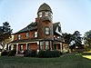 | March 24, 1971 (#71000664) | 11th St. and Zellers Ave. 35°50′56″N 97°56′21″W / 35.8490°N 97.9393°W / 35.8490; -97.9393 (Seay Mansion) | Kingfisher |
See also
Wikimedia Commons has media related to National Register of Historic Places in Kingfisher County, Oklahoma.
- List of National Historic Landmarks in Oklahoma
- National Register of Historic Places listings in Oklahoma
References
- ^ The latitude and longitude information provided in this table was derived originally from the National Register Information System, which has been found to be fairly accurate for about 99% of listings. Some locations in this table may have been corrected to current GPS standards.
- ^ National Park Service, United States Department of the Interior, "National Register of Historic Places: Weekly List Actions", retrieved September 5, 2024.
- ^ Numbers represent an alphabetical ordering by significant words. Various colorings, defined here, differentiate National Historic Landmarks and historic districts from other NRHP buildings, structures, sites or objects.
- ^ "National Register Information System". National Register of Historic Places. National Park Service. March 13, 2009.
- ^ The eight-digit number below each date is the number assigned to each location in the National Register Information System database, which can be viewed by clicking the number.
For more information on the Seay Mansion, go to http://www.ctokmuseum.org/
- v
- t
- e
- List of U.S. National Historic Landmarks by state:
- Alabama
- Alaska
- Arizona
- Arkansas
- California
- Colorado
- Connecticut
- Delaware
- Florida
- Georgia
- Hawaii
- Idaho
- Illinois
- Indiana
- Iowa
- Kansas
- Kentucky
- Louisiana
- Maine
- Maryland
- Massachusetts
- Michigan
- Minnesota
- Mississippi
- Missouri
- Montana
- Nebraska
- Nevada
- New Hampshire
- New Jersey
- New Mexico
- New York
- North Carolina
- North Dakota
- Ohio
- Oklahoma
- Oregon
- Pennsylvania
- Rhode Island
- South Carolina
- South Dakota
- Tennessee
- Texas
- Utah
- Vermont
- Virginia
- Washington
- West Virginia
- Wisconsin
- Wyoming
 National Register of Historic Places portal
 Category


