National Register of Historic Places listings in Turner County, Georgia
This is a list of properties and districts in Turner County, Georgia that are listed on the National Register of Historic Places (NRHP).
Map all coordinates using OpenStreetMap
Download coordinates as:
- KML
- GPX (all coordinates)
- GPX (primary coordinates)
- GPX (secondary coordinates)
This National Park Service list is complete through NPS recent listings posted June 21, 2024.[1]
- v
- t
- e
Properties on the National Register of Historic Places in Georgia by county
- Appling
- Atkinson
- Bacon
- Baker
- Baldwin
- Banks
- Barrow
- Bartow
- Ben Hill
- Berrien
- Bibb
- Bleckley
- Brantley
- Brooks
- Bryan
- Bulloch
- Burke
- Butts
- Calhoun
- Camden
- Candler
- Carroll
- Catoosa
- Charlton
- Chatham
- Chattahoochee
- Chattooga
- Cherokee
- Clarke
- Clay
- Clayton
- Clinch
- Cobb
- Coffee
- Colquitt
- Columbia
- Cook
- Coweta
- Crawford
- Crisp
- Dade
- Dawson
- Decatur
- DeKalb
- Dodge
- Dooly
- Dougherty
- Douglas
- Early
- Echols
- Effingham
- Elbert
- Emanuel
- Evans
- Fannin
- Fayette
- Floyd
- Forsyth
- Franklin
- Fulton
- Gilmer
- Glascock
- Glynn
- Gordon
- Grady
- Greene
- Gwinnett
- Habersham
- Hall
- Hancock
- Haralson
- Harris
- Hart
- Heard
- Henry
- Houston
- Irwin
- Jackson
- Jasper
- Jeff Davis
- Jefferson
- Jenkins
- Johnson
- Jones
- Lamar
- Lanier
- Laurens
- Lee
- Liberty
- Lincoln
- Long
- Lowndes
- Lumpkin
- Macon
- Madison
- Marion
- McDuffie
- McIntosh
- Meriwether
- Miller
- Mitchell
- Monroe
- Montgomery
- Morgan
- Murray
- Muscogee
- Newton
- Oconee
- Oglethorpe
- Paulding
- Peach
- Pickens
- Pierce
- Pike
- Polk
- Pulaski
- Putnam
- Quitman
- Rabun
- Randolph
- Richmond
- Rockdale
- Schley
- Screven
- Seminole
- Spalding
- Stephens
- Stewart
- Sumter
- Talbot
- Taliaferro
- Tattnall
- Taylor
- Telfair
- Terrell
- Thomas
- Tift
- Toombs
- Towns
- Treutlen
- Troup
- Turner
- Twiggs
- Union
- Upson
- Walker
- Walton
- Ware
- Warren
- Washington
- Wayne
- Webster
- Wheeler
- White
- Whitfield
- Wilcox
- Wilkes
- Wilkinson
- Worth

Current listings
| [2] | Name on the Register | Image | Date listed[3] | Location | City or town | Description |
|---|---|---|---|---|---|---|
| 1 | Ashburn Commercial Historic District |  | August 18, 1992 (#92001042) | Roughly, Main St. between Murray and Monroe Aves. 31°42′23″N 83°39′13″W / 31.706389°N 83.653611°W / 31.706389; -83.653611 (Ashburn Commercial Historic District) | Ashburn | |
| 2 | Ashburn Heights-Hudson-College Avenue Historic District |  | October 22, 1992 (#92001411) | Roughly bounded by McLendon, Phillips, Monnie, Hudson and College Aves. 31°42′41″N 83°38′59″W / 31.711389°N 83.649722°W / 31.711389; -83.649722 (Ashburn Heights-Hudson-College Avenue Historic District) | Ashburn | |
| 3 | Shingler Heights Historic District |  | November 12, 1992 (#92001571) | N. Main St. (US 41) between Murray and Hill Aves. 31°42′48″N 83°39′26″W / 31.713333°N 83.657222°W / 31.713333; -83.657222 (Shingler Heights Historic District) | Ashburn | |
| 4 | Turner County Courthouse |  | September 18, 1980 (#80001247) | Courthouse Sq. 31°42′28″N 83°39′11″W / 31.707778°N 83.653056°W / 31.707778; -83.653056 (Turner County Courthouse) | Ashburn | Built 1907-08 |
| 5 | Turner County Jail | 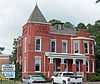 | August 26, 1982 (#82002490) | 200 College St. 31°42′29″N 83°39′08″W / 31.708056°N 83.652222°W / 31.708056; -83.652222 (Turner County Jail) | Ashburn | Built 1906-07 |
| 6 | Wesleyan Methodist Campground and Tabernacle |  | December 12, 1998 (#98001485) | 321 Gordon St. 31°42′12″N 83°39′00″W / 31.703333°N 83.65°W / 31.703333; -83.65 (Wesleyan Methodist Campground and Tabernacle) | Ashburn |
References
- ^ National Park Service, United States Department of the Interior, "National Register of Historic Places: Weekly List Actions", retrieved June 21, 2024.
- ^ Numbers represent an alphabetical ordering by significant words. Various colorings, defined here, differentiate National Historic Landmarks and historic districts from other NRHP buildings, structures, sites or objects.
- ^ The eight-digit number below each date is the number assigned to each location in the National Register Information System database, which can be viewed by clicking the number.
Wikimedia Commons has media related to National Register of Historic Places in Turner County, Georgia.
| |
|---|---|
| Topics | |
| Lists by state |
|
| Lists by insular areas | |
| Lists by associated state | |
| Other areas | |
| Related | |
| |


