National Register of Historic Places listings in Dooly County, Georgia

This is a list of properties and districts in Dooly County, Georgia that are listed on the National Register of Historic Places (NRHP).
Map all coordinates using OpenStreetMap
Download coordinates as:
- KML
- GPX (all coordinates)
- GPX (primary coordinates)
- GPX (secondary coordinates)
This National Park Service list is complete through NPS recent listings posted June 21, 2024.[1]
- v
- t
- e
Properties on the National Register of Historic Places in Georgia by county
- Appling
- Atkinson
- Bacon
- Baker
- Baldwin
- Banks
- Barrow
- Bartow
- Ben Hill
- Berrien
- Bibb
- Bleckley
- Brantley
- Brooks
- Bryan
- Bulloch
- Burke
- Butts
- Calhoun
- Camden
- Candler
- Carroll
- Catoosa
- Charlton
- Chatham
- Chattahoochee
- Chattooga
- Cherokee
- Clarke
- Clay
- Clayton
- Clinch
- Cobb
- Coffee
- Colquitt
- Columbia
- Cook
- Coweta
- Crawford
- Crisp
- Dade
- Dawson
- Decatur
- DeKalb
- Dodge
- Dooly
- Dougherty
- Douglas
- Early
- Echols
- Effingham
- Elbert
- Emanuel
- Evans
- Fannin
- Fayette
- Floyd
- Forsyth
- Franklin
- Fulton
- Gilmer
- Glascock
- Glynn
- Gordon
- Grady
- Greene
- Gwinnett
- Habersham
- Hall
- Hancock
- Haralson
- Harris
- Hart
- Heard
- Henry
- Houston
- Irwin
- Jackson
- Jasper
- Jeff Davis
- Jefferson
- Jenkins
- Johnson
- Jones
- Lamar
- Lanier
- Laurens
- Lee
- Liberty
- Lincoln
- Long
- Lowndes
- Lumpkin
- Macon
- Madison
- Marion
- McDuffie
- McIntosh
- Meriwether
- Miller
- Mitchell
- Monroe
- Montgomery
- Morgan
- Murray
- Muscogee
- Newton
- Oconee
- Oglethorpe
- Paulding
- Peach
- Pickens
- Pierce
- Pike
- Polk
- Pulaski
- Putnam
- Quitman
- Rabun
- Randolph
- Richmond
- Rockdale
- Schley
- Screven
- Seminole
- Spalding
- Stephens
- Stewart
- Sumter
- Talbot
- Taliaferro
- Tattnall
- Taylor
- Telfair
- Terrell
- Thomas
- Tift
- Toombs
- Towns
- Treutlen
- Troup
- Turner
- Twiggs
- Union
- Upson
- Walker
- Walton
- Ware
- Warren
- Washington
- Wayne
- Webster
- Wheeler
- White
- Whitfield
- Wilcox
- Wilkes
- Wilkinson
- Worth

Current listings
| [2] | Name on the Register | Image | Date listed[3] | Location | City or town | Description |
|---|---|---|---|---|---|---|
| 1 | William H. Byrom House |  | February 14, 1997 (#97000053) | Main St., near the jct. of GA 90 and the Seaboard Coast RR 32°12′05″N 83°54′24″W / 32.20127°N 83.90679°W / 32.20127; -83.90679 (William H. Byrom House) | Dooly | |
| 2 | County Training School |  | April 7, 2010 (#10000158) | 190 Ninth St. 32°05′31″N 83°47′05″W / 32.091953°N 83.784844°W / 32.091953; -83.784844 (County Training School) | Vienna | Apparently demolished. Likely location 32°05′28″N 83°47′04″W / 32.0912°N 83.7844°W / 32.0912; -83.7844 |
| 3 | Dooly County Campground | Upload image | March 1, 2024 (#100009997) | 21 Parsonage Road 32°06′51″N 83°50′09″W / 32.1142°N 83.8359°W / 32.1142; -83.8359 (Dooly County Campground) | Vienna vicinity | |
| 4 | Dooly County Courthouse |  | September 18, 1980 (#80001013) | GA 27 32°05′28″N 83°47′51″W / 32.09109°N 83.7975°W / 32.09109; -83.7975 (Dooly County Courthouse) | Vienna | |
| 5 | Leonard-Akin House | 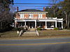 | February 14, 1997 (#97000054) | 309 E. Union St. 32°05′28″N 83°47′28″W / 32.09117°N 83.79121°W / 32.09117; -83.79121 (Leonard-Akin House) | Vienna | |
| 6 | Lilly Historic District |  | January 5, 1998 (#97001558) | Roughly bounded by CSX RR tracks, and Church, Montezuma, Third, and School Sts. 32°08′54″N 83°52′41″W / 32.148333°N 83.878056°W / 32.148333; -83.878056 (Lilly Historic District) | Lilly | |
| 7 | Stovall-George-Woodward House |  | April 27, 1979 (#79000716) | 305 Union St. 32°05′28″N 83°47′30″W / 32.091111°N 83.791667°W / 32.091111; -83.791667 (Stovall-George-Woodward House) | Vienna | |
| 8 | Vienna High and Industrial School |  | December 19, 2012 (#12001056) | 216 9th St. 32°05′36″N 83°47′00″W / 32.0932°N 83.7834°W / 32.0932; -83.7834 (Vienna High and Industrial School) | Vienna | |
| 9 | Vienna Historic District |  | January 28, 2005 (#04001557) | Roughly centered on the downtown commercial district and includes residential areas and the rail line 32°05′34″N 83°47′33″W / 32.092778°N 83.7925°W / 32.092778; -83.7925 (Vienna Historic District) | Vienna |
References
- ^ National Park Service, United States Department of the Interior, "National Register of Historic Places: Weekly List Actions", retrieved June 21, 2024.
- ^ Numbers represent an alphabetical ordering by significant words. Various colorings, defined here, differentiate National Historic Landmarks and historic districts from other NRHP buildings, structures, sites or objects.
- ^ The eight-digit number below each date is the number assigned to each location in the National Register Information System database, which can be viewed by clicking the number.
Wikimedia Commons has media related to National Register of Historic Places in Dooly County, Georgia.
| |
|---|---|
| Topics | |
| Lists by state |
|
| Lists by insular areas | |
| Lists by associated state | |
| Other areas | |
| Related | |
| |


