List of the major 100-kilometer summits of North America

The following sortable table comprises the 230 mountain peaks of greater North America[1] with at least 100 kilometers (62.14 miles) of topographic isolation and at least 500 meters (1640 feet) of topographic prominence.[2]
The summit of a mountain or hill may be measured in three principal ways:
- The topographic elevation of a summit measures the height of the summit above a geodetic sea level.[3][4]
- The topographic prominence of a summit is a measure of how high the summit rises above its surroundings.[5][4]
- The topographic isolation (or radius of dominance) of a summit measures how far the summit lies from its nearest point of equal elevation.[6]
Denali is one of only three summits on Earth with more than 6000 kilometers (3728 miles) of topographic isolation. Four major summits of greater North America exceed 2000 kilometers (1243 miles), eight exceed 1000 kilometers (621.4 miles), 35 exceed 500 kilometers (310.7 miles), 107 exceed 200 kilometers (124.3 miles), the following 230 major summits exceed 100 kilometers (62.14 miles), and 413 exceed 50 kilometers (31.07 miles) of topographic isolation.
Major 100-kilometer summits
Map this section's coordinates using OpenStreetMap
Download coordinates as:
- KML
- GPX (all coordinates)
- GPX (primary coordinates)
- GPX (secondary coordinates)
Of these 230 major 100-kilometer summits of North America, 103 are located in the United States (excluding four in Hawaiʻi), 50 in Canada, 33 in México, 21 in Greenland, four in Honduras, three in Cuba, two in Guatemala, two in Haiti, two in Panamá, and one each in the Dominican Republic, Costa Rica, Guadeloupe, Puerto Rico, Jamaica, Saint Kitts and Nevis, Saint Vincent and the Grenadines, Trinidad and Tobago, Nicaragua, Belize, Grenada, and the British Virgin Islands. Two of these peaks lie on the Canada-United States border and one lies on the Nicaragua-Honduras border.
| Rank | Mountain Peak | Region | Mountain Range | Elevation | Prominence | Isolation | Location |
|---|---|---|---|---|---|---|---|
| 1 | Denali[7][8][a] | Alaska Range | 6190.5 m 20,310 ft | 6141 m 20,146 ft | 7,450.24 | 63°04′08″N 151°00′23″W / 63.0690°N 151.0063°W / 63.0690; -151.0063 (Denali) | |
| 2 | Gunnbjørn Fjeld[9][10][b][c] |  Greenland Greenland | Island of Greenland | 3694 m 12,119 ft | 3694 m 12,119 ft | 3,254.13 | 68°55′06″N 29°53′57″W / 68.9184°N 29.8991°W / 68.9184; -29.8991 (Gunnbjørn Fjeld) |
| 3 | Pico de Orizaba[11][12][d] (Citlaltépetl) |  Puebla Puebla Veracruz Veracruz | Cordillera Neovolcanica | 5636 m 18,491 ft | 4922 m 16,148 ft | 2,690.14 | 19°01′50″N 97°16′11″W / 19.0305°N 97.2698°W / 19.0305; -97.2698 (Pico de Orizaba) |
| 4 | Mount Whitney[13][14][15][e][f] |  California California | Sierra Nevada | 4421 m 14,505 ft | 3072 m 10,080 ft | 2,649.47 | 36°34′43″N 118°17′31″W / 36.5786°N 118.2920°W / 36.5786; -118.2920 (Mount Whitney) |
| 5 | Mount Mitchell[16][17][g][h][i] |  North Carolina North Carolina | Blue Ridge Mountains | 2037 m 6,684 ft | 1857 m 6,092 ft | 1,913.49 | 35°45′54″N 82°15′54″W / 35.7649°N 82.2651°W / 35.7649; -82.2651 (Mount Mitchell) |
| 6 | Mount Washington[18][19][20][j][k][l] |  New Hampshire New Hampshire | White Mountains | 1917 m 6,288 ft | 1877 m 6,158 ft | 1,318.95 | 44°16′14″N 71°18′12″W / 44.2705°N 71.3032°W / 44.2705; -71.3032 (Mount Washington) |
| 7 | Mount Rainier[21][22][m][n] |  Washington Washington | Cascade Range | 4394 m 14,417 ft | 4026 m 13,210 ft | 1,176.72 | 46°51′10″N 121°45′37″W / 46.8529°N 121.7604°W / 46.8529; -121.7604 (Mount Rainier) |
| 8 | Mount Elbert[23][24][25][o] |  Colorado Colorado | Sawatch Range | 4401.2 m 14,440 ft | 2772 m 9,093 ft | 1,079.15 | 39°07′04″N 106°26′43″W / 39.1178°N 106.4454°W / 39.1178; -106.4454 (Mount Elbert) |
| 9 | Pico Duarte[26][p] |  Dominican Republic Dominican Republic | Cordillera Central, Hispaniola | 3098 m 10,164 ft | 3098 m 10,164 ft | 941 km 584 mi | 19°01′23″N 70°59′52″W / 19.0231°N 70.9977°W / 19.0231; -70.9977 (Pico Duarte) |
| 10 | Chirripó Grande[27][q][r] (Cerro Chirripó) |  Costa Rica Costa Rica | Cordillera de Talamanca | 3819 m 12,530 ft | 3755 m 12,320 ft | 878 km 546 mi | 9°29′03″N 83°29′20″W / 9.4843°N 83.4889°W / 9.4843; -83.4889 (Chirripó Grande) |
| 11 | Shishaldin Volcano[28][29][s][t] | Unimak Island | 2869 m 9,414 ft | 2869 m 9,414 ft | 877 km 545 mi | 54°45′19″N 163°58′15″W / 54.7554°N 163.9709°W / 54.7554; -163.9709 (Shishaldin Volcano) | |
| 12 | Barbeau Peak[30][31][u][v] |  Nunavut Nunavut | Ellesmere Island | 2616 m 8,583 ft | 2616 m 8,583 ft | 796 km 495 mi | 81°54′53″N 75°00′33″W / 81.9148°N 75.0093°W / 81.9148; -75.0093 (Barbeau Peak) |
| 13 | Mount Caubvick[32][33][w] (Mont d'Iberville) |  Newfoundland and Labrador Newfoundland and Labrador | Torngat Mountains | 1652 m 5,420 ft | 1367 m 4,485 ft | 791 km 492 mi | 58°53′16″N 63°42′35″W / 58.8878°N 63.7098°W / 58.8878; -63.7098 (Mount Caubvick) |
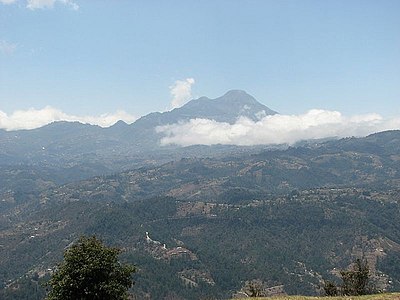
| 14 | Volcán Tajumulco[34][x][y] |  Guatemala Guatemala | Sierra de las Nubes | 4220 m 13,845 ft | 3990 m 13,091 ft | 722 km 448 mi | 15°02′35″N 91°54′13″W / 15.0430°N 91.9037°W / 15.0430; -91.9037 (Volcán Tajumulco) |
| 15 | Melville Island High Point[35] | Nunavut | Melville Island | 762 m 2,500 ft | 762 m 2,500 ft | 717 km 445 mi | 75°22′10″N 115°04′58″W / 75.3694°N 115.0827°W / 75.3694; -115.0827 (Melville Island High Point) |
| 16 | La Grande Soufrière[36][z][aa] |  Guadeloupe Guadeloupe | île de Basse-Terre | 1467 m 4,813 ft | 1467 m 4,813 ft | 699 km 434 mi | 16°02′42″N 61°39′50″W / 16.0449°N 61.6638°W / 16.0449; -61.6638 (La Grande Soufrière) |
| 17 | Tanaga Volcano[37][38][ab][ac] | Tanaga Island | 1806 m 5,925 ft | 1806 m 5,925 ft | 656 km 407 mi | 51°53′02″N 178°08′34″W / 51.8838°N 178.1429°W / 51.8838; -178.1429 (Tanaga Volcano) | |
| 18 | Avannaarsua High Point[39][ad] | Greenland | Island of Greenland | 2600 m 8,530 ft | 500 m 1,640 ft | 636 km 395 mi | 77°30′00″N 47°37′00″W / 77.5000°N 47.6167°W / 77.5000; -47.6167 (Avannaarsua High Point) |
| 19 | Mount Isto[40][41][ae][af] | Brooks Range | 2736 m 8,976 ft | 2408 m 7,901 ft | 634 km 394 mi | 69°12′09″N 143°48′07″W / 69.2025°N 143.8020°W / 69.2025; -143.8020 (Mount Isto) | |
| 20 | Mathiassen Mountain[42][ag] | Nunavut | Southampton Island | 625 m 2,051 ft | 625 m 2,051 ft | 627 km 390 mi | 64°44′25″N 83°09′26″W / 64.7403°N 83.1573°W / 64.7403; -83.1573 (Mathiassen Mountain) |
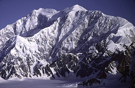
| 21 | Mount Logan[43][44][ah] |  Yukon Yukon | Saint Elias Mountains | 5956 m 19,541 ft | 5247 m 17,215 ft | 623 km 387 mi | 60°34′02″N 140°24′20″W / 60.5671°N 140.4055°W / 60.5671; -140.4055 (Mount Logan) |
| 22 | Angilaaq Mountain[45][46][ai] | Nunavut | Bylot Island | 1944 m 6,378 ft | 1944 m 6,378 ft | 622 km 387 mi | 73°13′47″N 78°37′23″W / 73.2298°N 78.6230°W / 73.2298; -78.6230 (Angilaaq Mountain) |
| 23 | Signal Hill[47][48][aj][ak] (Mount Magazine) |  Arkansas Arkansas | Ouachita Mountains | 839 m 2,753 ft | 653 m 2,143 ft | 613 km 381 mi | 35°10′02″N 93°38′41″W / 35.1671°N 93.6447°W / 35.1671; -93.6447 (Signal Hill) |
| 24 | Mount Odin[49][50][al][am] | Nunavut | Baffin Island | 2143 m 7,031 ft | 2143 m 7,031 ft | 586 km 364 mi | 66°32′48″N 65°25′44″W / 66.5468°N 65.4289°W / 66.5468; -65.4289 (Mount Odin) |
| 25 | Cerro El Potosí[51][52][an] |  Nuevo León Nuevo León | Sierra Madre Oriental | 3720 m 12,205 ft | 1875 m 6,152 ft | 571 km 355 mi | 24°52′19″N 100°13′58″W / 24.8719°N 100.2327°W / 24.8719; -100.2327 (Cerro el Potosí) |
| 26 | Mount Waddington[53][54][ao][ap] |  British Columbia British Columbia | Coast Mountains | 4019 m 13,186 ft | 3289 m 10,791 ft | 562 km 349 mi | 51°22′25″N 125°15′49″W / 51.3737°N 125.2636°W / 51.3737; -125.2636 (Mount Waddington) |
| 27 | Melville Hills High Point[55] |  Northwest Territories Northwest Territories | Melville Hills | 876 m 2,875 ft | 500 m 1,640 ft | 551 km 342 mi | 69°14′33″N 121°32′21″W / 69.2425°N 121.5391°W / 69.2425; -121.5391 (Melville Hills High Point) |
| 28 | Keele Peak[56][57][aq][ar] | Yukon | Mackenzie Mountains | 2952 m 9,685 ft | 2161 m 7,090 ft | 543 km 337 mi | 63°25′53″N 130°19′27″W / 63.4314°N 130.3243°W / 63.4314; -130.3243 (Keele Peak) |
| 29 | Mount Shasta[58][59][60][as] | California | Cascade Range | 4321.8 m 14,179 ft | 2979 m 9,772 ft | 539 km 335 mi | 41°24′33″N 122°11′42″W / 41.4092°N 122.1949°W / 41.4092; -122.1949 (Mount Shasta) |
| 30 | Perserajoq[61] | Greenland | Island of Greenland | 2259 m 7,411 ft | 2009 m 6,591 ft | 527 km 328 mi | 71°24′00″N 51°58′00″W / 71.4000°N 51.9667°W / 71.4000; -51.9667 (Perserajoq) |
| 31 | Mealy Mountains High Point[62][at] | Newfoundland and Labrador | Mealy Mountains | 1190 m 3,904 ft | 832 m 2,728 ft | 519 km 323 mi | 53°38′47″N 58°33′13″W / 53.6465°N 58.5536°W / 53.6465; -58.5536 (Mealy Mountains High Point) |
| 32 | Peary Land High Point[63][au] | Greenland | Island of Greenland | 1910 m 6,266 ft | 500 m 1,640 ft | 509 km 317 mi | 83°19′00″N 35°20′00″W / 83.3167°N 35.3333°W / 83.3167; -35.3333 (Peary Land High Point) |
| 33 | The Cabox[64][65][av][aw] | Newfoundland and Labrador | Island of Newfoundland | 812 m 2,664 ft | 812 m 2,664 ft | 501 km 311 mi | 48°49′59″N 58°29′03″W / 48.8331°N 58.4843°W / 48.8331; -58.4843 (The Cabox) |
| 34 | Volcán Everman[66][ax] |  Colima Colima | Isla Socorro | 1050 m 3,445 ft | 1050 m 3,445 ft | 500 km 311 mi | 18°48′00″N 110°59′00″W / 18.8000°N 110.9833°W / 18.8000; -110.9833 (Volcán Everman) |
| 35 | Greenland Ice Sheet High Point[67][ay] | Greenland | Island of Greenland | 3238 m 10,623 ft | 500 m 1,640 ft | 476 km 296 mi | 72°28′00″N 37°06′00″W / 72.4667°N 37.1000°W / 72.4667; -37.1000 (Greenland Ice Sheet High Point) |
| 36 | Gannett Peak[68][69][70][az][ba] |  Wyoming Wyoming | Wind River Range | 4209.1 m 13,809 ft | 2157 m 7,076 ft | 467 km 290 mi | 43°11′03″N 109°39′15″W / 43.1842°N 109.6542°W / 43.1842; -109.6542 (Gannett Peak) |
| 37 | Mont Yapeitso[71][72][bb] |  Quebec Quebec | Monts Otish | 1135 m 3,725 ft | 500 m 1,640 ft | 467 km 290 mi | 52°19′20″N 70°26′42″W / 52.3223°N 70.4451°W / 52.3223; -70.4451 (Mont Yapeitso) |
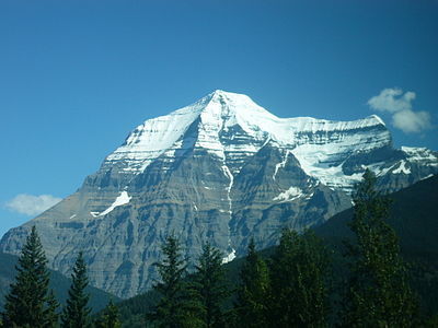
| 38 | Mount Robson[73][74][bc][bd] | British Columbia | Canadian Rockies | 3959 m 12,989 ft | 2829 m 9,281 ft | 460 km 286 mi | 53°06′38″N 119°09′24″W / 53.1105°N 119.1566°W / 53.1105; -119.1566 (Mount Robson) |
| 39 | Mount Osborn[75][76][be] | Seward Peninsula | 1437 m 4,714 ft | 1334 m 4,377 ft | 453 km 282 mi | 64°59′32″N 165°19′46″W / 64.9922°N 165.3294°W / 64.9922; -165.3294 (Mount Osborn) | |
| 40 | Mount Igikpak[77][78][bf] | Brooks Range | 2523 m 8,276 ft | 1867 m 6,126 ft | 453 km 282 mi | 67°24′46″N 154°57′56″W / 67.4129°N 154.9656°W / 67.4129; -154.9656 (Mount Igikpak) | |
| 41 | Ulysses Mountain[79][80][bg][bh] (Mount Ulysses) | British Columbia | Muskwa Ranges | 3024 m 9,921 ft | 2294 m 7,526 ft | 436 km 271 mi | 57°20′47″N 124°05′34″W / 57.3464°N 124.0928°W / 57.3464; -124.0928 (Ulysses Mountain) |
| 42 | Cerro de Punta[81][82][bi] |  Puerto Rico Puerto Rico | Cordillera Central, Island of Puerto Rico | 1338 m 4,389 ft | 1338 m 4,389 ft | 432 km 268 mi | 18°10′20″N 66°35′30″W / 18.1722°N 66.5917°W / 18.1722; -66.5917 (Cerro de Punta) |
| 43 | Cerro Gordo[83][84][bj][bk] |  Durango Durango | Sierra Madre Occidental | 3357 m 11,014 ft | 1387 m 4,551 ft | 424 km 263 mi | 23°12′22″N 104°56′39″W / 23.2060°N 104.9442°W / 23.2060; -104.9442 (Cerro Gordo) |
| 44 | Pico San Juan[85][bl] |  Cuba Cuba | Sierra Maestra, Island of Cuba | 1140 m 3,740 ft | 500 m 1,640 ft | 408 km 253 mi | 21°59′07″N 80°07′58″W / 21.9853°N 80.1327°W / 21.9853; -80.1327 (Pico San Juan) |
| 45 | Mont Jacques-Cartier[86][87][bm][bn] | Quebec | Chic-Choc Mountains | 1268 m 4,160 ft | 1093 m 3,585 ft | 406 km 252 mi | 48°59′16″N 65°56′54″W / 48.9879°N 65.9483°W / 48.9879; -65.9483 (Mont Jacques-Cartier) |
| 46 | Nevado de Colima[88][89][bo][bp] |  Jalisco Jalisco | Cordillera Neovolcanica | 4270 m 14,009 ft | 2720 m 8,924 ft | 405 km 252 mi | 19°33′48″N 103°36′31″W / 19.5633°N 103.6087°W / 19.5633; -103.6087 (Nevado de Colima) |
| 47 | Sukkertoppen[90][bq] | Greenland | Island of Greenland | 2440 m 8,005 ft | 500 m 1,640 ft | 401 km 249 mi | 66°12′00″N 52°21′00″W / 66.2000°N 52.3500°W / 66.2000; -52.3500 (Sukkertoppen) |
| 48 | Humphreys Peak[91][92][br][bs] |  Arizona Arizona | San Francisco Peaks | 3852 m 12,637 ft | 1841 m 6,039 ft | 396 km 246 mi | 35°20′47″N 111°40′41″W / 35.3464°N 111.6780°W / 35.3464; -111.6780 (Humphreys Peak) |
| 49 | Haffner Bjerg[93][bt] | Greenland | Island of Greenland | 1050 m 3,445 ft | 500 m 1,640 ft | 393 km 244 mi | 76°20′33″N 62°20′43″W / 76.3426°N 62.3453°W / 76.3426; -62.3453 (Haffner Bjerg) |
| 50 | Victoria Island High Point[94] | Nunavut | Victoria Island | 655 m 2,149 ft | 655 m 2,149 ft | 375 km 233 mi | 71°51′10″N 112°36′26″W / 71.8528°N 112.6073°W / 71.8528; -112.6073 (Victoria Island High Point) |
| 51 | Wheeler Peak[95][96][97][bu] |  Nevada Nevada | Snake Range | 3982.3 m 13,065 ft | 2307 m 7,568 ft | 373 km 232 mi | 38°59′09″N 114°18′50″W / 38.9858°N 114.3139°W / 38.9858; -114.3139 (Wheeler Peak) |
| 52 | Reval Toppen[98] | Greenland | Island of Greenland | 2320 m 7,612 ft | 500 m 1,640 ft | 368 km 229 mi | 76°39′38″N 25°42′24″W / 76.6606°N 25.7067°W / 76.6606; -25.7067 (Reval Toppen) |
| 53 | Kisimngiuqtuq Peak[99][100] | Nunavut | Baffin Island | 1905 m 6,250 ft | 1605 m 5,266 ft | 362 km 225 mi | 70°47′57″N 71°39′01″W / 70.7993°N 71.6502°W / 70.7993; -71.6502 (Kisimngiuqtuq Peak) |
| 54 | Mount Vsevidof[101][102][bv][bw] | Umnak Island | 2149 m 7,051 ft | 2149 m 7,051 ft | 358 km 223 mi | 53°07′32″N 168°41′38″W / 53.1256°N 168.6938°W / 53.1256; -168.6938 (Mount Vsevidof) | |
| 55 | Mont Forel[103][bx] | Greenland | Island of Greenland | 3391 m 11,125 ft | 1581 m 5,187 ft | 357 km 222 mi | 66°56′07″N 36°47′14″W / 66.9354°N 36.7873°W / 66.9354; -36.7873 (Mont Forel) |
| 56 | Beitstad Peak[104][105] | Nunavut | Ellesmere Island | 2347 m 7,700 ft | 2044 m 6,706 ft | 354 km 220 mi | 78°48′03″N 79°31′45″W / 78.8007°N 79.5292°W / 78.8007; -79.5292 (Beitstad Peak) |
| 57 | Hahn Land High Point[106][by] | Greenland | Island of Greenland | 1744 m 5,722 ft | 1694 m 5,558 ft | 347 km 216 mi | 80°26′00″N 19°50′00″W / 80.4333°N 19.8333°W / 80.4333; -19.8333 (Hahn Land High Point) |
| 58 | Pico La Laguna[107][108][bz] |  Baja California Sur Baja California Sur | Sierra La Laguna | 2090 m 6,857 ft | 1920 m 6,299 ft | 343 km 213 mi | 23°32′21″N 109°57′15″W / 23.5392°N 109.9542°W / 23.5392; -109.9542 (Pico La Laguna) |
| 59 | Volcán Las Tres Vírgenes[109] | Baja California Sur | Tres Virgenes | 1951 m 6,401 ft | 1626 m 5,335 ft | 340 km 211 mi | 27°28′12″N 112°35′31″W / 27.4700°N 112.5919°W / 27.4700; -112.5919 (Volcán Las Tres Vírgenes) |
| 60 | Isla Guadalupe High Point[110][ca] |  Baja California Baja California | Isla Guadalupe | 1310 m 4,298 ft | 1310 m 4,298 ft | 340 km 211 mi | 29°06′06″N 118°18′48″W / 29.1016°N 118.3132°W / 29.1016; -118.3132 (Isla Guadalupe High Point) |
| 61 | Mount Veniaminof[111][112][cb] | Alaska Peninsula | 2507 m 8,225 ft | 2499 m 8,200 ft | 337 km 209 mi | 56°13′10″N 159°17′51″W / 56.2194°N 159.2975°W / 56.2194; -159.2975 (Mount Veniaminof) | |
| 62 | Picacho del Diablo[113][114][cc][cd] | Baja California | Sierra de San Pedro Mártir | 3095 m 10,154 ft | 2125 m 6,972 ft | 335 km 208 mi | 30°59′33″N 115°22′31″W / 30.9925°N 115.3753°W / 30.9925; -115.3753 (Picacho del Diablo) |
| 63 | Cerro el Nacimiento[115][116][ce] |  Oaxaca Oaxaca | Sierra Madre del Sur | 3710 m 12,172 ft | 2140 m 7,021 ft | 329 km 205 mi | 16°12′41″N 96°11′48″W / 16.2115°N 96.1967°W / 16.2115; -96.1967 (Cerro el Nacimiento) |
| 64 | Mount Ratz[117][118][cf] | British Columbia | Coast Mountains | 3090 m 10,138 ft | 2430 m 7,972 ft | 311 km 193.4 mi | 57°23′35″N 132°18′11″W / 57.3930°N 132.3031°W / 57.3930; -132.3031 (Mount Ratz) |
| 65 | Hall Island High Point[119] | Hall Island | 507 m 1,665 ft | 507 m 1,665 ft | 310 km 192.9 mi | 60°39′53″N 173°05′19″W / 60.6647°N 173.0887°W / 60.6647; -173.0887 (Hall Island High Point) | |
| 66 | Kuskokwim High Point[120][cg] | Kuskokwim Mountains | 1600 m 5,250 ft | 1364 m 4,475 ft | 308 km 191.6 mi | 60°06′57″N 159°19′27″W / 60.1159°N 159.3241°W / 60.1159; -159.3241 (Kuskokwim High Point) | |
| 67 | Patuersoq[121][ch] | Greenland | Island of Greenland | 2740 m 8,990 ft | 500 m 1,640 ft | 291 km 181.1 mi | 60°50′00″N 44°14′00″W / 60.8333°N 44.2333°W / 60.8333; -44.2333 (Patuersoq) |
| 68 | Petermann Bjerg[122][ci] | Greenland | Island of Greenland | 2933 m 9,623 ft | 1200 m 3,937 ft | 288 km 179.1 mi | 73°05′26″N 28°37′07″W / 73.0905°N 28.6187°W / 73.0905; -28.6187 (Petermann Bjerg) |
| 69 | Spruce Knob[123][124][cj] |  West Virginia West Virginia | Allegheny Mountains | 1482.1 m 4,863 ft | 851 m 2,791 ft | 282 km 175.4 mi | 38°42′00″N 79°31′58″W / 38.6999°N 79.5328°W / 38.6999; -79.5328 (Spruce Knob) |
| 70 | Blue Mountain Peak[125][ck][cl] |  Jamaica Jamaica | Island of Jamaica | 2256 m 7,402 ft | 2256 m 7,402 ft | 273 km 169.5 mi | 18°02′47″N 76°34′44″W / 18.0465°N 76.5788°W / 18.0465; -76.5788 (Blue Mountain Peak) |
| 71 | Kings Peak[126][127][cm][cn] |  Utah Utah | Uinta Mountains | 4125 m 13,534 ft | 1938 m 6,358 ft | 268 km 166.6 mi | 40°46′35″N 110°22′22″W / 40.7763°N 110.3729°W / 40.7763; -110.3729 (Kings Peak) |
| 72 | Outlook Peak[128][129][co] | Nunavut | Axel Heiberg Island | 2210 m 7,251 ft | 2210 m 7,251 ft | 268 km 166.3 mi | 79°44′23″N 91°24′22″W / 79.7397°N 91.4061°W / 79.7397; -91.4061 (Outlook Peak) |
| 73 | Sierra Blanca Peak[130][131][132][cp] |  New Mexico New Mexico | Sacramento Mountains | 3651.8 m 11,981 ft | 1693 m 5,553 ft | 267 km 165.7 mi | 33°22′27″N 105°48′31″W / 33.3743°N 105.8087°W / 33.3743; -105.8087 (Sierra Blanca Peak) |
| 74 | Devon Ice Cap High Point[133][134][cq] | Nunavut | Devon Island | 1920 m 6,300 ft | 1920 m 6,300 ft | 265 km 164.6 mi | 75°20′34″N 82°37′07″W / 75.3429°N 82.6186°W / 75.3429; -82.6186 (Devon Ice Cap High Point) |
| 75 | Point 1740[135] | Greenland | Island of Greenland | 1740 m 5,709 ft | 500 m 1,640 ft | 263 km 163.4 mi | 63°40′00″N 50°13′00″W / 63.6667°N 50.2167°W / 63.6667; -50.2167 (Point 1740) |
| 76 | San Gorgonio Mountain[136][137][cr][cs] | California | San Bernardino Mountains | 3506 m 11,503 ft | 2528 m 8,294 ft | 262 km 162.5 mi | 34°05′57″N 116°49′30″W / 34.0992°N 116.8249°W / 34.0992; -116.8249 (San Gorgonio Mountain) |
| 77 | Manuel Peak[138][ct] | Yukon | Richardson Mountains | 1722 m 5,650 ft | 1292 m 4,239 ft | 260 km 161.6 mi | 67°59′00″N 136°35′00″W / 67.9833°N 136.5833°W / 67.9833; -136.5833 (Manuel Peak) |
| 78 | Katahdin[139][140][cu][cv] |  Maine Maine | Longfellow Mountains | 1606.4 m 5,270 ft | 1309 m 4,293 ft | 255 km 158.3 mi | 45°54′16″N 68°55′17″W / 45.9044°N 68.9213°W / 45.9044; -68.9213 (Katahdin) |
| 79 | Peak 4030[141][cw] | Nulato Hills | 1228 m 4,030 ft | 500 m 1,640 ft | 255 km 158.2 mi | 64°27′13″N 159°24′55″W / 64.4535°N 159.4152°W / 64.4535; -159.4152 (Peak 4030) | |
| 80 | Howson Peak[142][143][cx] | British Columbia | Coast Mountains | 2759 m 9,052 ft | 1829 m 6,001 ft | 254 km 158 mi | 54°25′07″N 127°44′39″W / 54.4185°N 127.7441°W / 54.4185; -127.7441 (Howson Peak) |
| 81 | Mount Baldy[144][145][146][cy] | Arizona | White Mountains | 3477.4 m 11,409 ft | 1441 m 4,728 ft | 248 km 154 mi | 33°54′21″N 109°33′45″W / 33.9059°N 109.5626°W / 33.9059; -109.5626 (Mount Baldy) |
| 82 | Borah Peak[147][148][149][cz] |  Idaho Idaho | Lost River Range | 3861.2 m 12,668 ft | 1829 m 6,002 ft | 243 km 150.8 mi | 44°08′15″N 113°46′52″W / 44.1374°N 113.7811°W / 44.1374; -113.7811 (Borah Peak) |
| 83 | Sierra Fría[150][da] |  Aguascalientes Aguascalientes | Sierra Madre Occidental | 3030 m 9,941 ft | 500 m 1,640 ft | 234 km 145.6 mi | 22°16′26″N 102°36′26″W / 22.2739°N 102.6073°W / 22.2739; -102.6073 (Sierra Fría) |
| 84 | Cloud Peak[151][152][153][db][dc] | Wyoming | Bighorn Mountains | 4013.3 m 13,167 ft | 2157 m 7,077 ft | 233 km 145 mi | 44°22′56″N 107°10′26″W / 44.3821°N 107.1739°W / 44.3821; -107.1739 (Cloud Peak) |
| 85 | Cerro Mohinora[154][155][dd][de] |  Chihuahua Chihuahua | Sierra Madre Occidental | 3308 m 10,853 ft | 858 m 2,815 ft | 231 km 143.5 mi | 25°57′22″N 107°02′51″W / 25.9560°N 107.0476°W / 25.9560; -107.0476 (Cerro Mohinora) |
| 86 | Fox Mountain[156][157][df] | Yukon | Pelly Mountains | 2404 m 7,887 ft | 1444 m 4,738 ft | 229 km 142.5 mi | 61°55′21″N 133°22′04″W / 61.9224°N 133.3677°W / 61.9224; -133.3677 (Fox Mountain) |
| 87 | Cap Mountain[158][159][dg] | Northwest Territories | Franklin Mountains | 1577 m 5,175 ft | 500 m 1,640 ft | 228 km 141.5 mi | 63°24′23″N 123°12′22″W / 63.4063°N 123.2061°W / 63.4063; -123.2061 (Cap Mountain) |
| 88 | Sierra la Madera[160] |  Coahuila Coahuila | Mexican Plateau | 3030 m 9,941 ft | 1905 m 6,250 ft | 226 km 140.7 mi | 27°02′04″N 102°23′32″W / 27.0345°N 102.3922°W / 27.0345; -102.3922 (Sierra la Madera) |
| 89 | Black Elk Peak[161][162][163][dh] |  South Dakota South Dakota | Black Hills | 2208 m 7,244 ft | 894 m 2,932 ft | 226 km 140.2 mi | 43°51′57″N 103°31′57″W / 43.8658°N 103.5324°W / 43.8658; -103.5324 (Black Elk Peak) |
| 90 | Mount Frank Rae[164][165][di] | Yukon | Ogilvie Mountains | 2362 m 7,750 ft | 1367 m 4,486 ft | 224 km 139.4 mi | 64°28′14″N 138°33′19″W / 64.4706°N 138.5553°W / 64.4706; -138.5553 (Mount Frank Rae) |
| 91 | Mount Nirvana[166][167][dj] | Northwest Territories | Mackenzie Mountains | 2773 m 9,098 ft | 1663 m 5,456 ft | 220 km 136.8 mi | 61°52′31″N 127°40′51″W / 61.8752°N 127.6807°W / 61.8752; -127.6807 (Mount Nirvana) |
| 92 | Slide Mountain[168][169][dk] |  New York New York | Catskill Mountains | 1274 m 4,180 ft | 1004 m 3,295 ft | 220 km 136.4 mi | 41°59′57″N 74°23′09″W / 41.9992°N 74.3859°W / 41.9992; -74.3859 (Slide Mountain) |
| 93 | Durham Heights[170][171][dl] | Nunavut | Banks Island | 724 m 2,375 ft | 724 m 2,375 ft | 218 km 135.4 mi | 71°08′09″N 122°57′11″W / 71.1358°N 122.9531°W / 71.1358; -122.9531 (Durham Heights) |
| 94 | Mount Griggs[172][173] | Alaska Peninsula | 2332 m 7,650 ft | 2225 m 7,300 ft | 218 km 135.4 mi | 58°21′12″N 155°05′45″W / 58.3534°N 155.0958°W / 58.3534; -155.0958 (Mount Griggs) | |
| 95 | Charleston Peak[174][175][176][dm] (Mount Charleston) | Nevada | Spring Mountains | 3632 m 11,916 ft | 2517 m 8,258 ft | 218 km 135.1 mi | 36°16′18″N 115°41′44″W / 36.2716°N 115.6956°W / 36.2716; -115.6956 (Charleston Peak) |
| 96 | Pico Turquino[177][dn][do] | Cuba | Sierra Maestra, Island of Cuba | 1974 m 6,476 ft | 1974 m 6,476 ft | 217 km 134.7 mi | 19°59′23″N 76°50′10″W / 19.9898°N 76.8360°W / 19.9898; -76.8360 (Pico Turquino) |
| 97 | Pic Macaya[178][dp] |  Haiti Haiti | Massif de la Hotte, Island of Hispaniola | 2347 m 7,700 ft | 2087 m 6,847 ft | 216 km 134.5 mi | 18°22′56″N 74°01′27″W / 18.3822°N 74.0243°W / 18.3822; -74.0243 (Pic Macaya) |
| 98 | Junipero Serra Peak[179][180][dq][dr] | California | Santa Lucia Range | 1788 m 5,865 ft | 1355 m 4,447 ft | 212 km 131.8 mi | 36°08′45″N 121°25′09″W / 36.1457°N 121.4191°W / 36.1457; -121.4191 (Junipero Serra Peak) |
| 99 | Mount Baker[181][182][ds][dt] | Washington | Skagit Range | 3287 m 10,786 ft | 2696 m 8,845 ft | 212 km 131.5 mi | 48°46′36″N 121°48′52″W / 48.7768°N 121.8145°W / 48.7768; -121.8145 (Mount Baker) |
| 100 | Mount Marcy[183][184][du] | New York | Adirondack Mountains | 1628.57 m 5,343 ft | 1499 m 4,919 ft | 209 km 129.6 mi | 44°06′46″N 73°55′25″W / 44.1127°N 73.9237°W / 44.1127; -73.9237 (Mount Marcy) |
| 101 | Mont Raoul-Blanchard[185][186][dv][dw] | Quebec | Laurentian Mountains | 1175 m 3,855 ft | 790 m 2,592 ft | 206 km 128.2 mi | 47°18′36″N 70°49′52″W / 47.3100°N 70.8312°W / 47.3100; -70.8312 (Mont Raoul-Blanchard) |
| 102 | Mount Marcus Baker[187][188][dx] | Chugach Mountains | 4016 m 13,176 ft | 3277 m 10,751 ft | 203 km 126.3 mi | 61°26′15″N 147°45′09″W / 61.4374°N 147.7525°W / 61.4374; -147.7525 (Mount Marcus Baker) | |
| 103 | Mount Hayes[189][190][dy][dz] | Alaska Range | 4216 m 13,832 ft | 3507 m 11,507 ft | 202 km 125.5 mi | 63°37′13″N 146°43′04″W / 63.6203°N 146.7178°W / 63.6203; -146.7178 (Mount Hayes) | |
| 104 | Sacajawea Peak[191][192][ea][eb] |  Oregon Oregon | Wallowa Mountains | 3000 m 9,843 ft | 1949 m 6,393 ft | 202 km 125.5 mi | 45°14′42″N 117°17′34″W / 45.2450°N 117.2929°W / 45.2450; -117.2929 (Sacajawea Peak) |
| 105 | Steens Mountain[193][194][ec] | Oregon | Steens Mountain | 2968 m 9,738 ft | 1336 m 4,383 ft | 201 km 124.7 mi | 42°38′11″N 118°34′36″W / 42.6364°N 118.5767°W / 42.6364; -118.5767 (Steens Mountain) |
| 106 | Mount Fairweather[195][196][ed] (Fairweather Mountain) | British Columbia | Saint Elias Mountains | 4671 m 15,325 ft | 3961 m 12,995 ft | 200 km 124.4 mi | 58°54′23″N 137°31′35″W / 58.9064°N 137.5265°W / 58.9064; -137.5265 (Mount Fairweather) |
| 107 | Mount Liamuiga[197][ee] (Mount Misery) |  Saint Kitts and Nevis Saint Kitts and Nevis | Saint Christopher Island (Island of Saint Kitts) | 1156 m 3,793 ft | 1156 m 3,793 ft | 190.3 km 118.2 mi | 17°22′07″N 62°48′10″W / 17.3685°N 62.8029°W / 17.3685; -62.8029 (Mount Liamuiga) |
| 108 | Mount Macdonald[198][199][ef][eg] | Yukon | Mackenzie Mountains | 2760 m 9,055 ft | 1555 m 5,102 ft | 187.5 km 116.5 mi | 64°43′32″N 132°46′41″W / 64.7256°N 132.7781°W / 64.7256; -132.7781 (Mount Macdonald) |
| 109 | Cerro El Centinela[200] | Coahuila | Mexican Plateau | 3122 m 10,243 ft | 1657 m 5,436 ft | 186.9 km 116.1 mi | 25°08′09″N 103°13′49″W / 25.1359°N 103.2304°W / 25.1359; -103.2304 (Cerro El Centinela) |
| 110 | Mont Veyrier[201][202][eh] | Quebec | Canadian Shield | 1104 m 3,622 ft | 500 m 1,640 ft | 185.2 km 115.1 mi | 51°31′51″N 68°04′35″W / 51.5309°N 68.0763°W / 51.5309; -68.0763 (Mont Veyrier) |
| 111 | Cerro Teotepec[203][ei] |  Guerrero Guerrero | Sierra Madre del Sur | 3550 m 11,647 ft | 2180 m 7,152 ft | 185 km 114.9 mi | 17°28′06″N 100°08′11″W / 17.4682°N 100.1364°W / 17.4682; -100.1364 (Cerro Teotepec) |
| 112 | Mount Moresby[204][ej] | British Columbia | Moresby Island | 1164 m 3,819 ft | 1164 m 3,819 ft | 184.3 km 114.5 mi | 53°01′09″N 132°05′08″W / 53.0191°N 132.0856°W / 53.0191; -132.0856 (Mount Moresby) |
| 113 | Tooth Benchmark[205][206][ek] | Saint Lawrence Island | 673 m 2,207 ft | 673 m 2,207 ft | 181.1 km 112.5 mi | 63°35′31″N 170°22′49″W / 63.5920°N 170.3804°W / 63.5920; -170.3804 (Tooth Benchmark) | |
| 114 | Delano Peak[207][208][209][el] | Utah | Tushar Mountains | 3710.7 m 12,174 ft | 1435 m 4,709 ft | 180.5 km 112.1 mi | 38°22′09″N 112°22′17″W / 38.3692°N 112.3714°W / 38.3692; -112.3714 (Delano Peak) |
| 115 | Sierra de Santa Martha[210] | Veracruz | Cordillera Neovolcanica | 1690 m 5,545 ft | 1620 m 5,315 ft | 180.1 km 111.9 mi | 18°20′44″N 94°51′27″W / 18.3455°N 94.8576°W / 18.3455; -94.8576 (Sierra de Santa Martha) |
| 116 | Grey Hunter Peak[211][212] | Yukon | North Yukon Plateau | 2214 m 7,264 ft | 1519 m 4,984 ft | 178.7 km 111 mi | 63°08′09″N 135°38′09″W / 63.1357°N 135.6359°W / 63.1357; -135.6359 (Grey Hunter Peak) |
| 117 | Cerro la Muralla[213] | Oaxaca | Sierra Madre del Sur | 3370 m 11,056 ft | 1430 m 4,692 ft | 175.7 km 109.2 mi | 17°08′04″N 97°39′50″W / 17.1344°N 97.6640°W / 17.1344; -97.6640 (Cerro la Muralla) |
| 118 | Cerro Tacarcuna[214][em] |  Panama Panama | Darién | 1875 m 6,152 ft | 1770 m 5,807 ft | 174.4 km 108.3 mi | 8°09′57″N 77°17′45″W / 8.1659°N 77.2959°W / 8.1659; -77.2959 (Cerro Tacarcuna) |
| 119 | Mount Olympus[215][216][217][en] | Washington | Olympic Mountains | 2432.3 m 7,980 ft | 2389 m 7,838 ft | 173.7 km 108 mi | 47°48′05″N 123°42′39″W / 47.8013°N 123.7108°W / 47.8013; -123.7108 (Mount Olympus) |
| 120 | Isla Cedros High Point[218] | Baja California | Isla Cedros | 1200 m 3,937 ft | 1200 m 3,937 ft | 168.5 km 104.7 mi | 28°07′48″N 115°13′14″W / 28.1301°N 115.2206°W / 28.1301; -115.2206 (Isla Cedros High Point) |
| 121 | Point 813[219][eo] | Greenland | Island of Greenland | 813 m 2,667 ft | 500 m 1,640 ft | 168 km 104.4 mi | 76°24′13″N 68°43′38″W / 76.4035°N 68.7271°W / 76.4035; -68.7271 (Point 813) |
| 122 | Black Mountain[220][ep] | Brooks Range | 1530 m 5,020 ft | 1020 m 3,346 ft | 166.6 km 103.5 mi | 68°33′35″N 160°19′41″W / 68.5598°N 160.3281°W / 68.5598; -160.3281 (Black Mountain) | |
| 123 | Blanca Peak[221][222][eq][er][es] | Colorado | Sangre de Cristo Mountains | 4374 m 14,351 ft | 1623 m 5,326 ft | 166.4 km 103.4 mi | 37°34′39″N 105°29′08″W / 37.5775°N 105.4856°W / 37.5775; -105.4856 (Blanca Peak) |
| 124 | Stauning Alper[223][et] | Greenland | Island of Greenland | 2831 m 9,288 ft | 2181 m 7,156 ft | 164.9 km 102.5 mi | 72°07′00″N 24°54′00″W / 72.1167°N 24.9000°W / 72.1167; -24.9000 (Stauning Alper) |
| 125 | Cerro Tzontehuitz[224] |  Chiapas Chiapas | Sierra Madre de Chiapas | 2910 m 9,547 ft | 1370 m 4,495 ft | 164.5 km 102.2 mi | 16°50′09″N 92°35′22″W / 16.8358°N 92.5894°W / 16.8358; -92.5894 (Cerro Tzontehuitz) |
| 126 | La Soufrière[225][eu][ev] |  Saint Vincent and the Grenadines Saint Vincent and the Grenadines | Island of Saint Vincent | 1234 m 4,049 ft | 1234 m 4,049 ft | 161.7 km 100.5 mi | 13°20′52″N 61°10′34″W / 13.3477°N 61.1761°W / 13.3477; -61.1761 (La Soufrière) |
| 127 | Mount Tozi[226][ew] | Ray Mountains | 1682 m 5,519 ft | 1271 m 4,169 ft | 160.1 km 99.5 mi | 65°41′11″N 150°56′59″W / 65.6865°N 150.9498°W / 65.6865; -150.9498 (Mount Tozi) | |
| 128 | Mount Cleveland[227][228][229][ex] |  Montana Montana | Lewis Range | 3194 m 10,479 ft | 1599 m 5,246 ft | 159.9 km 99.4 mi | 48°55′30″N 113°50′54″W / 48.9249°N 113.8482°W / 48.9249; -113.8482 (Mount Cleveland) |
| 129 | Mount Jefferson[230][231][ey][ez] | Nevada | Toquima Range | 3641 m 11,946 ft | 1789 m 5,871 ft | 158.7 km 98.6 mi | 38°45′07″N 116°55′36″W / 38.7519°N 116.9267°W / 38.7519; -116.9267 (Mount Jefferson) |
| 130 | Mount Columbia[232][233][fa] |  Alberta British Columbia Alberta British Columbia | Canadian Rockies | 3741 m 12,274 ft | 2371 m 7,779 ft | 158 km 98.2 mi | 52°08′50″N 117°26′30″W / 52.1473°N 117.4416°W / 52.1473; -117.4416 (Mount Columbia) |
| 132 | Mount Torbert[234][235][fb][fc] | Alaska Range | 3479 m 11,413 ft | 2648 m 8,688 ft | 157.3 km 97.7 mi | 61°24′31″N 152°24′45″W / 61.4086°N 152.4125°W / 61.4086; -152.4125 (Mount Torbert) | |
| 133 | Skihist Mountain[236][237][fd] | British Columbia | Coast Mountains | 2968 m 9,738 ft | 2458 m 8,064 ft | 157.1 km 97.6 mi | 50°11′16″N 121°54′12″W / 50.1878°N 121.9032°W / 50.1878; -121.9032 (Skihist Mountain) |
| 134 | Mount Chiginagak[238][239] | Aleutian Range | 2111 m 6,925 ft | 2035 m 6,675 ft | 157 km 97.6 mi | 57°08′00″N 156°59′28″W / 57.1334°N 156.9912°W / 57.1334; -156.9912 (Mount Chiginagak) | |
| 135 | Baldy Peak[240][241][fe][ff] |  Texas Texas | Davis Mountains | 2554.5 m 8,381 ft | 1196 m 3,923 ft | 153.6 km 95.4 mi | 30°38′08″N 104°10′25″W / 30.6356°N 104.1737°W / 30.6356; -104.1737 (Baldy Peak) |
| 136 | Hualapai Peak[242][243][244][fg] | Arizona | Hualapai Mountains | 2568.2 m 8,426 ft | 1353 m 4,439 ft | 153.2 km 95.2 mi | 35°04′30″N 113°53′52″W / 35.0751°N 113.8979°W / 35.0751; -113.8979 (Hualapai Peak) |
| 137 | Ruby Dome[245][246][247][fh][fi] | Nevada | Ruby Mountains | 3472 m 11,392 ft | 1466 m 4,810 ft | 152.5 km 94.7 mi | 40°37′18″N 115°28′31″W / 40.6217°N 115.4754°W / 40.6217; -115.4754 (Ruby Dome) |
| Cerro San José[248][249][fj] | Chihuahua Sonora Sonora | Mexican Plateau | 2710 m 8,891 ft | 660 m 2,165 ft | 152.5 km 94.7 mi | 30°32′54″N 108°37′00″W / 30.5483°N 108.6167°W / 30.5483; -108.6167 (Cerro San José) | |
| 139 | Mount Pavlof[250][251][fk] | Alaska Peninsula | 2515 m 8,250 ft | 2499 m 8,200 ft | 151.8 km 94.3 mi | 55°25′02″N 161°53′36″W / 55.4173°N 161.8932°W / 55.4173; -161.8932 (Pavlof Volcano) | |
| 140 | Aripo Peak[252][fl][fm] |  Trinidad and Tobago Trinidad and Tobago | Northern Range, Island of Trinidad | 940 m 3,084 ft | 940 m 3,084 ft | 151.6 km 94.2 mi | 10°43′23″N 61°15′00″W / 10.7231°N 61.2499°W / 10.7231; -61.2499 (Aripo Peak) |
| 141 | White Hill[253][fn][fo] |  Nova Scotia Nova Scotia | Cape Breton Highlands, Cape Breton Island | 535 m 1,755 ft | 535 m 1,755 ft | 151.6 km 94.2 mi | 46°42′08″N 60°35′56″W / 46.7022°N 60.5989°W / 46.7022; -60.5989 (White Hill) |
| 142 | Pico Bonito[254][fp] |  Honduras Honduras | Cordillera Nombre de Dios | 2450 m 8,038 ft | 1710 m 5,610 ft | 151 km 93.8 mi | 15°33′27″N 86°52′32″W / 15.5575°N 86.8756°W / 15.5575; -86.8756 (Pico Bonito) |
| 143 | Mount Crysdale[255][256] | British Columbia | Misinchinka Ranges | 2429 m 7,969 ft | 1554 m 5,098 ft | 147.3 km 91.5 mi | 55°56′18″N 123°25′16″W / 55.9383°N 123.4210°W / 55.9383; -123.4210 (Mount Crysdale) |
| 144 | Qiajivik Mountain[257][258] | Nunavut | Baffin Island | 1905 m 6,250 ft | 1729 m 5,673 ft | 143.8 km 89.3 mi | 72°10′51″N 75°54′32″W / 72.1809°N 75.9090°W / 72.1809; -75.9090 (Qiajivik Mountain) |
| 145 | Popocatépetl[259][260][fq][fr] |  México México Morelos Puebla Morelos Puebla | Cordillera Neovolcanica | 5410 m 17,749 ft | 3040 m 9,974 ft | 143 km 88.8 mi | 19°01′21″N 98°37′40″W / 19.0225°N 98.6278°W / 19.0225; -98.6278 (Popocatépetl) |
| 146 | Pico Mogotón[261][fs] |  Nicaragua Honduras Nicaragua Honduras | Sierra de las Nubes | 2106 m 6,909 ft | 1321 m 4,334 ft | 142 km 88.2 mi | 13°45′47″N 86°23′54″W / 13.7631°N 86.3983°W / 13.7631; -86.3983 (Pico Mogotón) |
| 147 | Mount Assiniboine[262][263][ft] | Alberta British Columbia | Canadian Rockies | 3616 m 11,864 ft | 2082 m 6,831 ft | 141.8 km 88.1 mi | 50°52′11″N 115°39′03″W / 50.8696°N 115.6509°W / 50.8696; -115.6509 (Mount Assiniboine) |
| 148 | South Baldy[264][265][266][fu] | New Mexico | Magdalena Mountains | 3288 m 10,787 ft | 1162 m 3,813 ft | 141.7 km 88.1 mi | 33°59′28″N 107°11′16″W / 33.9910°N 107.1879°W / 33.9910; -107.1879 (South Baldy) |
| 149 | Truuli Peak[267][268][fv] | Kenai Mountains | 2015 m 6,612 ft | 1848 m 6,062 ft | 141.3 km 87.8 mi | 59°54′46″N 150°26′05″W / 59.9129°N 150.4348°W / 59.9129; -150.4348 (Truuli Peak) | |
| 150 | Great Sitkin Volcano[269][270][fw] | Great Sitkin Island | 1740 m 5,710 ft | 1740 m 5,710 ft | 141.3 km 87.8 mi | 52°04′35″N 176°06′39″W / 52.0763°N 176.1108°W / 52.0763; -176.1108 (Great Sitkin Volcano) | |
| 151 | Eagle Peak[271][272][273][fx] | California | Warner Mountains | 3016 m 9,895 ft | 1330 m 4,362 ft | 140.6 km 87.4 mi | 41°17′01″N 120°12′03″W / 41.2835°N 120.2007°W / 41.2835; -120.2007 (Eagle Peak) |
| 152 | Azimuthbjerg[274][fy] | Greenland | Island of Skjoldungen | 1738 m 5,702 ft | 1738 m 5,702 ft | 140.5 km 87.3 mi | 63°27′19″N 41°51′03″W / 63.4552°N 41.8508°W / 63.4552; -41.8508 (Azimuthbjerg) |
| 153 | Mount Taylor[275][276][277][fz] | New Mexico | San Mateo Mountains | 3445.9 m 11,305 ft | 1248 m 4,094 ft | 139.6 km 86.8 mi | 35°14′19″N 107°36′31″W / 35.2387°N 107.6085°W / 35.2387; -107.6085 (Mount Taylor) |
| 154 | Accomplishment Peak[278][279][ga] | Brooks Range | 2452 m 8,045 ft | 1279 m 4,195 ft | 139.2 km 86.5 mi | 68°26′36″N 148°05′41″W / 68.4433°N 148.0947°W / 68.4433; -148.0947 (Accomplishment Peak) | |
| 155 | McBeth-Inugsuin Peak[280][281] (Peak 39-18) | Nunavut | Baffin Island | 1721 m 5,646 ft | 1564 m 5,131 ft | 138.5 km 86.1 mi | 69°39′09″N 69°18′21″W / 69.6524°N 69.3059°W / 69.6524; -69.3059 (McBeth-Inugsuin Peak) |
| 156 | Granite Peak[282][283][284][gb] | Montana | Beartooth Mountains | 3903.5 m 12,807 ft | 1457 m 4,779 ft | 138.5 km 86 mi | 45°09′48″N 109°48′27″W / 45.1634°N 109.8075°W / 45.1634; -109.8075 (Granite Peak) |
| 157 | Doyle's Delight[285][gc][gd] |  Belize Belize | Yucatán Peninsula | 1174 m 3,852 ft | 500 m 1,640 ft | 138.3 km 85.9 mi | 16°29′39″N 89°02′44″W / 16.4941°N 89.0456°W / 16.4941; -89.0456 (Doyle's Delight) |
| 158 | Kiska Volcano[286][287][ge][gf] | Kiska Island | 1220 m 4,004 ft | 1220 m 4,004 ft | 137.7 km 85.6 mi | 52°06′10″N 177°36′11″E / 52.1027°N 177.6030°E / 52.1027; 177.6030 (Kiska Volcano) | |
| 159 | Korovin Volcano[288][289][gg] | Atka Island | 1533 m 5,030 ft | 1533 m 5,030 ft | 137.2 km 85.2 mi | 52°22′54″N 174°09′55″W / 52.3816°N 174.1653°W / 52.3816; -174.1653 (Korovin Volcano) | |
| 160 | Uncompahgre Peak[290][291][292][gh][gi] | Colorado | San Juan Mountains | 4365 m 14,321 ft | 1304 m 4,277 ft | 136.8 km 85 mi | 38°04′18″N 107°27′44″W / 38.0717°N 107.4621°W / 38.0717; -107.4621 (Uncompahgre Peak) |
| 161 | Simpson Peak[293][294] | British Columbia | Stikine Plateau | 2170 m 7,119 ft | 985 m 3,232 ft | 136.6 km 84.9 mi | 59°43′24″N 131°26′53″W / 59.7234°N 131.4480°W / 59.7234; -131.4480 (Simpson Peak) |
| 162 | Devils Paw[295][296][gj] | British Columbia | Coast Mountains | 2593 m 8,507 ft | 1703 m 5,587 ft | 136.3 km 84.7 mi | 58°43′44″N 133°50′25″W / 58.7289°N 133.8402°W / 58.7289; -133.8402 (Devils Paw) |
| 163 | Volcán Tancítaro[297][298][gk] |  Michoacán Michoacán | Cordillera Neovolcanica | 3840 m 12,598 ft | 1665 m 5,463 ft | 136.3 km 84.7 mi | 19°25′00″N 102°19′11″W / 19.4166°N 102.3198°W / 19.4166; -102.3198 (Volcán Tancítaro) |
| 164 | Cerro Hoya[299][gl] | Panama | Azuero Peninsula | 1559 m 5,115 ft | 500 m 1,640 ft | 135.7 km 84.3 mi | 7°19′04″N 80°40′52″W / 7.3179°N 80.6810°W / 7.3179; -80.6810 (Cerro Hoya) |
| 165 | Gaaseland High Point[300] | Greenland | Island of Greenland | 2100 m 6,890 ft | 1550 m 5,085 ft | 135.6 km 84.3 mi | 70°12′00″N 27°40′00″W / 70.2000°N 27.6667°W / 70.2000; -27.6667 (Gaaseland High Point) |
| 166 | Koniag Peak[301][302][gm] | Kodiak Island | 1378 m 4,520 ft | 1378 m 4,520 ft | 135.5 km 84.2 mi | 57°21′17″N 153°19′25″W / 57.3548°N 153.3235°W / 57.3548; -153.3235 (Koniag Peak) | |
| 167 | Mount Saint Catherine[303][gn][go] |  Grenada Grenada | Mount St. Catherine Massif, Island of Grenada | 840 m 2,756 ft | 840 m 2,756 ft | 135.2 km 84 mi | 12°09′44″N 61°40′30″W / 12.1623°N 61.6750°W / 12.1623; -61.6750 (Mount Saint Catherine) |
| 168 | Mount Carleton[304][305][gp] |  New Brunswick New Brunswick | Notre Dame Mountains | 820 m 2,690 ft | 625 m 2,051 ft | 134.7 km 83.7 mi | 47°22′41″N 66°52′34″W / 47.3780°N 66.8761°W / 47.3780; -66.8761 (Mount Carleton) |
| 169 | Volcán San Cristóbal[306] | Nicaragua | Cordillera Los Maribios | 1745 m 5,725 ft | 1665 m 5,463 ft | 134.5 km 83.6 mi | 12°42′09″N 87°00′21″W / 12.7026°N 87.0057°W / 12.7026; -87.0057 (Volcán San Cristóbal) |
| 170 | Golden Hinde[307][308][gq] | British Columbia | Vancouver Island Ranges, Vancouver Island | 2197 m 7,208 ft | 2197 m 7,208 ft | 134.3 km 83.4 mi | 49°39′46″N 125°44′49″W / 49.6627°N 125.7470°W / 49.6627; -125.7470 (Golden Hinde) |
| 171 | Makushin Volcano[309][310][gr] | Unalaska Island | 1800 m 5,905 ft | 1800 m 5,905 ft | 133.8 km 83.1 mi | 53°52′42″N 166°55′48″W / 53.8782°N 166.9299°W / 53.8782; -166.9299 (Makushin Volcano) | |
| 172 | Mount Pinos[311][312][313][gs] | California | San Emigdio Mountains | 2696.5 m 8,847 ft | 1463 m 4,800 ft | 133.5 km 82.9 mi | 34°48′46″N 119°08′43″W / 34.8128°N 119.1454°W / 34.8128; -119.1454 (Mount Pinos) |
| 173 | Snowshoe Peak[314][315][gt][gu] | Montana | Cabinet Mountains | 2665 m 8,743 ft | 1658 m 5,438 ft | 133.5 km 82.9 mi | 48°13′23″N 115°41′20″W / 48.2231°N 115.6890°W / 48.2231; -115.6890 (Snowshoe Peak) |
| 174 | Cerro La Sandía[316] | Baja California | Baja California Peninsula | 1810 m 5,938 ft | 1400 m 4,593 ft | 133.2 km 82.7 mi | 28°24′26″N 113°26′19″W / 28.4073°N 113.4387°W / 28.4073; -113.4387 (Cerro La Sandía) |
| 175 | Mount Graham[317][318][319][gv] | Arizona | Pinaleño Mountains | 3268.6 m 10,724 ft | 1932 m 6,340 ft | 132.6 km 82.4 mi | 32°42′06″N 109°52′17″W / 32.7017°N 109.8714°W / 32.7017; -109.8714 (Mount Graham) |
| 176 | Granite Peak[320][321][322][gw] | Nevada | Santa Rosa Range | 2966.3 m 9,732 ft | 1341 m 4,400 ft | 132.6 km 82.4 mi | 41°40′05″N 117°35′20″W / 41.6681°N 117.5889°W / 41.6681; -117.5889 (Granite Peak) |
| 177 | Cerro Las Minas[323][gx] | Honduras | Sierra de las Nubes | 2849 m 9,347 ft | 2069 m 6,788 ft | 132 km 82 mi | 14°32′02″N 88°40′49″W / 14.5340°N 88.6804°W / 14.5340; -88.6804 (Cerro Las Minas) |
| 178 | Cache Peak[324][325][326][gy] | Idaho | Albion Range | 3152.5 m 10,343 ft | 1365 m 4,479 ft | 131.6 km 81.8 mi | 42°11′08″N 113°39′40″W / 42.1856°N 113.6611°W / 42.1856; -113.6611 (Cache Peak) |
| 179 | West Butte[327][328][gz][ha] | Montana | Sweetgrass Hills | 2129 m 6,986 ft | 1109 m 3,638 ft | 130.2 km 80.9 mi | 48°55′54″N 111°31′57″W / 48.9316°N 111.5324°W / 48.9316; -111.5324 (West Butte) |
| 180 | Cerro Tres Picos[329] | Chiapas | Sierra Madre de Chiapas | 2550 m 8,366 ft | 500 m 1,640 ft | 130 km 80.8 mi | 16°11′49″N 93°36′40″W / 16.1970°N 93.6112°W / 16.1970; -93.6112 (Cerro Tres Picos) |
| 181 | Veniaminof Peak[330][331][hb] | Baranof Island | 1643 m 5,390 ft | 1643 m 5,390 ft | 128.3 km 79.7 mi | 57°00′54″N 134°59′18″W / 57.0151°N 134.9882°W / 57.0151; -134.9882 (Veniaminof Peak) | |
| 182 | McDonald Peak[332][333][hc][hd] | Montana | Mission Range | 2994 m 9,824 ft | 1722 m 5,650 ft | 127.8 km 79.4 mi | 47°22′57″N 113°55′09″W / 47.3826°N 113.9191°W / 47.3826; -113.9191 (McDonald Peak) |
| 183 | Pic la Selle[334][he][hf] | Haiti | Chaîne de la Selle, Island of Hispaniola | 2674 m 8,773 ft | 2644 m 8,675 ft | 126.6 km 78.7 mi | 18°21′37″N 71°58′36″W / 18.3602°N 71.9767°W / 18.3602; -71.9767 (Pic la Selle) |
| 184 | Volcán Acatenango[335][hg] | Guatemala | Chimaltenango | 3975 m 13,041 ft | 1835 m 6,020 ft | 125.9 km 78.2 mi | 14°30′06″N 90°52′32″W / 14.5016°N 90.8755°W / 14.5016; -90.8755 (Volcán Acatenango) |
| 185 | Picacho San Onofre[336] (Sierra Peña Nevada) | Nuevo León | Sierra Madre Oriental | 3550 m 11,647 ft | 1650 m 5,413 ft | 125 km 77.6 mi | 23°48′03″N 99°50′47″W / 23.8007°N 99.8464°W / 23.8007; -99.8464 (Picacho San Onofre) |
| 186 | Mount Jancowski[337][338] | British Columbia | Coast Mountains | 2729 m 8,953 ft | 2079 m 6,821 ft | 124 km 77.1 mi | 56°20′14″N 129°58′54″W / 56.3372°N 129.9817°W / 56.3372; -129.9817 (Mount Jancowski) |
| 187 | Hilgard Peak[339][340][hh][hi] | Montana | Madison Range | 3451 m 11,321 ft | 1238 m 4,063 ft | 123 km 76.4 mi | 44°55′00″N 111°27′33″W / 44.9166°N 111.4593°W / 44.9166; -111.4593 (Hilgard Peak) |
| 188 | Sierra de Agalta High Point[341] | Honduras | Sierra de Agalta | 2335 m 7,661 ft | 1505 m 4,938 ft | 122.6 km 76.1 mi | 14°57′27″N 85°54′59″W / 14.9576°N 85.9165°W / 14.9576; -85.9165 (Sierra de Agalta High Point) |
| 189 | Point 574[342] | Greenland | Island of Greenland | 574 m 1,883 ft | 500 m 1,640 ft | 122.2 km 76 mi | 82°00′00″N 59°10′00″W / 82.0000°N 59.1667°W / 82.0000; -59.1667 (Point 574) |
| 190 | Mount Nebo[343][344][hj][hk] | Utah | Wasatch Range | 3637 m 11,933 ft | 1679 m 5,508 ft | 121.6 km 75.6 mi | 39°49′19″N 111°45′37″W / 39.8219°N 111.7603°W / 39.8219; -111.7603 (Mount Nebo) |
| 191 | Tweedy Mountain[345][346][347][hl][hm] | Montana | Pioneer Mountains | 3401 m 11,159 ft | 1163 m 3,814 ft | 120.7 km 75 mi | 45°28′50″N 112°57′56″W / 45.4805°N 112.9655°W / 45.4805; -112.9655 (Tweedy Mountain) |
| 192 | Cerro Giganta[348][hn] | Baja California Sur | Sierra de la Giganta | 1690 m 5,545 ft | 1400 m 4,593 ft | 120.7 km 75 mi | 26°06′23″N 111°35′04″W / 26.1064°N 111.5844°W / 26.1064; -111.5844 (Cerro Giganta) |
| 193 | Mount Sage[349][ho] |  British Virgin Islands British Virgin Islands | Island of Tortola | 521 m 1,709 ft | 521 m 1,709 ft | 120.1 km 74.6 mi | 18°24′34″N 64°39′20″W / 18.4095°N 64.6556°W / 18.4095; -64.6556 (Mount Sage) |
| 194 | J.A.D. Jensen Nunatakker[350] | Greenland | Island of Greenland | 1668 m 5,472 ft | 500 m 1,640 ft | 119.5 km 74.2 mi | 62°47′31″N 48°50′54″W / 62.7920°N 48.8483°W / 62.7920; -48.8483 (J.A.D. Jensen Nunatakker) |
| 195 | Blackburn Hills[351][352] | Nulato Hills | 1004 m 3,295 ft | 500 m 1,640 ft | 118.9 km 73.9 mi | 63°24′39″N 159°39′21″W / 63.4107°N 159.6559°W / 63.4107; -159.6559 (Blackburn Hills) | |
| 196 | Buldir Volcano[353][354][355][hp][hq] | Buldir Island | 656 m 2,152 ft | 656 m 2,152 ft | 118.7 km 73.8 mi | 52°20′54″N 175°54′38″E / 52.3482°N 175.9105°E / 52.3482; 175.9105 (Buldir Volcano) | |
| 197 | Nevado de Toluca[356][357][hr] (Volcán Xinantécatl) | México | Cordillera Neovolcanica | 4690 m 15,387 ft | 2225 m 7,300 ft | 118.4 km 73.6 mi | 19°06′07″N 99°46′04″W / 19.1020°N 99.7677°W / 19.1020; -99.7677 (Nevado de Toluca) |
| 198 | Shedin Peak[358][359][hs] | British Columbia | Skeena Mountains | 2588 m 8,491 ft | 1798 m 5,899 ft | 118.2 km 73.4 mi | 55°56′21″N 127°28′48″W / 55.9392°N 127.4799°W / 55.9392; -127.4799 (Shedin Peak) |
| 199 | Mount Tom White[360][361] | Chugach Mountains | 3411 m 11,191 ft | 2329 m 7,641 ft | 117.6 km 73 mi | 60°39′06″N 143°41′50″W / 60.6518°N 143.6972°W / 60.6518; -143.6972 (Mount Tom White) | |
| 200 | Mount Peale[362][363][364][ht] | Utah | La Sal Mountains | 3879 m 12,726 ft | 1884 m 6,181 ft | 117.1 km 72.8 mi | 38°26′19″N 109°13′45″W / 38.4385°N 109.2292°W / 38.4385; -109.2292 (Mount Peale) |
| 201 | Favres Bjerg[365][hu] | Greenland | Island of Greenland | 2000 m 6,562 ft | 1546 m 5,072 ft | 117.1 km 72.8 mi | 73°57′00″N 23°12′00″W / 73.9500°N 23.2000°W / 73.9500; -23.2000 (Favres Bjerg) |
| 202 | Guadalupe Peak[366][367][368][hv][hw] | Texas | Guadalupe Mountains | 2667 m 8,751 ft | 926 m 3,039 ft | 116.9 km 72.6 mi | 31°53′30″N 104°51′38″W / 31.8916°N 104.8606°W / 31.8916; -104.8606 (Guadalupe Peak) |
| 203 | Cinnabar Mountain[369][370][hx] | Idaho | Owyhee Mountains | 2563.2 m 8,409 ft | 955 m 3,133 ft | 115.1 km 71.5 mi | 42°58′50″N 116°39′27″W / 42.9805°N 116.6575°W / 42.9805; -116.6575 (Cinnabar Mountain) |
| 204 | Lassen Peak[371][372][373] | California | Cascade Range | 3188.7 m 10,462 ft | 1594 m 5,229 ft | 114.9 km 71.4 mi | 40°29′18″N 121°30′18″W / 40.4882°N 121.5050°W / 40.4882; -121.5050 (Lassen Peak) |
| 205 | Clingmans Dome[374][hy][hz] |  Tennessee North Carolina Tennessee North Carolina | Great Smoky Mountains | 2025 m 6,643 ft | 1376 m 4,513 ft | 113.9 km 70.7 mi | 35°33′46″N 83°29′55″W / 35.5629°N 83.4986°W / 35.5629; -83.4986 (Clingmans Dome) |
| 206 | Anvil Peak[375][376][ia][ib] | Semisopochnoi Island | 1221 m 4,007 ft | 1221 m 4,007 ft | 112.6 km 70 mi | 51°59′09″N 179°36′08″E / 51.9859°N 179.6021°E / 51.9859; 179.6021 (Anvil Peak) | |
| 207 | Mount McLoughlin[377][378][379][ic][id] | Oregon | Cascade Range | 2895 m 9,499 ft | 1364 m 4,475 ft | 111.8 km 69.5 mi | 42°26′40″N 122°18′56″W / 42.4445°N 122.3156°W / 42.4445; -122.3156 (Mount McLoughlin) |
| 208 | Grand Teton[380][381][382][ie][if] | Wyoming | Teton Range | 4198.7 m 13,775 ft | 1995 m 6,545 ft | 111.6 km 69.4 mi | 43°44′28″N 110°48′09″W / 43.7412°N 110.8024°W / 43.7412; -110.8024 (Grand Teton) |
| 209 | Kaibab Plateau High Point[383][384][ig] | Arizona | Kaibab Plateau | 2812 m 9,224 ft | 1100 m 3,610 ft | 111.2 km 69.1 mi | 36°23′45″N 112°09′03″W / 36.3958°N 112.1509°W / 36.3958; -112.1509 (Kaibab Plateau High Point) |
| 210 | Star Peak[385][386][387][ih] | Nevada | Humboldt Range | 2999.1 m 9,840 ft | 1646 m 5,400 ft | 111.1 km 69 mi | 40°31′21″N 118°10′15″W / 40.5224°N 118.1708°W / 40.5224; -118.1708 (Star Peak) |
| 211 | Cerro Atravesado[388] (Sierra el Cerro Azul) | Oaxaca | Oaxaca | 2310 m 7,579 ft | 1510 m 4,954 ft | 109.6 km 68.1 mi | 16°45′55″N 94°27′05″W / 16.7652°N 94.4514°W / 16.7652; -94.4514 (Cerro Atravesado) |
| 212 | White Mountain Peak[389][390][391][ii] | California | White Mountains | 4344 m 14,252 ft | 2193 m 7,196 ft | 108.6 km 67.4 mi | 37°38′03″N 118°15′21″W / 37.6341°N 118.2557°W / 37.6341; -118.2557 (White Mountain Peak) |
| 213 | Laramie Peak[392][393][394] | Wyoming | Laramie Mountains | 3132 m 10,276 ft | 1011 m 3,317 ft | 108.4 km 67.4 mi | 42°16′05″N 105°26′33″W / 42.2681°N 105.4425°W / 42.2681; -105.4425 (Laramie Peak) |
| 214 | Miller Peak[395][396][ij][ik] | Arizona | Huachuca Mountains | 2886 m 9,470 ft | 1527 m 5,011 ft | 107 km 66.5 mi | 31°23′34″N 110°17′35″W / 31.3928°N 110.2930°W / 31.3928; -110.2930 (Miller Peak) |
| 215 | Kusilvak High Point[397] | Nulato Hills | 885 m 2,905 ft | 558 m 1,830 ft | 105.8 km 65.7 mi | 62°55′43″N 161°44′46″W / 62.9285°N 161.7461°W / 62.9285; -161.7461 (Kusilvak High Point) | |
| 216 | Copernicus Peak[398][399][400][il] | California | Diablo Range | 1336 m 4,383 ft | 951 m 3,120 ft | 104.9 km 65.2 mi | 37°20′48″N 121°37′48″W / 37.3468°N 121.6300°W / 37.3468; -121.6300 (Copernicus Peak) |
| 217 | Cerro El Zamorano[401][402][im] |  Querétaro Querétaro Guanajuato Guanajuato | Mexican Plateau | 3370 m 11,056 ft | 1450 m 4,757 ft | 104.8 km 65.1 mi | 20°56′02″N 100°10′50″W / 20.9338°N 100.1805°W / 20.9338; -100.1805 (Cerro El Zamorano) |
| 218 | Sugarloaf Mountain[403][404][in] | Maine | Longfellow Mountains | 1295 m 4,250 ft | 969 m 3,178 ft | 104.3 km 64.8 mi | 45°01′54″N 70°18′48″W / 45.0318°N 70.3132°W / 45.0318; -70.3132 (Sugarloaf Mountain) |
| 219 | Man O'War Peak[405][406][io] | Newfoundland and Labrador | Kiglapait Mountains | 1050 m 3,445 ft | 974 m 3,196 ft | 103.9 km 64.6 mi | 56°58′07″N 61°40′09″W / 56.9686°N 61.6692°W / 56.9686; -61.6692 (Man O'War Peak) |
| 220 | Thudaka Mountain[407][408][ip] | British Columbia | Cassiar Mountains | 2748 m 9,016 ft | 1739 m 5,705 ft | 103.5 km 64.3 mi | 57°55′38″N 126°50′55″W / 57.9272°N 126.8485°W / 57.9272; -126.8485 (Thudaka Mountain) |
| 221 | Chiricahua Peak[409][410][iq][ir] | Arizona | Chiricahua Mountains | 2976 m 9,763 ft | 1569 m 5,149 ft | 103.3 km 64.2 mi | 31°50′44″N 109°17′28″W / 31.8456°N 109.2910°W / 31.8456; -109.2910 (Chiricahua Peak) |
| 222 | Cerro Las Conchas[411][412] | Michoacán | Michoacán | 2890 m 9,482 ft | 1960 m 6,430 ft | 103.3 km 64.2 mi | 18°43′17″N 102°58′26″W / 18.7215°N 102.9740°W / 18.7215; -102.9740 (Cerro Las Conchas) |
| 223 | Cerro Zempoaltépetl[413] | Oaxaca | Sierra Madre de Oaxaca | 3420 m 11,220 ft | 1580 m 5,184 ft | 103.2 km 64.1 mi | 17°07′57″N 96°00′45″W / 17.1324°N 96.0125°W / 17.1324; -96.0125 (Cerro Zempoaltépetl) |
| 224 | Cerro Grande[414][is] |  San Luis Potosí San Luis Potosí | Mexican Plateau | 3190 m 10,466 ft | 500 m 1,640 ft | 103.1 km 64.1 mi | 23°40′00″N 100°53′14″W / 23.6667°N 100.8873°W / 23.6667; -100.8873 (Cerro Grande) |
| 225 | Mount Harper[415] | Yukon–Tanana Uplands | 1994 m 6,543 ft | 500 m 1,640 ft | 102.7 km 63.8 mi | 64°14′13″N 143°50′39″W / 64.2370°N 143.8442°W / 64.2370; -143.8442 (Mount Harper) | |
| 226 | Mount Angayukaqsraq[416][417][it] | Brooks Range | 1448 m 4,750 ft | 1067 m 3,500 ft | 102.4 km 63.6 mi | 67°42′30″N 159°24′19″W / 67.7083°N 159.4053°W / 67.7083; -159.4053 (Mount Angayukaqsraq) | |
| 227 | Mount Prindle[418] | Yukon–Tanana Uplands | 1611 m 5,286 ft | 864 m 2,836 ft | 101.2 km 62.9 mi | 65°27′40″N 146°28′33″W / 65.4610°N 146.4758°W / 65.4610; -146.4758 (Mount Prindle) | |
| 228 | Bearpaw Baldy[419][420][iu] | Montana | Bearpaw Mountains | 2109.4 m 6,921 ft | 1289 m 4,229 ft | 101 km 62.8 mi | 48°08′55″N 109°39′03″W / 48.1487°N 109.6509°W / 48.1487; -109.6509 (Bearpaw Baldy) |
| 229 | Renland High Point[421] | Greenland | Island of Greenland | 2200 m 7,218 ft | 1950 m 6,398 ft | 100.8 km 62.6 mi | 71°20′00″N 26°20′00″W / 71.3333°N 26.3333°W / 71.3333; -26.3333 (Renland High Point) |
| 230 | Gran Piedra[422][iv] | Cuba | Island of Cuba | 1249 m 4,098 ft | 500 m 1,640 ft | 100.7 km 62.5 mi | 20°00′41″N 75°37′37″W / 20.0115°N 75.6270°W / 20.0115; -75.6270 (Gran Piedra) |
Gallery
-

-

-
 3. Pico de Orizaba is the highest summit of México.
 -
 4. Mount Whitney highest summit of the Sierra Nevada and California.
 -

-
 6. Mount Washington is the highest summit of the White Mountains and New Hampshire.
 -
 7. Mount Rainier is the highest summit of Washington and the Cascade Range.
 -

-

-
 10. Chirripó Grande is the highest summit of Costa Rica.
 -

-

-
-
-

-

-
-

-
 72. Kings Peak is the highest summit of the Uinta Range and Utah.
 -

-

-
 104. Mount Hayes is the highest summit of the eastern Alaska Range.
 -

-
 131. Mount Columbia on the British Columbia border is the highest summit of Alberta.
 -
 145. Popocatépetl is the second highest summit of México.
 -
 156. Granite Peak is the highest summit of the Beartooth Range and Montana.
 -
 197. Nevado de Toluca is the fourth highest summit of México.
 -


See also
 North America portal
 Geography portal
 Geology portal
 Mountains portal
 Volcanoes portal
 Canada portal
 United States portal
 Mexico portal
 Central America portal
 Caribbean portal


- North America
- Geography of North America
- Geology of North America
- Lists of mountain peaks of North America
- List of mountain peaks of North America
- List of the highest major summits of North America
- List of Ultras of North America
- List of the major 100-kilometer summits of North America
- List of extreme summits of North America
- List of mountain peaks of Greenland
- List of mountain peaks of Canada
- List of mountain peaks of the Rocky Mountains
- List of mountain peaks of the United States
- List of mountain peaks of México
- List of mountain peaks of Central America
- List of mountain peaks of the Caribbean
- Category:Mountains of North America
- commons:Category:Mountains of North America
- List of mountain peaks of North America
- Physical geography
Notes
- ^ The summit of Denali is the highest point of the Alaska Range, the State of Alaska, the United States of America, and greater North America. Denali is the third most topographically prominent and third most topographically isolated summit on Earth after Mount Everest and Aconcagua.
- ^ The summit of Gunnbjørn Fjeld is the highest point of the Island of Greenland, Kalaallit Nunaat, the Kingdom of Denmark, and the entire Arctic.
- ^ Gunnbjørn Fjeld is the easternmost summit of its elevation in greater North America.
- ^ The summit of Pico de Orizaba is the highest point of Estado Libre y Soberano de Puebla, Estado Libre y Soberano de Veracruz de Ignacio de la Llave, and all of México.
- ^ The summit of Mount Whitney is the highest point of the Sierra Nevada, the State of California, and the contiguous United States.
- ^ Mount Whitney is the southernmost and easternmost summit of its elevation in United States.
- ^ The summit of Mount Mitchell is the highest point of the Appalachian Mountains, the State of North Carolina, and the eastern United States.
- ^ Mount Mitchell is the easternmost 2000-meter (6562-foot) summit of the United States.
- ^ The elevation of Mount Mitchell includes an adjustment of +0.025 m (0.08 ft) from NGVD 29 to NAVD 88.
- ^ The summit of Mount Washington is the highest point of the White Mountains, the State of New Hampshire, and the northeastern United States.
- ^ Mount Washington is the easternmost ultra-prominent summit of the United States.
- ^ The elevation of Mount Washington includes an adjustment of +0.02 m (0.07 ft) from NGVD 29 to NAVD 88.
- ^ The summit of Mount Rainier is the highest point of the Cascade Range and the U.S. State of Washington. Mount Rainier is the most prominent summit in the contiguous United States and the fourth most prominent in North America.
- ^ The elevation of Mount Rainier includes an adjustment of +1.914 m (6.28 ft) from NGVD 29 to NAVD 88.
- ^ The summit of Mount Elbert is the highest point of the U.S. State of Colorado, the Rocky Mountains of North America, and the entire Mississippi River drainage basin.
- ^ The summit of Pico Duarte is the highest point of the Dominican Republic, the Island of Hispaniola, and all islands of the Caribbean Sea.
- ^ The summit of Chirripó Grande is the highest point of the Republic of Costa Rica.
- ^ Chirripó Grande is the southernmost and easternmost summit of its elevation in Central America and greater North America.
- ^ The summit of Shishaldin Volcano is the highest point of Unimak Island and the Aleutian Islands.
- ^ Shishaldin Volcano is the westernmost summit of its elevation in Alaska, the United States, and greater North America.
- ^ The summit of Barbeau Peak is the highest point of Ellesmere Island and Nunavut of Canada.
- ^ Barbeau Peak is the northernmost ultra-prominent summit of Canada and greater North America.
- ^ The summit of Mount Caubvick is the highest point of the Torngat Mountains, the Province of Newfoundland and Labrador, and all of eastern Canada.
- ^ The summit of Volcán Tajumulco is the highest point of the Sierra de las Nubes, the Republic of Guatemala, and all of Central America.
- ^ Volcán Tajumulco is the southernmost and easternmost 4000-meter (13,123-foot) summit of greater North America.
- ^ The summit of La Grande Soufrière is the highest point of île de Basse-Terre and the French Région Guadeloupe.
- ^ La Grande Soufrière is the southernmost and easternmost summit of its elevation in the Caribbean.
- ^ The summit of Tanaga Volcano is the highest point of Tanaga Island and the Andreanof Islands.
- ^ Tanaga Volcano is the westernmost summit of its elevation in Alaska, the United States, and greater North America.
- ^ The apex of Avannaarsua is the northernmost and westernmost summit of its elevation in Greenland.
- ^ The summit of Mount Isto is the highest point of the Brooks Range.
- ^ Mount Isto is the northernmost ultra-prominent summit of Alaska and the United States.
- ^ The summit of Mathiassen Mountain is the highest point of Southampton Island.
- ^ The summit of Mount Logan is the highest point of the Saint Elias Mountains, Yukon, and all of Canada.
- ^ The summit of Angilaaq Mountain is the highest point of Bylot Island.
- ^ The summit of Signal Hill is the highest point of the Ouachita Mountains and the U.S. State of Arkansas.
- ^ The elevation of Signal Hill includes an adjustment of +0.075 m (0.25 ft) from NGVD 29 to NAVD 88.
- ^ The summit of Mount Odin is the highest point of Baffin Island.
- ^ Mount Odin is the easternmost summit of its elevation in Canada.
- ^ The summit of Cerro El Potosí is the highest point of Estado Libre y Soberano de Nuevo León.
- ^ The summit of Mount Waddington is the highest point of the Coast Mountains.
- ^ Mount Waddington is the southernmost and easternmost 4000-meter (13,123-foot) summit of Canada.
- ^ The summit of Keele Peak is the highest point of the Mackenzie Mountains.
- ^ Keele Peak is the northernmost summit of its elevation in Canada.
- ^ The summit of Mount Shasta is the highest point of the southern Cascade Range.
- ^ Mealy Mountains High Point is the easternmost 1000-meter (3281-foot) summit of Canada.
- ^ The apex of Peary Land is the northernmost summit of its elevation of Greenland and greater North America.
- ^ The summit of The Cabox is the highest point of the island of Newfoundland.
- ^ The Cabox is the easternmost summit of its elevation in Canada.
- ^ The summit of Volcán Everman is the highest point of Isla Socorro.
- ^ The apex of the Greenland Ice Sheet is the northernmost 3000-meter (9843-foot) summit of Greenland and greater North America.
- ^ The summit of Gannett Peak is the highest point of the Wind River Range, the U.S. State of Wyoming, and the central Rocky Mountains.
- ^ Gannett Peak is the northernmost and westernmost summit of its elevation in the Rocky Mountains.
- ^ The summit of Mont Yapeitso is the highest point of the Monts Otish.
- ^ The summit of Mount Robson is the highest point of the Canadian Rockies.
- ^ Mount Robson is the easternmost summit of its elevation in Canada and the northernmost and westernmost summit of its elevation in the Rocky Mountains.
- ^ The summit of Mount Osborn is the highest point of the Seward Peninsula.
- ^ The summit of Mount Igikpak is the highest point of the Schwatka Mountains.
- ^ The summit of Ulysses Mountain is the highest point of the Far Northern Rockies.
- ^ Ulysses Mountain is the northernmost 3000-metre (9843-foot) summit of the Rocky Mountains.
- ^ The summit of Cerro de Punta is the highest point of the island and Commonwealth of Puerto Rico.
- ^ The summit of Cerro Gordo is the highest point of the Sierra Madre Occidental and Estado Libre y Soberano de Durango.
- ^ Cerro Gordo is the westernmost summit of its elevation in México.
- ^ Pico San Juan is the northernmost and westernmost 1000-meter (3281-foot) summit of the Caribbean.
- ^ The summit of Mont Jacques-Cartier is the highest point of the Canadian Appalachians.
- ^ Mont Jacques-Cartier is the southernmost summit of its elevation in Canada.
- ^ The summit of Nevado de Colima is the highest point of Estado Libre y Soberano de Jalisco.
- ^ Nevado de Colima is the northernmost and westernmost 4000-meter (13,123-foot) summit of México.
- ^ Sukkertoppen is the westernmost summit of its elevation in Greenland.
- ^ The summit of Humphreys Peak is the highest point of the San Francisco Peaks and the U.S. State of Arizona.
- ^ The elevation of Humphreys Peak includes an adjustment of +1.345 m (4.41 ft) from NGVD 29 to NAVD 88.
- ^ Haffner Bjerg is the westernmost 1000-meter (3281-foot) summit in Greenland.
- ^ The summit of Wheeler Peak is the highest point of the Snake Range.
- ^ The summit of Mount Vsevidof is the highest point of Umnak Island.
- ^ Mount Vsevidof is the westernmost 2000-meter (6562-foot) summit of Alaska, the United States, and greater North America.
- ^ Mont Forel is the southernmost and westernmost summit of its elevation in Greenland.
- ^ The apex of Hahn Land is the easternmost ultra-prominent summit of Greenland and greater North America.
- ^ The summit of Pico La Laguna is the highest point of Sierra San Lazaro and Estado Libre y Soberano de Baja California Sur.
- ^ The summit of Isla Guadalupe is the westernmost 1000-meter (3281-foot) summit of México.
- ^ The summit of Mount Veniaminof is the highest point of the Alaska Peninsula.
- ^ The summit of Picacho del Diablo is the highest point of Sierra de San Pedro Mártir and the Baja California Peninsula.
- ^ Picacho del Diablo is the northernmost and westernmost 3000-meter (9843-foot) summit and ultra-prominent summit of México.
- ^ The summit of Cerro el Nacimiento is the highest point of Sierra Madre del Sur and Estado Libre y Soberano de Oaxaca.
- ^ The summit of Mount Ratz is the highest point of the Boundary Ranges.
- ^ The summit of Kuskokwim High Point is the highest point of the Kuskokwim Mountains.
- ^ Patuersoq is the southernmost and westernmost summit of its elevation in Greenland.
- ^ Petermann Bjerg is the northernmost and easternmost summit of its elevation of Greenland and greater North America.
- ^ The summit of Spruce Knob is the highest point of the Allegheny Mountains and the U.S. State of West Virginia.
- ^ The summit of Blue Mountain Peak is the highest point of the island and the nation of Jamaica.
- ^ Blue Mountain Peak is the southernmost and westernmost 2000-meter (6562-foot) summit and ultra-prominent summit of the Caribbean.
- ^ The summit of Kings Peak is the highest point of the Uinta Mountains, the U.S. State of Utah, and the western Rocky Mountains.
- ^ The elevation of Kings Peak includes an adjustment of +1.807 m (5.93 ft) from NGVD 29 to NAVD 88.
- ^ The summit of Outlook Peak is the highest point of Axel Heiberg Island.
- ^ The summit of Sierra Blanca Peak is the highest point of the Sacramento Mountains.
- ^ The summit of Devon Ice Cap High Point is the highest point of Devon Island.
- ^ The summit of San Gorgonio Mountain is the highest point of the San Bernardino Mountains.
- ^ The elevation of San Gorgonio Mountain includes an adjustment of +1.303 m (4.27 ft) from NGVD 29 to NAVD 88.
- ^ The summit of Manuel Peak is the highest point of the Richardson Mountains.
- ^ The summit of Katahdin is the highest point of the Longfellow Mountains and the U.S. State of Maine.
- ^ Katahdin is the easternmost 1000-meter (3281-foot) summit of the United States.
- ^ The summit of Peak 4030 is the highest point of the Nulato Hills.
- ^ The summit of Howson Peak is the highest point of the Hazleton Mountains.
- ^ The summit of Mount Baldy is the highest point of the White Mountains.
- ^ The summit of Borah Peak is the highest point of the Lost River Range and the U.S. State of Idaho.
- ^ The summit of Sierra Fría is the highest point of Estado Libre y Soberano de Aguascalientes.
- ^ The summit of Cloud Peak is the highest point of the Bighorn Mountains.
- ^ Cloud Peak is the northernmost 4000-meter (13,123-foot) summit of the Rocky Mountains.
- ^ The summit of Cerro Mohinora is the highest point of Estado Libre y Soberano de Chihuahua.
- ^ Cerro Mohinora is the northernmost and westernmost summit of its elevation in México.
- ^ The summit of Fox Mountain is the highest point of the Pelly Mountains.
- ^ The summit of Cap Mountain is the highest point of the Franklin Mountains.
- ^ The summit of Black Elk Peak is the highest point of the Black Hills and the U.S. State of South Dakota.
- ^ The summit of Mount Frank Rae is the highest point of the Ogilvie Mountains.
- ^ The summit of Mount Nirvana is the highest point of the Northwest Territories of Canada.
- ^ The summit of Slide Mountain is the highest point of the Catskill Mountains.
- ^ The summit of Durham Heights is the highest point of Banks Island.
- ^ The summit of Charleston Peak is the highest point of the Spring Mountains.
- ^ The summit of Pico Turquino is the highest point of the island and Republic of Cuba.
- ^ Pico Turquino is the northernmost and westernmost ultra-prominent summit of the Caribbean.
- ^ Pic Macaya is the westernmost summit of its elevation in the Caribbean.
- ^ The summit of Junipero Serra Peak is the highest point of the Santa Lucia Range.
- ^ The elevation of Junipero Serra Peak includes an adjustment of +0.971 m (3.19 ft) from NGVD 29 to NAVD 88.
- ^ The summit of Mount Baker is the highest point of the northern Cascade Range.
- ^ The elevation of Mount Baker includes an adjustment of +1.43 m (4.69 ft) from NGVD 29 to NAVD 88.
- ^ The summit of Mount Marcy is the highest point of the Adirondack Mountains, the U.S. State of New York, and the drainage basins of the Gulf of Saint Lawrence and the Hudson River.
- ^ The summit of Mont Raoul-Blanchard is the highest point of the Laurentian Mountains.
- ^ Mont Raoul-Blanchard is the southernmost 1000-meter (3281-foot) summit of Canada.
- ^ The summit of Mount Marcus Baker is the highest point of the Chugach Mountains.
- ^ The summit of Mount Hayes is the highest point of the Hayes Range.
- ^ Mount Hayes is the northernmost 4000-meter (13,123-foot) summit of Alaska, the United States, and greater North America.
- ^ The summit of Sacajawea Peak is the highest point of the Wallowa Mountains and the Columbia Plateau.
- ^ The elevation of Sacajawea Peak includes an adjustment of +1.56 m (5.12 ft) from NGVD 29 to NAVD 88.
- ^ The elevation of Steens Mountain includes an adjustment of +1.496 m (4.91 ft) from NGVD 29 to NAVD 88.
- ^ Mount Fairweather lies on the international border between Alaska and British Columbia. The peak is the highest point of the Canadian Province of British Columbia and the southernmost and easternmost summit of its elevation in both Canada and the United States.
- ^ The summit of Mount Liamuiga is the highest point of the island of Saint Kitts and the Federation of Saint Kitts and Nevis.
- ^ The summit of Mount Macdonald is the highest point of the Bonnet Plume Mountains.
- ^ Mount Macdonald is the northernmost summit of its elevation in Canada.
- ^ The summit of Mont Veyrier is the highest point of the Monts Groulx.
- ^ The summit of Cerro Teotepec is the highest point of Estado Libre y Soberano de Guerrero.
- ^ The summit of Mount Moresby is the highest point of Moresby Island.
- ^ The summit of Tooth Benchmark is the highest point of Saint Lawrence Island and the islands of the Bering Sea.
- ^ The summit of Delano Peak is the highest point of the Tushar Mountains.
- ^ Cerro Tacarcuna is the southernmost ultra-prominent summit of Central America and greater North America.
- ^ The summit of Mount Olympus is the highest point of the Olympic Mountains.
- ^ Point 813 is the westernmost 500-meter (1640-foot) summit in Greenland.
- ^ The summit of Black Mountain is the highest point of the De Long Mountains.
- ^ The summit of Blanca Peak is the highest point of the Sangre de Cristo Mountains and the entire Rio Grande drainage basin.
- ^ Blanca Peak is the southernmost ultra-prominent summit of the Rocky Mountains.
- ^ The elevation of Blanca Peak includes an adjustment of +1.755 m (5.76 ft) from NGVD 29 to NAVD 88.
- ^ Stauning Alper is the easternmost summit of its elevation of Greenland and greater North America.
- ^ The summit of La Soufrière is the highest point of the island of Saint Vincent and the nation of Saint Vincent and the Grenadines.
- ^ La Soufrière is the southernmost 1000-meter (3281-foot) summit of the Caribbean.
- ^ The summit of Mount Tozi is the highest point of the Ray Mountains.
- ^ The summit of Mount Cleveland is the highest point of the Lewis Range.
- ^ The summit of Mount Jefferson is the highest point of the Toquima Range.
- ^ The elevation of Mount Jefferson includes an adjustment of +1.666 m (5.47 ft) from NGVD 29 to NAVD 88.
- ^ Mount Columbia on the Great Divide between British Columbia and Alberta is the highest point of the Columbia Icefield, the Province of Alberta, and the entire Beaufort Sea Drainage basin.
- ^ The summit of Mount Torbert is the highest point of the Tordrillo Mountains.
- ^ Mount Torbert is the westernmost summit of its elevation in Alaska and greater North America.
- ^ The summit of Skihist Mountain is the highest point of the Lillooet Range.
- ^ The summit of Baldy Peak is the highest point of the Davis Mountains.
- ^ Baldy Peak is the easternmost summit of its elevation in the United States.
- ^ The summit of Hualapai Peak is the highest point of the Hualapai Mountains.
- ^ The summit of Ruby Dome is the highest point of the Ruby Mountains.
- ^ The elevation of Ruby Dome includes an adjustment of +1.429 m (4.69 ft) from NGVD 29 to NAVD 88.
- ^ Cerro San José on the border of Chihuahua is the highest point of Estado Libre y Soberano de Sonora.
- ^ The summit of Mount Pavlof is the highest point of the Alaska Peninsula.
- ^ The summit of Aripo Peak is the highest point of the island of Trinidad and the Republic of Trinidad and Tobago.
- ^ Aripo Peak is the southernmost 500-meter (1640-foot) summit of the Caribbean.
- ^ The summit of White Hill is the highest point of Cape Breton Island and the Canadian Province of Nova Scotia.
- ^ White Hill is the southernmost 500-meter (1640-foot) summit of Canada.
- ^ Pico Bonito is the northernmost 2000-meter (6562-foot) summit of Central America.
- ^ Popocatépetl on the border of Puebla is the highest point of both Estado Libre y Soberano de México and Estado Libre y Soberano de Morelos.
- ^ Popocatépetl is the southernmost 5000-meter (16,404-foot) summit of México and greater North America.
- ^ Pico Mogotón on the international border with Honduras is the highest point of the Republic of Nicaragua.
- ^ Mount Assiniboine is the southernmost and easternmost summit of its elevation in Canada.
- ^ The summit of South Baldy is the highest point of the Magdalena Mountains.
- ^ The summit of Truuli Peak is the highest point of the Kenai Mountains.
- ^ The summit of Great Sitkin Volcano is the highest point of Great Sitkin Island.
- ^ The summit of Eagle Peak is the highest point of the Warner Mountains.
- ^ The summit of Azimuthbjerg is the highest point of the island of Skjoldungen.
- ^ The summit of Mount Taylor is the highest point of the northern San Mateo Mountains.
- ^ The summit of Accomplishment Peak is the highest point of the Philip Smith Mountains.
- ^ The summit of Granite Peak is the highest point of the Beartooth Mountains and the U.S. State of Montana.
- ^ The summit of Doyle's Delight is the highest point of Belize and the Yucatán Peninsula.
- ^ Doyle's Delight is the northernmost 1000-meter (3281-foot) summit of Central America.
- ^ The summit of Kiska Volcano is the highest point of Kiska Island.
- ^ Kiska Volcano is the westernmost 1000-meter (3281-foot) summit of Alaska, the United States, and greater North America.
- ^ The summit of Korovin Volcano is the highest point of Atka Island.
- ^ The summit of Uncompahgre Peak is the highest point of the San Juan Mountains and the entire Gulf of California drainage basin.
- ^ Uncompahgre Peak is the westernmost summit of its elevation in the Rocky Mountains.
- ^ The summit of Devils Paw is the highest point of the Juneau Icefield.
- ^ The summit of Volcán Tancítaro is the highest point of Estado Libre y Soberano de Michoacán de Ocampo.
- ^ Cerro Hoya is the southernmost 1000-meter (3281-foot) summit of Central America and greater North America.
- ^ The summit of Koniag Peak is the highest point of Kodiak Island.
- ^ The summit of Mount Saint Catherine is the highest point of the island and nation of Grenada.
- ^ Mount Saint Catherine is the southernmost summit of its elevation in the Caribbean.
- ^ The summit of Mount Carleton is the highest point of the Canadian Province of New Brunswick.
- ^ The summit of Golden Hinde is the highest point of Vancouver Island.
- ^ The summit of Makushin Volcano is the highest point of Unalaska Island.
- ^ The summit of Mount Pinos is the highest point of the San Emigdio Mountains.
- ^ The summit of Snowshoe Peak is the highest point of the Cabinet Mountains.
- ^ The elevation of Snowshoe Peak includes an adjustment of +1.367 m (4.48 ft) from NGVD 29 to NAVD 88.
- ^ The summit of Mount Graham is the highest point of the Pinaleño Mountains.
- ^ The summit of Granite Peak is the highest point of the Santa Rosa Range.
- ^ The summit of Cerro Las Minas is the highest point of the Republic of Honduras.
- ^ The summit of Cache Peak is the highest point of the Albion Range.
- ^ The summit of West Butte is the highest point of the Sweetgrass Hills.
- ^ The elevation of West Butte includes an adjustment of +1.061 m (3.48 ft) from NGVD 29 to NAVD 88.
- ^ The summit of Veniaminof Peak is the highest point of Baranof Island.
- ^ The summit of McDonald Peak is the highest point of the Mission Range.
- ^ The elevation of McDonald Peak includes an adjustment of +1.318 m (4.32 ft) from NGVD 29 to NAVD 88.
- ^ The summit of Pic la Selle is the highest point of the Republic of Haiti.
- ^ Pic la Selle is the southernmost and westernmost summit of its elevation in the Caribbean.
- ^ Volcán Acatenango is the southernmost and easternmost summit of its elevation in Central America and greater North America.
- ^ The summit of Hilgard Peak is the highest point of the Madison Range.
- ^ The elevation of Hilgard Peak includes an adjustment of +1.49 m (4.89 ft) from NGVD 29 to NAVD 88.
- ^ The summit of Mount Nebo is the highest point of the Wasatch Range.
- ^ The elevation of Mount Nebo includes an adjustment of +1.395 m (4.58 ft) from NGVD 29 to NAVD 88.
- ^ The summit of Tweedy Mountain is the highest point of the Pioneer Mountains.
- ^ The elevation of Tweedy Mountain includes an adjustment of +1.598 m (5.24 ft) from NGVD 29 to NAVD 88.
- ^ The summit of Cerro Giganta is the highest point of 33005.
- ^ The summit of Mount Sage is the highest point of the Island of Tortola and the British Virgin Islands.
- ^ The summit of Buldir Volcano is the highest point of Buldir Island.
- ^ Buldir Volcano is the westernmost 500-meter (1640-foot) summit of Alaska, the United States, and greater North America.
- ^ Nevado de Toluca is the westernmost summit of its elevation in México.
- ^ The summit of Shedin Peak is the highest point of the Skeena Mountains.
- ^ The summit of Mount Peale is the highest point of the La Sal Mountains and the Colorado Plateau.
- ^ Favres Bjerg is the easternmost 2000-meter (6562-foot) summit of Greenland and greater North America.
- ^ The summit of Guadalupe Peak is the highest point of the Guadalupe Mountains and the U.S. State of Texas.
- ^ The elevation of Guadalupe Peak includes an adjustment of +0.681 m (2.23 ft) from NGVD 29 to NAVD 88.
- ^ The summit of Cinnabar Mountain is the highest point of the Owyhee Mountains.
- ^ Clingmans Dome on the border of North Carolina is the highest point of the U.S. State of Tennessee and the Great Smoky Mountains.
- ^ The elevation of Clingmans Dome includes an adjustment of +0.062 m (0.2 ft) from NGVD 29 to NAVD 88.
- ^ The summit of Anvil Peak is the highest point of Semisopochnoi Island and the Rat Islands.
- ^ Anvil Peak is the westernmost summit of its elevation in Alaska, the United States, and greater North America.
- ^ The summit of Mount McLoughlin is the highest point of the southern Oregon Cascades.
- ^ The elevation of Mount McLoughlin includes an adjustment of +1.306 m (4.28 ft) from NGVD 29 to NAVD 88.
- ^ The summit of Grand Teton is the highest point of the Teton Range.
- ^ Grand Teton is the northernmost and westernmost 4000-meter (13,123-foot) summit of the Rocky Mountains.
- ^ The elevation of Kaibab Plateau High Point includes an adjustment of +1.301 m (4.27 ft) from NGVD 29 to NAVD 88.
- ^ The summit of Star Peak is the highest point of the Humboldt Range.
- ^ The summit of White Mountain Peak is the highest point of the White Mountains.
- ^ The summit of Miller Peak is the highest point of the Huachuca Mountains.
- ^ The elevation of Miller Peak includes an adjustment of +1.067 m (3.5 ft) from NGVD 29 to NAVD 88.
- ^ The elevation of Copernicus Peak includes an adjustment of +0.924 m (3.03 ft) from NGVD 29 to NAVD 88.
- ^ The summit of Cerro El Zamorano is the highest point of both Estado Libre y Soberano de Guanajuato and Estado Libre y Soberano de Querétaro.
- ^ The elevation of Sugarloaf Mountain includes an adjustment of -0.119 m (-0.39 ft) from NGVD 29 to NAVD 88.
- ^ The summit of Man O'War Peak is the highest point of the Kiglapait Mountains.
- ^ The summit of Thudaka Mountain is the highest point of Cassiar Mountains.
- ^ The summit of Chiricahua Peak is the highest point of the Chiricahua Mountains.
- ^ The elevation of Chiricahua Peak includes an adjustment of +1.173 m (3.85 ft) from NGVD 29 to NAVD 88.
- ^ The summit of Cerro Grande is the highest point of Estado Libre y Soberano de San Luis Potosí.
- ^ The summit of Mount Angayukaqsraq is the highest point of the Baird Mountains.
- ^ The summit of Bearpaw Baldy is the highest point of the Bearpaw Mountains.
- ^ Gran Piedra is the northernmost summit of its elevation in the Caribbean.
References
- ^ This article defines greater North America as the portion of the continental landmass of the Americas extending westward and northward from the Isthmus of Panama plus the ocean islands surrounding that landmass. This article defines the ocean islands of greater North America to include the coastal islands of North America, the islands of the Caribbean Sea, the Lucayan Archipelago, the islands of Greenland (Kalaallit Nunaat), the islands of Canada, and the islands of Alaska. The Hawaiian Islands are not included because they are considered part of Oceania.
- ^ This article defines a significant summit as a summit with at least 100 meters (328.1 feet) of topographic prominence, and a major summit as a summit with at least 500 meters (1640 feet) of topographic prominence. All summits in this article have at least 500 meters of topographic prominence. An ultra-prominent summit is a summit with at least 1500 meters (4921 feet) of topographic prominence.
- ^ All elevations in the 48 states of the contiguous United States include an elevation adjustment from the National Geodetic Vertical Datum of 1929 (NGVD 29) to the North American Vertical Datum of 1988 (NAVD 88). For further information, please see this United States National Geodetic Survey note.
- ^ a b If the elevation or prominence of a summit is calculated as a range of values, the arithmetic mean is shown.
- ^ The topographic prominence of a summit is the topographic elevation difference between the summit and its highest or key col to a higher summit. The summit may be near its key col or quite far away. The key col for Denali in Alaska is the Isthmus of Rivas in Nicaragua, 7642 kilometers (4749 miles) away.
- ^ The topographic isolation of a summit is the great-circle distance to its nearest point of equal elevation.
- ^ "Denali". Peakbagger.com. Retrieved 4 May 2016.
- ^ "Denali". Bivouac.com. Retrieved 4 May 2016.
- ^ "Gunnbjørn Fjeld". Peakbagger.com. Retrieved 4 May 2016.
- ^ "Gunnbjørn Fjeld". Bivouac.com. Retrieved 4 May 2016.
- ^ "Pico de Orizaba". Peakbagger.com. Retrieved 4 May 2016.
- ^ "Pico de Orizaba". Bivouac.com. Retrieved 4 May 2016.
- ^ "WHITNEY". Datasheet for NGS Station GT1811. U.S. National Geodetic Survey. Retrieved 4 May 2016.
- ^ "Mount Whitney". Peakbagger.com. Retrieved 4 May 2016.
- ^ "Mount Whitney". Bivouac.com. Retrieved 4 May 2016.
- ^ "Mount Mitchell". Peakbagger.com. Retrieved 4 May 2016.
- ^ "Mount Mitchell". Bivouac.com. Retrieved 4 May 2016.
- ^ "MT WASH". Datasheet for NGS Station PF0951. U.S. National Geodetic Survey. Retrieved 4 May 2016.
- ^ "Mount Washington". Peakbagger.com. Retrieved 4 May 2016.
- ^ "Mount Washington". Bivouac.com. Retrieved 4 May 2016.
- ^ "Mount Rainier". Peakbagger.com. Retrieved 4 May 2016.
- ^ "Mount Rainier". Bivouac.com. Retrieved 4 May 2016.
- ^ "MOUNT ELBERT". Datasheet for NGS Station KL0637. U.S. National Geodetic Survey. Retrieved 4 May 2016.
- ^ "Mount Elbert". Peakbagger.com. Retrieved 4 May 2016.
- ^ "Mount Elbert". Bivouac.com. Retrieved 4 May 2016.
- ^ "Pico Duarte". Peakbagger.com. Retrieved 4 May 2016.
- ^ "Chirripó Grande". Peakbagger.com. Retrieved 4 May 2016.
- ^ "Shishaldin Volcano". Peakbagger.com. Retrieved 4 May 2016.
- ^ "Shishaldin Volcano". Bivouac.com. Retrieved 4 May 2016.
- ^ "Barbeau Peak". Peakbagger.com. Retrieved 4 May 2016.
- ^ "Barbeau Peak". Bivouac.com. Retrieved 4 May 2016.
- ^ "Mount Caubvick". Peakbagger.com. Retrieved 4 May 2016.
- ^ "Mount Caubvick". Bivouac.com. Retrieved 4 May 2016.
- ^ "Volcán Tajumulco". Peakbagger.com. Retrieved 4 May 2016.
- ^ "La Grande Soufrière". Peakbagger.com. Retrieved 4 May 2016.
- ^ "Tanaga Volcano". Peakbagger.com. Retrieved 4 May 2016.
- ^ "Tanaga Volcano". Bivouac.com. Retrieved 4 May 2016.
- ^ "Avannaarsua High Point". Peakbagger.com. Retrieved 4 May 2016.
- ^ "Mount Isto". Peakbagger.com. Retrieved 4 May 2016.
- ^ "Mount Isto". Bivouac.com. Retrieved 4 May 2016.
- ^ "Mathiassen Mountain". Peakbagger.com. Retrieved 4 May 2016.
- ^ "Mount Logan". Peakbagger.com. Retrieved 4 May 2016.
- ^ "Mount Logan". Bivouac.com. Retrieved 4 May 2016.
- ^ "Angilaaq Mountain". Peakbagger.com. Retrieved 4 May 2016.
- ^ "Angilaaq Mountain". Bivouac.com. Retrieved 4 May 2016.
- ^ "Signal Hill". Peakbagger.com. Retrieved 4 May 2016.
- ^ "Signal Hill". Bivouac.com. Retrieved 4 May 2016.
- ^ "Mount Odin". Peakbagger.com. Retrieved 4 May 2016.
- ^ "Mount Odin". Bivouac.com. Retrieved 4 May 2016.
- ^ "Cerro El Potosí". Peakbagger.com. Retrieved 4 May 2016.
- ^ "Cerro El Potosí". Bivouac.com. Retrieved 4 May 2016.
- ^ "Mount Waddington". Peakbagger.com. Retrieved 4 May 2016.
- ^ "Mount Waddington". Bivouac.com. Retrieved 4 May 2016.
- ^ "Melville Hills High Point". Peakbagger.com. Retrieved 4 May 2016.
- ^ "Keele Peak". Peakbagger.com. Retrieved 4 May 2016.
- ^ "Keele Peak". Bivouac.com. Retrieved 4 May 2016.
- ^ "MT SHASTA". Datasheet for NGS Station MX1016. U.S. National Geodetic Survey. Retrieved 4 May 2016.
- ^ "Mount Shasta". Peakbagger.com. Retrieved 4 May 2016.
- ^ "Mount Shasta". Bivouac.com. Retrieved 4 May 2016.
- ^ "Perserajoq". Peakbagger.com. Retrieved 4 May 2016.
- ^ "Mealy Mountains High Point". Peakbagger.com. Retrieved 4 May 2016.
- ^ "Peary Land High Point". Peakbagger.com. Retrieved 4 May 2016.
- ^ "The Cabox". Peakbagger.com. Retrieved 4 May 2016.
- ^ "The Cabox". Bivouac.com. Retrieved 4 May 2016.
- ^ "Volcán Everman". Peakbagger.com. Retrieved 4 May 2016.
- ^ "Greenland Ice Sheet High Point". Peakbagger.com. Retrieved 4 May 2016.
- ^ "GANNETT PEAK CAIRN". Datasheet for NGS Station OW0356. U.S. National Geodetic Survey. Retrieved 4 May 2016.
- ^ "Gannett Peak". Peakbagger.com. Retrieved 4 May 2016.
- ^ "Gannett Peak". Bivouac.com. Retrieved 4 May 2016.
- ^ "Mont Yapeitso". Peakbagger.com. Retrieved 4 May 2016.
- ^ "Mont Yapeitso". Bivouac.com. Retrieved 4 May 2016.
- ^ "Mount Robson". Peakbagger.com. Retrieved 4 May 2016.
- ^ "Mount Robson". Bivouac.com. Retrieved 4 May 2016.
- ^ "MT OSBORN". Datasheet for NGS Station UW3831. U.S. National Geodetic Survey. Retrieved 4 May 2016.
- ^ "Mount Osborn". Peakbagger.com. Retrieved 4 May 2016.
- ^ "Mount Igikpak". Peakbagger.com. Retrieved 4 May 2016.
- ^ "Mount Igikpak". Bivouac.com. Retrieved 4 May 2016.
- ^ "Ulysses Mountain". Peakbagger.com. Retrieved 4 May 2016.
- ^ "Ulysses Mountain". Bivouac.com. Retrieved 4 May 2016.
- ^ "PUNTA". Datasheet for NGS Station TV1204. U.S. National Geodetic Survey. Retrieved 4 May 2016.
- ^ "Cerro de Punta". Peakbagger.com. Retrieved 4 May 2016.
- ^ "Cerro Gordo". Peakbagger.com. Retrieved 4 May 2016.
- ^ "Cerro Gordo". Bivouac.com. Retrieved 4 May 2016.
- ^ "Pico San Juan". Peakbagger.com. Retrieved 4 May 2016.
- ^ "Mont Jacques-Cartier". Peakbagger.com. Retrieved 4 May 2016.
- ^ "Mont Jacques-Cartier". Bivouac.com. Retrieved 4 May 2016.
- ^ "Nevado de Colima". Peakbagger.com. Retrieved 4 May 2016.
- ^ "Nevado de Colima". Bivouac.com. Retrieved 4 May 2016.
- ^ "Sukkertoppen". Peakbagger.com. Retrieved 4 May 2016.
- ^ "Humphreys Peak". Peakbagger.com. Retrieved 4 May 2016.
- ^ "Humphreys Peak". Bivouac.com. Retrieved 4 May 2016.
- ^ "Haffner Bjerg". Peakbagger.com. Retrieved 4 May 2016.
- ^ "Victoria Island High Point". Peakbagger.com. Retrieved 4 May 2016.
- ^ "WHEELER PEAK". Datasheet for NGS Station JP0339. U.S. National Geodetic Survey. Retrieved 4 May 2016.
- ^ "Wheeler Peak". Peakbagger.com. Retrieved 4 May 2016.
- ^ "Wheeler Peak". Bivouac.com. Retrieved 4 May 2016.
- ^ "Reval Toppen". Peakbagger.com. Retrieved 4 May 2016.
- ^ "Kisimngiuqtuq Peak". Peakbagger.com. Retrieved 4 May 2016.
- ^ "Kisimngiuqtuq Peak". Bivouac.com. Retrieved 4 May 2016.
- ^ "Mount Vsevidof". Peakbagger.com. Retrieved 4 May 2016.
- ^ "Mount Vsevidof". Bivouac.com. Retrieved 4 May 2016.
- ^ "Mont Forel". Peakbagger.com. Retrieved 4 May 2016.
- ^ "Beitstad Peak". Peakbagger.com. Retrieved 4 May 2016.
- ^ "Beitstad Peak". Bivouac.com. Retrieved 4 May 2016.
- ^ "Hahn Land High Point". Peakbagger.com. Retrieved 4 May 2016.
- ^ "Pico La Laguna". Peakbagger.com. Retrieved 4 May 2016.
- ^ "Pico La Laguna". Bivouac.com. Retrieved 4 May 2016.
- ^ "Volcán Las Tres Vírgenes". Peakbagger.com. Retrieved 4 May 2016.
- ^ "Isla Guadalupe High Point". Peakbagger.com. Retrieved 4 May 2016.
- ^ "Mount Veniaminof". Peakbagger.com. Retrieved 4 May 2016.
- ^ "Mount Veniaminof". Bivouac.com. Retrieved 4 May 2016.
- ^ "Picacho del Diablo". Peakbagger.com. Retrieved 4 May 2016.
- ^ "Picacho del Diablo". Bivouac.com. Retrieved 4 May 2016.
- ^ "Cerro el Nacimiento". Peakbagger.com. Retrieved 4 May 2016.
- ^ "Cerro el Nacimiento". Bivouac.com. Retrieved 4 May 2016.
- ^ "Mount Ratz". Peakbagger.com. Retrieved 4 May 2016.
- ^ "Mount Ratz". Bivouac.com. Retrieved 4 May 2016.
- ^ "Hall Island High Point". Peakbagger.com. Retrieved 4 May 2016.
- ^ "Kuskokwim High Point". Peakbagger.com. Retrieved 4 May 2016.
- ^ "Patuersoq". Peakbagger.com. Retrieved 4 May 2016.
- ^ "Petermann Bjerg". Peakbagger.com. Retrieved 4 May 2016.
- ^ "SPRUCE". Datasheet for NGS Station HW3569. U.S. National Geodetic Survey. Retrieved 4 May 2016.
- ^ "Spruce Knob". Peakbagger.com. Retrieved 4 May 2016.
- ^ "Blue Mountain Peak". Peakbagger.com. Retrieved 4 May 2016.
- ^ "Kings Peak". Peakbagger.com. Retrieved 4 May 2016.
- ^ "Kings Peak". Bivouac.com. Retrieved 4 May 2016.
- ^ "Outlook Peak". Peakbagger.com. Retrieved 4 May 2016.
- ^ "Outlook Peak". Bivouac.com. Retrieved 4 May 2016.
- ^ "SIERRA BLANCA". Datasheet for NGS Station DR1010. U.S. National Geodetic Survey. Retrieved 4 May 2016.
- ^ "Sierra Blanca Peak". Peakbagger.com. Retrieved 4 May 2016.
- ^ "Sierra Blanca Peak". Bivouac.com. Retrieved 4 May 2016.
- ^ "Devon Ice Cap High Point". Peakbagger.com. Retrieved 4 May 2016.
- ^ "Devon Ice Cap High Point". Bivouac.com. Retrieved 4 May 2016.
- ^ "Point 1740". Peakbagger.com. Retrieved 4 May 2016.
- ^ "San Gorgonio Mountain". Peakbagger.com. Retrieved 4 May 2016.
- ^ "San Gorgonio Mountain". Bivouac.com. Retrieved 4 May 2016.
- ^ "Manuel Peak". Bivouac.com. Retrieved 4 May 2016.
- ^ "KATAHDIN 2". Datasheet for NGS Station QG1451. U.S. National Geodetic Survey. Retrieved 4 May 2016.
- ^ "Katahdin". Peakbagger.com. Retrieved 4 May 2016.
- ^ "Peak 4030". Peakbagger.com. Retrieved 4 May 2016.
- ^ "Howson Peak". Peakbagger.com. Retrieved 4 May 2016.
- ^ "Howson Peak". Bivouac.com. Retrieved 4 May 2016.
- ^ "BALDY". Datasheet for NGS Station DT0788. U.S. National Geodetic Survey. Retrieved 4 May 2016.
- ^ "Mount Baldy". Peakbagger.com. Retrieved 4 May 2016.
- ^ "Mount Baldy". Bivouac.com. Retrieved 4 May 2016.
- ^ "BEAUTY RESET". Datasheet for NGS Station PZ0770. U.S. National Geodetic Survey. Retrieved 4 May 2016.
- ^ "Borah Peak". Peakbagger.com. Retrieved 4 May 2016.
- ^ "Borah Peak". Bivouac.com. Retrieved 4 May 2016.
- ^ "Sierra Fría". Peakbagger.com. Retrieved 4 May 2016.
- ^ "CLOUD PEAK". Datasheet for NGS Station PW0524. U.S. National Geodetic Survey. Retrieved 4 May 2016.
- ^ "Cloud Peak". Peakbagger.com. Retrieved 4 May 2016.
- ^ "Cloud Peak". Bivouac.com. Retrieved 4 May 2016.
- ^ "Cerro Mohinora". Peakbagger.com. Retrieved 4 May 2016.
- ^ "Cerro Mohinora". Bivouac.com. Retrieved 4 May 2016.
- ^ "Fox Mountain". Peakbagger.com. Retrieved 4 May 2016.
- ^ "Fox Mountain". Bivouac.com. Retrieved 4 May 2016.
- ^ "Cap Mountain". Peakbagger.com. Retrieved 4 May 2016.
- ^ "Cap Mountain". Bivouac.com. Retrieved 4 May 2016.
- ^ "Sierra la Madera". Peakbagger.com. Retrieved 4 May 2016.
- ^ "HARNEY". Datasheet for NGS Station OT0810. U.S. National Geodetic Survey. Retrieved 4 May 2016.
- ^ "Black Elk Peak". Peakbagger.com. Retrieved 4 May 2016.
- ^ "Black Elk Peak". Bivouac.com. Retrieved 4 May 2016.
- ^ "Mount Frank Rae". Peakbagger.com. Retrieved 4 May 2016.
- ^ "Mount Frank Rae". Bivouac.com. Retrieved 4 May 2016.
- ^ "Mount Nirvana". Peakbagger.com. Retrieved 4 May 2016.
- ^ "Mount Nirvana". Bivouac.com. Retrieved 4 May 2016.
- ^ "SLIDE". Datasheet for NGS Station LY2488. U.S. National Geodetic Survey. Retrieved 4 May 2016.
- ^ "Slide Mountain". Peakbagger.com. Retrieved 4 May 2016.
- ^ "Durham Heights". Peakbagger.com. Retrieved 4 May 2016.
- ^ "Durham Heights". Bivouac.com. Retrieved 4 May 2016.
- ^ "Mount Griggs". Peakbagger.com. Retrieved 4 May 2016.
- ^ "Mount Griggs". Bivouac.com. Retrieved 4 May 2016.
- ^ "CHARLESTON". Datasheet for NGS Station GR1965. U.S. National Geodetic Survey. Retrieved 4 May 2016.
- ^ "Charleston Peak". Peakbagger.com. Retrieved 4 May 2016.
- ^ "Charleston Peak". Bivouac.com. Retrieved 4 May 2016.
- ^ "Pico Turquino". Peakbagger.com. Retrieved 4 May 2016.
- ^ "Pic Macaya". Peakbagger.com. Retrieved 4 May 2016.
- ^ "Junipero Serra Peak". Peakbagger.com. Retrieved 4 May 2016.
- ^ "Junipero Serra Peak". Bivouac.com. Retrieved 4 May 2016.
- ^ "Mount Baker". Peakbagger.com. Retrieved 4 May 2016.
- ^ "Mount Baker". Bivouac.com. Retrieved 4 May 2016.
- ^ "MARCY". Datasheet for NGS Station PG2096. U.S. National Geodetic Survey. Retrieved 4 May 2016.
- ^ "Mount Marcy". Peakbagger.com. Retrieved 4 May 2016.
- ^ "Mont Raoul-Blanchard". Peakbagger.com. Retrieved 4 May 2016.
- ^ "Mont Raoul-Blanchard". Bivouac.com. Retrieved 4 May 2016.
- ^ "Mount Marcus Baker". Peakbagger.com. Retrieved 4 May 2016.
- ^ "Mount Marcus Baker". Bivouac.com. Retrieved 4 May 2016.
- ^ "Mount Hayes". Peakbagger.com. Retrieved 4 May 2016.
- ^ "Mount Hayes". Bivouac.com. Retrieved 4 May 2016.
- ^ "Sacajawea Peak". Peakbagger.com. Retrieved 4 May 2016.
- ^ "Sacajawea Peak". Bivouac.com. Retrieved 4 May 2016.
- ^ "Steens Mountain". Peakbagger.com. Retrieved 4 May 2016.
- ^ "Steens Mountain". Bivouac.com. Retrieved 4 May 2016.
- ^ "Mount Fairweather". Peakbagger.com. Retrieved 4 May 2016.
- ^ "Mount Fairweather". Bivouac.com. Retrieved 4 May 2016.
- ^ "Mount Liamuiga". Peakbagger.com. Retrieved 4 May 2016.
- ^ "Mount Macdonald". Peakbagger.com. Retrieved 4 May 2016.
- ^ "Mount Macdonald". Bivouac.com. Retrieved 4 May 2016.
- ^ "Cerro El Centinela". Peakbagger.com. Retrieved 4 May 2016.
- ^ "Mont Veyrier". Peakbagger.com. Retrieved 4 May 2016.
- ^ "Mont Veyrier". Bivouac.com. Retrieved 4 May 2016.
- ^ "Cerro Teotepec". Peakbagger.com. Retrieved 4 May 2016.
- ^ "Mount Moresby". Peakbagger.com. Retrieved 4 May 2016.
- ^ "TOOTH". Datasheet for NGS Station UW3479. U.S. National Geodetic Survey. Retrieved 4 May 2016.
- ^ "Tooth Benchmark". Peakbagger.com. Retrieved 4 May 2016.
- ^ "DELANO PEAK M 5". Datasheet for NGS Station JO0502. U.S. National Geodetic Survey. Retrieved 4 May 2016.
- ^ "Delano Peak". Peakbagger.com. Retrieved 4 May 2016.
- ^ "Delano Peak". Bivouac.com. Retrieved 4 May 2016.
- ^ "Sierra de Santa Martha". Peakbagger.com. Retrieved 4 May 2016.
- ^ "Grey Hunter Peak". Peakbagger.com. Retrieved 4 May 2016.
- ^ "Grey Hunter Peak". Bivouac.com. Retrieved 4 May 2016.
- ^ "Cerro la Muralla". Peakbagger.com. Retrieved 4 May 2016.
- ^ "Cerro Tacarcuna". Peakbagger.com. Retrieved 4 May 2016.
- ^ "MT OLYMPUS". Datasheet for NGS Station SY1857. U.S. National Geodetic Survey. Retrieved 4 May 2016.
- ^ "Mount Olympus". Peakbagger.com. Retrieved 4 May 2016.
- ^ "Mount Olympus". Bivouac.com. Retrieved 4 May 2016.
- ^ "Isla Cedros High Point". Peakbagger.com. Retrieved 4 May 2016.
- ^ "Point 813". Peakbagger.com. Retrieved 4 May 2016.
- ^ "Black Mountain". Peakbagger.com. Retrieved 4 May 2016.
- ^ "Blanca Peak". Peakbagger.com. Retrieved 4 May 2016.
- ^ "Blanca Peak". Bivouac.com. Retrieved 4 May 2016.
- ^ "Stauning Alper". Peakbagger.com. Retrieved 4 May 2016.
- ^ "Cerro Tzontehuitz". Peakbagger.com. Retrieved 4 May 2016.
- ^ "La Soufrière". Peakbagger.com. Retrieved 4 May 2016.
- ^ "Mount Tozi". Peakbagger.com. Retrieved 4 May 2016.
- ^ "CLEVELAND". Datasheet for NGS Station TM1009. U.S. National Geodetic Survey. Retrieved 4 May 2016.
- ^ "Mount Cleveland". Peakbagger.com. Retrieved 4 May 2016.
- ^ "Mount Cleveland". Bivouac.com. Retrieved 4 May 2016.
- ^ "Mount Jefferson". Peakbagger.com. Retrieved 4 May 2016.
- ^ "Mount Jefferson". Bivouac.com. Retrieved 4 May 2016.
- ^ "Mount Columbia". Peakbagger.com. Retrieved 4 May 2016.
- ^ "Mount Columbia". Bivouac.com. Retrieved 4 May 2016.
- ^ "Mount Torbert". Peakbagger.com. Retrieved 4 May 2016.
- ^ "Mount Torbert". Bivouac.com. Retrieved 4 May 2016.
- ^ "Skihist Mountain". Peakbagger.com. Retrieved 4 May 2016.
- ^ "Skihist Mountain". Bivouac.com. Retrieved 4 May 2016.
- ^ "Mount Chiginagak". Peakbagger.com. Retrieved 4 May 2016.
- ^ "Mount Chiginagak". Bivouac.com. Retrieved 4 May 2016.
- ^ "BALDY". Datasheet for NGS Station BQ0414. U.S. National Geodetic Survey. Retrieved 4 May 2016.
- ^ "Baldy Peak". Peakbagger.com. Retrieved 4 May 2016.
- ^ "HUALPAI". Datasheet for NGS Station FR0973. U.S. National Geodetic Survey. Retrieved 4 May 2016.
- ^ "Hualapai Peak". Peakbagger.com. Retrieved 4 May 2016.
- ^ "Hualapai Peak". Bivouac.com. Retrieved 4 May 2016.
- ^ "RUBY DOME CAIRN". Datasheet for NGS Station LQ0693. U.S. National Geodetic Survey. Retrieved 4 May 2016.
- ^ "Ruby Dome". Peakbagger.com. Retrieved 4 May 2016.
- ^ "Ruby Dome". Bivouac.com. Retrieved 4 May 2016.
- ^ "Cerro San José". Peakbagger.com. Retrieved 4 May 2016.
- ^ "Cerro San José". Bivouac.com. Retrieved 4 May 2016.
- ^ "Mount Pavlof". Peakbagger.com. Retrieved 4 May 2016.
- ^ "Mount Pavlof". Bivouac.com. Retrieved 4 May 2016.
- ^ "Aripo Peak". Peakbagger.com. Retrieved 4 May 2016.
- ^ "White Hill". Peakbagger.com. Retrieved 4 May 2016.
- ^ "Pico Bonito". Peakbagger.com. Retrieved 4 May 2016.
- ^ "Mount Crysdale". Peakbagger.com. Retrieved 4 May 2016.
- ^ "Mount Crysdale". Bivouac.com. Retrieved 4 May 2016.
- ^ "Qiajivik Mountain". Peakbagger.com. Retrieved 4 May 2016.
- ^ "Qiajivik Mountain". Bivouac.com. Retrieved 4 May 2016.
- ^ "Popocatépetl". Peakbagger.com. Retrieved 4 May 2016.
- ^ "Popocatépetl". Bivouac.com. Retrieved 4 May 2016.
- ^ "Pico Mogotón". Peakbagger.com. Retrieved 4 May 2016.
- ^ "Mount Assiniboine". Peakbagger.com. Retrieved 4 May 2016.
- ^ "Mount Assiniboine". Bivouac.com. Retrieved 4 May 2016.
- ^ "SOUTH". Datasheet for NGS Station DS1463. U.S. National Geodetic Survey. Retrieved 4 May 2016.
- ^ "South Baldy". Peakbagger.com. Retrieved 4 May 2016.
- ^ "South Baldy". Bivouac.com. Retrieved 4 May 2016.
- ^ "Truuli Peak". Peakbagger.com. Retrieved 4 May 2016.
- ^ "Truuli Peak". Bivouac.com. Retrieved 4 May 2016.
- ^ "Great Sitkin Volcano". Peakbagger.com. Retrieved 4 May 2016.
- ^ "Great Sitkin Volcano". Bivouac.com. Retrieved 4 May 2016.
- ^ "EAGLE PEAK CAIRN 1931". Datasheet for NGS Station MW0748. U.S. National Geodetic Survey. Retrieved 4 May 2016.
- ^ "Eagle Peak". Peakbagger.com. Retrieved 4 May 2016.
- ^ "Eagle Peak". Bivouac.com. Retrieved 4 May 2016.
- ^ "Azimuthbjerg". Peakbagger.com. Retrieved 4 May 2016.
- ^ "TAYLOR". Datasheet for NGS Station FO1614. U.S. National Geodetic Survey. Retrieved 4 May 2016.
- ^ "Mount Taylor". Peakbagger.com. Retrieved 4 May 2016.
- ^ "Mount Taylor". Bivouac.com. Retrieved 4 May 2016.
- ^ "Accomplishment Peak". Peakbagger.com. Retrieved 4 May 2016.
- ^ "Accomplishment Peak". Bivouac.com. Retrieved 4 May 2016.
- ^ "McBeth-Inugsuin Peak". Peakbagger.com. Retrieved 4 May 2016.
- ^ "McBeth-Inugsuin Peak". Bivouac.com. Retrieved 4 May 2016.
- ^ "GRANITE PEAK". Datasheet for NGS Station QW0616. U.S. National Geodetic Survey. Retrieved 4 May 2016.
- ^ "Granite Peak". Peakbagger.com. Retrieved 4 May 2016.
- ^ "Granite Peak". Bivouac.com. Retrieved 4 May 2016.
- ^ "Doyle's Delight". Peakbagger.com. Retrieved 4 May 2016.
- ^ "Kiska Volcano". Peakbagger.com. Retrieved 4 May 2016.
- ^ "Kiska Volcano". Bivouac.com. Retrieved 4 May 2016.
- ^ "Korovin Volcano". Peakbagger.com. Retrieved 4 May 2016.
- ^ "Korovin Volcano". Bivouac.com. Retrieved 4 May 2016.
- ^ "UNCOMPAHGRE". Datasheet for NGS Station JL0798. U.S. National Geodetic Survey. Retrieved 4 May 2016.
- ^ "Uncompahgre Peak". Peakbagger.com. Retrieved 4 May 2016.
- ^ "Uncompahgre Peak". Bivouac.com. Retrieved 4 May 2016.
- ^ "Simpson Peak". Peakbagger.com. Retrieved 4 May 2016.
- ^ "Simpson Peak". Bivouac.com. Retrieved 4 May 2016.
- ^ "Devils Paw". Peakbagger.com. Retrieved 4 May 2016.
- ^ "Devils Paw". Bivouac.com. Retrieved 4 May 2016.
- ^ "Volcán Tancítaro". Peakbagger.com. Retrieved 4 May 2016.
- ^ "Volcán Tancítaro". Bivouac.com. Retrieved 4 May 2016.
- ^ "Cerro Hoya". Peakbagger.com. Retrieved 4 May 2016.
- ^ "Gaaseland High Point". Peakbagger.com. Retrieved 4 May 2016.
- ^ "Koniag Peak". Peakbagger.com. Retrieved 4 May 2016.
- ^ "Koniag Peak". Bivouac.com. Retrieved 4 May 2016.
- ^ "Mount Saint Catherine". Peakbagger.com. Retrieved 4 May 2016.
- ^ "Mount Carleton". Peakbagger.com. Retrieved 4 May 2016.
- ^ "Mount Carleton". Bivouac.com. Retrieved 4 May 2016.
- ^ "Volcán San Cristóbal". Peakbagger.com. Retrieved 4 May 2016.
- ^ "Golden Hinde". Peakbagger.com. Retrieved 4 May 2016.
- ^ "Golden Hinde". Bivouac.com. Retrieved 4 May 2016.
- ^ "Makushin Volcano". Peakbagger.com. Retrieved 4 May 2016.
- ^ "Makushin Volcano". Bivouac.com. Retrieved 4 May 2016.
- ^ "MOUNT PINOS". Datasheet for NGS Station EW7674. U.S. National Geodetic Survey. Retrieved 4 May 2016.
- ^ "Mount Pinos". Peakbagger.com. Retrieved 4 May 2016.
- ^ "Mount Pinos". Bivouac.com. Retrieved 4 May 2016.
- ^ "Snowshoe Peak". Peakbagger.com. Retrieved 4 May 2016.
- ^ "Snowshoe Peak". Bivouac.com. Retrieved 4 May 2016.
- ^ "Cerro La Sandía". Peakbagger.com. Retrieved 4 May 2016.
- ^ "GRAHAM". Datasheet for NGS Station CY1235. U.S. National Geodetic Survey. Retrieved 4 May 2016.
- ^ "Mount Graham". Peakbagger.com. Retrieved 4 May 2016.
- ^ "Mount Graham". Bivouac.com. Retrieved 4 May 2016.
- ^ "SPRING BUTTE". Datasheet for NGS Station MU0442. U.S. National Geodetic Survey. Retrieved 4 May 2016.
- ^ "Granite Peak". Peakbagger.com. Retrieved 4 May 2016.
- ^ "Granite Peak". Bivouac.com. Retrieved 4 May 2016.
- ^ "Cerro Las Minas". Peakbagger.com. Retrieved 4 May 2016.
- ^ "CACHE". Datasheet for NGS Station NU1721. U.S. National Geodetic Survey. Retrieved 4 May 2016.
- ^ "Cache Peak". Peakbagger.com. Retrieved 4 May 2016.
- ^ "Cache Peak". Bivouac.com. Retrieved 4 May 2016.
- ^ "West Butte". Peakbagger.com. Retrieved 4 May 2016.
- ^ "West Butte". Bivouac.com. Retrieved 4 May 2016.
- ^ "Cerro Tres Picos". Peakbagger.com. Retrieved 4 May 2016.
- ^ "Veniaminof Peak". Peakbagger.com. Retrieved 4 May 2016.
- ^ "Veniaminof Peak". Bivouac.com. Retrieved 4 May 2016.
- ^ "McDonald Peak". Peakbagger.com. Retrieved 4 May 2016.
- ^ "McDonald Peak". Bivouac.com. Retrieved 4 May 2016.
- ^ "Pic la Selle". Peakbagger.com. Retrieved 4 May 2016.
- ^ "Volcán Acatenango". Peakbagger.com. Retrieved 4 May 2016.
- ^ "Picacho San Onofre". Peakbagger.com. Retrieved 4 May 2016.
- ^ "Mount Jancowski". Peakbagger.com. Retrieved 4 May 2016.
- ^ "Mount Jancowski". Bivouac.com. Retrieved 4 May 2016.
- ^ "Hilgard Peak". Peakbagger.com. Retrieved 4 May 2016.
- ^ "Hilgard Peak". Bivouac.com. Retrieved 4 May 2016.
- ^ "Sierra de Agalta High Point". Peakbagger.com. Retrieved 4 May 2016.
- ^ "Point 574". Peakbagger.com. Retrieved 4 May 2016.
- ^ "Mount Nebo". Peakbagger.com. Retrieved 4 May 2016.
- ^ "Mount Nebo". Bivouac.com. Retrieved 4 May 2016.
- ^ "TWEEDY MTN SOUTH PEAK". Datasheet for NGS Station QY0549. U.S. National Geodetic Survey. Retrieved 4 May 2016.
- ^ "Tweedy Mountain". Peakbagger.com. Retrieved 4 May 2016.
- ^ "Tweedy Mountain". Bivouac.com. Retrieved 4 May 2016.
- ^ "Cerro Giganta". Peakbagger.com. Retrieved 4 May 2016.
- ^ "Mount Sage". Peakbagger.com. Retrieved 4 May 2016.
- ^ "J.A.D. Jensen Nunatakker". Peakbagger.com. Retrieved 4 May 2016.
- ^ "BLACKBURN". Datasheet for NGS Station UW3260. U.S. National Geodetic Survey. Retrieved 4 May 2016.
- ^ "Blackburn Hills". Peakbagger.com. Retrieved 4 May 2016.
- ^ "BULDIR". Datasheet for NGS Station TT5847. U.S. National Geodetic Survey. Retrieved 4 May 2016.
- ^ "Buldir Volcano". Peakbagger.com. Retrieved 4 May 2016.
- ^ "Buldir Volcano". Bivouac.com. Retrieved 4 May 2016.
- ^ "Nevado de Toluca". Peakbagger.com. Retrieved 4 May 2016.
- ^ "Nevado de Toluca". Bivouac.com. Retrieved 4 May 2016.
- ^ "Shedin Peak". Peakbagger.com. Retrieved 4 May 2016.
- ^ "Shedin Peak". Bivouac.com. Retrieved 4 May 2016.
- ^ "Mount Tom White". Peakbagger.com. Retrieved 4 May 2016.
- ^ "Mount Tom White". Bivouac.com. Retrieved 4 May 2016.
- ^ "MOUNT PEALE". Datasheet for NGS Station JM0496. U.S. National Geodetic Survey. Retrieved 4 May 2016.
- ^ "Mount Peale". Peakbagger.com. Retrieved 4 May 2016.
- ^ "Mount Peale". Bivouac.com. Retrieved 4 May 2016.
- ^ "Favres Bjerg". Peakbagger.com. Retrieved 4 May 2016.
- ^ "GUADALUPE PEAK CAIRN". Datasheet for NGS Station CD0988. U.S. National Geodetic Survey. Retrieved 4 May 2016.
- ^ "Guadalupe Peak". Peakbagger.com. Retrieved 4 May 2016.
- ^ "Guadalupe Peak". Bivouac.com. Retrieved 4 May 2016.
- ^ "SILVER". Datasheet for NGS Station NW0395. U.S. National Geodetic Survey. Retrieved 4 May 2016.
- ^ "Cinnabar Mountain". Peakbagger.com. Retrieved 4 May 2016.
- ^ "LASSEN". Datasheet for NGS Station LT0688. U.S. National Geodetic Survey. Retrieved 4 May 2016.
- ^ "Lassen Peak". Peakbagger.com. Retrieved 4 May 2016.
- ^ "Lassen Peak". Bivouac.com. Retrieved 4 May 2016.
- ^ "Clingmans Dome". Peakbagger.com. Retrieved 4 May 2016.
- ^ "Anvil Peak". Peakbagger.com. Retrieved 4 May 2016.
- ^ "Anvil Peak". Bivouac.com. Retrieved 4 May 2016.
- ^ "MOUNT MCLOUGHLIN LOH". Datasheet for NGS Station NZ1067. U.S. National Geodetic Survey. Retrieved 4 May 2016.
- ^ "Mount McLoughlin". Peakbagger.com. Retrieved 4 May 2016.
- ^ "Mount McLoughlin". Bivouac.com. Retrieved 4 May 2016.
- ^ "GRAND TETON". Datasheet for NGS Station OX0838. U.S. National Geodetic Survey. Retrieved 4 May 2016.
- ^ "Grand Teton". Peakbagger.com. Retrieved 4 May 2016.
- ^ "Grand Teton". Bivouac.com. Retrieved 4 May 2016.
- ^ "Kaibab Plateau High Point". Peakbagger.com. Retrieved 4 May 2016.
- ^ "Kaibab Plateau High Point". Bivouac.com. Retrieved 4 May 2016.
- ^ "STAR PEAK RESET". Datasheet for NGS Station LS0554. U.S. National Geodetic Survey. Retrieved 4 May 2016.
- ^ "Star Peak". Peakbagger.com. Retrieved 4 May 2016.
- ^ "Star Peak". Bivouac.com. Retrieved 4 May 2016.
- ^ "Cerro Atravesado". Peakbagger.com. Retrieved 4 May 2016.
- ^ "WHITE MOUNTAIN PEAK". Datasheet for NGS Station HR2559. U.S. National Geodetic Survey. Retrieved 4 May 2016.
- ^ "White Mountain Peak". Peakbagger.com. Retrieved 4 May 2016.
- ^ "White Mountain Peak". Bivouac.com. Retrieved 4 May 2016.
- ^ "LARAMIE PEAK". Datasheet for NGS Station NQ0621. U.S. National Geodetic Survey. Retrieved 4 May 2016.
- ^ "Laramie Peak". Peakbagger.com. Retrieved 4 May 2016.
- ^ "Laramie Peak". Bivouac.com. Retrieved 4 May 2016.
- ^ "Miller Peak". Peakbagger.com. Retrieved 4 May 2016.
- ^ "Miller Peak". Bivouac.com. Retrieved 4 May 2016.
- ^ "Kusilvak High Point". Peakbagger.com. Retrieved 4 May 2016.
- ^ "MOUNT HAMILTON LOOKOUT HOUSE". Datasheet for NGS Station HS4864. U.S. National Geodetic Survey. Retrieved 4 May 2016.
- ^ "Copernicus Peak". Peakbagger.com. Retrieved 4 May 2016.
- ^ "Copernicus Peak". Bivouac.com. Retrieved 4 May 2016.
- ^ "Cerro El Zamorano". Peakbagger.com. Retrieved 4 May 2016.
- ^ "Cerro El Zamorano". Bivouac.com. Retrieved 4 May 2016.
- ^ "Sugarloaf Mountain". Peakbagger.com. Retrieved 4 May 2016.
- ^ "Sugarloaf Mountain". Bivouac.com. Retrieved 4 May 2016.
- ^ "Man O'War Peak". Peakbagger.com. Retrieved 4 May 2016.
- ^ "Man O'War Peak". Bivouac.com. Retrieved 4 May 2016.
- ^ "Thudaka Mountain". Peakbagger.com. Retrieved 4 May 2016.
- ^ "Thudaka Mountain". Bivouac.com. Retrieved 4 May 2016.
- ^ "Chiricahua Peak". Peakbagger.com. Retrieved 4 May 2016.
- ^ "Chiricahua Peak". Bivouac.com. Retrieved 4 May 2016.
- ^ "Cerro Las Conchas". Peakbagger.com. Retrieved 4 May 2016.
- ^ "Cerro Las Conchas". Bivouac.com. Retrieved 4 May 2016.
- ^ "Cerro Zempoaltépetl". Peakbagger.com. Retrieved 4 May 2016.
- ^ "Cerro Grande". Peakbagger.com. Retrieved 4 May 2016.
- ^ "Mount Harper". Peakbagger.com. Retrieved 4 May 2016.
- ^ "Mount Angayukaqsraq". Peakbagger.com. Retrieved 4 May 2016.
- ^ "Mount Angayukaqsraq". Bivouac.com. Retrieved 4 May 2016.
- ^ "Mount Prindle". Peakbagger.com. Retrieved 4 May 2016.
- ^ "BALDY". Datasheet for NGS Station TK0492. U.S. National Geodetic Survey. Retrieved 4 May 2016.
- ^ "Bearpaw Baldy". Peakbagger.com. Retrieved 4 May 2016.
- ^ "Renland High Point". Peakbagger.com. Retrieved 4 May 2016.
- ^ "Gran Piedra". Peakbagger.com. Retrieved 4 May 2016.
External links
Mountains of North America at Wikipedia's sister projects
 Definitions from Wiktionary
 Media from Commons
 News from Wikinews
 Quotations from Wikiquote
 Texts from Wikisource
 Textbooks from Wikibooks
 Resources from Wikiversity
- Natural Resources Canada (NRC)
- Canadian Geographical Names @ NRC
- United States Geological Survey (USGS)
- Geographic Names Information System @ USGS
- United States National Geodetic Survey (NGS)
- Geodetic Glossary @ NGS
- NGVD 29 to NAVD 88 online elevation converter @ NGS
- Survey Marks and Datasheets @ NGS
- Instituto Nacional de Estadística, Geografía e Informática (INEGI)
- Sistemas Nacionales Estadístico y de Información Geográfica (SNEIG)
- Bivouac.com
- Peakbagger.com
- Peaklist.org
- Peakware.com
- Summitpost.org
- v
- t
- e
Dependencies and
other territories
other territories
63°04′08″N 151°00′23″W / 63.0690°N 151.0063°W / 63.0690; -151.0063 (Denali)


 List_of_the_major_100-kilometer_summits_of_North_America