Jeita
33°57′14″N 35°38′36″E / 33.95389°N 35.64333°E / 33.95389; 35.64333
Municipality in Keserwan-Jbeil, Lebanon
Jeita جعيتا Jaita, Jaaita | |
|---|---|
Municipality | |
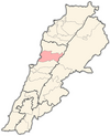
  Jeita Location in Lebanon | |
| Coordinates: 33°57′14″N 35°38′36″E / 33.95389°N 35.64333°E / 33.95389; 35.64333 | |
| Country |  Lebanon Lebanon |
| Governorate | Keserwan-Jbeil |
| District | Keserwan |
| Time zone | UTC+2 (EET) |
| • Summer (DST) | UTC+3 (EEST) |
Jeita (Arabic: جعيتا Jʿītā; also spelled Jaaita or Jaita) is a town and municipality located in the Keserwan District of the Keserwan-Jbeil Governorate of Lebanon. The town is about 20 kilometres (12 mi) north of Beirut.[1] It has an average elevation of 380 meters above sea level and a total land area of 290 hectares.[1] Jeita's inhabitants are Maronites.[2]
It is well known for the Jeita Grotto which is a popular tourist attraction, as well as the Nahr al-Kalb, a river that runs from a spring near the grotto emptying into the Mediterranean Sea. The name Jeita is derived from the Aramaic word Ge’itta, meaning "roar" or "noise".[3]
History
In 1838, Eli Smith noted Ja'ita as a village located in "Aklim el-Kesrawan, Northeast of Beirut; the chief seat of the Maronites".[4]
References
- ^ a b "Jaaita". Localiban. Localiban. 2008-01-21. Retrieved 2009-07-24.
- ^ "Elections municipales et ikhtiariah au Mont-Liban" (PDF). Localiban. Localiban. 2010. p. 19. Archived from the original (pdf) on 2015-07-24. Retrieved 2016-02-12.
- ^ Lebanese Maronite Villages or Towns Archived 2009-06-23 at the Wayback Machine. Retrieved on 2009-07-24.
- ^ Robinson and Smith, 1841, vol 3, 2nd appendix, p. 193
Bibliography
- Robinson, E.; Smith, E. (1841). Biblical Researches in Palestine, Mount Sinai and Arabia Petraea: A Journal of Travels in the year 1838. Vol. 3. Boston: Crocker & Brewster.
External links
- Jaaita, localiban
- v
- t
- e

Capital: Jounieh
- Adma wa Dafneh
- Ain el-Rihaneh
- Aintoura
- Ajaltoun
- Aramoun
- Ashqout
- Azra
- Ballouneh
- Batha
- Bkerké
- Bqaatouta
- Bzoummar
- Chahtoul-Jouret Mhad
- Chnaniir
- Daraoun
- Daraya
- Dlebta
- Faitroun
- Faraya
- Fatqa
- Ghazir
- Ghbaleh
- Ghidras
- Ghineh
- Ghosta
- Harissa-Daraoun
- Herharaya
- Hrajel
- Jdaidet Ghazir
- Jeita
- Jouret Bedran
- Jouret el-Termos
- Kaslik
- Kfar Dibiane
- Kfar Yassine
- Okaibe
- Qattine
- Qleiat
- Maarab
- Mayrouba
- Rayfoun
- Safra
- Sahel Alma
- Sarba
- Sehaileh
- Tabarja
- Yahchouch
- Zouk Mikael
- Zouk Mosbeh
 | This Lebanon location article is a stub. You can help Wikipedia by expanding it. |
- v
- t
- e


