Hòa Vang district
You can help expand this article with text translated from the corresponding article in Vietnamese. (March 2009) Click [show] for important translation instructions.
- View a machine-translated version of the Vietnamese article.
- Machine translation, like DeepL or Google Translate, is a useful starting point for translations, but translators must revise errors as necessary and confirm that the translation is accurate, rather than simply copy-pasting machine-translated text into the English Wikipedia.
- Do not translate text that appears unreliable or low-quality. If possible, verify the text with references provided in the foreign-language article.
- You must provide copyright attribution in the edit summary accompanying your translation by providing an interlanguage link to the source of your translation. A model attribution edit summary is
Content in this edit is translated from the existing Vietnamese Wikipedia article at [[:vi:Hòa Vang]]; see its history for attribution. - You may also add the template
{{Translated|vi|Hòa Vang}}to the talk page. - For more guidance, see Wikipedia:Translation.
District in South Central Coast, Vietnam
Hòa Vang district Huyện Hòa Vang | |
|---|---|
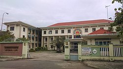 Hòa Vang District People's Committee | |
 Seal | |
 Administration map of the district in Da Nang | |
| Country |  Vietnam Vietnam |
| Region | South Central Coast |
| Municipality | Da Nang |
| Area | |
| • Total | 273 sq mi (708 km2) |
| Population (2018) | |
| • Total | 201,070 |
| Time zone | UTC+7 (Indochina Time) |
Hòa Vang is a rural district (huyện) of Da Nang in the South Central Coast region of Vietnam. It is bordered by Liên Chiểu and Cẩm Lệ districts to the east, Thừa Thiên-Huế province to the north and northwest, and Quảng Nam province to the west and south.

Administration
As of 2003 the district had a population of 106,746.[1] The district covers an area of 708 km².[1]
Hòa Vang district is subdivided into 11 rural communes (xã):
- Hòa Bắc
- Hòa Liên
- Hòa Ninh
- Hòa Sơn
- Hòa Nhơn
- Hòa Phong
- Hòa Phú
- Hòa Khương
- Hòa Châu
- Hòa Phước
- Hòa Tiến
The district capital lies at Hòa Phong commune.
References
- ^ a b "Districts of Vietnam". Statoids. Retrieved March 20, 2009.
16°04′59″N 108°00′00″E / 16.083°N 108.000°E / 16.083; 108.000
- v
- t
- e
Districts of the Vietnamese South Central Coast
- Urban districts
- Hòa Vang
- Hoàng Sa§

- Cam Ranh city
- Nha Trang city※
- Ninh Hòa town
- Cam Lâm
- Diên Khánh
- Khánh Sơn
- Khánh Vĩnh
- Trường Sa§
- Vạn Ninh
※ denotes provincial seat. / § Sovereignty over the Hoàng Sa and Trường Sa archipelagoes is disputed as of 22 September 2024.


 Hòa_Vang_District