Grade II* listed buildings in South Norfolk
Map all coordinates using OpenStreetMap
Download coordinates as:
- KML
- GPX (all coordinates)
- GPX (primary coordinates)
- GPX (secondary coordinates)
There are over 20,000 Grade II* listed buildings in England. This page is a list of these buildings in the district of South Norfolk in Norfolk.
South Norfolk
| Name | Location | Type | Completed [note 1] | Date designated | Grid ref.[note 2] Geo-coordinates | Entry number [note 3] | Image |
|---|---|---|---|---|---|---|---|
| Homersfield Bridge | Alburgh, South Norfolk | Bridge | 1869 | 3 June 1981 | TM2836785740 52°25′19″N 1°21′26″E / 52.421933°N 1.357144°E / 52.421933; 1.357144 (Homersfield Bridge) | 1031993 |  More images |
| Church of St Mary | Ashby St Mary | Parish Church | 12th century | 5 September 1960 | TG3292902234 52°34′05″N 1°26′08″E / 52.568025°N 1.435637°E / 52.568025; 1.435637 (Church of St Mary) | 1050660 |  More images |
| St Mary's Chapel | Ashwellthorpe, Ashwellthorpe and Fundenhall | House | 18th century | 11 September 1951 | TM1636997447 52°31′55″N 1°11′19″E / 52.53189°N 1.188588°E / 52.53189; 1.188588 (St Mary's Chapel) | 1373555 |  Upload Photo |
| Church of St Botolph | Barford | Parish Church | 13th century | 26 November 1959 | TG1069707988 52°37′43″N 1°06′42″E / 52.628734°N 1.111798°E / 52.628734; 1.111798 (Church of St Botolph) | 1050737 |  More images |
| Church Farmhouse | Bawburgh | Farmhouse | Late Medieval | 14 April 1983 | TG1531608666 52°37′59″N 1°10′49″E / 52.633009°N 1.180376°E / 52.633009; 1.180376 (Church Farmhouse) | 1050779 | Upload Photo |
| Lodge Farmhouse | Bawburgh | House | Mid 19th century | 14 April 1983 | TG1676708868 52°38′03″N 1°12′07″E / 52.634245°N 1.201915°E / 52.634245; 1.201915 (Lodge Farmhouse) | 1373047 | Upload Photo |
| The Hermit's House | Bawburgh | House | 17th century | 2 October 1951 | TG1573208818 52°38′03″N 1°11′12″E / 52.634208°N 1.186613°E / 52.634208; 1.186613 (The Hermit's House) | 1050783 | Upload Photo |
| The Slipper Chapel in Garden of Brecon House | Bawburgh | Garden House | Mid 17th century | 2 October 1951 | TG1574408782 52°38′02″N 1°11′12″E / 52.63388°N 1.186766°E / 52.63388; 1.186766 (The Slipper Chapel in Garden of Brecon House) | 1373019 | Upload Photo |
| Church of St Peter and St Paul | Bergh Apton | Parish Church | 14th century | 5 September 1960 | TM3105299895 52°32′52″N 1°24′23″E / 52.547835°N 1.406366°E / 52.547835; 1.406366 (Church of St Peter and St Paul) | 1373078 |  More images |
| Church of St Wandregesilius | Bixley | Church | 1771 | 26 November 1959 | TG2585904964 52°35′44″N 1°20′00″E / 52.595504°N 1.333367°E / 52.595504; 1.333367 (Church of St Wandregesilius) | 1050487 |  More images |
| Barn and Attached Outbuildings at Church Farm | Hethel, Bracon Ash | Barn | Mid/Late 18th century | 15 November 1999 | TG1684900315 52°33′27″N 1°11′51″E / 52.557442°N 1.197525°E / 52.557442; 1.197525 (Barn and Attached Outbuildings at Church Farm) | 1379809 | Upload Photo |
| Cart Shed at Church Farm | Hethel, Bracon Ash | Cart Shed | 18th century | 15 November 1999 | TG1686000344 52°33′28″N 1°11′52″E / 52.557698°N 1.197706°E / 52.557698; 1.197706 (Cart Shed at Church Farm) | 1379810 | Upload Photo |
| Church Farm House | Hethel, Bracon Ash | Farmhouse | 17th century | 15 November 1999 | TG1682600292 52°33′26″N 1°11′50″E / 52.557245°N 1.197171°E / 52.557245; 1.197171 (Church Farm House) | 1379811 | Upload Photo |
| Mergate Hall | Bracon Ash | House | 17th century | 2 October 1951 | TM1825799394 52°32′55″N 1°13′04″E / 52.548613°N 1.217655°E / 52.548613; 1.217655 (Mergate Hall) | 1050692 | Upload Photo |
| Church of St Peter | Bramerton | Parish Church | c. 1300 | 26 November 1959 | TG2959704686 52°35′29″N 1°23′18″E / 52.591445°N 1.388262°E / 52.591445; 1.388262 (Church of St Peter) | 1050489 |  More images |
| Grange Farmhouse | Bressingham | House | 16th century | 11 September 1951 | TM0848081400 52°23′27″N 1°03′45″E / 52.390909°N 1.062442°E / 52.390909; 1.062442 (Grange Farmhouse) | 1373591 | Upload Photo |
| Valley Farmhouse | Bressingham | House | 16th century | 11 September 1951 | TM0727581595 52°23′35″N 1°02′42″E / 52.393116°N 1.044881°E / 52.393116; 1.044881 (Valley Farmhouse) | 1049665 | Upload Photo |
| Brockdish Hall | Brockdish | House | Early 17th century | 11 September 1951 | TM2117580412 52°22′37″N 1°14′53″E / 52.377064°N 1.248043°E / 52.377064; 1.248043 (Brockdish Hall) | 1305933 | Upload Photo |
| The Grange | Brockdish | House | 1676 | 19 September 1957 | TM2024480020 52°22′26″N 1°14′03″E / 52.373921°N 1.234131°E / 52.373921; 1.234131 (The Grange) | 1049632 | Upload Photo |
| Church of St Peter | Brooke | Parish Church | Medieval | 5 September 1960 | TM2939799541 52°32′43″N 1°22′54″E / 52.545357°N 1.381758°E / 52.545357; 1.381758 (Church of St Peter) | 1051120 | 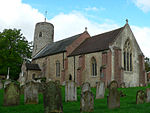 More images |
| Porch House | Brooke | House | 17th century | 25 September 1951 | TM2917999275 52°32′35″N 1°22′42″E / 52.543062°N 1.378365°E / 52.543062; 1.378365 (Porch House) | 1372848 | Upload Photo |
| Alma House including Boundary Walls to North and South | Broome | Farmhouse | Early 18th century | 25 September 1951 | TM3431790840 52°27′55″N 1°26′53″E / 52.465185°N 1.448055°E / 52.465185; 1.448055 (Alma House including Boundary Walls to North and South) | 1152917 | Upload Photo |
| Church of St Mary | Burgh St Peter | Parish Church | 14th century | 5 September 1960 | TM4935193706 52°29′03″N 1°40′16″E / 52.484245°N 1.671041°E / 52.484245; 1.671041 (Church of St Mary) | 1304545 |  More images |
| Church of St Mary | Burston | Tower | 1753 | 7 December 1959 | TM1370383187 52°24′18″N 1°08′25″E / 52.404938°N 1.140216°E / 52.404938; 1.140216 (Church of St Mary) | 1305672 |  More images |
| Shimpling Place | Shimpling | House | 16th century | 11 September 1951 | TM1516283523 52°24′27″N 1°09′43″E / 52.407383°N 1.161845°E / 52.407383; 1.161845 (Shimpling Place) | 1049620 | Upload Photo |
| Church of St Edmund | Caistor St Edmund | Parish Church | Early 14th century | 26 November 1959 | TG2322103380 52°34′57″N 1°17′36″E / 52.582377°N 1.293421°E / 52.582377; 1.293421 (Church of St Edmund) | 1373145 |  More images |
| The Old Hall | Caistor St Edmund | House | 1612 | 2 October 1951 | TG2329803807 52°35′10″N 1°17′41″E / 52.586177°N 1.294843°E / 52.586177; 1.294843 (The Old Hall) | 1050563 | Upload Photo |
| Church of St Peter | Carleton St Peter | Parish Church | 13th century | 5 September 1960 | TG3396702287 52°34′05″N 1°27′03″E / 52.568056°N 1.45096°E / 52.568056; 1.45096 (Church of St Peter) | 1050629 |  More images |
| Remains of Claxton Castle | Claxton | Fortified House | Post 1333 | 25 September 1951 | TG3354303778 52°34′54″N 1°26′45″E / 52.581617°N 1.445766°E / 52.581617; 1.445766 (Remains of Claxton Castle) | 1050630 | 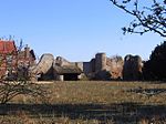 More images |
| Church of St. Andrew | Colney | Church | 14th century | 20 April 1959 | TG1807407956 52°37′32″N 1°13′14″E / 52.625536°N 1.220595°E / 52.625536; 1.220595 (Church of St. Andrew) | 1050754 | 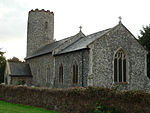 More images |
| Church of St Peter | Cringleford | Church | 1940 | 26 November 1959 | TG1983605824 52°36′20″N 1°14′43″E / 52.60569°N 1.245166°E / 52.60569; 1.245166 (Church of St Peter) | 1306659 | 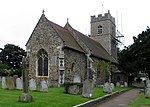 More images |
| Lodge Farmhouse | Denton | Aisled House | Circa 14th century | 26 June 1981 | TM2890988611 52°26′51″N 1°22′01″E / 52.447472°N 1.367065°E / 52.447472; 1.367065 (Lodge Farmhouse) | 1373629 | Upload Photo |
| Church of St Mary | Hackford, Deopham | Parish Church | 12th century | 26 November 1959 | TG0594302258 52°34′45″N 1°02′17″E / 52.579118°N 1.038098°E / 52.579118; 1.038098 (Church of St Mary) | 1172492 |  More images |
| Crown Farmhouse | Deopham | Farmhouse | 16th century | 15 August 1983 | TG0434300801 52°34′00″N 1°00′49″E / 52.566641°N 1.013622°E / 52.566641; 1.013622 (Crown Farmhouse) | 1172516 | Upload Photo |
| Manor House | Dickleburgh and Rushall | House | 18th century | 11 September 1951 | TM1657681889 52°23′32″N 1°10′54″E / 52.392158°N 1.181543°E / 52.392158; 1.181543 (Manor House) | 1304866 | Upload Photo |
| Dolphin House | Diss | Timber Framed House | Early 16th century | 29 December 1950 | TM1172979974 52°22′37″N 1°06′33″E / 52.376862°N 1.109214°E / 52.376862; 1.109214 (Dolphin House) | 1373524 |  More images |
| 2 Mount Street | Diss | House | Early 19th century | 8 June 1972 | TM1169080061 52°22′40″N 1°06′31″E / 52.377658°N 1.108697°E / 52.377658; 1.108697 (2 Mount Street) | 1049711 |  |
| Earsham Hall | Earsham | House | 17th century | 11 September 1951 | TM3080389821 52°27′27″N 1°23′45″E / 52.457535°N 1.395719°E / 52.457535; 1.395719 (Earsham Hall) | 1050397 | 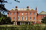 More images |
| Church of St Mary | East Carleton | Parish Church | Medieval | 26 November 1959 | TG1798002060 52°34′22″N 1°12′55″E / 52.572653°N 1.215327°E / 52.572653; 1.215327 (Church of St Mary) | 1306618 | 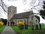 More images |
| West Lodge | Lower Easton, Easton | Farmhouse | c. 1600 | 14 April 1983 | TG1409411710 52°39′39″N 1°09′52″E / 52.660814°N 1.164322°E / 52.660814; 1.164322 (West Lodge) | 1050771 | Upload Photo |
| Church of St Michael | Flordon | Parish Church | 11th century or 12th century | 26 November 1959 | TM1892497267 52°31′45″N 1°13′34″E / 52.529255°N 1.226075°E / 52.529255; 1.226075 (Church of St Michael) | 1172235 |  More images |
| Flordon Hall | Flordon | Farmhouse | 1595-1612 | 2 October 1951 | TM1867497982 52°32′09″N 1°13′22″E / 52.535773°N 1.222866°E / 52.535773; 1.222866 (Flordon Hall) | 1050698 |  More images |
| Old Hall Farmhouse | Forncett St Mary, Forncett | House | Late 16th century | 26 June 1981 | TM1664494238 52°30′11″N 1°11′26″E / 52.502977°N 1.190547°E / 52.502977; 1.190547 (Old Hall Farmhouse) | 1373219 | Upload Photo |
| Yew Tree Farmhouse | Forncett St Mary, Forncett | Timber Framed House | 15th century | 26 June 1981 | TM1674094611 52°30′23″N 1°11′32″E / 52.506287°N 1.192202°E / 52.506287; 1.192202 (Yew Tree Farmhouse) | 1152706 | Upload Photo |
| Church of St Andrew | Framingham Pigot | Parish Church | 1859 | 7 September 1988 | TG2779503600 52°34′57″N 1°21′39″E / 52.582456°N 1.360962°E / 52.582456; 1.360962 (Church of St Andrew) | 1050456 | 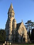 More images |
| Church of St. Michael and All Angels | Geldeston | Parish Church | 12th century | 5 September 1960 | TM3947492284 52°28′33″N 1°31′29″E / 52.475906°N 1.524856°E / 52.475906; 1.524856 (Church of St. Michael and All Angels) | 1153255 |  More images |
| Gillingham Hall | Gillingham | Country House | c. 1600 | 25 September 1951 | TM4131492276 52°28′30″N 1°33′07″E / 52.475025°N 1.551888°E / 52.475025; 1.551888 (Gillingham Hall) | 1050581 |  More images |
| Church of All Saints | Great Melton | Church | 11th century | 26 November 1959 | TG1406406148 52°36′39″N 1°09′37″E / 52.610902°N 1.160276°E / 52.610902; 1.160276 (Church of All Saints) | 1050731 | 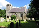 More images |
| Remains of Church of St Mary | Great Melton | Tower | 15th century | 26 November 1959 | TG1404106123 52°36′38″N 1°09′36″E / 52.610686°N 1.159921°E / 52.610686; 1.159921 (Remains of Church of St Mary) | 1050732 |  More images |
| Church of St Michael | Great Moulton | Tower | 1887 | 7 December 1959 | TM1658490786 52°28′19″N 1°11′15″E / 52.472016°N 1.187422°E / 52.472016; 1.187422 (Church of St Michael) | 1050319 |  More images |
| Old Rectory | Moulton St Michael, Great Moulton | Tower | 1831 | 15 September 1977 | TM1659690724 52°28′17″N 1°11′15″E / 52.471455°N 1.187558°E / 52.471455; 1.187558 (Old Rectory) | 1050320 | Upload Photo |
| Tomb Chest About 20 Metres South South West of Church of St Michael | Great Moulton | Chest Tomb | 15th century | 19 August 1993 | TM1656290756 52°28′18″N 1°11′13″E / 52.471755°N 1.187079°E / 52.471755; 1.187079 (Tomb Chest About 20 Metres South South West of Church of St Michael) | 1335082 | Upload Photo |
| Church of St Remigius | Hethersett | Parish Church | 14th century | 26 November 1959 | TG1608204918 52°35′57″N 1°11′21″E / 52.599063°N 1.189229°E / 52.599063; 1.189229 (Church of St Remigius) | 1373115 | 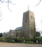 More images |
| Admiral's House | Hingham | House | Early 18th century | 26 November 1959 | TG0238602153 52°34′46″N 0°59′08″E / 52.579509°N 0.985614°E / 52.579509; 0.985614 (Admiral's House) | 1305575 | Upload Photo |
| Beaconsfield House Including Railings and Gateway in Front. | Hingham | House | Early 18th century | 26 November 1959 | TG0238802142 52°34′46″N 0°59′08″E / 52.57941°N 0.985637°E / 52.57941; 0.985637 (Beaconsfield House Including Railings and Gateway in Front.) | 1051143 | More images |
| Little London | Hingham | House | 18th century | 26 November 1959 | TG0238002180 52°34′47″N 0°59′08″E / 52.579754°N 0.985542°E / 52.579754; 0.985542 (Little London) | 1051142 |  More images |
| Quorn House | Hingham | House | Late 18th century | 26 November 1959 | TG0237602196 52°34′48″N 0°59′08″E / 52.579899°N 0.985493°E / 52.579899; 0.985493 (Quorn House) | 1171512 |  More images |
| Southernwood House | Hingham | House | C17/18 | 2 October 1951 | TG0236302221 52°34′48″N 0°59′07″E / 52.580128°N 0.985317°E / 52.580128; 0.985317 (Southernwood House) | 1051141 | Upload Photo |
| The Mansion House | Hingham | House | Late 17th century | 26 November 1959 | TG0221402267 52°34′50″N 0°58′59″E / 52.580597°N 0.983149°E / 52.580597; 0.983149 (The Mansion House) | 1171125 | Upload Photo |
| Holverston Hall | Holverston | House | 16th century | 7 September 1988 | TG3072703191 52°34′39″N 1°24′14″E / 52.577551°N 1.403873°E / 52.577551; 1.403873 (Holverston Hall) | 1050458 | Upload Photo |
| Church of St Mary | Howe | Parish Church | Medieval | 5 September 1960 | TM2750299957 52°33′00″N 1°21′15″E / 52.549885°N 1.354147°E / 52.549885; 1.354147 (Church of St Mary) | 1372850 | 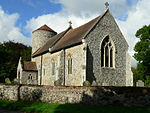 More images |
| Church of All Saints | Intwood, Keswick and Intwood | Parish Church | 12th century | 26 November 1959 | TG1968704184 52°35′28″N 1°14′31″E / 52.591031°N 1.241882°E / 52.591031; 1.241882 (Church of All Saints) | 1373136 | 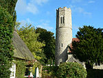 More images |
| Church of St Peter | Ketteringham | Parish Church | 11th century | 26 November 1959 | TG1638102561 52°34′40″N 1°11′32″E / 52.577788°N 1.192098°E / 52.577788; 1.192098 (Church of St Peter) | 1373140 |  More images |
| Left Gateway Turret to Stable Yard at Ketteringham Hall incorporating a Greek Marble, with Attached Range | Ketteringham | Gate | 1899 | 26 October 1987 | TG1645202544 52°34′39″N 1°11′35″E / 52.577607°N 1.193133°E / 52.577607; 1.193133 (Left Gateway Turret to Stable Yard at Ketteringham Hall incorporating a Greek Marble, with Attached Range) | 1373142 | 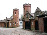 |
| Right Gateway Turret to Stable Yard at Ketteringham Hall and Attached Range, incorporating Three Greek Marbles | Ketteringham | Gate | 1899 | 26 October 1987 | TG1642602564 52°34′40″N 1°11′34″E / 52.577797°N 1.192763°E / 52.577797; 1.192763 (Right Gateway Turret to Stable Yard at Ketteringham Hall and Attached Range, incorporating Three Greek Marbles) | 1170116 |  |
| Stanfield Hall (that part in Ketteringham Parish) | Ketteringham | House | 1792 | 14 July 1972 | TG1434001004 52°33′53″N 1°09′40″E / 52.56462°N 1.161019°E / 52.56462; 1.161019 (Stanfield Hall (that part in Ketteringham Parish)) | 1050548 | Upload Photo |
| Church of St Mary | Carleton Forehoe, Kimberley | Parish Church | 15th century | 26 November 1959 | TG0896205845 52°36′37″N 1°05′05″E / 52.610167°N 1.084849°E / 52.610167; 1.084849 (Church of St Mary) | 1172547 |  More images |
| Church of St Peter | Kimberley | Parish Church | 12th century | 26 November 1959 | TG0715204172 52°35′45″N 1°03′26″E / 52.595841°N 1.057111°E / 52.595841; 1.057111 (Church of St Peter) | 1050747 |  More images |
| Church of St Andrew | Kirby Bedon | Parish Church | 14th century | 26 November 1959 | TG2785505440 52°35′56″N 1°21′47″E / 52.598944°N 1.363111°E / 52.598944; 1.363111 (Church of St Andrew) | 1169464 | 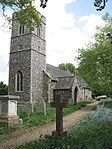 More images |
| Remains of Church of St Mary | Kirby Bedon | Church ruin | 13th century | 26 November 1959 | TG2792705414 52°35′55″N 1°21′51″E / 52.59868°N 1.364154°E / 52.59868; 1.364154 (Remains of Church of St Mary) | 1050460 |  More images |
| Kirby Cane Hall | Kirby Cane | Country House | 17th century | 25 September 1951 | TM3729294105 52°29′36″N 1°29′39″E / 52.493199°N 1.494087°E / 52.493199; 1.494087 (Kirby Cane Hall) | 1050591 |  More images |
| Church of St Margaret | Kirstead | Parish Church | c. 1200 | 5 September 1960 | TM2962298492 52°32′09″N 1°23′04″E / 52.535848°N 1.384345°E / 52.535848; 1.384345 (Church of St Margaret) | 1372852 |  More images |
| Former Stable Block to Langley Abbey | Langley Green, Langley with Hardley | Abbey | 16th century | 25 September 1951 | TG3622002837 52°34′19″N 1°29′04″E / 52.572018°N 1.484531°E / 52.572018; 1.484531 (Former Stable Block to Langley Abbey) | 1306556 | Upload Photo |
| Hardley Hall | Langley with Hardley | Country House | Mid/Late 16th century | 25 September 1951 | TG3873000031 52°32′45″N 1°31′10″E / 52.545745°N 1.519478°E / 52.545745; 1.519478 (Hardley Hall) | 1050632 |  More images |
| Church of St Mary and All Saints | Little Melton | Parish Church | Early 14th century | 26 November 1959 | TG1534106912 52°37′02″N 1°10′47″E / 52.617255°N 1.179603°E / 52.617255; 1.179603 (Church of St Mary and All Saints) | 1050541 |  More images |
| Loddon House | Loddon | House | c. 1710 | 25 September 1951 | TM3628998416 52°31′56″N 1°28′57″E / 52.532318°N 1.482401°E / 52.532318; 1.482401 (Loddon House) | 1050533 |  More images |
| Small Barn immediately South East of Hales Hall | Hales Green, Loddon | Barn | 17th century | 4 February 1977 | TM3698296055 52°30′39″N 1°29′27″E / 52.510831°N 1.490917°E / 52.510831; 1.490917 (Small Barn immediately South East of Hales Hall) | 1050506 | Upload Photo |
| Wall immediately South East of Hales Hall | Hales Green, Loddon | Gate | Late 15th century | 4 February 1977 | TM3696896033 52°30′38″N 1°29′27″E / 52.51064°N 1.490695°E / 52.51064; 1.490695 (Wall immediately South East of Hales Hall) | 1169573 | Upload Photo |
| Premises Owned by Mr Tummore and G.J. Cracknell and Son | Long Stratton | House | 17th century | 7 December 1959 | TM1969192636 52°29′15″N 1°14′04″E / 52.48738°N 1.234307°E / 52.48738; 1.234307 (Premises Owned by Mr Tummore and G.J. Cracknell and Son) | 1050276 | Upload Photo |
| The Old Rectory | Stratton St Michael, Long Stratton | House | 16th century | 7 December 1959 | TM2052093581 52°29′44″N 1°14′50″E / 52.495528°N 1.247121°E / 52.495528; 1.247121 (The Old Rectory) | 1373264 | Upload Photo |
| Church of St Andrew | Colton, Marlingford and Colton | Parish Church | 14th century | 15 August 1983 | TG1044409327 52°38′27″N 1°06′32″E / 52.640851°N 1.108919°E / 52.640851; 1.108919 (Church of St Andrew) | 1050751 |  More images |
| Church of St Mary | Marlingford and Colton | Parish Church | 12th century | 29 November 1959 | TG1271608320 52°37′51″N 1°08′30″E / 52.630927°N 1.141796°E / 52.630927; 1.141796 (Church of St Mary) | 1373046 |  More images |
| The Old Hall | Marlingford and Colton | Farmhouse | 1608 | 2 October 1951 | TG1326309178 52°38′18″N 1°09′02″E / 52.638414°N 1.150419°E / 52.638414; 1.150419 (The Old Hall) | 1151936 | Upload Photo |
| Church of St Botolph | Morley St Botolph, Morley | Parish Church | 15th century | 15 August 1983 | TG0693200214 52°33′37″N 1°03′05″E / 52.560394°N 1.051398°E / 52.560394; 1.051398 (Church of St Botolph) | 1373064 |  More images |
| Church of St Peter | Morley | Parish Church | 15th century | 29 November 1959 | TM0633998645 52°32′48″N 1°02′30″E / 52.546533°N 1.041688°E / 52.546533; 1.041688 (Church of St Peter) | 1304931 | 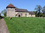 More images |
| Morley Manor | Morley | Manor House | Early 17th century | 2 October 1951 | TM0544699429 52°33′14″N 1°01′44″E / 52.553909°N 1.029023°E / 52.553909; 1.029023 (Morley Manor) | 1373065 | Upload Photo |
| Church of St Mary Magdalen | Mulbarton | Parish Church | Medieval | 26 November 1959 | TG1942501147 52°33′50″N 1°14′10″E / 52.563878°N 1.236011°E / 52.563878; 1.236011 (Church of St Mary Magdalen) | 1172267 |  More images |
| Church of St Mary the Virgin | Newton Flotman | Parish Church | 15th century | 26 November 1959 | TM2129898475 52°32′21″N 1°15′43″E / 52.539139°N 1.261817°E / 52.539139; 1.261817 (Church of St Mary the Virgin) | 1050704 |  More images |
| Dairy Farmhouse Barn | Newton Flotman | Barn | c. 1500 | 2 December 1983 | TM2192999186 52°32′43″N 1°16′18″E / 52.545263°N 1.27158°E / 52.545263; 1.27158 (Dairy Farmhouse Barn) | 1050707 | Upload Photo |
| Church Farmhouse | Poringland | Farmhouse | c. 1600 | 26 November 1959 | TG2714001644 52°33′55″N 1°21′00″E / 52.565176°N 1.349972°E / 52.565176; 1.349972 (Church Farmhouse) | 1306467 | Upload Photo |
| Porch House | Poringland | Farmhouse | Late 16th century | 26 November 1959 | TG2717101744 52°33′58″N 1°21′02″E / 52.56606°N 1.350497°E / 52.56606; 1.350497 (Porch House) | 1373181 | Upload Photo |
| Manor Farmhouse | Pulham Market | Farmhouse | Late 16th century | 11 September 1951 | TM2110988467 52°26′58″N 1°15′09″E / 52.449389°N 1.252394°E / 52.449389; 1.252394 (Manor Farmhouse) | 1373298 |  More images |
| Church of St Andrew | Raveningham | Parish Church | 12th century | 5 September 1960 | TM3978896399 52°30′46″N 1°31′57″E / 52.512692°N 1.532431°E / 52.512692; 1.532431 (Church of St Andrew) | 1050483 | 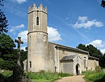 More images |
| Raveningham Hall | Raveningham Park, Raveningham | Country House | Late 18th century | 25 September 1951 | TM3991096467 52°30′48″N 1°32′03″E / 52.513248°N 1.534274°E / 52.513248; 1.534274 (Raveningham Hall) | 1306263 |  More images |
| Candler's House | Harleston, Redenhall with Harleston | House | Early 18th century | 7 December 1959 | TM2471883605 52°24′15″N 1°18′08″E / 52.404281°N 1.302143°E / 52.404281; 1.302143 (Candler's House) | 1156043 | Upload Photo |
| Swan Hotel | Harleston, Redenhall with Harleston | House | 17th century | 11 September 1951 | TM2453983416 52°24′10″N 1°17′58″E / 52.402658°N 1.29939°E / 52.402658; 1.29939 (Swan Hotel) | 1050109 | Upload Photo |
| 16 & 18, Old Market Place, Harleston | Harleston, Redenhall with Harleston | House | C14/15 | 26 November 1976 | TM2461283322 52°24′06″N 1°18′01″E / 52.401785°N 1.300398°E / 52.401785; 1.300398 (16 & 18, Old Market Place, Harleston) | 1303092 | Upload Photo |
| Church of St Mary | Rockland St Mary | Parish Church | 14th century | 26 November 1959 | TG3119303983 52°35′04″N 1°24′41″E / 52.58446°N 1.411289°E / 52.58446; 1.411289 (Church of St Mary) | 1169589 | 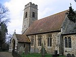 More images |
| Church of All Saints | Runhall | Parish Church | 12th century | 15 August 1983 | TG0579606917 52°37′16″N 1°02′20″E / 52.620998°N 1.038827°E / 52.620998; 1.038827 (Church of All Saints) | 1152154 | 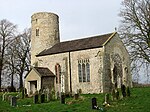 More images |
| Church of All Saints | Welborne, Runhall | Parish Church | 12th century | 15 August 1983 | TG0676310176 52°39′00″N 1°03′18″E / 52.649887°N 1.05513°E / 52.649887; 1.05513 (Church of All Saints) | 1304940 |  More images |
| Church of All Saints | Brandon Parva, Runhall | Parish Church | 15th century | 15 August 1983 | TG0702608077 52°37′51″N 1°03′28″E / 52.630944°N 1.057697°E / 52.630944; 1.057697 (Church of All Saints) | 1373067 |  More images |
| Church of St Michael | Coston, Runhall | Parish Church | 13th century | 15 August 1983 | TG0622706210 52°36′52″N 1°02′41″E / 52.614488°N 1.044744°E / 52.614488; 1.044744 (Church of St Michael) | 1373066 |  More images |
| Church of St Mary the Virgin | Saxlingham Nethergate | Parish Church | 11th century or 12th century | 26 November 1959 | TM2313797204 52°31′37″N 1°17′17″E / 52.526982°N 1.288033°E / 52.526982; 1.288033 (Church of St Mary the Virgin) | 1050666 |  More images |
| Old Hall | Saxlingham Nethergate | Manor House | 1st half of 17th century | 2 October 1951 | TM2323597154 52°31′35″N 1°17′22″E / 52.526493°N 1.289442°E / 52.526493; 1.289442 (Old Hall) | 1050665 | Upload Photo |
| Remains of Church of St Mary | Saxlingham Nethergate | Church ruin | Before 1700 | 26 November 1959 | TM2307696603 52°31′18″N 1°17′12″E / 52.521612°N 1.286732°E / 52.521612; 1.286732 (Remains of Church of St Mary) | 1152354 |  More images |
| The Old Rectory | Saxlingham Nethergate | Vicarage | 1784 | 2 October 1951 | TM2310997170 52°31′36″N 1°17′15″E / 52.526688°N 1.287598°E / 52.526688; 1.287598 (The Old Rectory) | 1050667 | Upload Photo |
| Billingford Windmill | Billingford, Scole | Windmill | Pre 1860 | 11 September 1951 | TM1669778567 52°21′44″N 1°10′52″E / 52.362291°N 1.181173°E / 52.362291; 1.181173 (Billingford Windmill) | 1303800 | 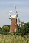 More images |
| Church of St Andrew | Scole | Church | Pre Conquest | 7 December 1959 | TM1510279045 52°22′02″N 1°09′29″E / 52.36721°N 1.158092°E / 52.36721; 1.158092 (Church of St Andrew) | 1156145 | 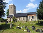 More images |
| Church of St Andrew | Thelveton, Scole | Church | 15th century | 7 December 1959 | TM1522881246 52°23′13″N 1°09′41″E / 52.386918°N 1.161352°E / 52.386918; 1.161352 (Church of St Andrew) | 1050120 | 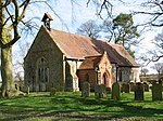 More images |
| Thelveton Hall | Thelveton, Scole | House | c. 1592 | 11 September 1951 | TM1555580855 52°23′00″N 1°09′57″E / 52.383279°N 1.165898°E / 52.383279; 1.165898 (Thelveton Hall) | 1156238 | Upload Photo |
| Church of St Margaret | Seething | Parish Church | Medieval | 5 September 1960 | TM3197497947 52°31′48″N 1°25′07″E / 52.529962°N 1.418578°E / 52.529962; 1.418578 (Church of St Margaret) | 1305988 |  More images |
| Church of All Saints | Shotesham | Parish Church | 11th century or 12th century | 26 November 1959 | TM2466899016 52°32′33″N 1°18′42″E / 52.542615°N 1.311787°E / 52.542615; 1.311787 (Church of All Saints) | 1050644 |  More images |
| Church of St Mary | Shotesham St Mary, Shotesham | Parish Church | Medieval | 26 November 1959 | TM2378198826 52°32′29″N 1°17′55″E / 52.541275°N 1.298602°E / 52.541275; 1.298602 (Church of St Mary) | 1050642 |  More images |
| Grove Farmhouse, Formerly Creasey's Grove Farmhouse | Shotesham | Farmhouse | 16th century | 2 October 1951 | TM2527698764 52°32′24″N 1°19′14″E / 52.540103°N 1.320566°E / 52.540103; 1.320566 (Grove Farmhouse, Formerly Creasey's Grove Farmhouse) | 1050646 | Upload Photo |
| The Duke's Head | Shotesham | Timber Framed House | 1712 | 26 November 1959 | TM2465099136 52°32′37″N 1°18′42″E / 52.5437°N 1.311603°E / 52.5437; 1.311603 (The Duke's Head) | 1050649 | Upload Photo |
| Church of St Mary | Sisland | Parish Church | Medieval | 5 September 1960 | TM3441198573 52°32′04″N 1°27′18″E / 52.534537°N 1.454878°E / 52.534537; 1.454878 (Church of St Mary) | 1051106 |  More images |
| Church of St Remigius | Dunston | Parish Church | 13th century | 26 November 1959 | TG2285402239 52°34′20″N 1°17′14″E / 52.572287°N 1.287247°E / 52.572287; 1.287247 (Church of St Remigius) | 1050433 |  More images |
| Church of the Holy Cross | Stoke Holy Cross | Parish Church | 13th century | 26 November 1959 | TG2358300792 52°33′32″N 1°17′49″E / 52.559001°N 1.29701°E / 52.559001; 1.29701 (Church of the Holy Cross) | 1050437 |  More images |
| Church of St Mary | Surlingham | Parish Church | Early 13th century | 26 November 1959 | TG3058406514 52°36′27″N 1°24′15″E / 52.607431°N 1.404079°E / 52.607431; 1.404079 (Church of St Mary) | 1050438 |  More images |
| Church of St Peter | Swainsthorpe | Parish Church | 12th century | 26 November 1959 | TG2186300970 52°33′41″N 1°16′18″E / 52.561302°N 1.2718°E / 52.561302; 1.2718 (Church of St Peter) | 1169726 | 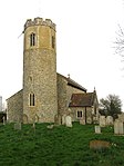 More images |
| Barn c.40m West of Gowthorpe Manor House | Gowthorpe, Swardeston | Barn | Early 17th century | 2 October 1951 | TG2078502345 52°34′27″N 1°15′25″E / 52.574081°N 1.256839°E / 52.574081; 1.256839 (Barn c.40m West of Gowthorpe Manor House) | 1366141 | Upload Photo |
| Church of St Mary | Swardeston | Parish Church | 11th century | 2 October 1951 | TG1990102397 52°34′30″N 1°14′38″E / 52.574906°N 1.24385°E / 52.574906; 1.24385 (Church of St Mary) | 1050556 |  More images |
| Gowthorpe Manor House | Gowthorpe, Swardeston | House | 16th century | 2 October 1951 | TG2084802321 52°34′26″N 1°15′28″E / 52.57384°N 1.257751°E / 52.57384; 1.257751 (Gowthorpe Manor House) | 1050515 | Upload Photo |
| Mangreen Hall | Mangreen, Swardeston | House | 17th century | 2 October 1951 | TG2155703044 52°34′48″N 1°16′07″E / 52.580041°N 1.268679°E / 52.580041; 1.268679 (Mangreen Hall) | 1366150 |  More images |
| Old Hall | Tacolneston | House | C16/17 | 11 September 1951 | TM1495295466 52°30′53″N 1°09′59″E / 52.514669°N 1.166452°E / 52.514669; 1.166452 (Old Hall) | 1373381 | Upload Photo |
| Tacolneston Hall | Tacolneston | House | 16th century | 11 September 1951 | TM1381695515 52°30′56″N 1°08′59″E / 52.515555°N 1.149769°E / 52.515555; 1.149769 (Tacolneston Hall) | 1050036 |  More images |
| The Manor Farmhouse | Tacolneston | House | Late 16th century | 11 September 1951 | TM1449095295 52°30′48″N 1°09′34″E / 52.513316°N 1.159544°E / 52.513316; 1.159544 (The Manor Farmhouse) | 1050043 | Upload Photo |
| Tharston Hall | Tharston and Hapton | House | Late 16th century | 11 September 1951 | TM1914994017 52°30′00″N 1°13′38″E / 52.499994°N 1.227246°E / 52.499994; 1.227246 (Tharston Hall) | 1373408 | 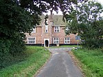 More images |
| Thurton Lodge on North West Side of Drive to Langley Park | Thurton | Gate Lodge | c. 1785 | 5 September 1960 | TM3437099896 52°32′47″N 1°27′19″E / 52.546427°N 1.455208°E / 52.546427; 1.455208 (Thurton Lodge on North West Side of Drive to Langley Park) | 1050638 | Upload Photo |
| Thurton Lodge, on South East Side of Drive to Langley Park | Thurton | Gate Lodge | c. 1785 | 5 September 1960 | TM3437899890 52°32′47″N 1°27′19″E / 52.546369°N 1.455321°E / 52.546369; 1.455321 (Thurton Lodge, on South East Side of Drive to Langley Park) | 1306478 | Upload Photo |
| Church of St Mary | Thwaite St Mary | Parish Church | 12th century | 5 September 1960 | TM3336395048 52°30′12″N 1°26′13″E / 52.503354°N 1.436984°E / 52.503354; 1.436984 (Church of St Mary) | 1372881 | 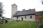 More images |
| Channonz Hall | Tibenham | Courtyard House | Second half of 16th century | 11 September 1951 | TM1477088471 52°27′07″N 1°09′33″E / 52.451952°N 1.159269°E / 52.451952; 1.159269 (Channonz Hall) | 1179541 | Upload Photo |
| Remains of Church of St Mary | Tivetshall St Mary | Tower | c. 1300 | 7 December 1959 | TM1662485810 52°25′38″N 1°11′05″E / 52.427335°N 1.184783°E / 52.427335; 1.184783 (Remains of Church of St Mary) | 1372995 | 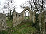 More images |
| The Elms | Toft Monks | Farmhouse | Early 17th century | 25 September 1951 | TM4332293992 52°29′22″N 1°34′58″E / 52.489531°N 1.582645°E / 52.489531; 1.582645 (The Elms) | 1373124 | Upload Photo |
| Church of St Margaret | Topcroft | Parish Church | Post Medieval | 5 September 1960 | TM2658592893 52°29′13″N 1°20′09″E / 52.48687°N 1.335837°E / 52.48687; 1.335837 (Church of St Margaret) | 1372884 |  More images |
| Whitlingham Hospital Blocks 04, 05, 06 | Trowse with Newton | Country House | c. 1865 | 31 October 1985 | TG2549906936 52°36′48″N 1°19′46″E / 52.613351°N 1.329405°E / 52.613351; 1.329405 (Whitlingham Hospital Blocks 04, 05, 06) | 1373212 |  More images |
| Wacton Hall | Wacton | House | 16th century | 11 September 1951 | TM1802990270 52°28′01″N 1°12′30″E / 52.46681°N 1.208324°E / 52.46681; 1.208324 (Wacton Hall) | 1050822 |  |
| Church of St James | Crownthorpe, Wicklewood | Church/House | Medieval | 15 August 1983 | TG0828803138 52°35′10″N 1°04′24″E / 52.586125°N 1.073207°E / 52.586125; 1.073207 (Church of St James) | 1152239 | 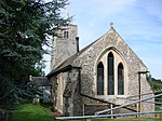 More images |
| The Old Hall | Wicklewood | Farmhouse | c. 1600 | 15 August 1983 | TG0793202899 52°35′03″N 1°04′04″E / 52.584116°N 1.067811°E / 52.584116; 1.067811 (The Old Hall) | 1373072 | Upload Photo |
| Wicklewood Hall | Wicklewood | Farmhouse | 17th century | 2 October 1951 | TG0865600715 52°33′51″N 1°04′38″E / 52.564233°N 1.077107°E / 52.564233; 1.077107 (Wicklewood Hall) | 1050726 | Upload Photo |
| Church of All Saints | Woodton | Parish Church | 12th century | 5 September 1960 | TM2854494621 52°30′06″N 1°21′57″E / 52.501562°N 1.365821°E / 52.501562; 1.365821 (Church of All Saints) | 1170855 |  More images |
| Oaks Farmhouse | Woodton | House | 17th century | 25 September 1960 | TM2771295683 52°30′41″N 1°21′16″E / 52.51144°N 1.354312°E / 52.51144; 1.354312 (Oaks Farmhouse) | 1170906 | Upload Photo |
| Homersfield Bridge | Wortwell | Bridge | 1869 | 3 June 1981 | TM2832985689 52°25′17″N 1°21′24″E / 52.421491°N 1.356551°E / 52.421491; 1.356551 (Homersfield Bridge) | 1262142 | More images |
| Quaker Farmhouse | Wramplingham | Farmhouse | 1643 | 29 November 1959 | TG1150306512 52°36′55″N 1°07′22″E / 52.615171°N 1.122744°E / 52.615171; 1.122744 (Quaker Farmhouse) | 1050729 | Upload Photo |
| High House Farmhouse | Wreningham | Farmhouse/House | c. 1640 | 20 April 1959 | TM1454199392 52°33′00″N 1°09′47″E / 52.550071°N 1.162938°E / 52.550071; 1.162938 (High House Farmhouse) | 1373111 |  More images |
| Poplars | Wreningham | Farmhouse | 1586 | 2 December 1983 | TM1558798418 52°32′27″N 1°10′40″E / 52.540916°N 1.177708°E / 52.540916; 1.177708 (Poplars) | 1152496 | Upload Photo |
| Green Dragon Public House | Wymondham | Hall House | 1950 | 29 December 1950 | TG1084201559 52°34′15″N 1°06′35″E / 52.570967°N 1.109844°E / 52.570967; 1.109844 (Green Dragon Public House) | 1196692 |  More images |
| Kimberley Hall including Service Wings to North West and South East | Wymondham | Country House | 1712 | 29 December 1950 | TG0904204748 52°36′01″N 1°05′07″E / 52.600288°N 1.085336°E / 52.600288; 1.085336 (Kimberley Hall including Service Wings to North West and South East) | 1293198 |  More images |
| Priory House, Middleton Street | Wymondham | House | c. 1670 | 29 December 1950 | TG1083901644 52°34′18″N 1°06′35″E / 52.571732°N 1.109854°E / 52.571732; 1.109854 (Priory House, Middleton Street) | 1297488 | Upload Photo |
| Stanfield Hall (that part in Wymondham Parish) | Stanfield, Wymondham | House | 1792 | 14 July 1972 | TG1433901002 52°33′53″N 1°09′40″E / 52.564602°N 1.161003°E / 52.564602; 1.161003 (Stanfield Hall (that part in Wymondham Parish)) | 1196723 | Upload Photo |
| The Chestnuts | Wymondham | House | 18th century | 26 January 1995 | TG1077001941 52°34′28″N 1°06′32″E / 52.574424°N 1.109026°E / 52.574424; 1.109026 (The Chestnuts) | 1243874 | Upload Photo |
| 3 Market Street | Wymondham | House | Later | 29 December 1950 | TG1091901551 52°34′15″N 1°06′40″E / 52.570866°N 1.110974°E / 52.570866; 1.110974 (3 Market Street) | 1196679 | Upload Photo |
Notes
- ^ The date given is the date used by Historic England as significant for the initial building or that of an important part in the structure's description.
- ^ Sometimes known as OSGB36, the grid reference is based on the British national grid reference system used by the Ordnance Survey.
- ^ The "List Entry Number" is a unique number assigned to each listed building and scheduled monument by Historic England.
External links
- v
- t
- e
- Bedfordshire
- Berkshire
- Bristol
- Buckinghamshire
- Cambridgeshire
- Cheshire
- Cornwall
- Cumbria
- Derbyshire
- Devon
- Dorset
- Durham
- East Sussex
- East Riding of Yorkshire
- Essex
- Gloucestershire
- Greater London
- Greater Manchester
- Hampshire
- Herefordshire
- Hertfordshire
- Isle of Wight
- Kent
- Lancashire
- Leicestershire
- Lincolnshire
- Merseyside
- Norfolk
- North Yorkshire
- Northamptonshire
- Northumberland
- Nottinghamshire
- Oxfordshire
- Rutland
- Shropshire
- Somerset
- South Yorkshire
- Staffordshire
- Suffolk
- Surrey
- Tyne and Wear
- Warwickshire
- West Midlands
- West Sussex
- West Yorkshire
- Wiltshire
- Worcestershire
- Allerdale
- Amber Valley
- Ashford
- Babergh
- Barrow-in-Furness
- Basildon
- Basingstoke and Deane
- Bath and North East Somerset
- Bolsover
- Boston
- Bournemouth
- Bradford
- Braintree
- Breckland
- Brentwood
- Brighton and Hove
- Bristol
- Broadland
- Calderdale
- Cambridge
- Camden
- Canterbury
- Carlisle
- Castle Point
- Chelmsford
- Cheltenham
- Cherwell
- Cheshire East
- Cheshire West and Chester
- Chesterfield
- Chiltern
- Christchurch
- Colchester
- Copeland
- Corby
- Cotswold
- Dartford
- Daventry
- Dover
- East Cambridgeshire
- Exeter
- Mendip
- North Somerset
- North Yorkshire (district)
- Poole
- Sedgemoor
- South Somerset
- Stoke-on-Trent
- Taunton Deane
- West Somerset
- York


