Grade II* listed buildings in Breckland
Map all coordinates using OpenStreetMap
Download coordinates as:
- KML
- GPX (all coordinates)
- GPX (primary coordinates)
- GPX (secondary coordinates)
There are over 20,000 Grade II* listed buildings in England. This page is a list of 102 of these buildings in the district of Breckland in Norfolk.
List of buildings
| Name | Location | Type | Completed [note 1] | Date designated | Grid ref.[note 2] Geo-coordinates | Entry number [note 3] | Image |
|---|---|---|---|---|---|---|---|
| Attleborough Hall | Attleborough | Country house | 16th century | 21 July 1951 | TM0504896273 52°31′33″N 1°01′16″E / 52.525726°N 1.021214°E / 52.525726; 1.021214 (Attleborough Hall) | 1342452 |  |
| Bridge and walls to moat at Attleborough Hall | Attleborough | Bridge | Mid-16th century | 1 October 1979 | TM0510796286 52°31′33″N 1°01′20″E / 52.525821°N 1.02209°E / 52.525821; 1.02209 (Bridge and walls to moat at Attleborough Hall) | 1169012 |  Upload Photo |
| Banham Hall | Banham | Manor house | Late 16th century | 21 July 1951 | TM0698389129 52°27′39″N 1°02′43″E / 52.460862°N 1.045257°E / 52.460862; 1.045257 (Banham Hall) | 1306687 |  More images |
| Kings Head Cottage | Banham | House | 17th century | 9 February 1984 | TM0656287619 52°26′51″N 1°02′17″E / 52.447466°N 1.038136°E / 52.447466; 1.038136 (Kings Head Cottage) | 1342453 | Upload Photo |
| Church of St Peter | Bittering, Beeston with Bittering | Parish church | 12th and 13th century | 30 May 1960 | TF9376817526 52°43′14″N 0°52′03″E / 52.720672°N 0.867618°E / 52.720672; 0.867618 (Church of St Peter) | 1342520 |  More images |
| Church of St Mary | East Bilney, Beetley | Church | 14th century | 30 May 1960 | TF9553419536 52°44′17″N 0°53′42″E / 52.738083°N 0.894927°E / 52.738083; 0.894927 (Church of St Mary) | 1342554 |  More images |
| Church of St Swithin | Bintree | Parish church | 14th century | 30 May 1960 | TG0171623446 52°46′15″N 0°59′20″E / 52.770915°N 0.988768°E / 52.770915; 0.988768 (Church of St Swithin) | 1077371 |  More images |
| Blo' Norton Hall | Blo' Norton | Country house | Mid-16th century | 21 July 1951 | TM0082679633 52°22′40″N 0°56′57″E / 52.377903°N 0.949064°E / 52.377903; 0.949064 (Blo' Norton Hall) | 1077439 |  More images |
| Church Farmhouse | Blo' Norton | Farmhouse | Late 15th century | 21 July 1951 | TM0121279795 52°22′45″N 0°57′17″E / 52.379216°N 0.954824°E / 52.379216; 0.954824 (Church Farmhouse) | 1077441 |  |
| Church of St Andrew | Blo' Norton | Parish church | 13th century | 16 July 1958 | TM0122279698 52°22′42″N 0°57′18″E / 52.378341°N 0.954912°E / 52.378341; 0.954912 (Church of St Andrew) | 1077440 |  More images |
| Clock tower to north of Shadwell Court | Brettenham | Clock tower | 1856–60 | 18 March 1983 | TL9286883163 52°24′45″N 0°50′04″E / 52.412457°N 0.834336°E / 52.412457; 0.834336 (Clock tower to north of Shadwell Court) | 1342781 | Upload Photo |
| The College | Brettenham | House | 19th century | 21 July 1951 | TL9238881217 52°23′43″N 0°49′34″E / 52.395152°N 0.826171°E / 52.395152; 0.826171 (The College) | 1076907 |  More images |
| Church of St Mary | Bridgham | Parish church | 14th century | 16 July 1958 | TL9577385826 52°26′07″N 0°52′43″E / 52.435336°N 0.878549°E / 52.435336; 0.878549 (Church of St Mary) | 1076909 |  More images |
| Brisley Hall | Brisley | Farmhouse | 17th century and earlier | 4 December 1951 | TF9527621374 52°45′17″N 0°53′32″E / 52.754678°N 0.892203°E / 52.754678; 0.892203 (Brisley Hall) | 1342482 | Upload Photo |
| Bylaugh Hall | Bylaugh Park, Bylaugh | Country house | 1850–52 | 15 April 1982 | TG0353618751 52°43′41″N 1°00′46″E / 52.728086°N 1.012796°E / 52.728086; 1.012796 (Bylaugh Hall) | 1077349 |  More images |
| Farm buildings at Park Farm | Bylaugh | Farm buildings | c.1850 | 15 May 1999 | TG0301118424 52°43′31″N 1°00′17″E / 52.725347°N 1.00483°E / 52.725347; 1.00483 (Farm buildings at Park Farm) | 1379764 | Upload Photo |
| Caston Windmill and Granary | Caston | Mill | 1864 | 21 July 1951 | TL9511198159 52°32′47″N 0°52′34″E / 52.546306°N 0.876043°E / 52.546306; 0.876043 (Caston Windmill and Granary) | 1076787 | 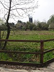 More images |
| Church of All Saints | Cockley Cley | Parish church | 13th century and later | 23 June 1960 | TF7917804186 52°36′21″N 0°38′41″E / 52.605902°N 0.644606°E / 52.605902; 0.644606 (Church of All Saints) | 1077261 |  More images |
| Church of St Mary | Colkirk | Parish church | 14th century and later | 30 May 1960 | TF9178526549 52°48′09″N 0°50′37″E / 52.80239°N 0.843572°E / 52.80239; 0.843572 (Church of St Mary) | 1077464 |  More images |
| Hall Farmhouse | Colkirk | Farmhouse | 16th century | 4 December 1951 | TF9245426676 52°48′12″N 0°51′13″E / 52.803293°N 0.853557°E / 52.803293; 0.853557 (Hall Farmhouse) | 1304756 |  |
| Pattesley House | Pattesley, Colkirk | Farmhouse | 14th century and later | 4 December 1951 | TF8984424107 52°46′52″N 0°48′48″E / 52.781151°N 0.8134°E / 52.781151; 0.8134 (Pattesley House) | 1077468 | Upload Photo |
| Church of St Andrew | Southburgh, Cranworth | Parish church | 14th century and later | 30 May 1960 | TG0032104832 52°36′16″N 0°57′24″E / 52.604325°N 0.956801°E / 52.604325; 0.956801 (Church of St Andrew) | 1172040 |  More images |
| Letton Hall | Cranworth | Country house | 1783–89 | 4 December 1951 | TF9717605872 52°36′53″N 0°54′40″E / 52.614812°N 0.911042°E / 52.614812; 0.911042 (Letton Hall) | 1077342 | 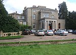 More images |
| Dereham Maltings (Crisp Malting Group) | Dereham | Industrial building | 1870 and 1894 | 27 July 2000 | TF9941913130 52°40′45″N 0°56′55″E / 52.679154°N 0.948509°E / 52.679154; 0.948509 (Dereham Maltings (Crisp Malting Group)) | 1246348 |  |
| West Hall | Didlington | House | 17th century | 18 February 1987 | TL7977294025 52°30′52″N 0°38′52″E / 52.514458°N 0.647864°E / 52.514458; 0.647864 (West Hall) | 1171962 | Upload Photo |
| Old Hall | East Tuddenham | Farmhouse | 16th century | 4 December 1951 | TG0880711092 52°39′26″N 1°05′09″E / 52.657327°N 1.085878°E / 52.657327; 1.085878 (Old Hall) | 1077351 | Upload Photo |
| Church of St Thomas | Foxley | Parish church | 14th century and later | 30 May 1960 | TG0395221714 52°45′16″N 1°01′15″E / 52.754528°N 1.020787°E / 52.754528; 1.020787 (Church of St Thomas) | 1169955 |  More images |
| Church of All Saints | Great Fransham, Fransham | Parish church | Late 13th century and later | 30 May 1960 | TF8989013104 52°40′56″N 0°48′28″E / 52.682341°N 0.807723°E / 52.682341; 0.807723 (Church of All Saints) | 1077471 | 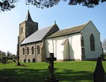 More images |
| Hyde Hall | Great Fransham, Fransham | Farmhouse | Mid-18th century | 14 June 1984 | TF9163412919 52°40′48″N 0°50′00″E / 52.680067°N 0.833381°E / 52.680067; 0.833381 (Hyde Hall) | 1077469 | Upload Photo |
| The Old Hall | Little Fransham, Fransham | Farmhouse | 16th century | 4 December 1951 | TF9028111866 52°40′16″N 0°48′46″E / 52.671088°N 0.812785°E / 52.671088; 0.812785 (The Old Hall) | 1152599 | Upload Photo |
| Garboldisham Windmill | Garboldisham | Windmill | c.1780 | 16 July 1958 | TM0027580472 52°23′08″N 0°56′29″E / 52.385637°N 0.941481°E / 52.385637; 0.941481 (Garboldisham Windmill) | 1168497 |  More images |
| Jacques | Garboldisham | Cross passage house | c.1490 | 21 July 1951 | TM0035181964 52°23′56″N 0°56′37″E / 52.399005°N 0.943488°E / 52.399005; 0.943488 (Jacques) | 1077445 | Upload Photo |
| Church of St Margaret | Garvestone | Parish church | 14th century | 30 May 1960 | TG0238207362 52°37′35″N 0°59′19″E / 52.626275°N 0.988739°E / 52.626275; 0.988739 (Church of St Margaret) | 1305274 |  More images |
| Guntons Farmhouse | Garvestone | Farmhouse | 18th century | 4 December 1951 | TG0162906868 52°37′20″N 0°58′38″E / 52.62212°N 0.977329°E / 52.62212; 0.977329 (Guntons Farmhouse) | 1342566 | Upload Photo |
| Reymerston Old Hall Farmhouse | Reymerston, Garvestone | Farmhouse | 1620 | 4 December 1951 | TG0144206352 52°37′03″N 0°58′27″E / 52.617557°N 0.974256°E / 52.617557; 0.974256 (Reymerston Old Hall Farmhouse) | 1342565 | Upload Photo |
| Church of St Andrew | Guist | Parish church | 13th century and later | 30 May 1960 | TG0002025606 52°47′27″N 0°57′54″E / 52.790937°N 0.964982°E / 52.790937; 0.964982 (Church of St Andrew) | 1306255 |  More images |
| Church of St Mary | Bodney, Hilborough | Parish church | 14th century and later | 23 June 1960 | TL8311898835 52°33′24″N 0°41′59″E / 52.556539°N 0.699765°E / 52.556539; 0.699765 (Church of St Mary) | 1077285 |  More images |
| Hilborough Hall | Hilborough | House | 1779 | 9 July 1951 | TF8276700304 52°34′11″N 0°41′43″E / 52.569848°N 0.695403°E / 52.569848; 0.695403 (Hilborough Hall) | 1077283 |  More images |
| Hilborough Mill | Hilborough | Mill house | 1819 | 30 October 1985 | TL8272699928 52°33′59″N 0°41′41″E / 52.566485°N 0.694591°E / 52.566485; 0.694591 (Hilborough Mill) | 1342591 |  More images |
| Church of St Andrew | Hoe | Parish church | 13th century | 30 May 1960 | TF9975616421 52°42′31″N 0°57′20″E / 52.708576°N 0.955483°E / 52.708576; 0.955483 (Church of St Andrew) | 1077329 |  More images |
| Church of St Margaret | Worthing, Hoe and Worthing | Parish church | 12th century and later | 30 May 1960 | TF9949619530 52°44′12″N 0°57′13″E / 52.736583°N 0.953526°E / 52.736583; 0.953526 (Church of St Margaret) | 1342577 | 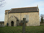 More images |
| Church of St Edmund | Horningtoft | Parish church | 13th century | 14 June 1984 | TF9361323080 52°46′14″N 0°52′07″E / 52.770593°N 0.868601°E / 52.770593; 0.868601 (Church of St Edmund) | 1304480 |  More images |
| Church of St Peter | Ickburgh | Parish church | 14th century | 23 June 1960 | TL8164495067 52°31′24″N 0°40′34″E / 52.523195°N 0.675988°E / 52.523195; 0.675988 (Church of St Peter) | 1077286 |  More images |
| Kenninghall Place | Kenninghall | House | 1505–25 | 21 July 1951 | TM0691785620 52°25′46″N 1°02′32″E / 52.429386°N 1.042114°E / 52.429386; 1.042114 (Kenninghall Place) | 1077419 | Upload Photo |
| Church of St Andrew | Kilverstone | Parish church | 12th century | 16 July 1958 | TL8938684014 52°25′17″N 0°47′01″E / 52.421314°N 0.783688°E / 52.421314; 0.783688 (Church of St Andrew) | 1342788 |  More images |
| Church of St Nicholas | West Lexham, Lexham | Parish church | 14th century, restored 1891 | 30 May 1960 | TF8425617211 52°43′16″N 0°43′36″E / 52.721164°N 0.726779°E / 52.721164; 0.726779 (Church of St Nicholas) | 1077485 |  More images |
| Pumphouse | Little Cressingham | Pump house | Early 19th century | 3 April 1987 | TF8696700215 52°34′03″N 0°45′26″E / 52.567623°N 0.757249°E / 52.567623; 0.757249 (Pumphouse) | 1077226 | 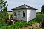 |
| Wind and Water Mill | Little Cressingham | Watermill | c.1820 | 9 July 1951 | TF8697900213 52°34′03″N 0°45′27″E / 52.567601°N 0.757425°E / 52.567601; 0.757425 (Wind and Water Mill) | 1152133 |  More images |
| Dunham Lodge | Little Dunham | Country house | 1783 | 4 December 1951 | TF8772912849 52°40′51″N 0°46′32″E / 52.680804°N 0.77565°E / 52.680804; 0.77565 (Dunham Lodge) | 1077493 |  More images |
| Church of St Peter | Little Ellingham | Parish church | Early 14th century | 16 November 1983 | TM0050899155 52°33′12″N 0°57′22″E / 52.553289°N 0.956125°E / 52.553289; 0.956125 (Church of St Peter) | 1342423 |  More images |
| Church of St Andrew and St Peter | Longham | Parish church | 15th century and later | 30 May 1960 | TF9318716189 52°42′32″N 0°51′30″E / 52.708875°N 0.858242°E / 52.708875; 0.858242 (Church of St Andrew and St Peter) | 1077331 | 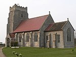 More images |
| Church of Our Lady of Consolation | Lynford | Roman Catholic church | 1879 | 18 February 1987 | TL8188293306 52°30′26″N 0°40′43″E / 52.507302°N 0.67853°E / 52.507302; 0.67853 (Church of Our Lady of Consolation) | 1077247 |  More images |
| Church of St Margaret | Lyng | Parish church | 13th century and later | 30 May 1960 | TG0690617855 52°43′08″N 1°03′43″E / 52.718765°N 1.062062°E / 52.718765; 1.062062 (Church of St Margaret) | 1169125 |  More images |
| Ivy Farmhouse | Mattishall | House | First half of 18th century | 4 December 1951 | TG0437610901 52°39′26″N 1°01′13″E / 52.657299°N 1.020346°E / 52.657299; 1.020346 (Ivy Farmhouse) | 1077328 | Upload Photo |
| Merton Hall Gatehouse | Merton | Gatehouse | 1620 | 21 July 1951 | TL9111697765 52°32′39″N 0°49′01″E / 52.544184°N 0.816977°E / 52.544184; 0.816977 (Merton Hall Gatehouse) | 1076830 |  |
| Cross in the churchyard 10 metres west of tower of Church of St John the Baptist | Mileham | Cross | 15th century | 14 June 1984 | TF9217619584 52°44′23″N 0°50′43″E / 52.739717°N 0.845281°E / 52.739717; 0.845281 (Cross in the churchyard 10 metres west of tower of Church of St John the Baptist) | 1342489 | Upload Photo |
| Church of St Leonard | Mundford | Parish church | 14th century | 23 June 1960 | TL8005293801 52°30′44″N 0°39′07″E / 52.512354°N 0.651865°E / 52.512354; 0.651865 (Church of St Leonard) | 1342617 |  More images |
| Narborough Hall | Narborough | Country house | Late 16th century | 9 July 1951 | TF7493713142 52°41′16″N 0°35′12″E / 52.687713°N 0.58679°E / 52.687713; 0.58679 (Narborough Hall) | 1077305 |  More images |
| Table tomb approximately 14 metres south of aisle of All Saints' Church | Necton | Chest tomb | 14th century | 3 April 1987 | TF8785809729 52°39′10″N 0°46′33″E / 52.652745°N 0.775779°E / 52.652745; 0.775779 (Table tomb approximately 14 metres south of aisle of All Saints' Church) | 1077228 | 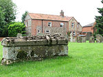 More images |
| Market House | New Buckenham | Toll house | 1559 | 9 February 1984 | TM0885390443 52°28′19″N 1°04′25″E / 52.471947°N 1.073562°E / 52.471947; 1.073562 (Market House) | 1306640 |  More images |
| Shettles | North Elmham | Farmhouse | 15th century | 4 December 1951 | TF9849621067 52°45′03″N 0°56′23″E / 52.75075°N 0.939665°E / 52.75075; 0.939665 (Shettles) | 1170168 | Upload Photo |
| Church of St Andrew | North Pickenham | Parish church | Pre-1863 | 23 June 1960 | TF8655406920 52°37′41″N 0°45′18″E / 52.627971°N 0.754939°E / 52.627971; 0.754939 (Church of St Andrew) | 1077229 |  More images |
| Abbey Farmhouse | Old Buckenham | Farmhouse | c.1550–60 | 16 July 1958 | TM0710492556 52°29′30″N 1°02′57″E / 52.491581°N 1.049163°E / 52.491581; 1.049163 (Abbey Farmhouse) | 1169388 |  More images |
| Old Buckenham Windmill | Old Buckenham | Windmill | 1818 | 21 July 1951 | TM0623590987 52°28′40″N 1°02′07″E / 52.477825°N 1.035412°E / 52.477825; 1.035412 (Old Buckenham Windmill) | 1342467 | 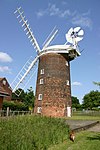 More images |
| Church of St. John Evangelist | Ovington | Parish church | 12th century | 16 July 1958 | TF9254402594 52°35′13″N 0°50′27″E / 52.58704°N 0.84081°E / 52.58704; 0.84081 (Church of St. John Evangelist) | 1076798 |  More images |
| Church of the Immaculate Conception of the Blessed Virgin Mary and St Margaret, Oxburgh Hall | Oxburgh Hall Park, Oxborough | Roman Catholic chapel | 1838 | 23 June 1960 | TF7414701269 52°34′53″N 0°34′08″E / 52.58134°N 0.568859°E / 52.58134; 0.568859 (Church of the Immaculate Conception of the Blessed Virgin Mary and St Margaret, Oxburgh Hall) | 1342587 | 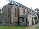 More images |
| Park boundary wall including tower and gateway, Oxburgh Hall | Oxburgh Hall Park, Oxborough | Tower | 15th century | 23 October 1985 | TF7398601224 52°34′52″N 0°33′59″E / 52.580987°N 0.566461°E / 52.580987; 0.566461 (Park boundary wall including tower and gateway, Oxburgh Hall) | 1306374 |  |
| Church of All Saints, including tower | Hargham, Quidenham | Church | 14th century | 16 July 1958 | TM0199291350 52°28′58″N 0°58′24″E / 52.482669°N 0.973245°E / 52.482669; 0.973245 (Church of All Saints, including tower) | 1077512 |  More images |
| Church of St Andrew | Quidenham | Parish church | Late 11th century | 16 July 1958 | TM0284087675 52°26′58″N 0°59′01″E / 52.449362°N 0.983482°E / 52.449362; 0.983482 (Church of St Andrew) | 1169567 |  More images |
| Church of St Mary | Eccles, Quidenham | Parish church | 12th century | 16 July 1958 | TM0191389356 52°27′53″N 0°58′15″E / 52.464797°N 0.970877°E / 52.464797; 0.970877 (Church of St Mary) | 1077510 |  More images |
| Wilby Hall | Wilby, Quidenham | Country house | Late 16th century | 9 February 1984 | TM0327390555 52°28′30″N 0°59′30″E / 52.475057°N 0.991598°E / 52.475057; 0.991598 (Wilby Hall) | 1077519 | 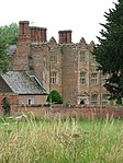 More images |
| Church of St Peter | Riddlesworth | Parish church | Early 14th century | 16 July 1958 | TL9666681284 52°23′39″N 0°53′20″E / 52.394235°N 0.888999°E / 52.394235; 0.888999 (Church of St Peter) | 1077393 |  More images |
| Dovecote to Rougham Hall | Rougham | Dovecote | c.1690 | 4 December 1951 | TF8298320606 52°45′07″N 0°42′35″E / 52.752081°N 0.709844°E / 52.752081; 0.709844 (Dovecote to Rougham Hall) | 1342500 | Upload Photo |
| Church of St Botolph | Stow Bedon | Parish church | 12th century | 21 July 1958 | TL9614695574 52°31′22″N 0°53′23″E / 52.522725°N 0.889761°E / 52.522725; 0.889761 (Church of St Botolph) | 1077585 | 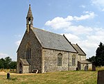 More images |
| Manor House including attached service range to east | Swaffham | House | c.1740 | 17 January 1973 | TF8241909030 52°38′54″N 0°41′42″E / 52.648323°N 0.695083°E / 52.648323; 0.695083 (Manor House including attached service range to east) | 1269575 | Upload Photo |
| Oakleigh House | Swaffham | House | Early 17th century | 10 January 1951 | TF8182608997 52°38′54″N 0°41′11″E / 52.648225°N 0.68631°E / 52.648225; 0.68631 (Oakleigh House) | 1269627 | 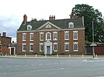 More images |
| Bell Hotel | Thetford | Jettied house | Mid-15th century | 3 April 1951 | TL8692483124 52°24′51″N 0°44′49″E / 52.414168°N 0.74703°E / 52.414168; 0.74703 (Bell Hotel) | 1195935 |  More images |
| Church of St Cuthbert | Thetford | Parish church | Early 13th century | 3 April 1951 | TL8712083067 52°24′49″N 0°45′00″E / 52.413589°N 0.749876°E / 52.413589; 0.749876 (Church of St Cuthbert) | 1207726 |  More images |
| Church of St Mary the Less | Thetford | Parish church | 11th century | 3 April 1951 | TL8678982822 52°24′41″N 0°44′42″E / 52.411502°N 0.744879°E / 52.411502; 0.744879 (Church of St Mary the Less) | 1297899 |  More images |
| Church of St Peter | Thetford | Parish church | 14th century | 3 April 1951 | TL8692783176 52°24′53″N 0°44′50″E / 52.414634°N 0.747103°E / 52.414634; 0.747103 (Church of St Peter) | 1219326 |  More images |
| Fulmerston's Almshouses | Thetford | Almshouse | 1610 | 3 April 1951 | TL8682282858 52°24′43″N 0°44′43″E / 52.411814°N 0.745384°E / 52.411814; 0.745384 (Fulmerston's Almshouses) | 1279468 | Upload Photo |
| Nunnery Place ruin approximately 10 metres south-east of the Nunnery | Nunnery Place, Thetford | Benedictine nunnery | c.1160–1540 | 3 April 1951 | TL8731682222 52°24′21″N 0°45′08″E / 52.405934°N 0.752282°E / 52.405934; 0.752282 (Nunnery Place ruin approximately 10 metres south-east of the Nunnery) | 1195915 |  |
| Roman Catholic Church of St Mary | Thetford | Roman Catholic church | 1826 | 3 April 1951 | TL8666182844 52°24′42″N 0°44′35″E / 52.411743°N 0.743012°E / 52.411743; 0.743012 (Roman Catholic Church of St Mary) | 1207963 | Upload Photo |
| The Nunnery | Nunnery Place, Thetford | House | Early 17th century | 3 April 1951 | TL8730282260 52°24′23″N 0°45′08″E / 52.40628°N 0.752098°E / 52.40628; 0.752098 (The Nunnery) | 1208030 |  |
| Thetford Warren Lodge | Thetford | Gamekeeper's lodge | Early 15th century | 10 March 1971 | TL8392984066 52°25′25″N 0°42′13″E / 52.423641°N 0.703564°E / 52.423641; 0.703564 (Thetford Warren Lodge) | 1297876 |  More images |
| 3 and 5 Castle Street | Thetford | House | Late 15th century | 3 April 1951 | TL8722483061 52°24′49″N 0°45′05″E / 52.4135°N 0.7514°E / 52.4135; 0.7514 (3 and 5 Castle Street) | 1207558 | Upload Photo |
| 3 and 4 Market Place | Thetford | Apartment | 16th century | 3 April 1951 | TL8718883087 52°24′49″N 0°45′03″E / 52.413745°N 0.750886°E / 52.413745; 0.750886 (3 and 4 Market Place) | 1207841 | Upload Photo |
| College Farmhouse | Thompson | House | 1350 | 21 July 1951 | TL9323296594 52°31′59″N 0°50′51″E / 52.532924°N 0.84746°E / 52.532924; 0.84746 (College Farmhouse) | 1076807 |  More images |
| Church of St Andrew | Tottington | Parish church | 14th century | 16 July 1958 | TL8939795521 52°31′29″N 0°47′25″E / 52.524635°N 0.790381°E / 52.524635; 0.790381 (Church of St Andrew) | 1342814 |  More images |
| Church of St Nicholas | Twyford | Parish church | 14th century | 30 May 1960 | TG0167724610 52°46′53″N 0°59′20″E / 52.78138°N 0.988907°E / 52.78138; 0.988907 (Church of St Nicholas) | 1170307 |  More images |
| Church of St. Mary | Watton | Parish church | 12th century | 16 July 1958 | TF9213500943 52°34′20″N 0°50′02″E / 52.57236°N 0.833824°E / 52.57236; 0.833824 (Church of St. Mary) | 1153046 |  More images |
| Church of All Saints | Weasenham All Saints | Parish church | 14th century, restored 1905–06 | 30 May 1960 | TF8508021612 52°45′37″N 0°44′29″E / 52.7604°N 0.741445°E / 52.7604; 0.741445 (Church of All Saints) | 1306499 |  More images |
| Church of St Peter | Weasenham St. Peter | Parish church | 13th century | 30 May 1960 | TF8561822355 52°46′01″N 0°44′59″E / 52.766887°N 0.749828°E / 52.766887; 0.749828 (Church of St Peter) | 1169531 |  More images |
| Church of St Mary | Weeting-with-Broomhill | Parish church | 14th century | 23 June 1960 | TL7766989192 52°28′18″N 0°36′52″E / 52.471744°N 0.614331°E / 52.471744; 0.614331 (Church of St Mary) | 1172178 |  More images |
| Church of St Andrew | Wellingham | Parish church | Late 13th century and later | 30 May 1960 | TF8709822257 52°45′56″N 0°46′18″E / 52.765497°N 0.771681°E / 52.765497; 0.771681 (Church of St Andrew) | 1077456 |  More images |
| Church of St Peter and Paul | Wendling | Parish church | 14th century, Norman fragments | 30 May 1960 | TF9313413134 52°40′53″N 0°51′20″E / 52.681465°N 0.855667°E / 52.681465; 0.855667 (Church of St Peter and Paul) | 1077339 |  More images |
| Church of St Andrew | Westfield, Whinburgh and Westfield | Parish church | 14th century | 30 May 1960 | TF9929709919 52°39′01″N 0°56′41″E / 52.650372°N 0.944767°E / 52.650372; 0.944767 (Church of St Andrew) | 1077294 |  More images |
| Old Hall | Whinburgh and Westfield | Farmhouse | c.1600 | 4 December 1951 | TG0150807909 52°37′53″N 0°58′34″E / 52.63151°N 0.976178°E / 52.63151; 0.976178 (Old Hall) | 1152045 | Upload Photo |
| Church of St Mary | Whissonsett | Parish church | Early 14th century and later | 30 May 1960 | TF9191923345 52°46′25″N 0°50′37″E / 52.773576°N 0.843679°E / 52.773576; 0.843679 (Church of St Mary) | 1077436 |  More images |
| Church of St Andrew | Illington, Wretham | Parish church | Early 15th century | 16 July 1958 | TL9481189994 52°28′23″N 0°52′01″E / 52.473103°N 0.866847°E / 52.473103; 0.866847 (Church of St Andrew) | 1170666 |  More images |
| Church of St Ethelbert | Wretham | Parish church | 12th century | 16 July 1958 | TL9150590632 52°28′48″N 0°49′07″E / 52.48°N 0.818603°E / 52.48; 0.818603 (Church of St Ethelbert) | 1170650 |  More images |
| Holland's Hall | Bakerfield Green, Yaxham | Farmhouse | Late 16th century | 4 December 1951 | TG0289109506 52°38′43″N 0°59′51″E / 52.645333°N 0.997565°E / 52.645333; 0.997565 (Holland's Hall) | 1152070 | Upload Photo |
See also
Notes
- ^ The date given is the date used by Historic England as significant for the initial building or that of an important part in the structure's description.
- ^ Sometimes known as OSGB36, the grid reference is based on the British national grid reference system used by the Ordnance Survey.
- ^ The "List Entry Number" is a unique number assigned to each listed building and scheduled monument by Historic England.
External links
- v
- t
- e
- Bedfordshire
- Berkshire
- Bristol
- Buckinghamshire
- Cambridgeshire
- Cheshire
- Cornwall
- Cumbria
- Derbyshire
- Devon
- Dorset
- Durham
- East Sussex
- East Riding of Yorkshire
- Essex
- Gloucestershire
- Greater London
- Greater Manchester
- Hampshire
- Herefordshire
- Hertfordshire
- Isle of Wight
- Kent
- Lancashire
- Leicestershire
- Lincolnshire
- Merseyside
- Norfolk
- North Yorkshire
- Northamptonshire
- Northumberland
- Nottinghamshire
- Oxfordshire
- Rutland
- Shropshire
- Somerset
- South Yorkshire
- Staffordshire
- Suffolk
- Surrey
- Tyne and Wear
- Warwickshire
- West Midlands
- West Sussex
- West Yorkshire
- Wiltshire
- Worcestershire
- Allerdale
- Amber Valley
- Ashford
- Babergh
- Barrow-in-Furness
- Basildon
- Basingstoke and Deane
- Bath and North East Somerset
- Bolsover
- Boston
- Bournemouth
- Bradford
- Braintree
- Breckland
- Brentwood
- Brighton and Hove
- Bristol
- Broadland
- Calderdale
- Cambridge
- Camden
- Canterbury
- Carlisle
- Castle Point
- Chelmsford
- Cheltenham
- Cherwell
- Cheshire East
- Cheshire West and Chester
- Chesterfield
- Chiltern
- Christchurch
- Colchester
- Copeland
- Corby
- Cotswold
- Dartford
- Daventry
- Dover
- East Cambridgeshire
- Exeter
- Mendip
- North Somerset
- North Yorkshire (district)
- Poole
- Sedgemoor
- South Somerset
- Stoke-on-Trent
- Taunton Deane
- West Somerset
- York


