Fan District
United States historic place
Fan Area Historic District | |
Virginia Landmarks Register | |
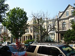 A street in the Fan | |
37°33′9″N 77°27′56″W / 37.55250°N 77.46556°W / 37.55250; -77.46556 | |
| Area | 228 acres (92 ha) |
|---|---|
| Architect | Multiple |
| Architectural style | Mid 19th Century Revival, Late 19th-20th Century Revivals, Late Victorian |
| NRHP reference No. | 85002243[1] |
| VLR No. | 127-0248 |
| Significant dates | |
| Added to NRHP | September 12, 1985 |
| Designated VLR | August 13, 1985[2] |
The Fan is a district of Richmond, Virginia, so named because of the "fan" shape of the array of streets that extend west from Belvidere Street, on the eastern edge of Monroe Park, westward to Arthur Ashe Boulevard. However, the streets rapidly resemble a grid after they go through what is now Virginia Commonwealth University. The Fan is one of the easterly points of the city's West End section, and is bordered to the north by Broad Street and to the south by VA 195, although the Fan District Association considers the southern border to be the properties abutting the south side of Main Street.[3] The western side is sometimes called the Upper Fan and the eastern side the Lower Fan, though confusingly the Uptown district is located near VCU in the Lower Fan.[citation needed] Many cafes and locally owned restaurants are located here, as well as historic Monument Avenue, a boulevard formerly featuring statuary of the Civil War's Confederate president and generals. The only current statue is a more modern one of tennis icon Arthur Ashe. Development of the Fan district was strongly influenced by the City Beautiful movement of the late 19th century.
The Fan District is primarily a residential neighborhood consisting of late-nineteenth and early-twentieth century homes. It is also home to VCU's Monroe Park Campus, several parks, and tree-lined avenues. The District also has numerous houses of worship, and locally owned businesses and commercial establishments. The Fan borders and blends with the Boulevard, the Museum District, and the Carytown district, which features the ornate Byrd Theatre.
Main east-west thoroughfares include Broad Street, Grace Street, Monument Avenue, Patterson Avenue, Grove Avenue, Floyd Avenue, Main Street, Parkwood Ave, and Cary Street.
Architecture

Following a succession of owners, an architecture museum, the Virginia Center for Architecture, took occupancy in 2005 of Branch House on Monument Avenue, a residence designed in the Tudor style by the firm of John Russell Pope in 1914.
The Fan is known for having one of the longest intact stretches of Victorian architecture in the United States, however much of the housing stock was actually built after the end of the Victorian era and is arguably more Edwardian and Revival in style.[citation needed] While housing in the Eastern parts of the neighborhood are quintessential Victorian styles, such as Italianate and Queen Anne, housing stock further west was constructed in the first decades of the twentieth century and exhibits the pared back victorianism of Edwardian architecture. Homes still contain gables and turrets, but detail is normally executed in a simplified classical form. Colonial Revival and American Craftsman architecture are common as well, with Revival architectural types arguably the most common (as was common to the time period) Revivalism (architecture).[citation needed]

Primary architectural styles represented include:
Other architectural styles include:
- Tudor Revival
- Second Empire
- Beaux-Arts
- Art Deco
- Spanish
- Gothic Revival
- Bungalow
- American Arts and Crafts Movement
- James River Georgian
- Southern Colonial
- Jacobethan (Jacobean Revival)
- Federal
History

In 1817, the Fan was plotted as the village of Sydney on land formerly owned by William Byrd II. Primary development of the Fan occurred after the Civil War through about 1920. Streetcar lines leading from downtown influenced development; the nation's first electric streetcar system was inaugurated in Richmond in 1888.
As development increased from downtown at the turn of the 20th century, Franklin street became a fashionable "West End" address. A desire for a West End address drove rapid real estate development of the area, changing the area from rural tobacco fields in 1880 to being almost fully developed land by the 1920s. As development accelerated, the University of Richmond (then located on Lombardy Street) was moved west to a more rural location (its present Westhampton location). During the Great Depression, many of the single-family homes in the area were converted to apartments.

The term "the Fan" was coined in the mid 20th century by a Richmond Times Dispatch editorial, as the appellation "West End" no longer applied. In 1985, the Fan was added to the National Register of Historic Places, and various buildings around the Fan are adorned with plaques noting this and when the building was built.[4]
Maps
-
 The boundaries of the Fan.
 -
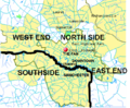 Richmond is often subdivided into North Side, Southside, East End and West End.
 -
 The Fan is one of many other Neighborhoods of Richmond Virginia


References
- ^ "National Register Information System". National Register of Historic Places. National Park Service. March 13, 2009.
- ^ "Virginia Landmarks Register". Virginia Department of Historic Resources. Archived from the original on September 21, 2013. Retrieved March 19, 2013.
- ^ "Area Map ‹ Fan District Association". Archived from the original on September 3, 2013. Retrieved August 23, 2013.
- ^ "127-0248". DHR. Archived from the original on June 2, 2023. Retrieved June 2, 2023.
External links
![]() Media related to Fan Area Historic District at Wikimedia Commons
Media related to Fan Area Historic District at Wikimedia Commons
- The Fan District Association
- History of the Fan: A series of historical narratives by Fan District Association Historian Gail Zwirner
- Fan of the Fan (community news blog)
- Fan of the Fan: A look at the history and architecture of the Fan Area Historic District
- Wikimapia
- v
- t
- e
- Arts District
- Banking District
- Biotech and MCV
- Central Office District
- City Center
- Court End
- East Franklin Block
- Financial District
- French Garden Hill
- Gambles Hill
- Jackson Ward
- Monroe Ward
- Riverside District
- Shockoe Bottom
- Shockoe Slip
- Upper Shockoe Valley
- Allen Heights
- Alton Heights
- Ashley Oaks
- Belmont
- Bolton and Taliaferrol
- Bowling Green
- Brauers
- Briels
- Cardinal Court
- Chimborazo
- Chimborazo Village
- Church Hill
- Church Hill North
- Creighton Court
- Eastlawn
- Eastview
- Fairfield
- Fairmount
- Fulton Hill
- Geffert Place
- Glenwood
- Guildts Estates
- Habitat Hills
- Harrison Place
- Howard's Grove
- Kuhn
- Libby Hill
- Linsville
- Mechaniscville Gardens
- Montrose Heights
- Mosby
- Mount Erin
- Montibello
- National Heights
- Navy Hill
- North Church Hill
- Oakwood
- Overhill Place
- Payne Square
- Peter Paul
- Powhatan
- Rainbow Village
- Rico
- Robinson Heights
- Rocketts Landing
- Rutherford Tract
- Shed Town
- Silver Crest
- Tobacco Row
- Tuxedo Park
- Union Hill
- Witcomb Court
- Wynwood
- Battery Court
- Barton Heights
- Bellevue
- Brookland Park
- Chamberlayne Industrial Center
- Chestnut Hill
- Chestnut Hill–Plateau
- Edgewood
- Gilpin
- Ginter Park
- Green Park
- Hermitage Road
- Highland Park
- Highland Terrace
- Laburnum Park
- Magnolia Industrial Center
- North Highland Park
- Pine Camp
- Providence Park
- Rosedale
- Sherwood Park
- Southern Barton Heights
- Virginia Union University
- Washington Park
- Ancarrow's Landing
- Ann's Acres
- Bellemeade
- Belmont Woods
- Blackwell
- Broad Rock
- Brookbury
- Brookside
- Buck Hill
- Cedarhurst
- Cherry Gardens
- Chippenham Forest
- Claremont
- Clopton
- Cofer
- Cotrell Farms
- Dorchester
- Fairway Acres
- Forest Hill
- Gravel Hill
- Hickory Hill
- Hillside Court
- Hioaks
- Holmes Heights
- Huguenot
- Jahnke
- Manchester
- Mason Park
- Maury
- McGuire
- Newell
- Newtown South
- Northrop
- Oak Grove
- Old Town Manchester
- Oxford
- Piney Knolls
- Pocosham Park
- Purcell's Addition
- Robertson & Bradley's Addition
- Saint John's Woods
- South Richmond
- Southampton
- Stratford Hills
- Swansboro
- Thurston & Taylor's Addition
- Warwick
- Westlake Hills
- Westover Court
- Windsor
- Woodhaven
- Woodland Heights
- Woodland Park
- Woolfolk
- Worthington
- 2900 Block of Grove
- Bays Meade
- Boulevard
- Byrd Park
- Carillon
- Carver
- Carver Industrial
- Carytown
- Chinatown
- Club View
- Colonial Place
- Dahlia Farms
- Duntreath
- The Fan
- Garrett Manor
- Greek Row
- Hampton Gardens
- Hampton Hills
- Harvey
- Henry Place
- Huguenot Farms
- Lee Mac
- Leonard Heights
- Lockgreen
- Malvern Gardens
- Malven Manor
- Mapleshade
- Maymont
- Monument Heights
- Monument Hills
- Museum District
- Nash Plan
- Near West End
- Newtowne West
- Oregon Hill
- Patterson Place
- Portland Place
- Randolph
- Rio Vista
- Rhoadmiller
- Roselawn
- Rothesay
- Sauer's Gardens
- Scott's Addition
- Stonehurst Court
- Stonewall Court
- Sunnyside
- Sydney
- Sydnor's Point
- Texas Beach
- Three Chopt
- Tuckahoe Terrace
- Virginia Commonwealth University
- West Broad Street Commercial Historic District
- West of the Boulevard
- Westhampton
- Willow Lawn
- Wilton
- Windemere
- Windsor Farms
- Windsor Hills
Places adjacent to Fan District | |
|---|---|


