South Bedfordshire
| South Bedfordshire | |||
|---|---|---|---|
| | |||
| Land |  Storbritannia Storbritannia | ||
| Konst. land |  England England | ||
| Region | Øst-England | ||
| Adm. grevskap | Bedfordshire | ||
| Seremonielt grevskap | Bedfordshire | ||
| Status | Tidligere distrikt | ||
| Adm. senter | Dunstable | ||
| Areal | 212,82 km² | ||
| Befolkning | 113 367 (2002) | ||
| Bef.tetthet | 532,69 innb./km² | ||
| ONS-kode | 09UE | ||
 South Bedfordshire 51°55′00″N 0°33′00″V | |||
South Bedfordshire på Commons | |||
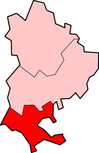
South Bedforshire var et distrikt i Bedfordshire, England. Administrasjonssenteret var Dunstable.
Distriktet ble opprettet 1. april 1974 da Dunstable, Leighton Buzzard, Luton landdistrikt og Amtphill landdistrikt ble slått sammen. I 2009 ble South Bedfordshire slått sammen med Mid Bedfordshire til Central Bedfordshire.
Steder i distriktet
- Dunstable
- Houghton Regis
- Leighton Buzzard
- v
- d
- r
Distrikter i Øst-England

Babergh · Basildon · Bedford · Braintree · Breckland · Brentwood · Broadland · Broxbourne · Cambridge · Castle Point · Central Bedfordshire · Chelmsford · Colchester · Dacorum · East Cambridgeshire · East Hertfordshire · Epping Forest · Fenland · Forest Heath · Great Yarmouth · Harlow · Hertsmere · Huntingdonshire · Ipswich · King’s Lynn and West Norfolk · Luton · Maldon · Mid Suffolk · North Hertfordshire · North Norfolk · Norwich · Peterborough · Rochford · St. Albans · St. Edmundsbury · South Cambridgeshire · Southend-on-Sea · South Norfolk · Stevenage · Suffolk Coastal · Tendring · Three Rivers · Thurrock · Uttlesford · Watford · Waveney · Welwyn Hatfield

Administrative grevskap med flere distrikter: Bedfordshire - Cambridgeshire - Essex - Hertfordshire - Norfolk - Suffolk


