Bayugan
| Bayugan | |||
|---|---|---|---|
 | |||
| | |||
| Land |  Filippinene Filippinene | ||
| Status | by | ||
| Grunnlagt | 20. august 1961 | ||
| Postnummer | 8502 | ||
| Retningsnummer | 85 | ||
| Areal | 688,77 km²[1] | ||
| Befolkning | 109 499[2] (2020) | ||
| Bef.tetthet | 158,98 innb./km² | ||
| Antall husholdninger | 26 259 | ||
| Språk | Agusan, Butuanon, cebuano, Higaonon, tagalog | ||
| Høyde o.h. | 270 meter | ||
| Nettside | www | ||
 Bayugan 8°42′51″N 125°44′53″Ø | |||
Bayugan på Commons | |||


Bayugan er en by på Filippinene i provinsen Agusan del Sur på Mindanao.
Galleri
-
 En blomster float under en float-konkurranse i forbindelse med Rice Corn and Flower Festival.
 -
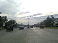 Narra Avenue har vært et transportknutepunkt i Mindanao.
 -
 Bayugan sett fra Santa Irene.
 -
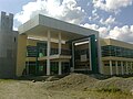 Bayugan City Division of the Department of Education.
 -
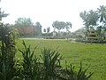 Bayugan Rizal Park Plaza


Referanser
- ^ http://nap.psa.gov.ph/activestats/psgc/province.asp?provCode=160300000; arkiveringsdato: 12. oktober 2016; arkiv-URL: https://web.archive.org/web/20161012231548/http://nap.psa.gov.ph/activestats/psgc/province.asp?provCode=160300000.
- ^ «2020 Census of Population and Housing (2020 CPH) Population Counts Declared Official by the President». folketellingen 2020. Filippinenes statistikkbyrå. 7. juli 2021.
Eksterne lenker
- Offisielt nettsted

- (en) Bayugan – kategori av bilder, video eller lyd på Commons


