Montmirat
Gemeente in Frankrijk  | |||
|---|---|---|---|
 | |||
  | |||
| Situering | |||
| Regio | Occitanie | ||
| Departement | Gard (30) | ||
| Arrondissement | Nîmes | ||
| Kanton | Calvisson | ||
| Coördinaten | 43° 55′ NB, 4° 6′ OL | ||
| Algemeen | |||
| Oppervlakte | 9,52 km² | ||
| Inwoners (1 januari 2021) | 487[1] (51 inw./km²) | ||
| Hoogte | 58 - 270 m | ||
| Overig | |||
| Postcode | 30260 | ||
| INSEE-code | 30181 | ||
| Website | Officiële website | ||
| Foto's | |||
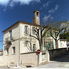 | |||
| Gemeentehuis en -school | |||
| |||

Montmirat is een gemeente in het Franse departement Gard (regio Occitanie) en telt 167 inwoners (1999). De plaats maakt deel uit van het arrondissement Nîmes.
Geografie
De oppervlakte van Montmirat bedraagt 9,5 km², de bevolkingsdichtheid is 17,6 inwoners per km².

Demografie
Onderstaande figuur toont het verloop van het inwonertal (bron: INSEE-tellingen).

Externe links
- (fr) Statistische informatie op de website van INSEE
Mediabestanden
Zie de categorie Montmirat van Wikimedia Commons voor mediabestanden over dit onderwerp.
- ↑ Populations légales 2021.


