Méhoncourt
Gemeente in Frankrijk  | |||
|---|---|---|---|
 | |||
  | |||
| Situering | |||
| Regio | Grand Est | ||
| Departement | Meurthe-et-Moselle (54) | ||
| Arrondissement | Lunéville | ||
| Kanton | Lunéville-2 | ||
| Coördinaten | 48° 31′ NB, 6° 23′ OL | ||
| Algemeen | |||
| Oppervlakte | 7,87 km² | ||
| Inwoners (1 januari 2021) | 246[1] (31 inw./km²) | ||
| Hoogte | 262 - 358 m | ||
| Overig | |||
| Postcode | 54360 | ||
| INSEE-code | 54359 | ||
| Foto's | |||
 | |||
| Gemeentehuis | |||
| |||

Méhoncourt is een gemeente in het Franse departement Meurthe-et-Moselle (regio Grand Est) en telt 207 inwoners (1999). De plaats maakt deel uit van het arrondissement Lunéville.
Geografie
De oppervlakte van Méhoncourt bedraagt 7,7 km², de bevolkingsdichtheid is 26,9 inwoners per km².
De onderstaande kaart toont de ligging van Méhoncourt met de belangrijkste infrastructuur en aangrenzende gemeenten.
 |
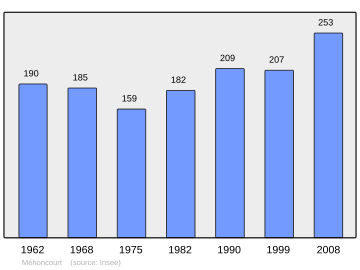
Demografie
De figuur toont het verloop van het inwonertal (bron: INSEE-tellingen).
Externe links
- (fr) Statistische informatie op de website van INSEE
Gemeenten in het kanton Lunéville-2
Barbonville · Bayon · Blainville-sur-l'Eau · Borville · Brémoncourt · Chanteheux · Charmois · Clayeures · Damelevières · Domptail-en-l'Air · Einvaux · Essey-la-Côte · Ferrières · Fraimbois · Franconville · Froville · Gerbéviller · Giriviller · Haigneville · Haussonville · Hériménil · Haudonville · Lamath · Landécourt · Lorey · Loromontzey · Lunéville · Magnières · Mattexey · Méhoncourt · Moncel-lès-Lunéville · Mont-sur-Meurthe · Moriviller · Moyen · Rehainviller · Remenoville · Romain · Rosières-aux-Salines · Rozelieures · Saffais · Saint-Boingt · Saint-Germain · Saint-Mard · Saint-Rémy-aux-Bois · Seranville · Tonnoy · Vallois · Vathiménil · Velle-sur-Moselle · Vennezey · Vigneulles · Villacourt · Virecourt · Xermaménil
Mediabestanden
Zie de categorie Méhoncourt van Wikimedia Commons voor mediabestanden over dit onderwerp.
- ↑ Populations légales 2021.


