Ashfield (Nottinghamshire)
Niet-metropolitaans district in Engeland  | |||
|---|---|---|---|
  | |||
| Situering | |||
| Land | Engeland | ||
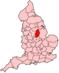
| County | Nottinghamshire | ||
| Regio | East Midlands | ||
| Coördinaten | 53°3'NB, 1°18'WL | ||
| Algemeen | |||
| Oppervlakte | 109,5581[1] km² | ||
| Inwoners (2001) | 111.387 (1017 inw./km²) | ||
| ONS-code | E07000170 | ||
| Detailkaart | |||
 | |||
| |||

Ashfield is een Engels district in het shire-graafschap (non-metropolitan county OF county) Nottinghamshire en telt 111.387 inwoners. De oppervlakte bedraagt 110 km².
Van de bevolking is 15,7% ouder dan 65 jaar. De werkloosheid bedraagt 4,2% van de beroepsbevolking (cijfers volkstelling 2001).
Plaatsen in district Ashfield
- Annesley Woodhouse
- Hucknall
- Huthwaite
- Jacksdale
- Kirkby-in-Ashfield
- Stanton Hill
- Sutton-in-Ashfield
- Teversal
- Underwood
Civil parishes in district Ashfield
- Annesley
- Felley
- Selston
Bronnen, noten en/of referenties
- ↑ Office for National Statistics → Download → SAM_for_Administrative_Areas_(2017).zip → SAM_LAD_DEC_2017_UK.xlsx. Gearchiveerd op 9 mei 2019.
- Volkstelling 2001, Office for National Statistics


