Sankt Radegund bei Graz

Cet article est une ébauche concernant une localité autrichienne.
Vous pouvez partager vos connaissances en l’améliorant (comment ?) selon les recommandations des projets correspondants.
| Sankt Radegund bei Graz | ||||
 Héraldique | ||||
 Sankt Radegund bei Graz vue du Schöckl. | ||||
| Administration | ||||
|---|---|---|---|---|
| Pays |  Autriche Autriche | |||
| Land |  Styrie Styrie | |||
| District (Bezirk) | District de Graz-Umgebung | |||
| Code postal | A-8061 | |||
| Immatriculation | GU | |||
| Indicatif | +43(0)3132 | |||
| Démographie | ||||
| Population | 2 165 hab. ([1]) | |||
| Densité | 100 hab./km2 | |||
| Géographie | ||||
| Coordonnées | 47° 10′ 52″ nord, 15° 29′ 22″ est | |||
| Altitude | 717 m | |||
| Superficie | 2 160 ha = 21,6 km2 | |||
| Localisation | ||||
| Géolocalisation sur la carte : Autriche
Géolocalisation sur la carte : Autriche
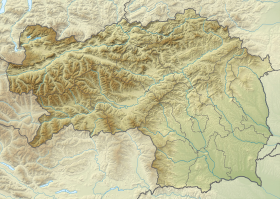
Géolocalisation sur la carte : Styrie
| ||||
modifier  | ||||


Sankt Radegund bei Graz (souvent abrégé en St. Radegund ; « Sainte-Radegonde-lès-Graz » en français) est une commune autrichienne du district de Graz-Umgebung en Styrie.
Géographie

Sankt Radegund bei Graz se situe à 13 km à vol d’oiseau au nord-nord-est de Graz. Le village se trouve au pied du mont Schöckl, dont le sommet appartient au territoire de la commune.
La commune comprend huit localités (Ortschaften)[2] :
- Diepoltsberg (234 habitants),
- Ebersdorf (177 habitants),
- Kickenheim (115 habitants),
- Rinnegg (532 habitants),
- Sankt Radegund bei Graz (790 habitants),
- Schöckl (123 habitants),
- Willersdorf (173 habitants au 1er janvier 2020).
Histoire

Cette section est vide, insuffisamment détaillée ou incomplète. Votre aide est la bienvenue ! Comment faire ?

Notes et références

 Portail de l'Autriche


