Yallah, New South Wales
Suburb of Wollongong, New South Wales, Australia
34°32′S 150°48′E / 34.533°S 150.800°E / -34.533; 150.800| Suburbs around Yallah: | ||
| Avondale | Dapto | Koonawarra |
| Marshall Mount | Yallah | Lake Illawarra |
| Calderwood | Albion Park Rail | Haywards Bay |
Yallah is a western suburb in the City of Wollongong, New South Wales, Australia, located on the western shore of Lake Illawarra. It contains a mixture of rural, commercial and light industrial areas.
Etymology
Yallah is an Australian Aboriginal word for which a number of meanings are given; native apple tree, a nearby lagoon, and "go away at once".[2]
Developments
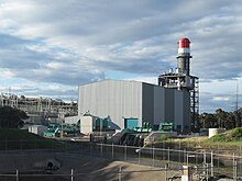
The Tallawarra Power Station on the shores of Lake Illawarra and adjacent to Yallah was commissioned in 1952 and commenced operations in 1954 as a thermal power station. The station closed in 1989 and was reconditioned as a 435-megawatt (583,000 hp) combined cycle natural gas power station.[2]
The Yallah railway station opened in 1887,[2] and closed in 1974.[3]
The Princes Motorway southern terminus is located south of Yallah and north of Albion Park Rail, at the junction of the Princes Highway with the Illawarra Highway.
See also
 New South Wales portal

References
- ^ Australian Bureau of Statistics (28 June 2022). "Yallah (suburb and locality)". Australian Census 2021 QuickStats. Retrieved 28 June 2022.

- ^ a b c "Online resources: Suburb Profiles". City of Wollongong. 19 October 2012. Archived from the original on 20 June 2018. Retrieved 10 October 2016.
In 1823 William Browne, generally known as "Merchant Browne", received a grant of 3000 acres facing Lake Illawarra and a grant of 800 acres fronting the Macquarie Rivulet. This property was originally called Athanlin but later became known as Yallah. Athanlin was later purchased by Henry Osborne. A 164 acre grant issued to P Larkins on 30 January 1837 is described as "at Yalla". Yallah is an aboriginal word for which a number of meanings are given; native apple tree; a nearby lagoon; "go away at once".
- ^ "Yallah Station". www.nswrail.net. Retrieved 7 February 2016.
- v
- t
- e
Suburbs and localities of Wollongong, New South Wales
- Albion Park
- Albion Park Rail
- Austinmer
- Avon
- Avondale
- Balarang
- Balgownie
- Barrack Heights
- Barrack Point
- Bellambi
- Berkeley
- Blackbutt
- Bombo
- Broughton Village
- Brownsville
- Bulli
- Burning Palms
- Calderwood
- Carrington Falls
- Cleveland
- Clifton
- Coalcliff
- Coledale
- Coniston
- Cordeaux
- Cordeaux Heights
- Corrimal
- Cringila
- Croom
- Curramore
- Dapto
- Darkes Forest
- Dombarton
- Dunmore
- East Corrimal
- Fairy Meadow
- Farmborough Heights
- Fernhill
- Figtree
- Flinders
- Foxground
- Gerringong
- Gerroa
- Gwynneville
- Haywards Bay
- Helensburgh
- Horsley
- Huntley
- Jamberoo
- Jerrara
- Kanahooka
- Keiraville
- Kembla Grange
- Kembla Heights
- Kemblawarra
- Kiama
- Kiama Downs
- Kiama Heights
- Knights Hill
- Koonawarra
- Lake Heights
- Lake Illawarra
- Lilyvale
- Macquarie Pass
- Maddens Plains
- Mangerton
- Marshall Mount
- Minnamurra
- Mount Keira
- Mount Kembla
- Mount Ousley
- Mount Pleasant
- Mount Saint Thomas
- Mount Warrigal
- North Macquarie
- North Wollongong
- Oak Flats
- Otford
- Port Kembla
- Primbee
- Rose Valley
- Russell Vale
- Saddleback Mountain
- Scarborough
- Shell Cove
- Shellharbour
- Shellharbour City Centre
- Spring Hill
- Stanwell Park
- Stanwell Tops
- Tarrawanna
- Thirroul
- Tongarra
- Toolijooa
- Towradgi
- Tullimbar
- Unanderra
- Upper Kangaroo Valley
- Warilla
- Warrawong
- Werri Beach
- West Wollongong
- Willow Vale
- Windang
- Wollongong
- Wombarra
- Wongawilli
- Woonona
- Yallah
- Yellow Rock
other nature reserves
- Bulli Pass
- Illawarra escarpment
- Kangaroo Valley
- Macquarie Pass
- Saddleback Mountain
 | This Wollongong geography article is a stub. You can help Wikipedia by expanding it. |
- v
- t
- e


