Wabuda Island
Island in Papua New Guinea
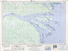
Wabuda Island is the third largest island in the Fly River delta, Papua New Guinea, after Kiwai Island and Purutu Island. Its area is 109 km2 (42 sq mi).
Administratively, the island belongs to Kiwai Rural LLG in South Fly District of Western Province.
See also
- Waboda language
- v
- t
- e
Islands of Papua New Guinea
- Ali
- Brumer
- D'Entrecasteaux Islands
- Dobu
- Fergusson
- Goodenough
- Normanby
- Sanaroa
- Wagifa
- Dart Reefs
- Daru
- Goaribari
- Kiwai
- Mailu
- New Guinea
- Nuakata
- Nukumanu
- Purutu
- Seleo
- Trobriands
- Tumleo
- Vitu Islands
- Wabuda
- Woodlark
- Yule
- Admiralty Islands
- Baudisson
- Bagabag
- Duke of York Islands
- Dyaul
- Feni Islands
- Karkar
- Lihir Group
- Long
- Manam
- Manne
- New Britain
- New Hanover
- New Ireland
- Patio
- Ritter
- St Matthias Islands
- Sakar
- Schouten Islands
- Selapiu
- Tabar Group
- Tanga Islands
- Tolokiwa
- Tsoilaunung
- Umboi
- Western Islands
- Bonvouloir Islands
- East
- Hastings
- Strathord Islands
- Calvados Chain
- Conflict Group
- Daloloia Group
- Deboyne Islands
- Duchateau Islands
- Dumoulin Islands
- Engineer Islands
- Misima
- Jomard Islands
- Pana Tinani
- Pocklington Reef
- Renard Islands
- Rossel (Yela)
- Samarai Islands
- Vanatinai
- Yeina
- Bougainville
- Buka
- Carteret Islands
- Green Islands
- Takuu
 Islands portal
8°23′S 143°37′E / 8.383°S 143.617°E / -8.383; 143.617
 | This Gulf Province geography article is a stub. You can help Wikipedia by expanding it. |
- v
- t
- e


