Uliga
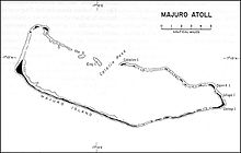
Uliga (Marshallese: Wūlka, [wɯlʲ(i)ɡɑ][1]) is an island district in the Marshall Islands, located in the eastern portion of Majuro Atoll. Along with Delap and Djarrit, it forms a town known as "Delap-Uliga-Djarrit".
The terrain is about 2 metres above sea level. Variant forms of spelling for Majuro Uliga exist in several different languages: Urego To, Uliga Island, Vuleka, Ulika, Ulliga, Urega-tō, Uliga Island, Ulika, Ulliga, Urega-to, Urega-tō, Urego To, Vuleka.[2]
On January 30, 1944, United States troops invaded and built a large base, Naval Base Majuro. [3][4]
Climate
| Climate data for Kaven | |||||||||||||
|---|---|---|---|---|---|---|---|---|---|---|---|---|---|
| Month | Jan | Feb | Mar | Apr | May | Jun | Jul | Aug | Sep | Oct | Nov | Dec | Year |
| Mean daily maximum °C (°F) | 29 (84) | 29 (84) | 29 (84) | 29 (84) | 29 (84) | 29 (84) | 29 (84) | 30 (86) | 30 (86) | 30 (86) | 30 (86) | 29 (84) | 29 (84) |
| Mean daily minimum °C (°F) | 24 (75) | 24 (75) | 24 (75) | 24 (75) | 24 (75) | 24 (75) | 24 (75) | 24 (75) | 24 (75) | 24 (75) | 24 (75) | 24 (75) | 24 (75) |
| Average precipitation cm (inches) | 20 (8) | 17 (6.7) | 21 (8.3) | 28 (11) | 30 (11.7) | 30 (11.7) | 33 (12.9) | 29 (11.5) | 33 (12.8) | 36 (14.3) | 34 (13.3) | 28 (11.1) | 338 (133.2) |
| Source: Weatherbase [5] | |||||||||||||
7°05′14.28″N 171°22′34.72″E / 7.0873000°N 171.3763111°E / 7.0873000; 171.3763111
References
- ^ Marshallese-English Dictionary - Place Name Index
- ^ - geoview.info
- ^ "Marshall Islands -- Building the Navy's Bases -- Majuro Naval Base". marshall.csu.edu.au.
- ^ Majuro Atollpacificwrecks.com
- ^ "Weatherbase: Historical Weather for Kaven, Marshall Islands". Weatherbase. 2011. Retrieved on November 24, 2011.
- v
- t
- e


