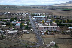
Tsaghkahovit
40°38′10″N 44°13′23″E / 40.63611°N 44.22306°E / 40.63611; 44.22306
Place in Aragatsotn, Armenia
Tsaghkahovit Ծաղկահովիտ | |
|---|---|
 | |
 Coat of arms | |
  Tsaghkahovit  Tsaghkahovit | |
| Coordinates: 40°38′10″N 44°13′23″E / 40.63611°N 44.22306°E / 40.63611; 44.22306 | |
| Country | Armenia |
| Province | Aragatsotn |
| Municipality | Tsaghkahovit |
| Elevation | 2,011 m (6,598 ft) |
| Population (2011) | |
| • Total | 1,611 |
| Time zone | UTC+4 |
Tsaghkahovit (Armenian: Ծաղկահովիտ), known as Haji Khalil until 1946,[1] is a village in the Tsaghkahovit Municipality of the Aragatsotn Province of Armenia.
Climate
Tsaghkahovit has a humid continental climate (Koppen Classification:Dfb)with mild summers and very cold winters.
| Climate data for Tsaghkahovit (1991-2020) | |||||||||||||
|---|---|---|---|---|---|---|---|---|---|---|---|---|---|
| Month | Jan | Feb | Mar | Apr | May | Jun | Jul | Aug | Sep | Oct | Nov | Dec | Year |
| Record high °C (°F) | 6.5 (43.7) | 9 (48) | 17.5 (63.5) | 23.2 (73.8) | 24.9 (76.8) | 28.2 (82.8) | 32.7 (90.9) | 33 (91) | 31.2 (88.2) | 24.1 (75.4) | 16 (61) | 14.6 (58.3) | 33 (91) |
| Daily mean °C (°F) | −8.6 (16.5) | −7.6 (18.3) | −2.4 (27.7) | 3.5 (38.3) | 8.3 (46.9) | 12.3 (54.1) | 15.3 (59.5) | 15.6 (60.1) | 11.4 (52.5) | 6.2 (43.2) | −0.8 (30.6) | −6 (21) | 3.9 (39.1) |
| Record low °C (°F) | −27.8 (−18.0) | −31 (−24) | −25.2 (−13.4) | −20.2 (−4.4) | −6 (21) | −2.3 (27.9) | 0.2 (32.4) | −1 (30) | −4.6 (23.7) | −10.6 (12.9) | −24 (−11) | −30.3 (−22.5) | −31 (−24) |
| Average precipitation mm (inches) | 22.0 (0.87) | 30.5 (1.20) | 49.3 (1.94) | 66.0 (2.60) | 89.7 (3.53) | 85.6 (3.37) | 73.8 (2.91) | 45.7 (1.80) | 41.2 (1.62) | 44.5 (1.75) | 33.5 (1.32) | 23.5 (0.93) | 605.3 (23.84) |
| Average precipitation days (≥ 1 mm) | 5.6 | 6 | 9 | 10.6 | 14.4 | 11.8 | 9.1 | 7 | 6 | 6.8 | 5.8 | 5.6 | 97.7 |
| Average relative humidity (%) | 79.5 | 77 | 74.5 | 72.4 | 73.9 | 74.6 | 75.6 | 72.7 | 71.4 | 73.1 | 76.3 | 79.4 | 75.0 |
| Source: [2] | |||||||||||||
References
- ^ Kiesling, Brady (June 2000). Rediscovering Armenia: An Archaeological/Touristic Gazetteer and Map Set for the Historical Monuments of Armenia (PDF). Archived (PDF) from the original on 6 November 2021.
- ^ "World Meteorological Organization Climate Normals for 1991-2020: Tsaghkahovit-37690". ncei.noaa.gov. NOAA. Retrieved 16 March 2024.
- Tsaghkahovit at GEOnet Names Server
- World Gazetteer: Armenia[dead link] – World-Gazetteer.com
- Report of the results of the 2001 Armenian Census, Statistical Committee of Armenia
- Kiesling, Rediscovering Armenia, p. 23, available online at the US embassy to Armenia's website
- v
- t
- e
 Aragatsotn Province
Capital: Ashtarak

 | This article about a location in Aragatsotn Province, Armenia is a stub. You can help Wikipedia by expanding it. |
- v
- t
- e


