Taoudeni Basin
Basin in western Africa
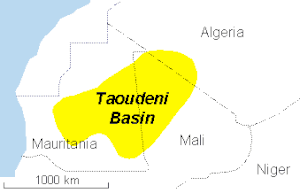

The Taoudeni Basin is a major Sedimentary basin in West Africa, named after the Taoudenni village in northern Mali. It covers large parts of the West African craton in Mauritania and Mali. It is of considerable interest due to its possible reserves of oil.[1] In addition to its economic importance, the basin contains scientifically important fossils from the Late Mesoproterozoic and Early Neoproterozoic eras, which correspond to a time interval known as the Boring Billion.[2]
Description
The Taoudeni is the largest sedimentary basin in Northwest Africa, formed during the Middle to Late Proterozoic. It continued to subside until the Middle Paleozoic, when Hercynian deformation and uplift occurred. It contains up to 6,000 metres (20,000 ft) of Late Precambrian and Paleozoic sediments. Exploratory drilling since the 1980s has found indications of petroleum in the Late Precambrian, Silurian and Late Devonian formations.[3]
Sediments are thicker in the western half of the basin.[4]
Petroleum geology

The government of Mali, one of the poorest countries in the world, is eager to create an oil industry.[5] Companies that have been exploring in the area include Baraka Petroleum, Sonatrach, Eni, Total S.A., Woodside and CNPC.[6]
However, the remote location and harsh environment of the Sahara Desert would make extraction expensive.[7]
References
- ^ Imrich Kusnir (1999). "Gold in Mali" (PDF). Acta Montanistica Slovaca. Retrieved 2009-03-14.
- ^ Beghin, Jérémie; Guilbaud, Romain; Poulton, Simon W.; Gueneli, Nur; Brocks, Jochen J.; Storme, Jean-Yves; Blanpied, Christian; Javaux, Emmanuelle J. (September 2017). "A palaeoecological model for the late Mesoproterozoic – early Neoproterozoic Atar/El Mreïti Group, Taoudeni Basin, Mauritania, northwestern Africa". Precambrian Research. 299: 1–14. doi:10.1016/j.precamres.2017.07.016. hdl:1885/139360.
- ^ Ibrahim Amadou. "Petroleum assessment of the intracratonic Taoudeni basin, Mali". CPRM. Retrieved 2009-03-14.
- ^ Wright, J.B. (1985). Geology and mineral resources of West Africa. London: Allen & Unwin. ISBN 0-04-556001-3.
- ^ a b "Mali – A Developing Oil and Gas IndustryA Industry" (PDF). The Corporate Council on Africa. 2006-12-01. Retrieved 2009-03-14.
- ^ "Taoudeni Basin, Onshore: Mali & Mauritania" (PDF). IHS. August 2007. Retrieved 2009-03-14.
- ^ "Taoudeni Basin Overview". Baraka Petroleum. Archived from the original on February 24, 2009. Retrieved 2009-03-14. Baraka Petroleum is bankrupt and the website does not exist any more. The exploration assets are now (2012) in the hands of Eni Group, Woodsite and Sonatrach.
External links
- "ICONS atlas: AFR - Taoudeni Basin". earthbyte.org. Retrieved 2009-03-14.
- v
- t
- e
Major African geological formations
- Major plates: African Plate
- Minor plates: Somali Plate
- Microplates: Lwandle Plate
- Madagascar Plate
- Rovuma Plate
- Seychelles Plate
- Victoria Microplate
- Aswa Dislocation
- Broodkop Shear Zone
- Central African Shear Zone
- Chuan Shear Zones
- Foumban Shear Zone
- Kandi Fault Zone
- Mwembeshi Shear Zone
- Todi Shear Zone
- Western Meseta Shear Zone
- Afar Triangle
- Anza trough
- Bahr el Arab rift
- Benue Trough
- Blue Nile rift
- East African Rift
- Gulf of Suez Rift
- Lamu Embayment
- Melut Basin
- Muglad Basin
- Red Sea Rift
- Sangha Aulacogen
- Atbara rift
- Urema Valley
- West and Central African Rift System
- White Nile rift
- Angola Basin
- Aoukar
- Blue Nile Basin
- Chad Basin
- Congo Basin
- Douala Basin
- El Djouf
- Karoo Basin
- Gabon Basin
- Iullemmeden Basin
- Kufra Basin
- Murzuq Basin
- Niger Delta Basin
- Ogaden Basin
- Orange River Basin
- Ouled Abdoun Basin
- Owambo Basin
- Reggane Basin
- Rio del Rey Basin
- Sirte Basin
- Somali Coastal Basin
- Taoudeni Basin
- Tanzania Coastal Basin
- Tindouf Basin
- Turkana Basin
- Aïr Mountains
- Atlas Mountains
- Aurès Mountains
- Bambouk Mountains
- Blue Mountains
- Cameroon line
- Central Pangean Mountains
- Chaillu Mountains
- Drakensberg
- Eastern Arc Mountains
- Eastern Rift mountains
- Ethiopian Highlands
- Great Escarpment
- Great Karas Mountains
- Guinea Highlands
- Hoggar Mountains
- Imatong Mountains
- Jebel Uweinat
- Loma Mountains
- Mandara Mountains
- Marrah Mountains
- Mitumba Mountains
- Nuba Mountains
- Rif Mountains
- Rwenzori Mountains
- Sankwala Mountains
- Serra da Leba
- Serra da Chela
- Teffedest Mountains
- Tibesti Mountains


