Tankersley Tavern
Historic commercial building in Virginia, United States
United States historic place
Tankersley Tavern | |
Virginia Landmarks Register | |
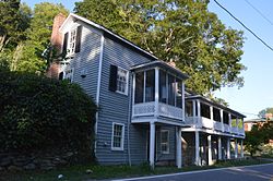 Front and western end | |
37°47′37.5″N 79°25′42″W / 37.793750°N 79.42833°W / 37.793750; -79.42833 | |
| Area | 2 acres (0.81 ha) |
|---|---|
| Built | c. 1835 (1835) |
| Built by | John and Samuel Jordan |
| NRHP reference No. | 88002179[1] |
| VLR No. | 081-0201 |
| Significant dates | |
| Added to NRHP | November 3, 1988 |
| Designated VLR | April 21, 1987[2] |
Tankersley Tavern, also known as Old Bridge, is a historic building located near Lexington, Rockbridge County, Virginia. It was built in three sections with the oldest dated to about 1835. It is a two-story, nine-bay, single pile, frame building with an exposed basement and a decorative two-level gallery on the front facade. Also on the property are the contributing washhouse/kitchen, three frame sheds and a stone abutment for a bridge. It was originally built as a toll house (toll gate) at the county end of the bridge crossing the Maury River from the Valley Turnpike into Lexington. It later housed a tavern, canal ticket office, general store, post office, and dwelling.[3]
It was listed on the National Register of Historic Places in 1988.[1]
References
- ^ a b "National Register Information System". National Register of Historic Places. National Park Service. July 9, 2010.
- ^ "Virginia Landmarks Register". Virginia Department of Historic Resources. Retrieved 5 June 2013.
- ^ Henry and Dolores Bausum and Pamela Simpson (February 1987). "National Register of Historic Places Inventory/Nomination: Tankersley Tavern" (PDF). Virginia Department of Historic Resources. and Accompanying photo
- v
- t
- e
by county
- Accomack
- Albemarle
- Alleghany
- Amelia
- Amherst
- Appomattox
- Arlington
- Augusta
- Bath
- Bedford
- Bland
- Botetourt
- Brunswick
- Buchanan
- Buckingham
- Campbell
- Caroline
- Carroll
- Charles City
- Charlotte
- Chesterfield
- Clarke
- Craig
- Culpeper
- Cumberland
- Dickenson
- Dinwiddie
- Essex
- Fairfax
- Fauquier
- Floyd
- Fluvanna
- Franklin
- Frederick
- Giles
- Gloucester
- Goochland
- Grayson
- Greene
- Greensville
- Halifax
- Hanover
- Henrico
- Henry
- Highland
- Isle Of Wight
- James City
- King and Queen
- King George
- King William
- Lancaster
- Lee
- Loudoun
- Louisa
- Lunenburg
- Madison
- Mathews
- Mecklenburg
- Middlesex
- Montgomery
- Nelson
- New Kent
- Northampton
- Northumberland
- Nottoway
- Orange
- Page
- Patrick
- Pittsylvania
- Powhatan
- Prince Edward
- Prince George
- Prince William
- Pulaski
- Rappahannock
- Richmond
- Roanoke
- Rockbridge
- Rockingham
- Russell
- Scott
- Shenandoah
- Smyth
- Southampton
- Spotsylvania
- Stafford
- Surry
- Sussex
- Tazewell
- Warren
- Washington
- Westmoreland
- Wise
- Wythe
- York

by city
- Alexandria
- Bristol
- Buena Vista
- Charlottesville
- Chesapeake
- Colonial Heights
- Covington
- Danville
- Emporia
- Fairfax
- Falls Church
- Franklin
- Fredericksburg
- Galax
- Hampton
- Harrisonburg
- Hopewell
- Lexington
- Lynchburg
- Manassas
- Manassas Park
- Martinsville
- Newport News
- Norfolk
- Norton
- Petersburg
- Poquoson (no listings)
- Portsmouth
- Radford
- Richmond
- Roanoke
- Salem
- Staunton
- Suffolk
- Virginia Beach
- Waynesboro
- Williamsburg
- Winchester
This article about a property in Rockbridge County, Virginia on the National Register of Historic Places is a stub. You can help Wikipedia by expanding it. |
- v
- t
- e


 Tankersley_Tavern