St. Clair Flats Front and Rear Range Light
Lighthouses in Michigan, United States
United States historic place
St. Clair Flats South Channel Range Lights | |
 Distant view of the lighthouse structures from Harsens Island in August 2022 | |
42°32′16.4″N 82°41′35.4″W / 42.537889°N 82.693167°W / 42.537889; -82.693167 | |
| Area | 1.5 acres (0.61 ha) |
|---|---|
| Built | 1859 |
| Architectural style | Conical lighthouse towers |
| NRHP reference No. | 90000853[1] |
| Added to NRHP | May 24, 1990 |
St. Clair Flats Front and Rear Range Light are two lighthouse structures situated off the southeastern tip of Harsens Island at Lake St. Clair.
History
By the late 1830s, it was recognized that constructing a shipping channel through the delta at the base of the Saint Clair River would be an aid in shipping. An 1842 survey by the Corps of Topographical Engineers recommended dredging the channel, but due in part to opposition by President James K. Polk, no federal funds were appropriated for a decade. In 1852, $20,000 was appropriated for improvements, but the money was quickly spent with little result. Meanwhile, the opening of the St. Mary's Falls Ship Canal in Sault Ste. Marie increased shipping through the Great Lakes, and left the Saint Clair delta as the major bottleneck to commerce through the lakes.[2]
In the early 1850s, numerous ship ran aground in the area, often blocking the entire canal and preventing access by other ships. Congress voted to appropriate further funds for improvements in 1854, but President Franklin Pierce vetoed the bills, as he did again in 1855 and 1856. By this time, the problem was severe, and in 1856, Congress overrode the presidential veto, and $45,000 was appropriated. From this funding, the canal dredging was completed, and two lighthouses and a nearby beacon constructed at the mouth of the channel. The two lighthouses were completed by 1859.[2]
In 1866, a further $60,000 was appropriated for improvements. However, the United States Army Corps of Engineers recommended abandoning the current channel (known as the "south channel") and opening up a new Saint Clair Flats channel. This new channel was opened in 1870, after which the older channel became less important, but still used.[2]
In 1875, the front light began to lean. It was dismantled and rebuilt using the original stone and timber crib.[3] By the early 20th century, the lights had become less useful, and in 1907 their use was discontinued.[2] However, in 1915, the lights were re-established, and continued in use until 1934, when they were again discontinued.[4]
Despite the 1875 reconstruction, the front light began to lean further due to erosion near the base of the light. In 1990, the base was reinforced by constructing a steel cell and filling it with limestone for temporary support. In the fall of 1996, a permanent seawall was completed around the front light island.[3]
The rear light was constructed with a large keeper's house on the island surrounding the light. The house was demolished in the early 1930s. However, later vandalism has played a part in the overall deterioration of the rear light, which is also in need of major foundation work. Current restoration has been taking place on the rear light.[3]
Description
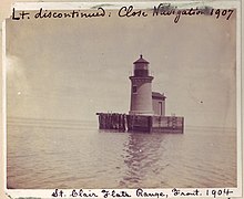

The two range light towers are located in shallow water nearly a mile from the nearest land. The front range light is the smaller of the two, It is a cylindrical yellow brick tower, measuring 17 feet tall and tapering from 11 feet in diameter at the base to 10 feet in diameter in diameter at the top. It sits on a stone base atop a submerged timber crib structure. A single square-head door in the base of the tower leads to a circular iron staircase inside, which goes up to the lantern. The light originally had a ten-sided, iron lantern and an ornamental iron railing. These have disappeared, and the navigational light is now fitted with a plastic lens.[2]
The larger, rear range light is also a cylindrical, brick structure atop a square stone pier. It is constructed of off-white brick, slightly lighter in hue than the yellow brick of the other light. The tower measures about 40 feet tall, and the original, ten-sided, iron lantern remains in place. A round-head entrance in the base and a circular iron staircase leads to the lantern platform.[2]
See also
References
- ^ "National Register Information System". National Register of Historic Places. National Park Service. July 9, 2010.
- ^ a b c d e f Robert O. Christensen (April 1990), National Register of Historic Places Registration Form: St. Clair Flats South Channel Range Lights
- ^ a b c "History". Save our South Channel Lights. Retrieved October 26, 2017.
- ^ "St. Clair Flats Range, MI". Lighthouse Friends. Retrieved October 27, 2017.
External links
![]() Media related to St. Clair Flats Front and Rear Range Light at Wikimedia Commons
Media related to St. Clair Flats Front and Rear Range Light at Wikimedia Commons
- Official Save Our South Channel Lights
- v
- t
- e
- Au Sable
- Big Bay Point
- Copper Harbor
- Copper Harbor Front Range
- Crisp Point
- Eagle Harbor
- Eagle Harbor Range Lights
- Eagle River
- Fourteen Mile Point
- Grand Island East Channel
- Grand Island Harbor Rear Range
- Grand Island North
- Grand Marais Range Lights
- Granite Island
- Gull Rock
- Huron Island
- Isle Royale
- Manitou Island
- Marquette Breakwater Outer
- Marquette Harbor
- Mendota (Bete Grise)
- Munising Front Range
- Munising Rear Range
- Ontonagon
- Ontonagon Harbor West Breakwater
- Portage River (Jacobsville)
- Passage Island
- Presque Isle Harbor Breakwater Light
- Rock Harbor
- Rock of Ages
- Sand Hills
- Sand Point Light (Baraga)
- St. Martin Island
- Stannard Rock
- Thunder Bay Island
- Whitefish Point

- Frying Pan Island
- Pipe Island
- Point Iroquois
- Round Island Light (St. Mary's River)
- Six Mile Point Range Rear
- Winter Point Range Front
- Keweenaw Waterway Lower Entrance
- Keweenaw Waterway Upper Entrance
- Portage Lake
- Rouleau Point Range Front and Rear Lights
- Beaver Island Harbor
- Beaver Island Head
- Big Sable Point
- Cedar River
- Charlevoix
- Charlevoix South Pier
- Frankfort
- Frankfort South Range
- Grand Haven North Pierhead
- Grand Haven South Pierhead Entrance
- Grand Haven South Pierhead Inner
- Grand Traverse
- Grays Reef
- Holland Harbor
- Ile Aux Galets
- Little Sable Point
- Little Traverse
- Ludington
- Manistee Pierhead
- Manning Memorial
- Mission Point
- Mission Point (1933)
- Muskegon Breakwater
- Muskegon Pier
- North Manitou Shoal
- Pentwater North Pierhead
- Pentwater South Pierhead
- Point Betsie
- Portage Lake
- South Fox Island
- South Haven
- South Manitou Island
- St. Joseph North Pier Inner
- St. Joseph North Pier Outer
- Waugoshance
- White River
- White Shoal
- Alpena
- Caseville Harbor
- Charity Island
- Cheboygan Crib
- Cheboygan River Front Range
- Detroit River
- Fort Gratiot
- Forty Mile Point
- Fourteen Foot Shoal
- Gibraltar
- Gravelly Shoal
- Harbor Beach
- Lake St. Clair
- Mariners Memorial
- Middle Island
- Miller Memorial
- New Presque Isle
- Old Presque Isle
- Peche Island Rear Range
- Poe Reef
- Pointe aux Barques
- Port Austin
- Port Sanilac
- Saginaw Bay
- Saginaw River Rear Range
- Spectacle Reef
- St. Clair Flats Front and Rear Range Light
- Sturgeon Point
- Tawas Point
- Thunder Bay Island
- Tri-Centennial Light of Detroit
- William Livingstone Memorial
- Windmill Point
- Au Sable North Pierhead
- Belle Isle
- Clinton River
- Ecorse
- Ecorse Range Rear
- Gibraltar
- Grassy Island
- Grassy Island North Channel Range Lights
- Grassy Island South Channel Range Lights
- Grosse Ile North Channel Range Lights
- Grosse Ile South Channel Range Lights
- Harwood Point East Range Front
- Kalamazoo River
- Mama Juda
- Mama Juda Range Front
- Manistee Main
- Middle Lake George
- Monroe Pier
- New Buffalo
- North Manitou Island
- Saginaw Bay
- Sand Beach North Entrance East
- Squaw Point
- St. Mary's River Lower Range Front
- Vidal Shoals Channel Range Front and Rear Lights
- Windmill Point Range Front and Rear Lights
- Lightship Huron
- List of lifesaving stations in Michigan
- Wixom Lake, Musselman Island lighthouse
| |
|---|---|
| Topics | |
| Lists by state |
|
| Lists by insular areas | |
| Lists by associated state | |
| Other areas | |
| Related | |
| |


