Soni, Nara
Village in Kansai, Japan
Soni  Flag  Seal | |
|---|---|
 Location of Soni in Nara Prefecture | |
| Symbols | |
| Bird | Japanese white-eye |
| Flower | Azalea |
| Tree | Cryptomeria |
Soni (曽爾村, Soni-mura) is a village located in Uda District, Nara Prefecture, Japan.
As of April 2017, the village has an estimated population of 1,528[1] and a density of 32 persons per km2. The total area is 47.84 km2.
Geography
The village of Soni is located in the northeastern portion of Nara Prefecture, in Uda District. It is situated in a cool climate, and most dwellings are located near the valley. Many mountains, including the Byōbu-iwa, are close to the valley. Also, the Shōrenji River flows through the village.[2]
Surrounding municipalities
- Nara Prefecture
- Uda
- Mitsue
- Higashiyoshino
- Mie Prefecture
- Nabari
- Tsu
Notable locations
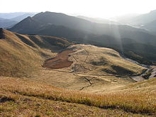
- Soni Plateau
- Koochi Valley
- Soni Plateau Hot Springs
- Byōbu-iwa
References
External links
 Media related to Soni, Nara at Wikimedia Commons
- Soni village Official Site (in Japanese)
 Geographic data related to Soni, Nara at OpenStreetMap
- v
- t
- e

Nara (capital)
- Nara

Authority control databases | |
|---|---|
| International |
|
| National |
|
 | This Nara Prefecture location article is a stub. You can help Wikipedia by expanding it. |
- v
- t
- e


