Sigma, Virginia
Unincorporated community in Virginia, United States
Sigma | |
|---|---|
Unincorporated community 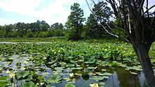 | |
36°43′55″N 75°59′10″W / 36.73194°N 75.98611°W / 36.73194; -75.98611 | |
| Country | United States |
| State | Virginia |
| Independent city | Virginia Beach |
| Time zone | UTC−5 (Eastern (EST)) |
| • Summer (DST) | UTC−4 (EDT) |
| GNIS feature ID | 1497153[1] |
Sigma is a small community near Sandbridge in the independent city of Virginia Beach, Virginia, United States. Sigma lies just south of Lago Mar on Ashville Bridge Creek along Sandbridge Road at its intersection with New Bridge Road.
The Back Bay National Wildlife Refuge has its administrative building on Sandbridge Road, and there is a large native garden of American Lotus across the street on a tributary of the Currituck Sound. Tabernacle United Methodist Church and Margie and Ray's Crabhouse are landmarks in the Sigma area.
Like much of the Southeastern United States, the Sigma area of Virginia Beach has a subtropical climate, characterized by short, relatively mild winters and long, hot and humid summers. Daytime high temperatures in July average around 90 °F (32 °C) and in January, daytime temperatures average around 52 °F (11 °C).[2]
| Climate data for Sigma, Virginia Beach, VA (1996–2023) | |||||||||||||
|---|---|---|---|---|---|---|---|---|---|---|---|---|---|
| Month | Jan | Feb | Mar | Apr | May | Jun | Jul | Aug | Sep | Oct | Nov | Dec | Year |
| Record high °F (°C) | 79 (26) | 85 (29) | 88 (31) | 94 (34) | 99 (37) | 103 (39) | 104 (40) | 102 (39) | 98 (37) | 96 (36) | 86 (30) | 82 (28) | 104 (40) |
| Mean daily maximum °F (°C) | 52 (11) | 55 (13) | 62 (17) | 71 (22) | 79 (26) | 86 (30) | 90 (32) | 88 (31) | 82 (28) | 73 (23) | 63 (17) | 56 (13) | 71 (22) |
| Mean daily minimum °F (°C) | 36 (2) | 38 (3) | 44 (7) | 52 (11) | 61 (16) | 70 (21) | 74 (23) | 73 (23) | 68 (20) | 58 (14) | 47 (8) | 40 (4) | 55 (13) |
| Record low °F (°C) | 12 (−11) | 11 (−12) | 22 (−6) | 33 (1) | 42 (6) | 51 (11) | 60 (16) | 60 (16) | 52 (11) | 37 (3) | 28 (−2) | 15 (−9) | 11 (−12) |
| Average precipitation inches (mm) | 3.56 (90.424) | 3.49 (88.646) | 3.59 (91.186) | 4.24 (107.696) | 4.35 (110.49) | 5.03 (127.762) | 6.64 (168.656) | 6.17 (156.718) | 6.38 (162.052) | 4.08 (103.632) | 3.75 (95.25) | 4.35 (110.49) | 55.63 (1,413.002) |
| Average snowfall inches (mm) | 2.06 (52.324) | 0.61 (15.494) | 0.06 (1.524) | 0.00 (0.1016) | 0.0 (0.0) | 0.0 (0.0) | 0.0 (0.0) | 0.0 (0.0) | 0.0 (0.0) | 0.0 (0.0) | 0.0 (0.0) | 0.53 (13.462) | 3.26 (82.9056) |
| Source: Sigma Weather | |||||||||||||
Gallery
-
 Lotus Garden Park in Sigma area of Virginia Beach
 -
 Ashville Bridge Creek in Sigma
 -
 Tabernacle Methodist on Sandbridge Rd near Sigma, VA
 -
 Back Bay NWR headquarters on Sandbridge Road near Sigma, VA


References
- v
- t
- e

- Naval Air Station Oceana
- Naval Amphibious Base Little Creek
- Camp Pendleton
- Fort Story
- Adam Keeling House
- Adam Thoroughgood House
- Association for Research and Enlightenment
- Atlantic Wildfowl Heritage Museum
- Cape Henry Light
- Cape Henry Memorial
- Cavalier Hotel
- Ferry Plantation House
- Francis Land House
- King Neptune statue
- Lynnhaven House
- Military Aviation Museum
- Norwegian Lady Statues
- Tidewater Arboretum
- Upper Wolfsnare
- Virginia Aquarium
- Virginia Beach Convention Center
- Virginia Beach Oceanfront
- Virginia Beach Sportsplex
- Virginia Beach Surf & Rescue Museum
- Virginia Museum of Contemporary Art
- Westin Virginia Beach Town Center
 | This City of Virginia Beach, Virginia state location article is a stub. You can help Wikipedia by expanding it. |
- v
- t
- e


