Rolpa District
District in Province No. 5, Nepal
District in Lumbini Province, Nepal
Rolpa District रोल्पा | |
|---|---|
District | |
 Apple orchard at Chalabang | |
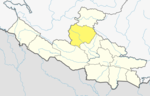
 Location of Rolpa (dark yellow) in Lumbini Province | |
| Country | Nepal |
| Province | Lumbini Province |
| Established | 13 April 1961 |
| Admin HQ. | Rolpa |
| Government | |
| • Type | Coordination committee |
| • Body | DCC, Rolpa |
| Area | |
| • Total | 1,879 km2 (725 sq mi) |
| Population (2015)[1] | |
| • Total | 221,178 |
| • Density | 120/km2 (300/sq mi) |
| Time zone | UTC+05:45 (NPT) |
| Main Language(s) | Nepali, Kham Magar, Newari, English |
| Website | ddcrolpa |
28°22′N 082°33′E / 28.367°N 82.550°E / 28.367; 82.550 (Rolpa District, Nepal)
Rolpa (Nepali: रोल्पा जिल्ला)Listenⓘ, is a "hill" district in Lumbini Province of Nepal. Rolpa district covers an area of 1,879 km2 (725 sq mi) with population (2011) of 221,177. Rolpa town is the district's administrative center.
The various grievances of Rolpa's population made the district ripe for revolt. It became a "Maoist Stronghold" of the Communist Party of Nepal.[2] In May 2002 a major battle between Maoist guerillas and the army was fought at Lisne Lekh near the Rolpa-Pyuthan border.
History
Before the 15th century, the region that is now Rolpa District was under the control of the Rukumkot Kingdom, ruled by the King of Rukum District. The area's political landscape changed when Tuthansen, the King of Salyankot, established a separate kingdom by annexing 18 villages from the Rukumkot Kingdom. This event marked the formation of the Gajulkot Kingdom. These villages were given to Tuthansen as part of a dowry arrangement by Jayant Berma, the then King of Rukumkot. The historical remnants of Gajulkot still exist in Rolpa District, serving as a testament to its rich history.
During the Rana regime in Nepal, the region that constitutes present-day Rolpa was not a separate district. Instead, it was divided between two larger administrative units: Pyuthan District and Salyan District. This arrangement persisted until 1962, when the government undertook administrative reforms to streamline the district divisions across the country. It was during this time that Rolpa was officially recognized and established as an independent district, carved out from portions of Pyuthan and Salyan Districts.
Rolpa's history is deeply intertwined with the broader regional politics of Nepal. Its establishment as a distinct district not only marked a reorganization of administrative boundaries but also paved the way for it to develop its own unique cultural and historical identity. The region holds significant historical value, with its ruins providing insight into the past kingdoms and territorial dynamics that shaped its early years. The influence of these historical shifts is still evident in Rolpa's cultural heritage and the collective memory of its people.
Administrative divisions

Rolpa district is divided into 10 local level bodies in which nine are rural municipalities and one is municipality:
- Rolpa Municipality
- Runtigadhi Rural Municipality
- Triveni Rural Municipality
- Sunilsmiriti Rural Municipality (previously: Suwarnawati Rural Municipality)
- Lungri Rural Municipality
- Sunchhahari Rural Municipality
- Thabang Rural Municipality
- Madi Rural Municipality
- Gangadev Rural Municipality (previously: Sukidaha Rural Municipality)
- Paribartan Rural Municipality (previously: Duikholi Rural Municipality)
Geography and climate
Rolpa is drained southward by the Madi Khola from a complex of 3,000 to 4,000 meter ridges about 50 kilometers south of the Dhaulagiri Himalaya. This mountainous barrier historically isolated Rolpa by encouraging travelers between India and Tibet to detour to follow easier routes to the east or west, while east–west travelers found easier routes to the north through Dhorpatan Valley, or to the south through Dang Valley or along the Mahabharat Range.
| Climate Zone[3] | Elevation Range | % of Area |
|---|---|---|
| Upper Tropical | 300 to 1,000 meters 1,000 to 3,300 ft. | 3.3% |
| Subtropical | 1,000 to 2,000 meters 3,300 to 6,600 ft. | 61.7% |
| Temperate | 2,000 to 3,000 meters 6,400 to 9,800 ft. | 31.4% |
| Subalpine | 3,000 to 4,000 meters 9,800 to 13,100 ft. | 3.6% |
Demographics
At the time of the 2011 Nepal census, Rolpa District had a population of 224,506.
As their first language, 86.1% spoke Nepali, 10.8% Magar, 2.6% Kham, 0.3% Gurung and 0.1% other languages.[4]
Ethnicity/caste: 43.4% were Magar, 33.9% Chhetri, 12.3% Kami, 3.6% Damai/Dholi, 2.3% Sanyasi/Dasnami, 1.1% Hill Brahmin, 0.9% Thakuri, 0.8% Sarki, 0.5% other Dalit, 0.5% Gurung, 0.2% Newar, 0.1% Badi, 0.1% Musalman and 0.2% others.[5]
Religion: 85.2% were Hindu, 11.7% Buddhist, 1.7% Christian, 0.7% Prakriti, 0.1% Muslim and 0.6% others.[6]
Literacy: 59.3% could read and write, 3.2% could only read and 37.5% could neither read nor write.[7]
Population by Census 1971-2021[8][9]

Historic, cultural, archeological sites
- Bhama Odar[10]
- Gari Lake, Jaulipokhari
- Bibang Daha, Gam
- Chaturbhuj Panchayan
- Baraha Khetra Badachaur
- Devi and Khadga Temple, Durga Bhawani, Durga Temple
- Gajulkot
- Jaljala, Jankot Jhankristhan
- Kalika Devi, Khungrikot, Kot Maula
- Pateswari Temple
- Shivalaya Mandir
- Kothi Vheer, Gam
- Murelle lake, Holleri
Health services
Rolpa is one of the most remote district in Nepal in terms of Health services some notable Health care centers being:
- Rolpa District Hospital[11] &
- Jeevan Anmol Hospital
- Jan Namuna Hospital[12]

Dashain Mela is celebrated in Rolpa Gajul kot which is located in Gajul Rolpa.

References
- ^ Statistics, Kathmandu, Nepal, Jan. 2014
- ^ "Archived copy" (PDF). Archived from the original (PDF) on 2012-02-21. Retrieved 2009-03-21.
{{cite web}}: CS1 maint: archived copy as title (link) - ^ The Map of Potential Vegetation of Nepal - a forestry/agroecological/biodiversity classification system (PDF), . Forest & Landscape Development and Environment Series 2-2005 and CFC-TIS Document Series No.110., 2005, ISBN 87-7903-210-9, retrieved Nov 22, 2013
- ^ NepalMap Language [1]
- ^ NepalMap Caste [2]
- ^ NepalMap Religion [3]
- ^ NepalMap Literacy [4]
- ^ #"Districts of Nepal". Statoids. Gwillim Law. Retrieved January 23, 2014.
- ^ #National Population and Housing Census 2011, Volume 3 (PDF). Kathmandu, Nepal: Government of Nepal, Central Bureau of Statistics. January 2014. Archived from the original (PDF) on May 25, 2013. Retrieved January 23, 2014.
- ^ Budha Magar, Jaya Prakash, ed. (1997). Inventory of heritage sites in Nepal. Singapore: IUCN Nepal. Archived from the original on 21 July 2011. Retrieved 11 November 2012.
- ^ "रोल्पा जि.स.स". ddcrolpa.gov.np. Retrieved 2018-01-28.
- ^ "Jan Namuna Hospital located at Ota : रोल्पा जि.स.स". ddcrolpa.gov.np. Retrieved 2018-01-28.
- "Districts of Nepal". Statoids.
External links
- [5] - Topographic maps of Rolpa District.
- v
- t
- e
Rolpa District
Headquarter: Rolpa
Rural units (VDCs)
- Aresh
- Bhawang
- Budagaun
- Dhawang
- Dubidanda
- Dubring
- Gam
- Gajul
- Gaurigaun
- Gharti Gaun
- Ghodagaun
- Gumchal
- Harjang
- Hwama
- Iriwang
- Jailwang
- Jaimakasala
- Jangkot
- Jauli Pokhari
- Jedwang
- Jhenam
- Jinawang
- Jungar
- Karchawang
- Kareti
- Khumel
- Khungri
- Kotgaun
- Kureli
- Masina
- Mijhing
- Mirul
- Nuwagaun
- Pachhawang
- Pakhapani
- Pang
- Phagam
- Rangkot
- Rangsi
- Rank
- Sakhi
- Seram
- Sirpa
- Siuri
- Talawang
- Tewang
- Thawang
- Uwa
- Wadachaur
- Wot

Wikimedia Commons has media related to Rolpa District.
Authority control databases | |
|---|---|
| International |
|
| National |
|


