Pindar River
River in Uttarakhand state of India
30°17′N 80°01′E / 30.283°N 80.017°E / 30.283; 80.017
• location
• coordinates
• elevation
The Pindar River is a river located in Uttarakhand, India. The Pindar originates from Pindari Glacier which is located in Bageshwar district of Kumaon region in Uttarakhand.[1] The source of this river, the Pindar glacier is located at an altitude of 3,820 m (12,530 ft). Pindar glacier has relatively easier access and has been documented well for its retreat over 100 years.[2] Pindar river mouth is located at Karnaprayag where it flows into Alaknanda River.
Gallery
-
 Origin from Pindari Glacier
 -
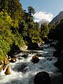 Pindari river from Dwali
 -
 Confluence of Alaknanda and Pindar from bottom
 -
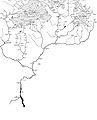 Pinder River (far right) in the map showing The Himalayan headwaters of the Ganges river in Uttarakhand


References
External links
- Pindar River on OpenStreetMap
Wikimedia Commons has media related to Pindar River.
- v
- t
- e
Hydrography of Uttarakhand
- Alaknanda
- Baur
- Bhagirathi
- Bhilangna
- Bindal
- Darma
- Dhauliganga
- Ganges
- Gaula
- Gomati
- Goriganga
- Jadhganga
- Jahnavi
- Kosi
- Lakshmanganga
- Mandakini
- Nandakini
- Nandhaur
- Nayar
- Pindar
- Pushpawati
- Ramganga
- Rishiganga
- Rispana
- Saraswati
- Sarju (Sarayu)
- Sharda
- Song
- Tons
- Vasukiganga
- Yamuna
Authority control databases | |
|---|---|
| International |
|
| National |
|
 | This article related to a location in the Indian state of Uttarakhand is a stub. You can help Wikipedia by expanding it. |
- v
- t
- e
This article related to a river in India is a stub. You can help Wikipedia by expanding it. |
- v
- t
- e


