Perkins Island Light
Lighthouse in Maine, US
Lighthouse
43°47′12.359″N 69°47′6.889″W / 43.78676639°N 69.78524694°W / 43.78676639; -69.78524694Perkins Island Light Station
Perkins Island Light is a lighthouse on the Kennebec River in Maine.[2][3] It was established in 1898, as part of a major upgrade of the river's lights — the Doubling Point Light and the separate Range Lights on the point, Perkins Island Light, and Squirrel Point Light were all built at the same time. It was listed on the National Register of Historic Places as Perkins Island Light Station in 1988.[1]
Description and history
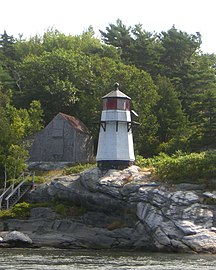
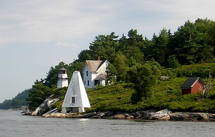
Perkins Island is a small, predominantly wooded island in the southern reaches of the Kennebec River, on the west side of Georgetown Island. It has a teardrop shape, oriented north–south, with the light station located at the westernmost part of the island. The station consists of a tower, keeper's house, barn, bell house, and oil house. The tower is a tapered octagonal wood-frame structure, with its exterior clad in wooden shingles. The lantern light stands 17 feet (5.2 m) above its base, in an octagonal lanternhouse with a surrounding exterior gallery.[4]
The keeper's house is a 2+1⁄2-story L-shaped wood-frame structure, with a cross-gabled roof and wooden shingle exterior. To its north stands a small wood-frame barn, also with a gabled roof and shingled exterior. To the south of the tower stands the oil house, a small brock gable-roofed structure. The bell tower is a pyramidal structure covered in shingles, standing near the shore south of the tower.[4]
The light station was authorized by Congress in 1895, following recommendations by the Lighthouse Board in 1892 that the Kennebec River's aids to navigation be improved. The tower, barn, and keeper's house were completed in 1898, the year the light went into service. The station also originally included a boathouse, which has not survived. The bell tower was added in 1902, and the oil house was added in 1906. The station was automated in 1959, and most of the buildings were transferred to the state in the 1960s.[4] The light continues to serve as an active aid to navigation.
-
 Closeup of lighthouse
 -
 Bell tower
 -
 L-R: Light, Bell Tower, Keepers' Quarters, Oil House


See also
References
- ^ a b "National Register Information System". National Register of Historic Places. National Park Service. March 13, 2009.
- ^ "Historic Light Station Information and Photography: Maine". United States Coast Guard Historian's Office. August 6, 2009. Archived from the original on May 1, 2017.
- ^ Light List, Volume I, Atlantic Coast, St. Croix River, Maine to Shrewsbury River, New Jersey (PDF). Light List. United States Coast Guard. 2009. p. 52.
- ^ a b c "NRHP nomination for Perkins Island Light". National Park Service. Retrieved May 19, 2016.
- v
- t
- e
Lighthouses of Maine
- Avery Rock Light
- Baker Island Light
- Bass Harbor Head Light
- Bear Island Light
- Blue Hill Bay Light
- Boon Island Light
- Browns Head Light
- Burnt Coat Harbor Light
- Burnt Island Light
- Cape Elizabeth Lights
- Cape Neddick Light
- Crabtree Ledge Light
- The Cuckolds Light
- Curtis Island Light
- Deer Isle Thorofare Light
- Dice Head Light
- Doubling Point Light
- Doubling Point Range Lights
- Eagle Island Light
- Egg Rock Light
- Fiddler's Reach Fog Signal
- Fort Point Light
- Franklin Island Light
- Goat Island Light
- Goose Rocks Light
- Great Duck Island Light
- Grindel Point Light
- Halfway Rock Light
- Hendricks Head Light
- Heron Neck Light
- Indian Island Light
- Isle au Haut Light
- Ladies Delight Light
- Libby Island Light
- Little River Light
- Lubec Channel Light
- Machias Seal Island*
- Marshall Point Light
- Matinicus Rock Light
- Monhegan Island Light
- Moose Peak Light
- Mount Desert Light
- Narraguagus Light
- Nash Island Light
- Owls Head Light
- Pemaquid Point Light
- Perkins Island Light
- Petit Manan Light
- Pond Island Light
- Portland Breakwater Light
- Portland Head Light
- Prospect Harbor Point Light
- Pumpkin Island Light
- Ram Island Light
- Ram Island Ledge Light
- Rockland Harbor Breakwater Light
- Saddleback Ledge Light
- Saint Croix River Light
- Seguin Light
- Spring Point Ledge Light
- Squirrel Point Light
- Tenants Harbor Light
- Two Bush Island Light
- West Quoddy Head Light
- Whaleback Light
- Whitehead Light
- Whitlocks Mill Light
- Winter Harbor Light
- Wood Island Light

* Disputed territory claimed by Maine but de facto controlled by Canada
| |
|---|---|
| Topics | |
| Lists by state |
|
| Lists by insular areas | |
| Lists by associated state | |
| Other areas | |
| Related | |
| |


| Authority control databases: Geographic |
|
|---|


