National Register of Historic Places listings in Washington County, Mississippi

This is a list of the National Register of Historic Places listings in Washington County, Mississippi.
This is intended to be a complete list of the properties and districts on the National Register of Historic Places in Washington County, Mississippi, United States. Latitude and longitude coordinates are provided for many National Register properties and districts; these locations may be seen together in a map.[1]
There are 25 properties and districts listed on the National Register in the county, including 1 National Historic Landmark. Another property was once listed but has been removed.
This National Park Service list is complete through NPS recent listings posted September 13, 2024.[2]
Map all coordinates using OpenStreetMap
Download coordinates as:
- KML
- GPX (all coordinates)
- GPX (primary coordinates)
- GPX (secondary coordinates)
Current listings
| [3] | Name on the Register[4] | Image | Date listed[5] | Location | City or town | Description |
|---|---|---|---|---|---|---|
| 1 | Arcola Mounds | Upload image | January 3, 1991 (#90002118) | Southwestern quarter of the southwestern quarter of Section 12, Township 16 North, Range 7 West[6] 33°14′40″N 90°52′55″W / 33.24444°N 90.88194°W / 33.24444; -90.88194 (Arcola Mounds) | Arcola | |
| 2 | Armitage Herschell Carousel | Upload image | March 28, 2012 (#12000155) | 323 Main St. 33°24′38″N 91°03′46″W / 33.410433°N 91.062719°W / 33.410433; -91.062719 (Armitage Herschell Carousel) | Greenville | |
| 3 | Bank of Washington | 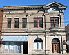 | July 16, 1987 (#87001209) | 120 S. Poplar St. 33°24′42″N 91°03′46″W / 33.411636°N 91.062724°W / 33.411636; -91.062724 (Bank of Washington) | Greenville | |
| 4 | Belmont Plantation |  | April 11, 1972 (#72000702) | Junction of Mississippi Highways 1 and 438 33°16′09″N 91°01′59″W / 33.269167°N 91.033056°W / 33.269167; -91.033056 (Belmont Plantation) | Wayside | |
| 5 | Doe's Eat Place | 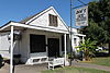 | April 11, 1972 (#12000156) | 502 Nelson St. 33°24′56″N 91°03′22″W / 33.415592°N 91.05603°W / 33.415592; -91.05603 (Doe's Eat Place) | Greenville | |
| 6 | Finlay House | 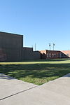 | April 27, 1982 (#82003119) | 137 N. Poplar St. 33°24′47″N 91°03′42″W / 33.413056°N 91.061667°W / 33.413056; -91.061667 (Finlay House) | Greenville | Demolished in 2009 |
| 7 | First National Bank of Greenville |  | January 30, 1978 (#78003195) | Main and S. Poplar Sts. 33°24′39″N 91°03′47″W / 33.410833°N 91.063056°W / 33.410833; -91.063056 (First National Bank of Greenville) | Greenville | |
| 8 | Gamwyn Park Historic District |  | August 11, 2004 (#04000820) | Bounded by Gamwyn Park Dr., N. Gamwyn Dr., E. Gamwyn Dr., S. Dr., and W. Gamwyn Dr. 33°23′22″N 91°02′51″W / 33.38942°N 91.047415°W / 33.38942; -91.047415 (Gamwyn Park Historic District) | Greenville | |
| 9 | Greenville Commercial Historic District |  | October 10, 1997 (#97000235) | Roughly Main St. from Walnut to Poplar Sts. 33°24′38″N 91°03′48″W / 33.410556°N 91.063333°W / 33.410556; -91.063333 (Greenville Commercial Historic District) | Greenville | |
| 10 | Griffin-Spragins House | Upload image | April 5, 1984 (#84002445) | Southwest of Greenville off U.S. Route 82 33°17′47″N 91°08′05″W / 33.296389°N 91.134722°W / 33.296389; -91.134722 (Griffin-Spragins House) | Refuge | |
| 11 | Hollandale Downtown Historic District | Upload image | January 15, 2014 (#13001084) | Washington St. from East to Morgan Aves. 33°10′07″N 90°51′17″W / 33.168617°N 90.85473°W / 33.168617; -90.85473 (Hollandale Downtown Historic District) | Hollandale | |
| 12 | Hollyknowe |  | October 10, 1985 (#85003004) | Southeast of the junction of U.S. Route 82 and County Road 299 33°24′02″N 90°49′59″W / 33.400556°N 90.833056°W / 33.400556; -90.833056 (Hollyknowe) | Leland | |
| 13 | Leavenworth-Wasson-Carroll House | 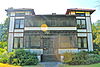 | July 23, 1980 (#80002306) | 623 S. Washington Ave. 33°23′55″N 91°03′08″W / 33.398611°N 91.052222°W / 33.398611; -91.052222 (Leavenworth-Wasson-Carroll House) | Greenville | |
| 14 | Leland Historic District |  | October 12, 2004 (#04001144) | Portions of N. and S. Broad, N. and S. Main, Deer Creek Dr., and 3rd St. 33°24′16″N 90°53′58″W / 33.404451°N 90.899359°W / 33.404451; -90.899359 (Leland Historic District) | Leland | |
| 15 | Linden | Upload image | November 12, 1982 (#82000581) | North of the Glen Allan junction of Mississippi Highways 69 and 97 33°02′56″N 91°01′50″W / 33.048889°N 91.030556°W / 33.048889; -91.030556 (Linden) | Glen Allan | |
| 16 | Live Oak Cemetery | Upload image | February 2, 2023 (#100008599) | 1447 South Main St. 33°22′58″N 91°03′15″W / 33.3828°N 91.0542°W / 33.3828; -91.0542 (Live Oak Cemetery) | Greenville | |
| 17 | Mount Holly |  | August 14, 1973 (#73001030) | Northwest of Foote off Mississippi Highway 1 33°05′42″N 91°02′12″W / 33.095°N 91.036667°W / 33.095; -91.036667 (Mount Holly) | Foote | Destroyed by fire June 2015 |
| 18 | Old Delta Democrat Times Building |  | March 25, 1982 (#82003120) | 201-203 Main St. 33°24′43″N 91°03′53″W / 33.411944°N 91.064722°W / 33.411944; -91.064722 (Old Delta Democrat Times Building) | Greenville | |
| 19 | U.S. Post Office |  | April 21, 1983 (#83000969) | 204 N. Broad St. 33°24′21″N 90°53′47″W / 33.405833°N 90.896389°W / 33.405833; -90.896389 (U.S. Post Office) | Leland | |
| 20 | Junius R. Ward House |  | April 28, 1975 (#75001060) | Old Mississippi Highway 1 33°06′13″N 91°02′50″W / 33.103611°N 91.047222°W / 33.103611; -91.047222 (Junius R. Ward House) | Erwin | |
| 21 | Washington Avenue-Main Street Historic District |  | May 3, 1984 (#84002446) | Roughly bounded by railroad tracks, Yerger, Arnold Ave., and Cherry St. 33°24′09″N 91°03′07″W / 33.4025°N 91.051944°W / 33.4025; -91.051944 (Washington Avenue-Main Street Historic District) | Greenville | |
| 22 | Washington County Courthouse |  | September 10, 2014 (#14000570) | 900 Washington Ave. 33°24′26″N 91°03′12″W / 33.4073°N 91.0532°W / 33.4073; -91.0532 (Washington County Courthouse) | Greenville | |
| 23 | Weinberg House | Upload image | September 28, 2017 (#100001683) | 639 Central St. 33°24′24″N 91°03′36″W / 33.406631°N 91.059904°W / 33.406631; -91.059904 (Weinberg House) | Greenville | |
| 24 | Wetherbee House |  | October 28, 1977 (#77000797) | 509 Washington Ave. 33°24′38″N 91°03′36″W / 33.410556°N 91.06°W / 33.410556; -91.06 (Wetherbee House) | Greenville | |
| 25 | Winterville site |  | August 17, 1973 (#73001031) | Along Mississippi Highway 1, approximately 6 miles (9.7 km) north of Greenville[7] 33°29′09″N 91°03′40″W / 33.485833°N 91.061111°W / 33.485833; -91.061111 (Winterville site) | Greenville |
Former listing
| [3] | Name on the Register | Image | Date listed | Date removed | Location | City or town | Description |
|---|---|---|---|---|---|---|---|
| 1 | Atterbury House | Upload image | November 24, 1982 (#82000580) | June 19, 1987 | 148 N. Broadway | Greenville | Demolished in December 1986[8] |
See also
Wikimedia Commons has media related to National Register of Historic Places in Washington County, Mississippi.
- List of National Historic Landmarks in Mississippi
- National Register of Historic Places listings in Mississippi
References
- ^ The latitude and longitude information provided in this table was derived originally from the National Register Information System, which has been found to be fairly accurate for about 99% of listings. Some locations in this table may have been corrected to current GPS standards.
- ^ National Park Service, United States Department of the Interior, "National Register of Historic Places: Weekly List Actions", retrieved September 13, 2024.
- ^ a b Numbers represent an alphabetical ordering by significant words. Various colorings, defined here, differentiate National Historic Landmarks and historic districts from other NRHP buildings, structures, sites or objects.
- ^ "National Register Information System". National Register of Historic Places. National Park Service. March 13, 2009.
- ^ The eight-digit number below each date is the number assigned to each location in the National Register Information System database, which can be viewed by clicking the number.
- ^ Phillips, Philip, et al. Archaeological Survey in the Lower Mississippi Alluvial Valley 1940-1947. Reprint ed. Tuscaloosa: U of Alabama P, 2003, 58.
- ^ Location derived from this National Park Service webpage; the NRIS lists the site as "Address Restricted"
- ^ MDAH
- v
- t
- e
by county
- Adams
- Alcorn
- Amite
- Attala
- Benton
- Bolivar
- Calhoun
- Carroll
- Chickasaw
- Choctaw
- Claiborne
- Clarke
- Clay
- Coahoma
- Copiah
- Covington
- DeSoto
- Forrest
- Franklin
- George
- Greene
- Grenada
- Hancock
- Harrison
- Hinds
- Holmes
- Humphreys
- Issaquena
- Itawamba
- Jackson
- Jasper
- Jefferson
- Jefferson Davis
- Jones
- Kemper
- Lafayette
- Lamar
- Lauderdale
- Lawrence
- Leake
- Lee
- Leflore
- Lincoln
- Lowndes
- Madison
- Marion
- Marshall
- Monroe
- Montgomery
- Neshoba
- Newton
- Noxubee
- Oktibbeha
- Panola
- Pearl River
- Perry
- Pike
- Pontotoc
- Prentiss
- Quitman
- Rankin
- Scott
- Sharkey
- Simpson
- Smith
- Stone
- Sunflower
- Tallahatchie
- Tate
- Tippah
- Tishomingo
- Tunica
- Union
- Walthall
- Warren
- Washington
- Wayne
- Webster
- Wilkinson
- Winston
- Yalobusha
- Yazoo

Municipalities and communities of Washington County, Mississippi, United States | ||
|---|---|---|
County seat: Greenville | ||
| Cities |  | |
| Towns | ||
| CDPs | ||
| Other communities | ||
| Ghost towns | ||
| ||


