National Register of Historic Places listings in Warren County, New Jersey
List of the National Register of Historic Places listings in Warren County, New Jersey
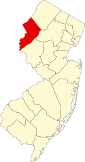
| Atlantic – Bergen (Closter, Franklin Lakes, Ridgewood, Saddle River, Wyckoff) – Burlington – Camden – Cape May – Cumberland – Essex – Gloucester – Hudson – Hunterdon – Mercer – Middlesex – Monmouth – Morris – Ocean – Passaic – Salem – Somerset – Sussex – Union – Warren |
Map all coordinates using OpenStreetMap
Download coordinates as:
- KML
- GPX (all coordinates)
- GPX (primary coordinates)
- GPX (secondary coordinates)
This is intended to be a complete list of properties and districts listed on the National Register of Historic Places in Warren County, New Jersey. Latitude and longitude coordinates of the sites listed on this page may be displayed in an online map.[1]
This National Park Service list is complete through NPS recent listings posted September 13, 2024.[2]
| [3] | Name on the Register[4] | Image | Date listed[5] | Location | City or town | Description |
|---|---|---|---|---|---|---|
| 1 | Allamuchy Freight House | 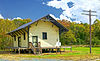 | September 23, 2002 (#02001056) | Rte. 612, 800 feet south of intersection with Long Bridge Road. 40°55′55″N 74°49′13″W / 40.932012°N 74.82021°W / 40.932012; -74.82021 (Allamuchy Freight House) | Allamuchy | |
| 2 | Jacob C. Allen House |  | August 24, 2005 (#05000911) | 206 W. Moore Street 40°51′07″N 74°49′50″W / 40.851944°N 74.830694°W / 40.851944; -74.830694 (Jacob C. Allen House) | Hackettstown | |
| 3 | Asbury Historic District |  | March 19, 1993 (#93000132) | County Routes 632 and 643, Maple Avenue, Kitchen Road, and School Street 40°41′53″N 75°00′50″W / 40.698056°N 75.013889°W / 40.698056; -75.013889 (Asbury Historic District) | Asbury | Extends into Bethlehem Township, Hunterdon County |
| 4 | Beattystown Historic District | 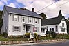 | September 28, 1990 (#90001449) | Junction of NJ 57 and Kings Highway 40°48′49″N 74°50′34″W / 40.813611°N 74.842778°W / 40.813611; -74.842778 (Beattystown Historic District) | Beattystown | |
| 5 | Belvidere Historic District | 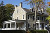 | October 3, 1980 (#80002525) | Market and Race streets; Greenwich and Mansfield avenues; and the Pequest River 40°49′45″N 75°04′37″W / 40.829167°N 75.076944°W / 40.829167; -75.076944 (Belvidere Historic District) | Belvidere | Includes Warren County Courthouse |
| 6 | Blair Academy | 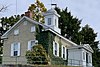 | January 24, 1992 (#89001944) | NJ Route 94 40°59′06″N 74°57′50″W / 40.985000°N 74.963889°W / 40.985000; -74.963889 (Blair Academy) | Blairstown | Historically known as Blair Presbyterial Academy |
| 7 | Blairstown Historic District |  | February 16, 2007 (#07000046) | Main Street, East Avenue, Douglas Street, Water Street, Blair Place 40°58′59″N 74°57′35″W / 40.983056°N 74.959722°W / 40.983056; -74.959722 (Blairstown Historic District) | Blairstown | |
| 8 | Bowerstown Historic District | 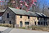 | May 10, 1996 (#96000537) | Roughly bounded by Bowerstown, Plane Hill, Lannings Trail and Mine Hill roads 40°46′22″N 74°59′54″W / 40.772778°N 74.998333°W / 40.772778; -74.998333 (Bowerstown Historic District) | Washington Township | |
| 9 | Centenary Collegiate Institute |  | June 13, 1997 (#97000564) | 400 Jefferson Street 40°50′57″N 74°49′57″W / 40.849167°N 74.832500°W / 40.849167; -74.832500 (Centenary Collegiate Institute) | Hackettstown | |
| 10 | Delaware Historic District | 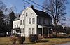 | March 20, 2003 (#03000128) | Ann, Clinton, Charles, and Valley Streets, Delaware Road, NJ 46 and Ferry Lane 40°53′44″N 75°03′51″W / 40.895556°N 75.064167°W / 40.895556; -75.064167 (Delaware Historic District) | Delaware | |
| 11 | Fairview Schoolhouse | 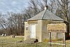 | August 12, 1977 (#77000916) | Fairview Cemetery on Dean Road 40°55′17″N 75°00′52″W / 40.921389°N 75.014444°W / 40.921389; -75.014444 (Fairview Schoolhouse) | Knowlton Township | |
| 12 | Finesville–Seigletown Historic District |  | November 10, 2010 (#10000892) | County Route 627; Mountain, Musconetcong, Mount Joy and Bellis roads 40°36′32″N 75°10′04″W / 40.608889°N 75.167778°W / 40.608889; -75.167778 (Finesville–Seigletown Historic District) | Finesville | Includes Seigle Homestead. Extends into Holland Township, Hunterdon County |
| 13 | First Methodist Episcopal Church | 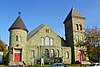 | July 17, 2017 (#100001322) | 116 E. Washington Ave. 40°45′34″N 74°58′36″W / 40.759362°N 74.976767°W / 40.759362; -74.976767 (First Methodist Episcopal Church) | Washington | Known as United Methodist Church |
| 14 | Great Meadows Railroad Station |  | March 23, 1989 (#89000229) | Cemetery Rd. 40°53′01″N 74°54′29″W / 40.883611°N 74.908056°W / 40.883611; -74.908056 (Great Meadows Railroad Station) | Great Meadows | |
| 15 | Hixson–Mixsell House | 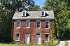 | May 12, 2014 (#14000204) | 157 County Route 519, Springtown 40°38′52″N 75°08′54″W / 40.647778°N 75.148333°W / 40.647778; -75.148333 (Hixson–Mixsell House) | Pohatcong Township | Also known as Springtown Stagecoach Inn |
| 16 | Hixson–Skinner Mill Complex | 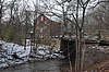 | December 2, 1982 (#82001047) | Still Valley Road 40°39′16″N 75°08′10″W / 40.654444°N 75.136111°W / 40.654444; -75.136111 (Hixson–Skinner Mill Complex) | Pohatcong Township | Also known as Cole's Grist Mill Complex |
| 17 | Hope Historic District |  | July 20, 1973 (#73001138) | Roughly bounded by Beaver Brook, Washington Street, and Brookaloo Swamp 40°54′42″N 74°58′13″W / 40.911667°N 74.970278°W / 40.911667; -74.970278 (Hope Historic District) | Hope | Includes St. Luke's Episcopal Church |
| 18 | George Hunt House |  | September 12, 1979 (#79001531) | SW of Alpha at 135 Warren Glen Road 40°35′54″N 75°10′57″W / 40.598333°N 75.1825°W / 40.598333; -75.1825 (George Hunt House) | Pohatcong Township | |
| 19 | Imlaydale Historic District |  | March 27, 1991 (#91000306) | Imlaydale Road and surrounding land between NJ 31 and the Musconetcong River, Washington and Lebanon Townships 40°42′47″N 74°58′07″W / 40.713056°N 74.968611°W / 40.713056; -74.968611 (Imlaydale Historic District) | Washington Township | Extends into Lebanon Township, Hunterdon County |
| 20 | Johnsonburg Historic District | 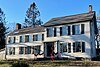 | October 15, 1992 (#92001386) | NJ 519 and 661 and adjacent parts of Mott and Allamuchy Roads, Johnsonburg 40°57′59″N 74°52′36″W / 40.966389°N 74.876667°W / 40.966389; -74.876667 (Johnsonburg Historic District) | Frelinghuysen Township | |
| 21 | Kennedy House and Mill | 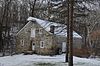 | May 16, 1996 (#96000552) | 306 NJ 173, Kennedy Mills 40°39′41″N 75°06′56″W / 40.661389°N 75.115556°W / 40.661389; -75.115556 (Kennedy House and Mill) | Greenwich Township | |
| 22 | Lander–Stewart Mansion and Stites Building |  | June 26, 2008 (#08000561) | 102–104 South Main Street 40°41′23″N 75°12′04″W / 40.689722°N 75.201111°W / 40.689722; -75.201111 (Lander–Stewart Mansion and Stites Building) | Phillipsburg | |
| 23 | Miller Farmstead |  | September 11, 1989 (#88002118) | NJ 57 40°47′09″N 74°53′42″W / 40.785833°N 74.895000°W / 40.785833; -74.895000 (Miller Farmstead) | Mansfield Township | Extends into Lebanon Township, Hunterdon County |
| 24 | Morris Canal |  | October 1, 1974 (#74002228) | Irregular line beginning at Phillipsburg and ending at Jersey City 40°41′08″N 75°09′49″W / 40.685556°N 75.163611°W / 40.685556; -75.163611 (Morris Canal) | Not Applicable | Delaware River Portal, the western terminus, is in Phillispburg |
| 25 | Mount Bethel Methodist Church |  | February 29, 1980 (#80002526) | W of Hackettstown at intersection of Mount Bethel Rd. and Snyder Rd. 40°49′32″N 74°54′07″W / 40.825556°N 74.901944°W / 40.825556; -74.901944 (Mount Bethel Methodist Church) | Mansfield | |
| 26 | New Hampton Pony Pratt Truss Bridge |  | July 26, 1977 (#77000877) | Rymon Road over the Musconetcong River 40°43′14″N 74°57′49″W / 40.720556°N 74.963611°W / 40.720556; -74.963611 (New Hampton Pony Pratt Truss Bridge) | Washington Township | Includes Hunterdon County, Shoddy Mill Road, New Hampton |
| 27 | Old Mine Road Historic District |  | December 3, 1980 (#80000410) | NJ 521, Delaware, Old Mine, and River Roads 41°05′20″N 74°57′40″W / 41.088889°N 74.961111°W / 41.088889; -74.961111 (Old Mine Road Historic District) | Not Applicable | Extends into Sussex County |
| 28 | Oxford Furnace | 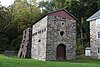 | July 6, 1977 (#77000919) | Belvidere and Washington Avenues 40°48′14″N 74°59′52″W / 40.803889°N 74.997778°W / 40.803889; -74.997778 (Oxford Furnace) | Oxford | |
| 29 | Oxford Industrial Historic District |  | August 27, 1992 (#91001471) | NJ Route 31; Belvidere, Buckley, and Washington avenues; Jonestown and Mine Hill roads; Academy and Church streets, and vicinity 40°47′55″N 74°59′42″W / 40.798611°N 74.995°W / 40.798611; -74.995 (Oxford Industrial Historic District) | Oxford Township | Includes Oxford Furnace and Shippen Manor |
| 30 | Perry–Petty Farmstead |  | April 9, 1999 (#99000392) | 882 Jackson Valley Road 40°48′09″N 74°56′20″W / 40.802389°N 74.939000°W / 40.802389; -74.939000 (Perry–Petty Farmstead) | Mansfield Township | |
| 31 | Phillipsburg Commercial Historic District |  | October 8, 2008 (#08000973) | 29-169 S. Main St., 60-178 S. Main St., 3 Hudson St., 9 and 12-30 Morris St./Main St., 7-11, 17, and 21-27 Union Sq. 40°41′29″N 75°12′08″W / 40.691389°N 75.202222°W / 40.691389; -75.202222 (Phillipsburg Commercial Historic District) | Phillipsburg | Includes Lander–Stewart Mansion and Stites Building |
| 32 | Pleasant Valley Historic District | 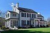 | February 17, 1994 (#94000013) | Area surrounding Mill Pond Road 40°44′57″N 75°00′21″W / 40.749167°N 75.005833°W / 40.749167; -75.005833 (Pleasant Valley Historic District) | Washington Township | |
| 33 | Port Colden Historic District | 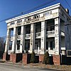 | January 21, 1999 (#98001639) | Roughly along Port Colden Road, Lock Street, NJ 57, and Morris Canal Terrace, Port Colden 40°45′55″N 74°57′19″W / 40.765278°N 74.955278°W / 40.765278; -74.955278 (Port Colden Historic District) | Washington Township | , |
| 34 | Port Murray Historic District |  | June 7, 1996 (#96000658) | Roughly, Port Murray Road from Cherry Tree Bend Road to Hoffman Road, Port Murray 40°47′31″N 74°54′51″W / 40.791944°N 74.914167°W / 40.791944; -74.914167 (Port Murray Historic District) | Mansfield Township | |
| 35 | Ramsaysburg Homestead | 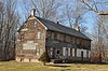 | October 27, 2004 (#04001194) | U.S. Route 46 40°52′40″N 75°03′21″W / 40.877778°N 75.055833°W / 40.877778; -75.055833 (Ramsaysburg Homestead) | Knowlton Township | |
| 36 | John Richey House |  | March 20, 2002 (#02000216) | 6 Schnetzer Lane 40°43′05″N 75°00′03″W / 40.718139°N 75.000944°W / 40.718139; -75.000944 (John Richey House) | Franklin Township | |
| 37 | John Roseberry Homestead |  | April 3, 1973 (#73001139) | 540 Warren St. 40°41′19″N 75°10′54″W / 40.688611°N 75.181667°W / 40.688611; -75.181667 (John Roseberry Homestead) | Phillipsburg | |
| 38 | Rutherfurd Hall |  | April 24, 2013 (#11000592) | County Route 517 and Interstate Route 80 40°54′52″N 74°48′48″W / 40.914444°N 74.813333°W / 40.914444; -74.813333 (Rutherfurd Hall) | Allamuchy Township | |
| 39 | St. James Lutheran Church and Cemetery | 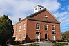 | October 24, 2016 (#16000737) | 1213 U.S. Route 22 40°40′49″N 75°08′45″W / 40.680373°N 75.145768°W / 40.680373; -75.145768 (St. James Lutheran Church and Cemetery) | Pohatcong Township | Cemetery is in Greenwich Township |
| 40 | Seigle Homestead |  | November 7, 1977 (#77000918) | Riegelsville-Warren Glen Road 40°36′43″N 75°09′54″W / 40.611944°N 75.165000°W / 40.611944; -75.165000 (Seigle Homestead) | Finesville | |
| 41 | Shippen Manor | 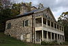 | December 20, 1984 (#84000517) | Belvidere Rd. 40°48′19″N 74°59′51″W / 40.805278°N 74.9975°W / 40.805278; -74.9975 (Shippen Manor) | Oxford | |
| 42 | Spring Valley Christian Church Site |  | September 18, 1997 (#97001147) | Spring Valley Rd., 0.5 mi (0.80 km). E of Hardwick Center 41°00′20″N 74°56′23″W / 41.005556°N 74.939722°W / 41.005556; -74.939722 (Spring Valley Christian Church Site) | Hardwick Township | |
| 43 | St. Luke's Episcopal Church |  | March 16, 2007 (#07000151) | 346 High Street 40°54′38″N 74°58′08″W / 40.910417°N 74.968778°W / 40.910417; -74.968778 (St. Luke's Episcopal Church) | Hope | |
| 44 | Van Nest–Hoff–Vannatta Farmstead |  | December 28, 2005 (#05001484) | Cty Rd. 519 40°45′47″N 75°07′49″W / 40.763056°N 75.130278°W / 40.763056; -75.130278 (Van Nest–Hoff–Vannatta Farmstead) | Harmony | |
| 45 | Vass Farmstead | 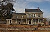 | September 17, 1999 (#99001170) | 109 Stillwater Road 41°00′10″N 74°54′58″W / 41.002778°N 74.916111°W / 41.002778; -74.916111 (Vass Farmstead) | Hardwick Township | |
| 46 | Warrington Stone Bridge |  | December 16, 1977 (#77000917) | Brugler Road over Paulins Kill, Warrington 40°56′09″N 75°04′17″W / 40.935833°N 75.07125°W / 40.935833; -75.07125 (Warrington Stone Bridge) | Knowlton Township | |
| 47 | Washington Railroad Station |  | July 3, 1979 (#79001532) | Railroad Ave. 40°45′30″N 74°58′06″W / 40.758333°N 74.968333°W / 40.758333; -74.968333 (Washington Railroad Station) | Washington |
References
Wikimedia Commons has media related to National Register of Historic Places in Warren County, New Jersey.
- ^ The latitude and longitude information provided in this table was derived originally from the National Register Information System, which has been found to be fairly accurate for about 99% of listings. Some locations in this table may have been corrected to current GPS standards.
- ^ National Park Service, United States Department of the Interior, "National Register of Historic Places: Weekly List Actions", retrieved September 13, 2024.
- ^ Numbers represent an alphabetical ordering by significant words. Various colorings, defined here, differentiate National Historic Landmarks and historic districts from other NRHP buildings, structures, sites or objects.
- ^ "National Register Information System". National Register of Historic Places. National Park Service. April 24, 2008.
- ^ The eight-digit number below each date is the number assigned to each location in the National Register Information System database, which can be viewed by clicking the number.
- v
- t
- e

 Category
 NRHP Portal
- New Jersey Portal


Municipalities and communities of Warren County, New Jersey, United States | ||
|---|---|---|
County seat: Belvidere | ||
| Boroughs |  | |
| Towns | ||
| Townships | ||
| CDPs |
| |
| Other unincorporated communities | ||
| ||


 National_Register_of_Historic_Places_listings_in_Warren_County,_New_Jersey