National Register of Historic Places listings in Pueblo County, Colorado
List of National Register of Historic Places in Pueblo County, Colorado, United States

This is a list of the National Register of Historic Places listings in Pueblo County, Colorado, USA.
It is intended to be a complete list of the properties and districts on the National Register of Historic Places in Pueblo County, Colorado. The locations of National Register properties and districts for which the latitude and longitude coordinates are included below, may be seen in a map.[1]
There are 68 properties and districts listed on the National Register in the county, one of which is also designated a National Historic Landmark. Another six properties was once listed but has been removed.
This National Park Service list is complete through NPS recent listings posted June 28, 2024.[2]
- v
- t
- e
Properties on the National Register of Historic Places in Colorado by county
- Adams
- Alamosa
- Arapahoe
- Archuleta
- Baca
- Bent
- Boulder
- Broomfield
- Chaffee
- Cheyenne
- Clear Creek
- Conejos
- Costilla
- Crowley
- Custer
- Delta
- Denver
- Dolores
- Douglas
- Eagle
- El Paso
- Elbert
- Fremont
- Garfield
- Gilpin
- Grand
- Gunnison
- Hinsdale
- Huerfano
- Jackson
- Jefferson
- Kiowa
- Kit Carson
- La Plata
- Lake
- Larimer
- Las Animas
- Lincoln
- Logan
- Mesa
- Mineral
- Moffat
- Montezuma
- Montrose
- Morgan
- Otero
- Ouray
- Park
- Phillips
- Pitkin
- Prowers
- Pueblo
- Rio Blanco
- Rio Grande
- Routt
- Saguache
- San Juan
- San Miguel
- Sedgwick
- Summit
- Teller
- Washington
- Weld
- Yuma

Map all coordinates using OpenStreetMap
Download coordinates as:
- KML
- GPX (all coordinates)
- GPX (primary coordinates)
- GPX (secondary coordinates)
Current listings
| [3] | Name on the Register[4] | Image | Date listed[5] | Location | City or town | Description |
|---|---|---|---|---|---|---|
| 1 | Barndollar-Gann House |  | November 7, 1985 (#85002761) | 1906 Court St. 38°17′06″N 104°36′34″W / 38.285°N 104.6094°W / 38.285; -104.6094 (Barndollar-Gann House) | Pueblo | |
| 2 | Baxter House |  | February 17, 1978 (#78000876) | 325 W. 15th St. 38°16′51″N 104°36′40″W / 38.2808°N 104.6111°W / 38.2808; -104.6111 (Baxter House) | Pueblo | |
| 3 | Allen J. Beaumont House |  | August 18, 1983 (#83001328) | 425 W. 15th St. 38°16′51″N 104°36′45″W / 38.2808°N 104.6125°W / 38.2808; -104.6125 (Allen J. Beaumont House) | Pueblo | |
| 4 | Dr. John A. Black House Complex | 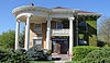 | November 7, 1985 (#85002760) | 102 W. Pitkin Ave. 38°15′24″N 104°37′29″W / 38.2567°N 104.6247°W / 38.2567; -104.6247 (Dr. John A. Black House Complex) | Pueblo | |
| 5 | Boone Santa Fe Railroad Depot |  | June 27, 1997 (#97000618) | 100 Baker Ave. 38°14′55″N 104°15′23″W / 38.2486°N 104.2564°W / 38.2486; -104.2564 (Boone Santa Fe Railroad Depot) | Boone | |
| 6 | Bowen Mansion |  | January 9, 1978 (#78000877) | 229 W. 12th St. 38°16′42″N 104°36′34″W / 38.2783°N 104.6094°W / 38.2783; -104.6094 (Bowen Mansion) | Pueblo | |
| 7 | Butler House | Upload image | August 16, 1984 (#84000880) | 6916 Broadacre Rd. 38°00′43″N 104°27′17″W / 38.01204°N 104.45480°W / 38.01204; -104.45480 (Butler House) | Avondale | Ranch complex on Huerfano River dating from 1865 or 1880. |
| 8 | James N. Carlile House | 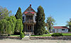 | February 8, 1985 (#85000297) | 44 Carlile Pl. 38°16′11″N 104°37′43″W / 38.2697°N 104.6286°W / 38.2697; -104.6286 (James N. Carlile House) | Pueblo | |
| 9 | Central High School | 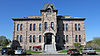 | November 14, 1979 (#79000619) | 431 E. Pitkin Ave. 38°15′11″N 104°37′13″W / 38.2531°N 104.6203°W / 38.2531; -104.6203 (Central High School) | Pueblo | |
| 10 | Central Junior High School-Keating Junior High School |  | December 7, 2020 (#100005855) | 215 East Orman Ave. 38°15′12″N 104°37′32″W / 38.2533°N 104.6256°W / 38.2533; -104.6256 (Central Junior High School-Keating Junior High School) | Pueblo | |
| 11 | City Park Carousel |  | April 21, 1983 (#83001297) | City Park 38°15′44″N 104°39′17″W / 38.2622°N 104.6547°W / 38.2622; -104.6547 (City Park Carousel) | Pueblo | |
| 12 | Colorado Building | 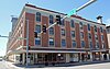 | April 17, 1992 (#92000315) | 401-411 N. Main St. 38°16′15″N 104°36′30″W / 38.2708°N 104.6083°W / 38.2708; -104.6083 (Colorado Building) | Pueblo | |
| 13 | Colorado State Hospital Superintendent's House |  | September 26, 1985 (#85002563) | 13th and Francisco Sts. 38°16′50″N 104°37′26″W / 38.2806°N 104.6239°W / 38.2806; -104.6239 (Colorado State Hospital Superintendent's House) | Pueblo | |
| 14 | Coronado Lodge |  | March 30, 2020 (#100005146) | 2130 Lake Ave. 38°13′49″N 104°37′29″W / 38.2304°N 104.6248°W / 38.2304; -104.6248 (Coronado Lodge) | Pueblo | |
| 15 | Doyle Settlement |  | April 10, 1980 (#80000922) | Southeast of Pueblo on Doyle Rd. 38°03′30″N 104°24′51″W / 38.0583°N 104.4142°W / 38.0583; -104.4142 (Doyle Settlement) | Pueblo | |
| 16 | Nathaniel W. Duke House |  | February 8, 1985 (#85000229) | 1409 Craig St. 38°16′48″N 104°37′05″W / 38.28013°N 104.61813°W / 38.28013; -104.61813 (Nathaniel W. Duke House) | Pueblo | Queen Anne house of pioneer-era groceries businessman |
| 17 | Edison School |  | June 19, 1985 (#85001330) | 900 W. Mesa 38°14′48″N 104°36′06″W / 38.2467°N 104.6017°W / 38.2467; -104.6017 (Edison School) | Pueblo | |
| 18 | El Pueblo | 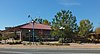 | February 16, 1996 (#96000039) | Junction of 1st St. and Union Ave. 38°16′03″N 104°36′35″W / 38.2675°N 104.6097°W / 38.2675; -104.6097 (El Pueblo) | Pueblo | |
| 19 | First Congregational Church |  | February 8, 1985 (#85000230) | 225 W. Evans 38°15′37″N 104°37′57″W / 38.2603°N 104.6325°W / 38.2603; -104.6325 (First Congregational Church) | Pueblo | |
| 20 | First Methodist Episcopal Church | 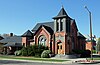 | November 14, 1979 (#79000620) | 400 Broadway St. 38°15′19″N 104°37′23″W / 38.2553°N 104.6231°W / 38.2553; -104.6231 (First Methodist Episcopal Church) | Pueblo | |
| 21 | First Methodist Episcopal Church |  | April 16, 2012 (#12000201) | 310 W. 11th St. 38°16′37″N 104°36′39″W / 38.2769°N 104.6107°W / 38.2769; -104.6107 (First Methodist Episcopal Church) | Pueblo | |
| 22 | Fitch Terrace |  | October 2, 1986 (#86002809) | 401, 403, 405, 407, 409, and 411 W. 11th St. 38°16′39″N 104°36′42″W / 38.2775°N 104.6117°W / 38.2775; -104.6117 (Fitch Terrace) | Pueblo | |
| 23 | R.T. Frazier House |  | June 19, 1985 (#85001329) | 2121 N. Elizabeth St. 38°17′18″N 104°36′55″W / 38.28834°N 104.61533°W / 38.28834; -104.61533 (R.T. Frazier House) | Pueblo | Craftsman-style house built in 1915 for leading saddlemaker R.T. Frazier |
| 24 | Galligan House |  | June 3, 1982 (#82002311) | 501 Colorado Ave. 38°15′19″N 104°37′34″W / 38.2553°N 104.6261°W / 38.2553; -104.6261 (Galligan House) | Pueblo | |
| 25 | Gast Mansion |  | June 3, 1982 (#82002312) | 1801 Greenwood St. 38°17′02″N 104°36′47″W / 38.283889°N 104.613056°W / 38.283889; -104.613056 (Gast Mansion) | Pueblo | |
| 26 | Goodnight Barn |  | July 30, 1974 (#74002278) | West of Pueblo at State Highway 96 and Siloam Rd. 38°15′26″N 104°41′27″W / 38.257222°N 104.690833°W / 38.257222; -104.690833 (Goodnight Barn) | Pueblo | |
| 27 | Hazelhurst |  | December 15, 1978 (#78000879) | 905 Berkley Ave. 38°15′03″N 104°37′47″W / 38.250833°N 104.629722°W / 38.250833; -104.629722 (Hazelhurst) | Pueblo | |
| 28 | Henkel-Duke Mercantile Company Warehouse | 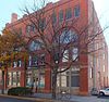 | May 17, 1984 (#84000881) | 212-222 W. 3rd Ave. 38°16′10″N 104°36′31″W / 38.269444°N 104.608611°W / 38.269444; -104.608611 (Henkel-Duke Mercantile Company Warehouse) | Pueblo | |
| 29 | Huerfano Bridge |  | February 4, 1985 (#85000226) | U.S. Highway 50 38°13′32″N 104°15′41″E / 38.22553°N 104.26142°E / 38.22553; 104.26142 (Huerfano Bridge) | Boone | 5-span filled spandrel arch completed in 1921 |
| 30 | Indian Petroglyphs and Pictographs | Upload image | May 3, 1976 (#76000566) | Address Restricted | Penrose vicinity | Known as "Indian Petroglyphs and Pictographs / Turkey Creek Canyon Rock Art District" by History Colorado,[6] while official NRHP listing name is just "Indian Petroglyphs and Pictographs". |
| 31 | Dr. Alexander T. King House and Carriage House |  | April 21, 1983 (#83001329) | 229 Quincy St. and 215 W. Routt Ave. 38°15′33″N 104°37′28″W / 38.259167°N 104.624444°W / 38.259167; -104.624444 (Dr. Alexander T. King House and Carriage House) | Pueblo | |
| 32 | McClelland Orphanage |  | January 30, 1992 (#91002043) | 415 E. Abriendo Ave. 38°15′22″N 104°37′00″W / 38.256111°N 104.616667°W / 38.256111; -104.616667 (McClelland Orphanage) | Pueblo | |
| 33 | Mechanics Building/Masonic Building | 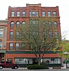 | June 16, 1983 (#83001330) | 207-211 N. Main St. 38°16′09″N 104°36′30″W / 38.269167°N 104.608333°W / 38.269167; -104.608333 (Mechanics Building/Masonic Building) | Pueblo | |
| 34 | Minnequa Steel Works Office Building and Dispensary, Colorado Fuel and Iron Company |  | June 6, 2002 (#02000628) | 215 and 225 Canal St. 38°14′17″N 104°36′45″W / 38.238056°N 104.6125°W / 38.238056; -104.6125 (Minnequa Steel Works Office Building and Dispensary, Colorado Fuel and Iron Company) | Pueblo | Designated a National Historic Landmark in 2021;[7] first major steel works west of the Mississippi. |
| 35 | Montgomery Ward Building |  | December 24, 1996 (#85003697) | 225 N. Main St. 38°16′10″N 104°36′30″W / 38.269444°N 104.608333°W / 38.269444; -104.608333 (Montgomery Ward Building) | Pueblo | |
| 36 | Orman-Adams House |  | July 13, 1976 (#76000567) | 102 W. Orman Ave. 38°15′17″N 104°37′39″W / 38.254722°N 104.6275°W / 38.254722; -104.6275 (Orman-Adams House) | Pueblo | |
| 37 | Pitkin Place Historic District |  | January 31, 1978 (#78000880) | Southern side of the 300 block of W. Pitkin Pl. 38°15′32″N 104°37′40″W / 38.258889°N 104.627778°W / 38.258889; -104.627778 (Pitkin Place Historic District) | Pueblo | |
| 38 | Frank Pryor House |  | February 8, 1985 (#85000231) | 1325 Greenwood St. 38°16′47″N 104°36′46″W / 38.279722°N 104.612778°W / 38.279722; -104.612778 (Frank Pryor House) | Pueblo | |
| 39 | Pueblo Christopher Columbus Monument |  | August 31, 2011 (#11000608) | Median in 100 block of E. Abriendo Ave. 38°15′34″N 104°37′15″W / 38.259444°N 104.620833°W / 38.259444; -104.620833 (Pueblo Christopher Columbus Monument) | Pueblo | |
| 40 | Pueblo City Park Zoo | 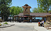 | July 28, 1995 (#95000934) | 3455 Nuckolls Ave. 38°15′43″N 104°39′20″W / 38.261944°N 104.655556°W / 38.261944; -104.655556 (Pueblo City Park Zoo) | Pueblo | |
| 41 | Pueblo County Courthouse |  | June 27, 1975 (#75000534) | 10th and Main Sts. 38°16′36″N 104°36′32″W / 38.276667°N 104.608889°W / 38.276667; -104.608889 (Pueblo County Courthouse) | Pueblo | |
| 42 | Pueblo Federal Building |  | January 3, 1978 (#78000881) | 421 N. Main St. 38°16′16″N 104°36′30″W / 38.271111°N 104.608333°W / 38.271111; -104.608333 (Pueblo Federal Building) | Pueblo | |
| 43 | Pueblo Mountain Park |  | December 6, 1994 (#94001343) | 1 mile south of County Road 220 on S. Pine Dr. (State Route 78) in the San Isabel National Forest 38°02′41″N 105°00′20″W / 38.044722°N 105.005556°W / 38.044722; -105.005556 (Pueblo Mountain Park) | Beulah | |
| 44 | Quaker Flour Mill | 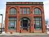 | September 30, 1976 (#76000568) | 102 S. Oneida St. 38°15′45″N 104°36′32″W / 38.2625°N 104.608889°W / 38.2625; -104.608889 (Quaker Flour Mill) | Pueblo | |
| 45 | Ward Rice House |  | November 7, 1985 (#85002762) | 1825 Grand Ave. 38°17′03″N 104°36′42″W / 38.284167°N 104.611667°W / 38.284167; -104.611667 (Ward Rice House) | Pueblo | |
| 46 | Rood Candy Company Building |  | May 17, 1984 (#84000882) | 408-416 W. 7th St. 38°16′23″N 104°36′43″W / 38.273056°N 104.611944°W / 38.273056; -104.611944 (Rood Candy Company Building) | Pueblo | |
| 47 | Roselawn Cemetery |  | June 19, 2017 (#100001212) | 1706 Roselawn Rd. 38°14′31″N 104°34′47″W / 38.241985°N 104.579643°W / 38.241985; -104.579643 (Roselawn Cemetery) | Pueblo | |
| 48 | Rosemount |  | July 30, 1974 (#74000592) | 419 W. 14th St. 38°16′49″N 104°36′44″W / 38.280278°N 104.612222°W / 38.280278; -104.612222 (Rosemount) | Pueblo | |
| 49 | Sacred Heart Church | 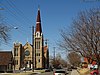 | February 21, 1989 (#89000037) | 1025 N. Grand Ave. 38°16′36″N 104°36′42″W / 38.276667°N 104.611667°W / 38.276667; -104.611667 (Sacred Heart Church) | Pueblo | |
| 50 | Sacred Heart Orphanage |  | March 3, 1989 (#89000038) | 2316 Sprague St. 38°14′27″N 104°38′18″W / 38.240833°N 104.638333°W / 38.240833; -104.638333 (Sacred Heart Orphanage) | Pueblo | |
| 51 | Santa Fe Avenue Bridge |  | October 15, 2002 (#02001149) | U.S. Highway 50 at milepost 1.33 38°15′15″N 104°36′23″W / 38.254167°N 104.606389°W / 38.254167; -104.606389 (Santa Fe Avenue Bridge) | Pueblo | |
| 52 | Squirrel Creek Recreational Unit | Upload image | March 28, 2005 (#05000215) | San Isabel National Forest 38°03′03″N 105°02′24″W / 38.050833°N 105.04°W / 38.050833; -105.04 (Squirrel Creek Recreational Unit) | Beulah | |
| 53 | St. Charles Bridge |  | February 4, 1985 (#85000228) | County Road 65 38°12′03″N 104°32′46″W / 38.200833°N 104.546111°W / 38.200833; -104.546111 (St. Charles Bridge) | Pueblo | |
| 54 | St. Charles River Bridge | Upload image | October 15, 2002 (#02001131) | US 50 at milepost 7.77 38°14′44″N 104°29′23″W / 38.245568°N 104.4895908°W / 38.245568; -104.4895908 (St. Charles River Bridge) | Pueblo | Replaced in 2006 |
| 55 | St. John's Greek Orthodox Church | 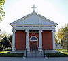 | February 28, 2002 (#02000123) | 1000-1010 Spruce St. 38°14′58″N 104°37′00″W / 38.249444°N 104.616667°W / 38.249444; -104.616667 (St. John's Greek Orthodox Church) | Pueblo | |
| 56 | St. Paul African Methodist Episcopal (AME) Church |  | March 10, 2023 (#100008733) | 613 West Mesa Ave. 38°14′46″N 104°37′06″W / 38.2461°N 104.6182°W / 38.2461; -104.6182 (St. Paul African Methodist Episcopal (AME) Church) | Pueblo | |
| 57 | Star Journal Model Home | 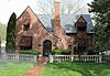 | February 16, 1984 (#84000886) | 2920 High St. 38°17′55″N 104°37′33″W / 38.298611°N 104.625833°W / 38.298611; -104.625833 (Star Journal Model Home) | Pueblo | |
| 58 | Charles H. Stickney House | 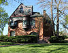 | February 8, 1985 (#85000232) | 101 E. Orman Ave. 38°15′16″N 104°37′36″W / 38.254444°N 104.626667°W / 38.254444; -104.626667 (Charles H. Stickney House) | Pueblo | |
| 59 | J.L. Streit House |  | September 20, 1984 (#84000892) | 2201 Grand Ave. 38°17′19″N 104°36′42″W / 38.288611°N 104.611667°W / 38.288611; -104.611667 (J.L. Streit House) | Pueblo | |
| 60 | Temple Emanuel |  | March 14, 1996 (#96000273) | 1325 N. Grand Ave. 38°16′47″N 104°36′44″W / 38.27965°N 104.61211°W / 38.27965; -104.61211 (Temple Emanuel) | Pueblo | Reform Jewish synagogue built in 1900, in Queen Anne style incorporating Richardsonian Romanesque elements |
| 61 | Tooke-Nuckolls House |  | November 7, 1985 (#85002763) | 38 Carlile Pl. 38°16′10″N 104°37′45″W / 38.269444°N 104.629167°W / 38.269444; -104.629167 (Tooke-Nuckolls House) | Pueblo | |
| 62 | Tutt Building |  | August 18, 1983 (#83001331) | 421 Central Plaza 38°16′07″N 104°36′29″W / 38.268611°N 104.608056°W / 38.268611; -104.608056 (Tutt Building) | Pueblo | |
| 63 | Union Avenue Historic Commercial District |  | December 28, 1982 (#82001021) | Roughly bounded by railroad tracks, Main St., Grand and Victoria Aves. 38°15′51″N 104°36′48″W / 38.264167°N 104.613333°W / 38.264167; -104.613333 (Union Avenue Historic Commercial District) | Pueblo | |
| 64 | Union Depot | 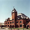 | April 1, 1975 (#75000535) | Victoria and B Sts. 38°15′46″N 104°36′59″W / 38.262778°N 104.616389°W / 38.262778; -104.616389 (Union Depot) | Pueblo | |
| 65 | Vail Hotel |  | December 18, 1978 (#78000882) | 217 S. Grand Ave. 38°15′59″N 104°37′18″W / 38.266389°N 104.621667°W / 38.266389; -104.621667 (Vail Hotel) | Pueblo | |
| 66 | Martin Walter House |  | May 17, 1984 (#84000894) | 300 W. Abriendo Ave. 38°15′42″N 104°37′28″W / 38.26159°N 104.62440°W / 38.26159; -104.62440 (Martin Walter House) | Pueblo | American Foursquare mansion built for founder of Pueblo Brewery |
| 67 | Asbury White House |  | October 11, 1984 (#84000025) | 417 W. 11th St. 38°16′38″N 104°36′42″W / 38.277222°N 104.611667°W / 38.277222; -104.611667 (Asbury White House) | Pueblo | |
| 68 | Young Women's Christian Association |  | March 24, 1980 (#80000921) | 801 N. Santa Fe Ave. 38°16′28″N 104°36′24″W / 38.274444°N 104.606667°W / 38.274444; -104.606667 (Young Women's Christian Association) | Pueblo |
Former listings
| [3] | Name on the Register | Image | Date listed | Date removed | Location | City or town | Description |
|---|---|---|---|---|---|---|---|
| 1 | Avondale Bridge |  | February 4, 1985 (#85000225) | March 27, 2017 | County Road 327 38°14′32″N 104°20′54″W / 38.242222°N 104.348333°W / 38.242222; -104.348333 (Avondale Bridge) | Avondale | No longer exists. Replaced in 2005. |
| 2 | Farris Hotel | Upload image | November 13, 1985 (#85003473) | April 22, 1991 | 315 N. Union Ave. | Pueblo | Demolished February 16, 1991.[8] |
| 3 | J. S. Glass Clothing Store | Upload image | September 18, 1978 (#85003473) | April 22, 1991 | 308 S. Union Ave. | Pueblo | Destroyed by fire February 6, 1983.[8] |
| 4 | T. G. McCarthy House | Upload image | May 22, 1986 (#86001122) | February 27, 1995 | 817 N. Grand Ave. | Pueblo | Demolished 1990.[8] |
| 5 | Nepesta Bridge | 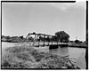 | February 4, 1985 (#85000227) | July 22, 1994 | County Road 613 over Arkansas River | Boone | Replaced in 1989[8] |
| 6 | Woodcroft Sanatorium | Upload image | December 3, 1985 (#85003101) | April 22, 1991 | 1300 W. Abriendo Ave. | Pueblo | Destroyed by fire February 10, 1988.[8] |
See also
 History portal
 United States portal
 Colorado portal
 National Register of Historic Places portal


- List of National Historic Landmarks in Colorado
- List of National Register of Historic Places in Colorado
- Bibliography of Colorado
- Geography of Colorado
- History of Colorado
- Index of Colorado-related articles
- List of Colorado-related lists
- Outline of Colorado
References
- ^ The latitude and longitude information provided in this table was derived originally from the National Register Information System, which has been found to be fairly accurate for about 99% of listings. Some locations in this table may have been corrected to current GPS standards.
- ^ National Park Service, United States Department of the Interior, "National Register of Historic Places: Weekly List Actions", retrieved June 28, 2024.
- ^ a b Numbers represent an alphabetical ordering by significant words. Various colorings, defined here, differentiate National Historic Landmarks and historic districts from other NRHP buildings, structures, sites or objects.
- ^ "National Register Information System". National Register of Historic Places. National Park Service. July 9, 2010.
- ^ The eight-digit number below each date is the number assigned to each location in the National Register Information System database, which can be viewed by clicking the number.
- ^ {{cite web|url=https://www.historycolorado.org/location/indian-petroglyphs-pictographs-turkey-creek-canyon-rock-art-district |title=Indian Petroglyphs & Pictographs / Turkey Creek Canyon Rock Art District |publisher=History Colorado
- ^ "Weekly listing". National Park Service.
- ^ a b c d e "Colorado Office of Archaeology and Historic Preservation | Properties removed from the National and State Registers". Archived from the original on 2012-08-18. Retrieved 2012-08-17.
External links
Wikimedia Commons has media related to Pueblo County, Colorado.
- State of Colorado
- History Colorado
- Pueblo County, Colorado
| |
|---|---|
| Topics | |
| Lists by state |
|
| Lists by insular areas | |
| Lists by associated state | |
| Other areas | |
| Related | |
| |


Municipalities and communities of Pueblo County, Colorado, United States | ||
|---|---|---|
County seat: Pueblo | ||
| City |  | |
| Towns | ||
| CDPs | ||
| Unincorporated communities | ||
| Ghost towns | ||
| ||
| |
|---|---|
Denver (capital) | |
| Topics |
|
| Society | |
| Cities |
|
| Counties |
|
| Regions |
|
 Colorado portal Colorado portal | |
| |||||||||||||||||||||||||||||||||
|---|---|---|---|---|---|---|---|---|---|---|---|---|---|---|---|---|---|---|---|---|---|---|---|---|---|---|---|---|---|---|---|---|---|
| Federal |
| ||||||||||||||||||||||||||||||||
| State |
| ||||||||||||||||||||||||||||||||
| Trails |
| ||||||||||||||||||||||||||||||||
38°10′24″N 104°30′46″W / 38.1732°N 104.5128°W / 38.1732; -104.5128 (Pueblo County, Colorado)


