National Register of Historic Places listings in Kane County, Illinois

This is a list of the National Register of Historic Places listings in Kane County, Illinois.
This is intended to be a complete list of the properties and districts on the National Register of Historic Places in Kane County, Illinois, United States. Latitude and longitude coordinates are provided for many National Register properties and districts; these locations may be seen together in a map.[1]
There are 81 properties and districts listed on the National Register in the county, and four former listings. One of the listings is also a National Historic Landmark.
This National Park Service list is complete through NPS recent listings posted September 13, 2024.[2]
Map all coordinates using OpenStreetMap
Download coordinates as:
- KML
- GPX (all coordinates)
- GPX (primary coordinates)
- GPX (secondary coordinates)
Current listings
| [3] | Name on the Register | Image | Date listed[4] | Location | City or town | Description |
|---|---|---|---|---|---|---|
| 1 | Arcada Theater Building |  | August 16, 1994 (#94000977) | 105 E. Main St. and 1st Ave. 41°54′49″N 88°18′43″W / 41.913611°N 88.311944°W / 41.913611; -88.311944 (Arcada Theater Building) | St. Charles | |
| 2 | Aurora Broadway Historic District | Upload image | February 7, 2023 (#100008483) | Roughly bounded by the Fox R., East New York St., the Burlington Northern & Santa Fe Railroad tracks, and East Benton St. 41°45′23″N 88°18′53″W / 41.7564°N 88.3146°W / 41.7564; -88.3146 (Aurora Broadway Historic District) | Aurora | |
| 3 | Aurora College Complex |  | February 16, 1984 (#84001126) | 347 S. Gladstone Ave. 41°45′17″N 88°20′52″W / 41.754722°N 88.347778°W / 41.754722; -88.347778 (Aurora College Complex) | Aurora | Eckhart, Davis, and Wilkinson Halls were the first buildings at Aurora College. The school, which moved to Aurora from Mendota, was long affiliated with the Advent Christian Church. Eckhart was the main hall, and the other two served as dormitories. |
| 4 | Aurora Elks Lodge No. 705 |  | March 31, 1980 (#80001369) | 77 S. Stolp Ave. 41°45′23″N 88°19′02″W / 41.756389°N 88.317222°W / 41.756389; -88.317222 (Aurora Elks Lodge No. 705) | Aurora | |
| 5 | Batavia Institute |  | August 13, 1976 (#76000712) | 333 S. Jefferson St. 41°50′40″N 88°18′59″W / 41.844444°N 88.316389°W / 41.844444; -88.316389 (Batavia Institute) | Batavia | |
| 6 | William Beith House | 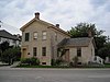 | December 7, 1983 (#83003575) | 6 Indiana St. 41°54′40″N 88°18′46″W / 41.911111°N 88.312778°W / 41.911111; -88.312778 (William Beith House) | St. Charles | |
| 7 | Campana Factory | 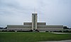 | April 6, 1979 (#79000841) | Roughly along Illinois Route 31 and Campana Rd. 41°51′54″N 88°18′58″W / 41.865°N 88.316111°W / 41.865; -88.316111 (Campana Factory) | Batavia | A state-of-the-art factory built in 1936 for The Campana Company, a cosmetics manufacturer. It is an example of the 1930s Streamline Moderne trend. The factory incorporated many innovative elements, such as air conditioning and a unique assembly line method. |
| 8 | Campton Town Hall |  | November 24, 1980 (#80001378) | W of Wasco at Town Hall Rd. and IL 64 41°55′56″N 88°25′45″W / 41.932222°N 88.429167°W / 41.932222; -88.429167 (Campton Town Hall) | Campton Hills | |
| 9 | Central Geneva Historic District | 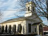 | September 10, 1979 (#79000845) | Roughly bounded by Fox River, South, 6th and W. State Sts.; also 0-200, 300-500 blocks S. 6th, 11-13 S. 7th, 600 blocks of State, James, Campbell, Fulton & South, 9,11 N. 2nd Sts. 41°53′08″N 88°18′30″W / 41.885556°N 88.308333°W / 41.885556; -88.308333 (Central Geneva Historic District) | Geneva | Second set of addresses represent a boundary increase approved July 10, 2017 |
| 10 | Chicago, Burlington, & Quincy Roundhouse and Locomotive Shop |  | February 16, 1978 (#78001154) | Broadway and Spring Sts. 41°45′39″N 88°18′30″W / 41.760833°N 88.308333°W / 41.760833; -88.308333 (Chicago, Burlington, & Quincy Roundhouse and Locomotive Shop) | Aurora | The roundhouse for the Chicago and Aurora Railroad (later Chicago, Burlington and Quincy Railroad) was a major employer in Aurora from 1856 to 1974. After it sat vacant for twenty-one years, a group of investors led by Walter Payton converted it into an entertainment complex. It is the oldest standing limestone roundhouse in the United States. |
| 11 | Chicago, Burlington, and Quincy Railroad Depot |  | June 6, 1979 (#79000842) | 155 Houston St. 41°51′05″N 88°18′37″W / 41.851389°N 88.310278°W / 41.851389; -88.310278 (Chicago, Burlington, and Quincy Railroad Depot) | Batavia | The 1854 Gothic Revival train station was the first built for the Chicago, Burlington, and Quincy Railroad. It was redicated as a museum in 1974. |
| 12 | City Building |  | March 21, 1979 (#79000847) | 15 N. Riverside Ave. 41°54′51″N 88°18′46″W / 41.914167°N 88.312778°W / 41.914167; -88.312778 (City Building) | St. Charles | |
| 13 | Col. Ira C. Copley Mansion |  | March 29, 1978 (#78001155) | 434 W. Downer Pl. 41°45′33″N 88°19′27″W / 41.759167°N 88.324167°W / 41.759167; -88.324167 (Col. Ira C. Copley Mansion) | Aurora | |
| 14 | Copley Hospital |  | April 18, 2019 (#100003648) | 301 Weston Ave. 41°44′49″N 88°19′05″W / 41.7469°N 88.3181°W / 41.7469; -88.3181 (Copley Hospital) | Aurora | |
| 15 | Corron Farm |  | May 21, 2018 (#100001925) | 7N761 Corron Rd. 41°58′49″N 88°24′18″W / 41.9803°N 88.4051°W / 41.9803; -88.4051 (Corron Farm) | St. Charles vicinity | |
| 16 | Country Tea Room |  | February 25, 1999 (#99000164) | 14N630 IL 25 42°04′36″N 88°15′36″W / 42.076667°N 88.26°W / 42.076667; -88.26 (Country Tea Room) | Dundee Township | A historic restaurant built along future Illinois Route 25. Max McGraw, who brought the Toastmaster to the domestic market, purchased the building in 1926 and thrived as a tearoom. It was later converted to a full restaurant to meet the changing demands of travelers. |
| 17 | George M. Crego Farm | Upload image | August 15, 2022 (#100007994) | 35854 Finley Rd. 41°48′40″N 88°28′29″W / 41.8112°N 88.4747°W / 41.8112; -88.4747 (George M. Crego Farm) | Sugar Grove vicinity | |
| 18 | Dundee Township Historic District |  | March 7, 1975 (#75000666) | Both sides of Fox River, including sections of E. Dundee, W. Dundee, and Carpentersville 42°06′07″N 88°16′55″W / 42.101944°N 88.281944°W / 42.101944; -88.281944 (Dundee Township Historic District) | East Dundee West Dundee Carpentersville | |
| 19 | Durant House | 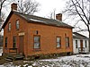 | June 18, 1976 (#76000714) | NW of St. Charles off Dean St. 41°55′38″N 88°20′50″W / 41.927222°N 88.347222°W / 41.927222; -88.347222 (Durant House) | St. Charles Township | |
| 20 | Dutch Mill | 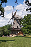 | June 4, 1979 (#79000843) | N of Batavia off IL 25 41°52′17″N 88°18′19″W / 41.871389°N 88.305278°W / 41.871389; -88.305278 (Dutch Mill) | Batavia | |
| 21 | Elgin Academy |  | October 8, 1976 (#76000713) | 350 Park St. 42°02′29″N 88°16′40″W / 42.041389°N 88.277778°W / 42.041389; -88.277778 (Elgin Academy) | Elgin | |
| 22 | Elgin Downtown Commercial District | 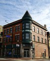 | December 22, 2014 (#14001067) | Roughly bounded by Division, Villa, Center, Fulton & Grove. 42°02′12″N 88°17′01″W / 42.036588°N 88.283507°W / 42.036588; -88.283507 (Elgin Downtown Commercial District) | Elgin | |
| 23 | Elgin Historic District | 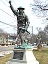 | May 9, 1983 (#83000318) | Roughly bounded by Villa, Center, Park, N. Liberty, and S. Channing Sts. 42°02′11″N 88°16′28″W / 42.0364°N 88.2744°W / 42.0364; -88.2744 (Elgin Historic District) | Elgin | |
| 24 | Elgin National Watch Company Observatory | 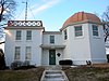 | August 16, 1994 (#94000976) | 312 Watch St. 42°01′48″N 88°16′24″W / 42.03°N 88.2733°W / 42.03; -88.2733 (Elgin National Watch Company Observatory) | Elgin | |
| 25 | Elgin Tower Building |  | May 22, 2002 (#02000542) | 100 E. Chicago St. 42°02′15″N 88°17′03″W / 42.0375°N 88.2843°W / 42.0375; -88.2843 (Elgin Tower Building) | Elgin | |
| 26 | Elizabeth Place |  | May 12, 2008 (#08000398) | 316 Elizabeth Pl. 41°52′46″N 88°18′39″W / 41.8794°N 88.3108°W / 41.8794; -88.3108 (Elizabeth Place) | Geneva | |
| 27 | Fabyan Villa |  | February 9, 1984 (#84001128) | 1511 S. Batavia Ave. 41°52′16″N 88°18′43″W / 41.8711°N 88.3119°W / 41.8711; -88.3119 (Fabyan Villa) | Geneva | |
| 28 | Fire Barn 5 |  | August 5, 1991 (#91001002) | 533 St. Charles Rd. 42°01′32″N 88°16′10″W / 42.0256°N 88.2694°W / 42.0256; -88.2694 (Fire Barn 5) | Elgin | |
| 29 | First Methodist Church of Batavia |  | March 19, 1982 (#82002546) | 355 1st St. 41°50′54″N 88°18′50″W / 41.8483°N 88.3139°W / 41.8483; -88.3139 (First Methodist Church of Batavia) | Batavia | |
| 30 | First Universalist Church |  | November 7, 1980 (#80001374) | 55 Villa St. 42°02′10″N 88°16′48″W / 42.0361°N 88.28°W / 42.0361; -88.28 (First Universalist Church) | Elgin | |
| 31 | Sam and Ruth Van Sickle Ford House |  | March 8, 2016 (#16000056) | 404 S. Edgelawn Dr. 41°45′12″N 88°21′33″W / 41.7534°N 88.3591°W / 41.7534; -88.3591 (Sam and Ruth Van Sickle Ford House) | Aurora | Designated a National Historic Landmark in 2023. |
| 32 | Fox River House | 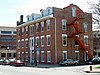 | May 4, 1976 (#76000710) | 166 W. Galena 41°45′32″N 88°19′04″W / 41.7589°N 88.3178°W / 41.7589; -88.3178 (Fox River House) | Aurora | |
| 33 | GAR Memorial Building | 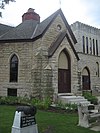 | August 23, 1984 (#84001130) | 23 E. Downer Pl. 41°45′24″N 88°18′56″W / 41.7567°N 88.3156°W / 41.7567; -88.3156 (GAR Memorial Building) | Aurora | |
| 34 | Garfield Farm and Tavern |  | June 23, 1978 (#78001156) | 3NO16 Garfield Rd. 41°54′36″N 88°24′01″W / 41.91°N 88.4003°W / 41.91; -88.4003 (Garfield Farm and Tavern) | Campton Hills | |
| 35 | Geneva Country Day School |  | August 21, 1989 (#89001111) | 1250 South St. 41°52′59″N 88°19′13″W / 41.8831°N 88.3203°W / 41.8831; -88.3203 (Geneva Country Day School) | Geneva | |
| 36 | Gifford–Davidson House |  | May 31, 1980 (#80001375) | 363-365 Prairie St. 42°02′03″N 88°16′39″W / 42.0342°N 88.2775°W / 42.0342; -88.2775 (Gifford–Davidson House) | Elgin | |
| 37 | Graham Building | 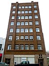 | March 19, 1982 (#82002543) | 33 S. Stolp Ave. 41°45′26″N 88°18′57″W / 41.7572°N 88.3158°W / 41.7572; -88.3158 (Graham Building) | Aurora | |
| 38 | Gray–Watkins Mill |  | December 17, 1979 (#79000846) | 211 N. River St. 41°43′46″N 88°20′25″W / 41.7294°N 88.3403°W / 41.7294; -88.3403 (Gray–Watkins Mill) | Montgomery | |
| 39 | Mrs. A. W. Gridley House | 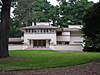 | February 3, 1993 (#92001850) | 637 N. Batavia Ave. 41°51′36″N 88°18′49″W / 41.86°N 88.3136°W / 41.86; -88.3136 (Mrs. A. W. Gridley House) | Batavia | |
| 40 | Healy Chapel | 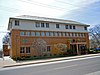 | February 28, 1985 (#85000361) | 332 W. Downer Pl. 41°45′33″N 88°19′23″W / 41.7592°N 88.3231°W / 41.7592; -88.3231 (Healy Chapel) | Aurora | |
| 41 | Hobbs Building |  | June 17, 2021 (#100006645) | 2-4 North River St. 41°45′33″N 88°19′00″W / 41.7593°N 88.3168°W / 41.7593; -88.3168 (Hobbs Building) | Aurora | |
| 42 | Holy Cross Church | 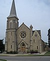 | May 20, 1999 (#99000587) | 14 N. Van Buren St. 41°51′01″N 88°18′10″W / 41.8503°N 88.3028°W / 41.8503; -88.3028 (Holy Cross Church) | Batavia | |
| 43 | Hotel Arthur |  | March 15, 2005 (#04001300) | 2-4 N. Broadway 41°45′33″N 88°18′47″W / 41.7592°N 88.3131°W / 41.7592; -88.3131 (Hotel Arthur) | Aurora | |
| 44 | Hotel Aurora | 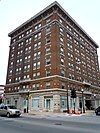 | June 3, 1982 (#82002544) | 2 N. Stolp Ave. 41°45′30″N 88°18′54″W / 41.758333°N 88.315°W / 41.758333; -88.315 (Hotel Aurora) | Aurora | |
| 45 | Hotel Baker |  | December 8, 1978 (#78001157) | 100 W. Main St. 41°54′49″N 88°18′54″W / 41.913611°N 88.315°W / 41.913611; -88.315 (Hotel Baker) | St. Charles | |
| 46 | Joel H. Hulburd House | 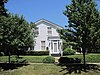 | May 4, 2011 (#11000244) | 304 N. 2nd Ave. 41°54′59″N 88°18′43″W / 41.916389°N 88.311944°W / 41.916389; -88.311944 (Joel H. Hulburd House) | St. Charles | |
| 47 | Hunt House |  | November 12, 1982 (#82000397) | 304 Cedar Ave. 41°54′54″N 88°18′38″W / 41.915°N 88.310556°W / 41.915; -88.310556 (Hunt House) | St. Charles | |
| 48 | International Harvester Showroom and Warehouse | Upload image | January 31, 2022 (#100005050) | 6,12 North River St. 41°45′34″N 88°19′00″W / 41.7594°N 88.3167°W / 41.7594; -88.3167 (International Harvester Showroom and Warehouse) | Aurora | |
| 49 | Keystone Building |  | March 18, 1980 (#80001370) | 30 S. Stolp Ave. 41°45′26″N 88°18′57″W / 41.757222°N 88.315833°W / 41.757222; -88.315833 (Keystone Building) | Aurora | |
| 50 | Larkin Home for Children | 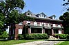 | December 31, 2018 (#100003264) | 1212 Larkin Ave. 42°02′11″N 88°18′32″W / 42.036355°N 88.308874°W / 42.036355; -88.308874 (Larkin Home for Children) | Elgin | |
| 51 | LaSalle Street Auto Row Historic District |  | August 1, 1996 (#96000856) | 56-84 LaSalle St. and 57-83 S. LaSalle St. 41°45′18″N 88°18′48″W / 41.755°N 88.313333°W / 41.755; -88.313333 (LaSalle Street Auto Row Historic District) | Aurora | |
| 52 | Library Hall |  | August 14, 1973 (#73000709) | 21 N. Washington St. 42°06′37″N 88°17′16″W / 42.110278°N 88.287778°W / 42.110278; -88.287778 (Library Hall) | Carpentersville | |
| 53 | Abraham Lincoln School | Upload image | April 12, 2022 (#100007585) | 641 South Lake St. 41°44′57″N 88°19′58″W / 41.7492°N 88.3327°W / 41.7492; -88.3327 (Abraham Lincoln School) | Aurora | |
| 54 | Masonic Temple | 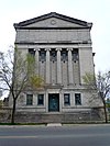 | March 19, 1982 (#82002545) | 104 S. Lincoln Ave. 41°45′12″N 88°18′46″W / 41.753333°N 88.312778°W / 41.753333; -88.312778 (Masonic Temple) | Aurora | Destroyed in a 2019 fire[5] |
| 55 | Memorial Washington Reformed Presbyterian Church |  | November 19, 1980 (#80001376) | West of Elgin on W. Highland Ave. Rd. 42°03′51″N 88°23′28″W / 42.064167°N 88.391111°W / 42.064167; -88.391111 (Memorial Washington Reformed Presbyterian Church) | Elgin | |
| 56 | Middle Avenue Historic District |  | October 24, 2016 (#16000735) | Bounded by S. Lake, Cross, S. River & Gale Sts. 41°45′19″N 88°19′23″W / 41.755266°N 88.323145°W / 41.755266; -88.323145 (Middle Avenue Historic District) | Aurora | |
| 57 | Robert and Elizabeth Muirhead House | 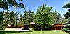 | January 12, 2016 (#15000965) | 42W814 Rohrson Rd. 42°02′09″N 88°27′02″W / 42.035837°N 88.450635°W / 42.035837; -88.450635 (Robert and Elizabeth Muirhead House) | Plato Center | |
| 58 | North Geneva Historic District | 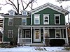 | March 25, 1982 (#82002549) | Roughly bounded by RR tracks, Fox River, Stevens and W. State Sts.; also 100-200 N. River Ln. 41°53′23″N 88°18′30″W / 41.889722°N 88.308333°W / 41.889722; -88.308333 (North Geneva Historic District) | Geneva | Second set of addresses represent a boundary increase approved July 10, 2017 |
| 59 | Oaklawn Farm | 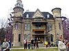 | July 26, 1979 (#79000848) | Army Trail and Dunham Rds. 41°57′02″N 88°16′10″W / 41.950556°N 88.269444°W / 41.950556; -88.269444 (Oaklawn Farm) | Wayne | |
| 60 | Old Second National Bank | 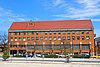 | May 8, 1979 (#79000840) | 37 S. River St. 41°45′28″N 88°19′06″W / 41.757778°N 88.318333°W / 41.757778; -88.318333 (Old Second National Bank) | Aurora | |
| 61 | Paramount Theatre | 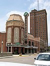 | March 18, 1980 (#80001371) | 23 E. Galena Blvd. 41°45′25″N 88°18′54″W / 41.756944°N 88.315°W / 41.756944; -88.315 (Paramount Theatre) | Aurora | |
| 62 | Ora Pelton House |  | August 12, 1982 (#82002548) | 214 S. State St. 42°01′49″N 88°17′01″W / 42.030278°N 88.283611°W / 42.030278; -88.283611 (Ora Pelton House) | Elgin | |
| 63 | Potter and Barker Grain Elevator |  | December 27, 2016 (#16000899) | 1N298 La Fox Rd. 41°53′14″N 88°24′34″W / 41.887240°N 88.409391°W / 41.887240; -88.409391 (Potter and Barker Grain Elevator) | La Fox | |
| 64 | Pure Oil Station |  | April 23, 2013 (#13000186) | 502 W. State St. 41°53′17″N 88°18′40″W / 41.888107°N 88.31104°W / 41.888107; -88.31104 (Pure Oil Station) | Geneva | |
| 65 | Riverbank Laboratories |  | November 28, 2003 (#03001204) | 1512 Batavia Ave. 41°52′18″N 88°18′50″W / 41.871667°N 88.313889°W / 41.871667; -88.313889 (Riverbank Laboratories) | Geneva | |
| 66 | St. Charles Hospital |  | June 7, 2010 (#10000312) | 400 E New York St. 41°45′25″N 88°18′27″W / 41.756822°N 88.307425°W / 41.756822; -88.307425 (St. Charles Hospital) | Aurora | |
| 67 | St. Charles Municipal Building |  | February 21, 1991 (#91000087) | 2 E. Main St. 41°54′50″N 88°18′46″W / 41.913889°N 88.312778°W / 41.913889; -88.312778 (St. Charles Municipal Building) | St. Charles | |
| 68 | St. Mary's Church of Gilberts |  | August 18, 1992 (#92001018) | 10 Mattesen St. 42°06′23″N 88°22′30″W / 42.106389°N 88.375°W / 42.106389; -88.375 (St. Mary's Church of Gilberts) | Gilberts | |
| 69 | Ephraim Smith House |  | June 6, 1980 (#80001377) | NE of Sugar Grove 41°47′12″N 88°26′52″W / 41.786667°N 88.447778°W / 41.786667; -88.447778 (Ephraim Smith House) | Sugar Grove Township | |
| 70 | Spring–Douglas Historic District |  | April 28, 2000 (#00000410) | Roughly Spring St. and Douglas Ave., bet. River Bluff Rd. and Kimball Ave. 42°03′03″N 88°17′04″W / 42.050833°N 88.284444°W / 42.050833; -88.284444 (Spring–Douglas Historic District) | Elgin | |
| 71 | Stearns–Wadsworth House |  | March 19, 1982 (#82002547) | 1 S. 570 Bliss Rd. 41°50′40″N 88°24′26″W / 41.844444°N 88.407222°W / 41.844444; -88.407222 (Stearns–Wadsworth House) | Blackberry Township | |
| 72 | Stolp Island Historic District |  | September 10, 1986 (#86001487) | Stolp Island 41°45′27″N 88°18′56″W / 41.7575°N 88.315556°W / 41.7575; -88.315556 (Stolp Island Historic District) | Aurora | |
| 73 | Stolp Woolen Mill Store | 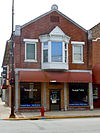 | September 1, 1983 (#83000319) | 2 W. Downer Pl. 41°45′25″N 88°18′59″W / 41.756944°N 88.316389°W / 41.756944; -88.316389 (Stolp Woolen Mill Store) | Aurora | |
| 74 | William A. Tanner House |  | August 19, 1976 (#76000711) | 304 Oak Ave. 41°45′49″N 88°19′06″W / 41.763611°N 88.318333°W / 41.763611; -88.318333 (William A. Tanner House) | Aurora | |
| 75 | Mary A. Todd School | Upload image | April 12, 2022 (#100007584) | 100 Oak Ave. 41°45′43″N 88°19′09″W / 41.7620°N 88.3193°W / 41.7620; -88.3193 (Mary A. Todd School) | Aurora | |
| 76 | United Methodist Church of Batavia |  | July 28, 1983 (#83000320) | 8 N. Batavia Ave. 41°51′02″N 88°18′42″W / 41.850556°N 88.311667°W / 41.850556; -88.311667 (United Methodist Church of Batavia) | Batavia | |
| 77 | Andrew Weisel House |  | February 26, 1982 (#82002550) | 312 N. 2nd Ave. 41°54′59″N 88°18′42″W / 41.916389°N 88.311667°W / 41.916389; -88.311667 (Andrew Weisel House) | St. Charles | |
| 78 | West Side Historic District |  | August 13, 1986 (#86001484) | Roughly bounded by W. Downer Pl., Lake St., Garfield Ave., and S. Highland St. 41°45′11″N 88°19′31″W / 41.753056°N 88.325278°W / 41.753056; -88.325278 (West Side Historic District) | Aurora | |
| 79 | Louise White School |  | November 7, 1980 (#80001373) | Washington Ave. 41°51′03″N 88°18′14″W / 41.850833°N 88.303889°W / 41.850833; -88.303889 (Louise White School) | Batavia | |
| 80 | Judge Isaac Wilson House |  | May 9, 1985 (#85000978) | 406 E. Wilson St. 41°51′00″N 88°18′04″W / 41.85°N 88.301111°W / 41.85; -88.301111 (Judge Isaac Wilson House) | Batavia | |
| 81 | Wing Park Golf Course | 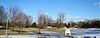 | February 18, 2009 (#09000027) | 1000 Wing St. 42°02′51″N 88°18′17″W / 42.047486°N 88.304622°W / 42.047486; -88.304622 (Wing Park Golf Course) | Elgin |
Former listings
| [3] | Name on the Register | Image | Date listed | Date removed | Location | City or town | Description |
|---|---|---|---|---|---|---|---|
| 1 | Aurora Watch Factory | Upload image | May 8, 1986 (#86001009) | December 8, 1995 | 603 - 621 LaSalle St. | Aurora | Destroyed by fire, December 17, 1989.[6] |
| 2 | Elgin Milk Condensing Co./Illinois Condensing Co. | Upload image | February 14, 1985 (#85000267) | April 17, 2003 | Brook and Water Streets | Elgin | Demolished in 1998.[7] |
| 3 | Hartsburg and Hawksley Saw Mill | Upload image | July 11, 1974 (#74002283) | March 17, 1975 | 25 East State Street | North Aurora | Demolished in 1974 |
| 4 | Old Hotel | Upload image | September 21, 1989 (#89001464) | March 14, 2002 | 241 Main Street | Sugar Grove | Demolished in April 1999 |
| 5 | Teeple Barn |  | December 10, 1979 (#79000844) | January 2, 2020 | NW of Elgin on Randall Rd. 42°04′39″N 88°20′06″W / 42.0775°N 88.335°W / 42.0775; -88.335 (Teeple Barn) | Elgin | Destroyed in a 2007 storm.[8] |
See also
Wikimedia Commons has media related to National Register of Historic Places in Kane County, Illinois.
- List of National Historic Landmarks in Illinois
- National Register of Historic Places listings in Illinois
References
- ^ The latitude and longitude information provided in this table was derived originally from the National Register Information System, which has been found to be fairly accurate for about 99% of listings. Some locations in this table may have been corrected to current GPS standards.
- ^ National Park Service, United States Department of the Interior, "National Register of Historic Places: Weekly List Actions", retrieved September 13, 2024.
- ^ a b Numbers represent an alphabetical ordering by significant words. Various colorings, defined here, differentiate National Historic Landmarks and historic districts from other NRHP buildings, structures, sites or objects.
- ^ The eight-digit number below each date is the number assigned to each location in the National Register Information System database, which can be viewed by clicking the number.
- ^ "Fire destroys history as Lincoln Masonic Temple burns in Aurora". 8 October 2019.
- ^ "Historian lament fire in Aurora". The Chicago Tribune. December 21, 1989. p. Section 2, page 1. Retrieved June 21, 2022 – via Newspapers.com.
- ^ "Archived copy" (PDF). Archived from the original (PDF) on 2013-12-24. Retrieved 2014-01-12.
{{cite web}}: CS1 maint: archived copy as title (link) - ^ "Preservationists say $100.000 needed to save historic barn -- Daily Herald". 26 February 2008.
- v
- t
- e
- Adams
- Alexander
- Bond
- Boone
- Brown
- Bureau
- Calhoun
- Carroll
- Cass
- Champaign
- Christian
- Clark
- Clay
- Clinton
- Coles
- Cook
- Crawford
- Cumberland
- DeKalb
- DeWitt
- Douglas
- DuPage
- Edgar
- Edwards
- Effingham
- Fayette
- Ford
- Franklin
- Fulton
- Gallatin
- Greene
- Grundy
- Hamilton
- Hancock
- Hardin
- Henderson
- Henry
- Iroquois
- Jackson
- Jasper
- Jefferson
- Jersey
- Jo Daviess
- Johnson
- Kane
- Kankakee
- Kendall
- Knox
- LaSalle
- Lake
- Lawrence
- Lee
- Livingston
- Logan
- Macon
- Macoupin
- Madison
- Marion
- Marshall
- Mason
- Massac
- McDonough
- McHenry
- McLean
- Menard
- Mercer
- Monroe
- Montgomery
- Morgan
- Moultrie
- Ogle
- Peoria
- Perry
- Piatt
- Pike
- Pope
- Pulaski
- Putnam
- Randolph
- Richland
- Rock Island
- St. Clair
- Saline
- Sangamon
- Schuyler
- Scott
- Shelby
- Stark
- Stephenson
- Tazewell
- Union
- Vermilion
- Wabash
- Warren
- Washington
- Wayne
- White
- Whiteside
- Will
- Williamson
- Winnebago
- Woodford

- Bridges
- Houses
- National Historic Landmarks
- Properties of religious function
- Railway stations


