National Register of Historic Places listings in Grayson County, Kentucky
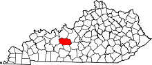
This is a list of the National Register of Historic Places listings in Grayson County, Kentucky.
This is intended to be a complete list of the properties and districts on the National Register of Historic Places in Grayson County, Kentucky, United States. The locations of National Register properties and districts for which the latitude and longitude coordinates are included below, may be seen in a map.[1]
There are 11 properties and districts listed on the National Register in the county.
This National Park Service list is complete through NPS recent listings posted September 5, 2024.[2]
Map all coordinates using OpenStreetMap
Download coordinates as:
- KML
- GPX (all coordinates)
- GPX (primary coordinates)
- GPX (secondary coordinates)
Current listings
| [3] | Name on the Register | Image | Date listed[4] | Location | City or town | Description |
|---|---|---|---|---|---|---|
| 1 | The Cedars |  | May 17, 1976 (#76000889) | East of Leitchfield on Kentucky Route 1214 37°28′28″N 86°15′26″W / 37.474444°N 86.257222°W / 37.474444; -86.257222 (The Cedars) | Leitchfield | |
| 2 | Court Square Historic District |  | November 23, 1984 (#84000288) | Court House Square between Walnut and Market Sts.; also 106 and 104 N. Main 37°28′48″N 86°17′38″W / 37.480000°N 86.293889°W / 37.480000; -86.293889 (Court Square Historic District) | Leitchfield | Addresses on N. Main St. are a boundary increase |
| 3 | Crow Hollow Petroglyphs (15GY65) | Upload image | September 8, 1989 (#89001188) | Address Restricted | Clarkson | |
| 4 | Falls of Rough Historic District |  | January 31, 1978 (#78001305) | Kentucky Route 110 37°35′21″N 86°33′07″W / 37.589167°N 86.551944°W / 37.589167; -86.551944 (Falls of Rough Historic District) | Falls of Rough | Extends into Breckinridge County |
| 5 | Grayson Springs |  | December 6, 1978 (#78001334) | South of Clarkson 37°27′37″N 86°13′29″W / 37.460278°N 86.224722°W / 37.460278; -86.224722 (Grayson Springs) | Clarkson | |
| 6 | Hunter House |  | May 16, 1985 (#85001055) | 118 W. Walnut St. 37°28′53″N 86°17′42″W / 37.481389°N 86.295138°W / 37.481389; -86.295138 (Hunter House) | Leitchfield | |
| 7 | St. Augustine Catholic Church | 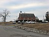 | April 7, 1989 (#89000259) | Kentucky Route 88 37°27′02″N 86°13′57″W / 37.450556°N 86.232500°W / 37.450556; -86.232500 (St. Augustine Catholic Church) | Grayson Springs | |
| 8 | Saltsman Branch Petroglyphs (15GY66) | Upload image | September 8, 1989 (#89001189) | Address Restricted | Moutardier | |
| 9 | Saltsman Branch Shelter Petroglyphs (15GY67) | Upload image | September 8, 1989 (#89001190) | Address Restricted | Moutardier | |
| 10 | Jack Thomas House |  | April 21, 1976 (#76000890) | 108 E. Main St. 37°28′47″N 86°17′32″W / 37.479861°N 86.292222°W / 37.479861; -86.292222 (Jack Thomas House) | Leitchfield | |
| 11 | Walnut Grove School | Upload image | February 2, 1988 (#87002516) | Walnut Grove Rd. 37°26′38″N 86°30′18″W / 37.443889°N 86.505000°W / 37.443889; -86.505000 (Walnut Grove School) | Caneyville |
See also
Wikimedia Commons has media related to National Register of Historic Places in Grayson County, Kentucky.
- List of National Historic Landmarks in Kentucky
- National Register of Historic Places listings in Kentucky
References
- ^ The latitude and longitude information provided in this table was derived originally from the National Register Information System, which has been found to be fairly accurate for about 99% of listings. Some locations in this table may have been corrected to current GPS standards.
- ^ National Park Service, United States Department of the Interior, "National Register of Historic Places: Weekly List Actions", retrieved September 5, 2024.
- ^ Numbers represent an alphabetical ordering by significant words. Various colorings, defined here, differentiate National Historic Landmarks and historic districts from other NRHP buildings, structures, sites or objects.
- ^ The eight-digit number below each date is the number assigned to each location in the National Register Information System database, which can be viewed by clicking the number.
- v
- t
- e
- List of U.S. National Historic Landmarks by state:
- Alabama
- Alaska
- Arizona
- Arkansas
- California
- Colorado
- Connecticut
- Delaware
- Florida
- Georgia
- Hawaii
- Idaho
- Illinois
- Indiana
- Iowa
- Kansas
- Kentucky
- Louisiana
- Maine
- Maryland
- Massachusetts
- Michigan
- Minnesota
- Mississippi
- Missouri
- Montana
- Nebraska
- Nevada
- New Hampshire
- New Jersey
- New Mexico
- New York
- North Carolina
- North Dakota
- Ohio
- Oklahoma
- Oregon
- Pennsylvania
- Rhode Island
- South Carolina
- South Dakota
- Tennessee
- Texas
- Utah
- Vermont
- Virginia
- Washington
- West Virginia
- Wisconsin
- Wyoming
 National Register of Historic Places portal
 Category


Municipalities and communities of Grayson County, Kentucky, United States | ||
|---|---|---|
County seat: Leitchfield | ||
| Cities |  | |
| CDP | ||
| Other unincorporated communities | ||
| Footnotes | ‡This populated place also has portions in an adjacent county or counties | |
| ||


